|
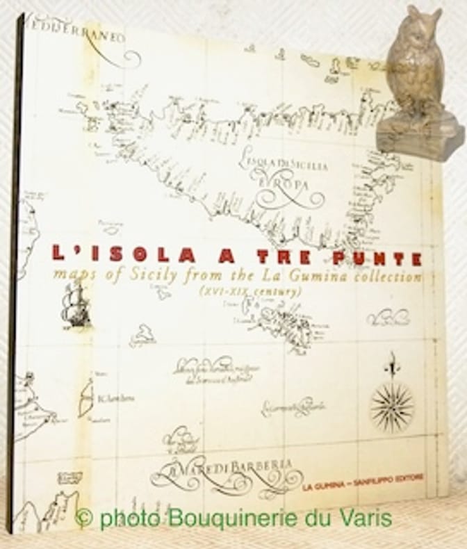
Iachello, Enrico.
L’isola a tre punte maps of Sicily from the La Gumina collection (XVIe-XIX Century).
Catania, La Gumina - Sanfilipo Editore 1999, 230x220mm, 191pages, paperback. Book in good condition.
Référence libraire : 110522
|
|
|
Ign Cartes
Autrans gorges de la bourne
France: IGN Cartes. Good. Paperback. 1989. scale 1:25000 some slight fold wear<br><p></p> . IGN Cartes paperback
Référence libraire : 2945bo

|
|
|
Ign Cartes
Tullins series bleue 1:25000 1cm pour 250 m
France: IGN. Good. Paperback. 1985. <br><p></p> . IGN paperback
Référence libraire : 2945bn

|
|
|
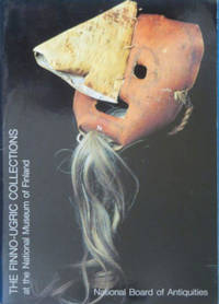
Ildikó Lehtinen ; [photos: National Board of Antiquities] ; [maps: Raija Annala]
The Finno-Ugric collections at the National Museum of Finland
Helsinki Finland: National Board of Antiquities 1990. Trade paperback. Very good/Not issued. 25 cm. National Board of Antiquities. Paperback • Illustrations some color maps • <b><i>English text translated from Finnish</i></b> • Printed 1990 • No inscriptions. National Board of Antiquities paperback
Référence libraire : PM335401U ISBN : 9519075410 9789519075419
|
|
|
ILHAN PINAR
Izmir city plans and maps from the Ottoman Era.= Osmanli dönemi Izmir planlari ve haritalari.
New English Original decorative cloth bdg. Folio. (33 x 33 cm). In English and Turkish.155 p., color and b/w ills., maps (some folded). Some of plans - maps and their makers from the contents of book: "The earliest city planning sketches displaying the then status of the city are the plans drawn by Livio Amedeo Missir located at the Santa Maria Church.", The well-known geographer Jean Denis barbie de Bocage's plan, In 1830s, British Navy Officer's plans, Luigi Storari's plan, Lamec Saad's plan, Charles Goad's plans, Karl Baedeker's plans, and very important maps of Izmir (Smyrna - Smyrne) city. 500 copies were printed.
|
|
|
ILLE ET VILAINE
Carte grav?e (en noir) du d?partement. Extrait du Petit Atlas National. Fin XIXe.
1 feuille 24x30 cm. Rousseurs.
|
|
|
ILLE ET VILAINE
Carte routi?re d?partementale couleurs au 1/320 000?.
Une feuille 58x39 cm.
|
|
|
Illinois. Chicago. Guidebook.
Rand McNally Chicago Guide
Chicago & New York: Rand McNally 1927. First edition thus. Pictorial Boards. Very Good. Octavo 142 pages; inked name on top cover of Mrs. Clyde Yoher Monongahela Pa <br/><br/>With many crisp b&w photogravures and a large fold-out map of the Chicago Business District tipped to the rear inside cover. Rand, McNally hardcover
Référence libraire : 250487
|
|
|
Illustrated in Color Maps
1978 Los Angeles Times Orange County Los Angeles Glove Compartment Street Atlas Complete Street Index California With Color Maps Places of Interest Cemeteries Colleges Beaches Amusement Parks Legitimate Theatre Golf Courses Museums Hotels ET
CReated & Publ. Gousha/Chek-Chart San Jose Mitock North Hollywood 1978. PBO Spiral Bound Softcover 1978 1st Edition Nice Condition You turn over Book to Back for different 2 Counties NF/NF- SOFTCOVER COVER light ruB wear Creases & Scuff Hotels ETC Orange County & Los Angeles Street Index. First Edition. Soft Cover. CReated & Publ. Gousha/Chek-Chart, San Jose Mitock North Hollywood paperback
Référence libraire : 23102
|
|
|
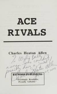
Illustrated With Maps. Allen, Charles
Ace Rival
Baywood Publishing 1995-01-01. paperback. New. In shrink wrap. Looks like an interesting title! Baywood Publishing paperback
Référence libraire : Q-0964540401 ISBN : 0964540401 9780964540408
|
|
|
Illustrated With Maps. Allen Charles
Ace Rival
paperback. Good. Access codes and supplements are not guaranteed with used items. May be an ex-library book. paperback
Référence libraire : 0964540401.G ISBN : 0964540401 9780964540408
|
|
|
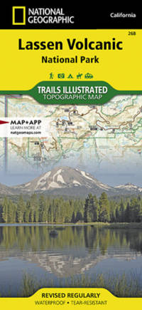
Illustrated, National Geographic Maps - Trails
Lassen Volcanic National Park National Geographic Trails Illustrated Map
like new. unknown
Référence libraire : 21457133 ISBN : 156695679x 9781566956796
|
|
|
Illustrated, National Geographic Maps - Trails
Lassen Volcanic National Park National Geographic Trails Illustrated Map
new. unknown
Référence libraire : 21457133-n ISBN : 156695679x 9781566956796
|
|
|
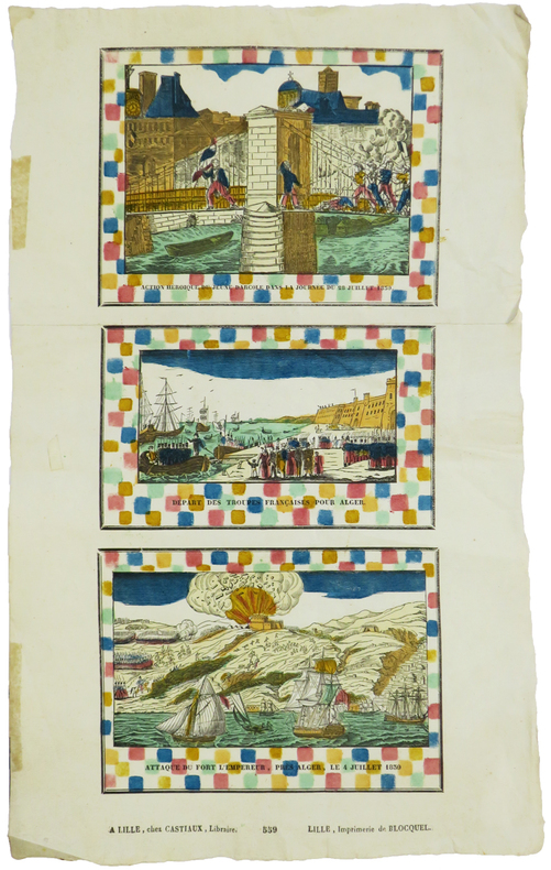
IMAGERIE de LILLE & RÉVOLUTION de JUILLET.
Action héroïque du jeune Darcole dans la journée du 28 juillet 1830 - Départ des troupes françaises pour Alger - Attaque du Fort l'Empereur, près Alger, le 4 juillet 1830.
Lille, Castiaux et Imprimerie de Blocquel, [circa 1830]. En deux feuilles jointes de 400 x 168 mm.
Référence libraire : LBW-5888
|
|
|
Imbert Pierre
Bridge contrat. Le bridge national français, deux-trèfles, blackwood, chelems
Editions du vieux Monaco Brochure 1947 In-12 (11,5 x 17,7 cm), brochure, 95 pages ; rousseurs et quelques marques d'usage sur les plats,par ailleurs assez bon état général. Livraison a domicile (La Poste) ou en Mondial Relay sur simple demande.
Référence libraire : dm504
|
|
|
Imfeld, X(aver)
Gebirgspanorama vom Belvedère auf dem Zürichberg. Erweiterte Ausgabe des Zürichbergpanorama's oberhalb der Karolinenburg von Alb(ert) Heim.
Zürich, Caesar Schmidt, o.J. (1877). Gef. Federlithographie (Leporello) in Halbleinenumschlag (8°). Bildformat: 16,8 x 167 cm. Blattformat: 19,1 x 168 cm. + Wichtig: Für unsere Kunden in der EU erfolgt der Versand alle 14 Tage verzollt ab Deutschland / Postbank-Konto in Deutschland vorhanden +, 1544A (Einbanddeckel stärker berieben und bestossen).
Référence libraire : 1544AG

|
|
|
IMHOF, Eduard:
Die Ältesten Schweizerkarten. Mit einem Faksimile der ältesten gedruckten Schweizerkarte von 1513 und 3 Abbildungen.
Zürich / Leipzig Orell Füssli Verlag, 1939, in-4to, (Querformat), 15 S. mit 3 Abb. + 1 gef. Kartenbeilage ‘Tabula Nova Heremi Helvetioru’ (ca. 44x57 cm), Original-Pappband mit Titelschild, Orig.-Umschlag.
Référence libraire : 129530aaf
|
|
|
IMHOF, Eduard:
Landkartenkunst, gestern, heute, morgen. Hrsg. v.d. Naturforschenden Gesellschaft in Zürich auf das Jahr 1968. 170. Stück,
Zürich, Kommissionsverlag Leemann AG., 1968, in-8vo, 35 S., 17 s./w. ill + 3 farbtafeln, Original-Broschüre.
Référence libraire : 126359aaf
|
|
|
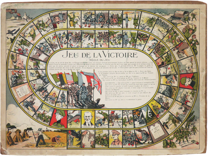
IMPRIMERIE CHAMBRELENT.
Jeu de la Victoire.
Paris, Imp. Chambrelent, [1919]. 277 x 370 mm ; monté sur carton.
Référence libraire : LBW-8571
|
|
|
in Full Color, Blank Flyleaf Small Sticker Former Owner. SIGNED By Author Brown, Illustrations By Velma Grant, Maps By George An
Rock & Miinerals of California & Their Stories
Naturegraph Co San Martin Calif. PBO decorated color Wraps with Color Labels of rocks Light rub Wear & tiny Chips Tears Extremities NF-/NF- 1955 Interior Nice tight Clean light Rub Wear FoX 120 Pages InDex some pgs light Wrinkling . Signed by Author. First Edition. Original Wraps. Naturegraph Co, San Martin, Calif. paperback
Référence libraire : 21242
|
|
|
Inc Hedberg Maps
Air Travelers' Map & Guide
map. Good. Access codes and supplements are not guaranteed with used items. May be an ex-library book. unknown
Référence libraire : 1593530242.G ISBN : 1593530242 9781593530242
|
|
|
Inc Key Maps
Houston Harris County atlas
good. spiral bound softcover cover and corner wear creased covers paperback
Référence libraire : 050421A280103 ISBN : 1885822103 9781885822109
|
|
|
Inc Trakker Maps
Miami City Slickers
map. Good. Access codes and supplements are not guaranteed with used items. May be an ex-library book. unknown
Référence libraire : 1877651710.G ISBN : 1877651710 9781877651717
|
|
|
Inc Wide World of Maps
Yellow 1 Pinal County Street and Road Atlas - 2005 Edition
<p>Wide World of Maps 2004. Softcover / Spiral Bound. New. New no remainder mark wire-ring bound 86 pp. plus several of index.</p> Wide World of Maps paperback
Référence libraire : 2471-NE ISBN : 1887749608 9781887749602
|
|
|
INDE ANGLAISE
Inde anglaise. Carte dessin?e par C. Perron sous la direction d'Elis?e Reclus.
Feuille 58x42 cm. Repli?e.
|
|
|
Indes du sud par Viramma Josiane et Jean-Luc Racine.
Une vie de paria. Le rire des asservis. Inde du Sud. 50 illustrations dans le texte, 73 illustrations hors texte, 5 cartes, 1 glossaire, 3 index.
Ed. Plon /UNESCO 1994. Bel exemplaire relié, couverture carton souple, fort in-8, 626 pages.
Référence libraire : AUB-6307
|
|
|
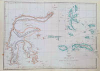
INDONESIA MAP OF SULAWESI & MALUKU ISLANDS WELLER EDWARD.
Celebes and the Molucca Islands.
London.: Weekly Dispatch Atlas. circa1860. Map with outline handcolour 31.3 x 43.3; 33.3 x 48.7 cms sheet 12 x 17 inches small marginal bloom not affecting the map in very good condition. Detailed mapping of these two island groups by Edward Weller 1819–1884 from the ‘Weekly Dispatch Atlas’ an atlas published in monthly instalments from 1855 for subscribers to the long running newspaper. Weller was a pioneer in lithography and was sought after for his skill in producing detailed and accurate maps. . Weekly Dispatch Atlas. unknown
Référence libraire : 184035
|
|
|
INDRE
Carte d?partementale en couleurs. 100x130cm. Repli?e. Sans date.
Carte seule, sans couverture.
|
|
|
INDRE-ET-LOIRE
Carte d?partementale au 1/189 000?. Sans date.
Une feuille repli?e. 56x75 cm.
|
|
|
INDRE-ET-LOIRE
Carte d?partementale au 1/200 000?. Sans date.
Une feuille 75x56 cm repli?e.
|
|
|
INDRE-ET-LOIRE
Carte routi?re d?partementale au 1/320 000? Carte offerte par la B. N. C. I.
1 feuille 57x38 cm.
|
|
|
Industrial Maps Supervised by Hiroyasu Funakubo and others
welfare engineering
Industrial Maps Supervised by Hiroyasu Funakubo and others 2002. Soft Cover. Fine. The book is in fine condition. Industrial Maps Supervised by Hiroyasu Funakubo and others paperback
Référence libraire : 2083002116200896
|
|
|
Ingram, Michael & Hurley, Graham
Moods of Surrey : A Photographic Essay of the County of Surrey in all Its Moods
Book in mint condition. Dust jacket not price clipped or marked or torn with traces of storage. 160pp. This book is the result of the enthusiastic response to a photographic competition and the quality and variety of pictures showed clearly the affection held by the people of Surrey for their County. The final selection accompanies text from Graham Hurley and captures the essence of Surrey in all its varying moods. Also comes with a signed personal letter from the Managing Director of one of the book's sponsors, L&C Croydon which congratulates the recipient on the purchase of their new BMW.

|
|
|
Inner Yamada Soro, Historical Maps Publisher
Yanagawa and Yanagawa people
Not Available 1978. Soft Cover. Fine. The book is in fine condition. Not Available paperback
Référence libraire : 2080502106904230
|
|
|
Innes-Smith, Robert (editor)
Derbyshire Guide
No marks or inscriptions. No creasing to covers or to spine. A very clean very tight copy with bright unmarked boards and no bumping to corners. Large fold-out map in perfect condition. 136pp. Includes a well-illustrated gazetteer to Derbyshire's towns and villages over nearly 100 pages.

|
|
|
InsideOut City Guide
London - Inside Out
London: Compass Maps 2002 Book. Fine. Hardcover. First Thus. Unique guidebook to London with pop-out maps. At the head of the spine is a compass to help get your bearings and inside is a small ballpoint pen for notetaking are both present and correct .Small size - only 17x10x1cm -easy to fit in a pocket. 84p. illus.col. NO copies found n Worldcat. Compass Maps hardcover
Référence libraire : 37596 ISBN : 1841398500 9781841398501
|
|
|
Institut Géographique National
CARTE "VIF 3 et 4"
Relevés de 1956, format 70 x 87 cm, bon état, en couleurs
Référence libraire : LFA00257
|
|
|
Institut géographique national
Carte de France au 1:50000 (Type 1922). ALTKIRCH. Feuille XXXVII-21. Publié en 1939.
Feuille de 58 (ht) x 73 (l) cm hors tout.
Référence libraire : 97826-CARTES
|
|
|
Institut géographique national
Carte de France au 1:50000 (Type 1922). BAUME-LES-DAMES. Feuille XXXIV-22. Publié en 1957.
Feuille de 58 (ht) x 73 (l) cm hors tout.
Référence libraire : 97825-CARTES
|
|
|
Institut géographique national
Carte de France au 1:50000 (Type 1922). BELFORT. Feuille XXXVI-21. Publié en 1948.
Feuille de 58 (ht) x 73 (l) cm hors tout.
Référence libraire : 97824-CARTES
|
|
|
Institut géographique national
Carte de France au 1:50000 (Type 1922). DELLE. Feuille XXXVI-22. Publié en 1945-1946.
Feuille de 58 (ht) x 73 (l) cm hors tout.
Référence libraire : 97823-CARTES
|
|
|
Institut géographique national
Carte de France au 1:50000 (Type 1922). FERRETTE. Feuille XXXVII-22. Publié en 1948.
Feuille de 58 (ht) x 73 (l) cm hors tout.
Référence libraire : 97822-CARTES
|
|
|
Institut géographique national
Carte de France au 1:50000 (Type 1922). LUXEUIL-LES-BAINS. Feuille XXXIV-20. Publié en 1957.
Feuille de 58 (ht) x 73 (l) cm hors tout.
Référence libraire : 97828-CARTES
|
|
|
Institut géographique national
Carte de France au 1:50000 (Type 1922). VESOUL. Feuille XXXIV-21. Publié en 1957.
Feuille de 58 (ht) x 73 (l) cm hors tout.
Référence libraire : 97827-CARTES
|
|
|
Institut Géographique National
CARTE n° 169 "CHAMBERY S.E."
Type 1889, révisée en 1897, format 53 x 75 cm, état moyen
Référence libraire : LFA00255
|
|
|
Institut Géographique National
CARTE n° 188 "VIZILLE"
Type 1889, édition de 1941, format 53 x 75 cm, état moyen
Référence libraire : LFA00253
|
|
|
INTERAVIA.
Réseau aérien d'Europe - European air routes - Europa-Luftverkehr 1939.
Genève, Interavia S.A., 1938. 388 x 353 mm.
Référence libraire : LBW-8615

|
|
|
International Travel maps
1. Bavaria and Munich/Munchen Travel Ref Map 1: 500K/10K
map. Good. Access codes and supplements are not guaranteed with used items. May be an ex-library book. unknown
Référence libraire : 1553415809.G ISBN : 1553415809 9781553415800

|
|
|
International Travel maps
1. Beijing & The Great Wall Travel Reference Map 1:23k/280000- 2010
International Travel maps 1/1/2010 12:00:01 AM. map. Very Good. 0.1000 in x 9.5000 in x 3.9000 in. International Travel maps unknown
Référence libraire : 3TWDDA002LUM ISBN : 1553416015 9781553416012

|
|
|
International Travel maps
1. Botswana & Zimbabwe Travel Reference Map 1:15M/1:11M International Travel Maps
map. Good. Access codes and supplements are not guaranteed with used items. May be an ex-library book. unknown
Référence libraire : 1553411471.G ISBN : 1553411471 9781553411475

|
|
 Recevoir par e-mail
 Télécharger en PDF
 Flux RSS


