|
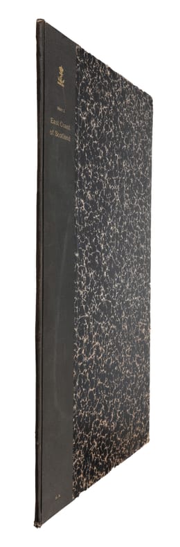
SEACHART SCOTLAND - JOHN MARR, JOHN THORNTON.
A New Description of the East Coast of Scotland from Berwick to Bokannais: Wherein is fully shewed the Chief Forelands, Bays, Roads, Rivers, Havens, Creeks, Sands, Shoals, Depths of Water and Anchoridg, with the Course of the Tides, and what Moon make...
(London, ca. 1810). Folio. (45 x 28 cm.). Later hcloth. Gilt lettering on upper cover. 4 pp. in folio. + engraved map (44 x 52 cm.) Chart of the East Coast of Scotland Bu John Thornton. Left and right margins shaved (no loss of image). Light browning and a few brownspots.
Bookseller reference : 55309
|
|
|
MAP - ARCTIC REGIONS.
Geological Map of the Arctic. Prepared by the First International Symposium on Arctic Geology sponsored by the Alberta Society of Petroleum Geologists.
Calgarry - Alberta Canada, Symposium Committee, 1960. (102 x 115 cm.). Large colourprinted circular map of the Arctic Regions. Folded. Well-preserved.
Bookseller reference : 55325
|
|
|
NORD-POL KARTE - NORTH POLE MAP.
Neueste Handkarte der Gebiete um den Nordpol. Breiten- Massstab 1:20 000 000. Nach zuverlässige Quellen bearbeitet von A. Herrich.
Glogau, Carl Flemming (ca. 1900). Orig. printed clothbacked boards. Map in colour (42 x 48 cm.) inserted and folded.
Bookseller reference : 55490
|
|
|
MAP - AUSTRALIA - STÜLPNAGEL, F. v.
Festland von Australien und benachbarte Inseln.
(Gotha, Justus Perthes), 1841. Engraved map (35,5 x 43,5 cm.). Handcoloured in outline. Fine and clean.
Bookseller reference : 55741
|
|
|
MAP - AMERICA - ADOLF STIELER.
Der nordöstliche Theil der Vereinigten Staaten von Nord America Neue Bearbeitung von Ad.St. 1831.
(Gotha, Justus Perthes), 1831. Engraved map (34,5 x 43 cm.). Handcoloured in outline. Gestochen von Joh. Carl Ausfeld.
Bookseller reference : 55743
|
|
|
MAP - IRAN und TURAN - STÜLPNAGEL, F. v.
Iran und Turan (Persien, Afghanistan, Beludschistan, Turkestan). Neue Bearbeitung von F. v. Stülpnagel.
(Gotha, Justus Perthes), 1843. Engraved map (35,5 x 44 cm.). Handcoloured in outline.
Bookseller reference : 55747
|
|
|
MAP - GIBRALTAR.
Plan der Berühmten Vestung Gibraltar belagert von den Spaniern und Frantzosen seit Anno 1779.
(Frankfurt am M., um 1780). (36 x 26 cm.) Engraved handcoloured map/plan of Gibraltar with text and with insets of Southern Span and North Africa around Ceuta and Tanger. A stamp in upper left corner. I.M. Zell, sculp. (Johann Michael Zell)Some brownspots.
Bookseller reference : 55916
|
|
|
MAP - GIBRALTAR.
Nueba Vista Gibraltar. 1782.
Wien, L. Hochenleiter, um 1782. (22 x 37 cm.). Engraved map (bird-eye-view) with ships in the sea, fortification and bombardment. Text in Spanish. Mildly brownspotted.
Bookseller reference : 55917
|
|
|
CADIX -
Plan de la Ville de Cadix. Sa Baie, et ses Environs. Rédigé d'apres une Carte trés exacte et particulière
Milano, Chez Bettalli, (ca. 1810). (56 x 84 cm.). Large engraved plan of Cadix and surroundings, sectioned in 8 and mounted on linen. Handcoloured. Gravé en Milan par Louis Rados. Some faint scattered brownspots.
Bookseller reference : 56906
|
|
|
(LÖWENÖRN, P. (POUL) de). - SHETLAND ISLANDS.
Beretning om et forbedret Kaart over de Hetlandske Öer, tilligemed trende Blade med Landtoninger og et speciel Kaart over Valley-Sund paa Hetland. Udgivet fra det Kongelige Söe-Kaarte-Archiv 1787. (Description of a new improved chart of the Islands of...
Kiöbenhavn, Thiele, 1787. 4to. Originale blåmarmorerede omslag. Stempel på titelbladet. 16 pp., 4 kobberstukne plancher (3 foldede med landtoninger samt et kort). Rent velbevaret eksemplar på skrivepapir.
Bookseller reference : 56969
|
|
|
PURDY, JOHN.
The New Sailing Directory for the Coasts of Spain and Portugal, from Cape Finisterre to Cadiz, and Thence to the Eastward of Malaga: Composed to Accompany the Chart.
London, Laurie, 1839. 8vo. In contemporary blank wrappers with part of original printed wrapper pasted on. Stamp to front wrapper and title-page. Internally fine and clean. iv, 38 pp.
Bookseller reference : 57123
|
|
|
WOLFE, JAMES.
Sailing Directions for the Lower Shannon and the Lough Derg.
London, Admiralty, 1843 8vo. In recent half cloth with gilt stamp and lettering to front board. Small paper label pasted on to verso front board and two stamps to title-page. Internally fine and clean. 32 pp.
Bookseller reference : 57129
|
|
|
SØKORT - SØKORTARCHIVET (UDG.).
Store Belt (Samsøe Beltet). 1832. Rettet til 1848.
(København), KDSK (Kgl. Danske Søkort Archiv), 1848. Kobberstukket søkort (106 x 63 cm.). I original opsætning på lærred og monteret i 27 sektioner (9 x 3). Foldet og opbevaret i det originale marmorerede foderal. Ren og velbevaret.
Bookseller reference : 57654
|
|
|
MAP - BRAZIL. - EDWARD STANFORD.
Brazil from official and other Sources prepared in the international Bureau of the American Republics, Williams C. Fox, Director.
London, Edward Stanford, 1905. (95 x 95,5 cm.). A large lithographed map of Brazil, lithographed in colours, original linen-backed and folded in 35 sections. Folded in the original cloth-case with the original printed title-label preserved. A fine copy.
Bookseller reference : 57772
|
|
|
WESSEL, CASPAR. - ET HISTORISK KORT.
Den Nord=Østlige Fierdedeel af Siælland under det kongl: Videnskabernes Societets Direction ved rigtig Landmaaling optaget og ved trigonometriske samt astronomiske Operationer prövet. Reduceret og tegnet Aar 1768 af Caspar Wessel.
(København), 1771. (59 x 69 cm.). Kobberstukket kort over Nordøstsjælland. Opdelt i 24 sektioner og opsat på lærred således, at det ved foldning let kunne medbringes.
Bookseller reference : 58005
|
|
|
WESSEL, CASPAR.
Den syd østlige Fierdedeel af Siælland under det Kongl: Videnskabernes Societets Direction ved rigtig Landmaaling optaget og ved trigonometriske samt astronomiske Operationer prövet. Tegnet af C. Wessel. Aar 1770.
(København, 1771). (59 x 69 cm.). Kobberstukket kort over Sydøstsjælland fra Køge Bugt til den nordlige del af Møn. Opdelt i 24 sektioner og opsat på lærred således, at det ved foldning let kunne medbringes. Enkelte svage brunpletter.
Bookseller reference : 58006
|
|
|
"(FREEDEN, W. VON.)
On the Routes of Mail Steamers between the English Channel and New York.
(Washington : Government printing Office, 1873). 8vo. In later half cloth with the original wrappers pasted on to boards. From ""Mittheilungen aus der norddeutschen Seewarte"", von W. von Freeden. Abstract, translated from the ""Revue maritime et coloniale"". July, 1873. Stamp to front board and first leaf of text. 12 pp. + folded chart.
Bookseller reference : 58308
|
|
|
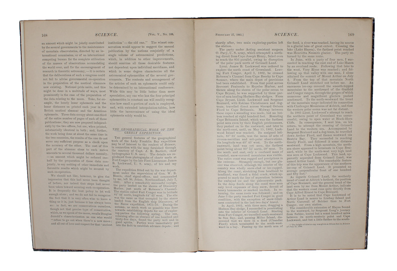
"GREELY, A. W. (+) FRANZ BOAS.
The Geographical Work of the Greely Expedition [Greely] (+) The Configuration of Grinnell Land and Ellesmere Land [Boas] (+) [Large folded map:] North America polar regions : Baffin Bay to Lincoln Sea, showing the most recent discoveries including tho... - [FIRST ACCOUNT OF THE LADY FRANKLIN BAY EXPEDITION]
(New York, 1885). 4to. In later half cloth with gilt lettering and stamp to front board. In ""Science"", Vol. 5, No. 108, Feb. 27. Paper label pasted on to front board. The two titles underlined in blue pencil. Stamp to verso of map and almost parted in two, long tear in foldings, otherwise internally fine and clean. Pp. iii-iv, 163-185 + large folded map: ""North America polar regions : Baffin Bay to Lincoln Sea, showing the most recent discoveries including those of U.S.S. Polaris Expedition in 1871-2, under Captain C.F. Hall, British Arctic Expedition in 1875-6, under Captain G.S. Nares, R.N., The Lady Franklin Bay Expedition in 1881-4, under Lieutenant A.W. Greely, U.S.A""
Bookseller reference : 58309
|
|
|
"BRUUN, DANIEL.
Generalstabens Opmaaling paa Island.
København, Det Schubotheske Forlag, 1905. 8vo. In contemporary board with the original printed front wrapper pasted on to front board. Stamp to front board and verso of front board. A fine copy. 20 pp + 3 coloured maps (of which one if folded).
Bookseller reference : 58605

|
|
|
BEAURAIN, JEAN de.
(Feldzüge des Marschalls von Luxemburg, oder Militärgeschichte von Flandern in den Jahren 1690-1694). Nur die 4 Kartentheile.
(Potsdam, 1783-85). 4to. (36 x 29 cm.). 4 portfolios in hcalf with ties. Gilt titlelabels on upper boards. Containing maps to all 4 campaigns. 64 (of 70 ?) folded maps in folio, partly handcoloured. Occasionally faint scattered brownspots, but generally clean.
Bookseller reference : 58667
|
|
|
BEAURAIN, JEAN de.
(Feldzüge des Marschalls von Luxemburg, oder Militärgeschichte von Flandern in den Jahren 1690-1694). Nur die 4 Kartentheile.
(Potsdam, 1783-85). 4to. (36 x 29 cm.). 4 portfolios in hcalf with ties. Gilt titlelabels on upper boards. Containing maps to all 4 campaigns. 64 (of 70 ?) folded maps in folio, partly handcoloured. Occasionally faint scattered brownspots, but generally clean.
Bookseller reference : 58727
|
|
|
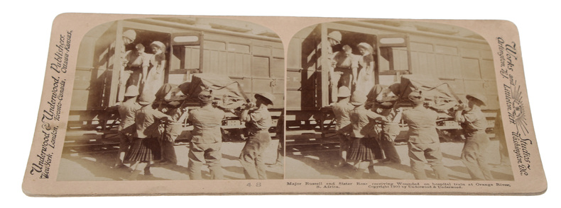
STEROSCOPE CARDS -
South African War through the Stereoscope. Vol. I-II.
Washington, Underwood & Underwood, 1900 - 1901. 72 stereoscope card (177 x 90 mm) housed in the original book-like slipcase. Slipcase with wear. Cards fine and clean.
Bookseller reference : 59848
|
|
|
EUGÈNE-HENRI FRICX
Table des cartes des Pays Bas et des frontieres de France, avec un recueil des plans des villes, siéges et batailles données entre les hauts allies et la France. - [ONE OF THE MOST IMPORTANT MAP PUBLISHERS IN THE SOUTHERN NETHERLANDS]
Brussels, 1712. Folio (512 x 315 mm). In contemporary half calf with seven raised bands. Spine and hindges with wear. Leather brittle and upper and lower 10 cm hindges detached. Two library labels pasted on to pasted down front end-paper. Upper margin of first three leaves blind-stamped. Handwritten (19th century hand) index mounted in on verso of first map and each map numbered. With 75 maps and plans, many double-page or folding: 24 cartes des Pays Bas, Carte générale de Brabant, Carte du Pays de Waes, Carte des Postes d'Allemagne, 48 plans des Villes, Sièges & Batailles (complete). 3 maps with minor marginal tear (outside plate), 2 with minor split to lower part of middle folding. A few maps at end with browning. A few plates (primarily 61, 50, 33, 25) heavily trimmed with slight loss to upper margin. An overall fine and clean copy.
Bookseller reference : 60165

|
|
|
CAPON GEORGES (NE EN 1890).
LES EXPOSITIONS UNIVERSELLES DE JADIS ET DE NAGUERE. PARIS. HOFFMANN-LA ROCHE.
SANS DATE (VERS 1935). SERIE DE 5 CARTES POSTALES VERTICALES REPLIEES, FORMAT 10,5 X 15 CENTIMETRES ENVIRON, ILLUSTREES D'UNE COMPOSITION EN COULEURS. 1855. 1867. 1878 (LES SOUKS ALGERIENS DANS LES JARDINS DU TROCADERO). 1900. 1931 (EXPOSITION COLONIALE. LA PROMENADE A DOS DE CHAMEAU DANS L'ENCEINTE DU PAVILLON DE L'AEF). BON ETAT.
Bookseller reference : 685
|
|
|
NEUDIN GERARD ET JOELLE.
L'OFFICIEL INTERNATIONAL DES CARTES POSTALES DE COLLECTION. PARIS. NEUDIN. 1985.
1985 1985 IN-8 BROCHE (15,5 X 22 CENTIMETRES ENVIRON) DE 542 PAGES, COUVERTURE ROUGE ILLUSTREE EN COULEURS.
Bookseller reference : 1568
|
|
|
HERALD (George W.) et RADIN (Edward D).
Monte-Carlo : Un siècle de roulette.
Paris, Trévise, Collection "Le dessous des cartes", 1964 ; in-8, broché, couverture illustrée, 265 pp.
Bookseller reference : 7437
|
|
|
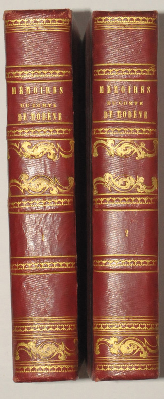
MODENE (Comte de).
Mémoires du Comte de MODENE, sur la Révolution de Naples de 1647. Troisième édition, publiée par J. - B. MIELLE.
Paris, Chez Félicien et Chatel, 1827. 2 volumes in-8, demi-chagrin rouge, dos ornés de filets dorés, 270 et 514 pages.
Bookseller reference : 7488
|
|
|
VERAME Jean.
Les merveilleuses cartes à jouer du XIXè siècle.
Paris, Nathan, 1989. Grand in-4 : cartonnage noir bradel, titre en rouge en long, bien complet de sa jaquette illustrée, gardes illustrées (cartes en couleurs).
Bookseller reference : 20231
|
|
|
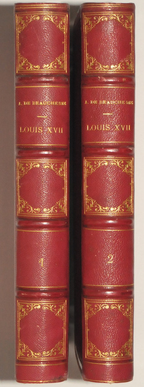
BEAUCHESNE A de.
LOUIS XVII. Sa vie, - Son agonie. - Sa mort. Captivité de la Famille Royale au Temple. Quatrième édition, enrichie d'autographes et de plans ornée de portraits gravés en taille-douce sous la direction de M. Henriquel Dupont et précédée d'une Lettre de Mgr Dupanloup évêque d'Orléans.
Paris, Henri Plon, 1867. 2 volumes grands in-8, 613 et 532 pp, plus table des matière dans chaque volume et placement des gravures et des autographes. Demi-chagrin rouge, dos à 4 nerfs, caissons ornés et filets dorés, tranches dorées. Belle reliure.
Bookseller reference : 24447
|
|
|
[IGN]
CARTE IGN n° 50 : SAINT-ETIENNE - LE PUY-en-VELAY
Une carte série verte au 1:100.000e, éditée en 1999, IGN, bon état
Bookseller reference : LFA-126750291
|
|
|
[Michelin]
CARTE MICHELIN : SUISSE
Une carte au 1:400.000e, éditée en 1978, Michelin, bon état
Bookseller reference : LFA-126750294
|
|
|
[IGN]
CARTE IGN RHONE-ALPES
Une carte routière et touristique R14 au 1:250.000e, éditée en 2009, Michelin, bon état
Bookseller reference : LFA-126750290
|
|
|
[IGN]
CARTE IGN D73-74 : SAVOIE, HAUTE-SAVOIE
Une carte départementale routière et touristique au 1:150.000e, éditée en 2018, IGN, bon état
Bookseller reference : LFA-126750292
|
|
|
[Michelin]
CARTE MICHELIN : RHÔNE-ALPES
Une carte au 1:200.000e, éditée en 2012, Michelin, bon état
Bookseller reference : LFA-126750293
|
|
|
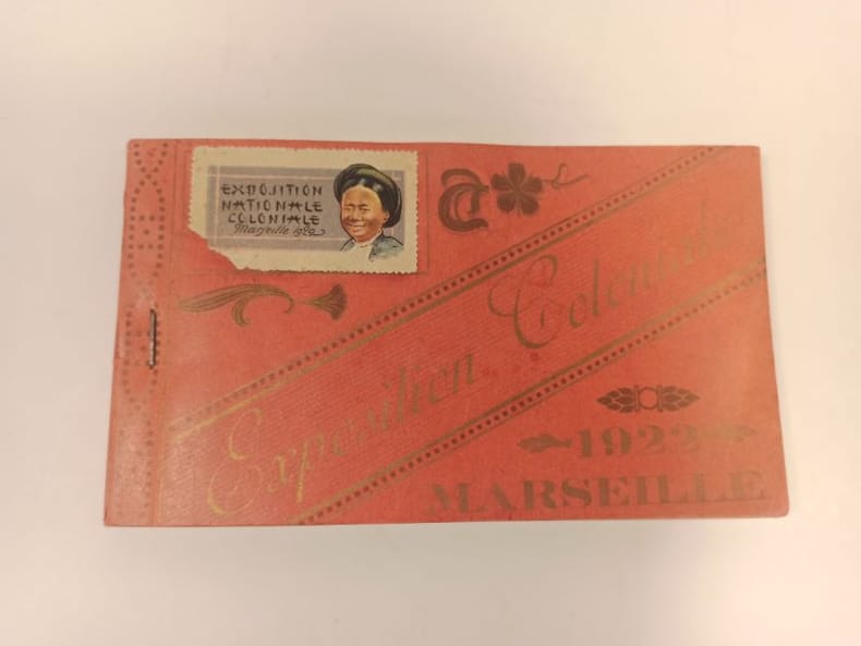
EXPOSITION COLONIALE)
Carnet complet de 24 poastales éditées à l'occasion de l'exposition coloniale de 1922, à Marseille.
1922 Format oblong broché (90 x 155 mmn) couverture rouge imprimée.
Bookseller reference : 23662
|
|
|
ROSSEL A- VIDAL J
DECOUVERTE DE L'AUVERGNE
Hier et demain ,1972, gr in folio en feuilles sous emboitage rouge éditeur. Tirage limité à 799 ex numérotés. 47 planches dont de nombreuses couleurs. Reproduction de grande qualité de cartes,lithos ,gravures ,pour la plupart introuvables,du XVè au XIXè siècle.
Bookseller reference : ML171
|
|
|
*
NORTHERN PROVINCES OF UNITED STATES
Thomsons (1871) carte coloriée 50cmx 59cm. Excellent etat Langue: Français
Bookseller reference : ML196
|
|
|
PASTOUREAU Mireille
Voies Océanes de l' Ancien au Nouveau Monde.
P, Editions Hervas,1990, in4° reliure éditeur; 185pp, 164 illustrations. Une histoire de la cartographie des deux Indes par la Spécialiste du sujet. Indispensable et, .passionnant .!
Bookseller reference : M3569
|
|
|
CLAPHAM H
Monte Carlo up to Date. With four entirely original methods of play, the only ones that can succeed under the present changed rules.
Slnd, in8br, 48pp , mouillures sur la couverture et quelques pages.
Bookseller reference : M5094
|
|
|
*
Lettres édifiantes et curieuses écrites des Missions étrangères. Mémoires du Levant - Tome troisième.
Lyon, Vernarel- Cabin 1819, in8 br , 492 pp , couverture défraichie avec manque de papier sur le dos Essentielement l' Egypte.
Bookseller reference : M12808
|
|
|
Golfe du Morbihan & Ile-aux-Moines à travers les cartes postales
Versailles , LGL , sd , in4° oblong , cartonné , 140 pp Abondantes reproductions. Ex dono .
Bookseller reference : M13918
|
|
|
GUILLOU - CHORON - LE BRETON - RANNOU.
PLEUBIAN ET LA PRESQU ' ILE SAUVAGE . Cartes postales et photos anciennes.
Pleubian et son passé , 1991 , in8 à l' italienne br ,
Bookseller reference : M14278
|
|
|
LEHIS Michel
LE CANTON DE VARADES EN 1900
D R , 1996 , grand in 8 broché , 212 pp. reproductions légendées de cartes postales anciennes. Envoi de l' auteur.
Bookseller reference : M15830
|
|
|
FRELAUT Bernard
IL Y A UN SIECLE LA BRETAGNE . La vie quotidienne des bretons.
Ouest France , 1999 , in4° relié , jaquette , 124 pp . Abondantes illustrations .
Bookseller reference : M15929
|
|
|
STEINMANN P / CANDIR R
HANSI A TRAVERS SES CARTES POSTALES 1895 - 1951
1996 Ed du Rhin , 1996 , in4° cartonnage ill éditeur , 191 pp . Près de 400 reproductions !
Bookseller reference : M16027
|
|
|
MENTELLE / CHANLAIRE
carte comparative des divisions anciennes et modernes du territoire actuel de la france.
A Paris chez les auteurs , an VI ( 1798 ) , carte de44 x 34 cm , contours et régions coloriées . Carte très interessante de par sa date et le propos des auteurs.
Bookseller reference : M16921
|
|
|
CONGRETEL Serge.
LA VENDEE ILLUSTREE . Cartes postales de Vendée de 1895 à 1920 .
1980 Les sables , Doré , 1980 , in4° reliure toile verte illustrée éditeur , 237 illustrations. Couverture légèrement défraichie , un cahier déboité . Ex dono collectif.
Bookseller reference : M18588
|
|
|
CARTES ANCIENNES DE BRETAGNE
1988 1988 CARTES ANCIENNES DE BRETAGNE. Collection présentée par l' association "Saint Malo et la mer ". Tour des dames ,octobre-novembre 1988. In4° broché. Edition tapuscrite.
Bookseller reference : M164387
|
|
|
LECLERE M et Mme
Les cartes postales anciennes nous parlent de Lorient. Tome 7, Place st Louis - Place Bisson - Cours de la Bôve - Rue de la Comédie - Cours des Quais et rues voisines.
Les cartes postales anciennes nous parlent de Lorient. Tome 7, Place st Louis - Place Bisson - Cours de la Bôve - Rue de la Comédie - Cours des Quais et rues voisines.Chez l'auteur, 1996 , in4°(21x30) broché,64pp.Abondantes illustrations.
Bookseller reference : 165871

|
|
|
LECLERE M et Mme
Les cartes postales anciennes nous parlent de Lorient. Tome 8 . Rue des Fontaines - Rue du Port - Rue de la Patrie - Place de Ploemeur - Place Alsace Lorraine..
Les cartes postales anciennes nous parlent de Lorient. Tome 8 . Rue des Fontaines - Rue du Port - Rue de la Patrie - Place de Ploemeur - Place Alsace Lorraine..Chez l'auteur, 1997 , in4°(21x30) broché,72pp.Abondantes illustrations...
Bookseller reference : 165872

|
|
 Receive by email
 Download as PDF document
 RSS feed


