|
BLAEU (Johannes);MORTIER (Pierre);
[POUZZOLES] Puteolanus ager. Le golfe de Pouzol et une partie du golfe de Naples elle est vers la ville de Pouzol, & les ruines des Baies.
Amsterdam Pierre Mortier 1704 406 x 510 mm.
Bookseller reference : LBW00281

|
|
|
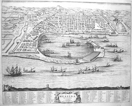
BLAEU (Johannes);MORTIER (Pierre);
[MESSINE] Messina ville de la Sicile.
Amsterdam Pierre Mortier 1704 414 x 522 mm.
Bookseller reference : LBW00282
|
|
|
VALENCIENNES. MANUSCRIT.
[Valenciennes].
circa 1760 498 x 1070 mm.
Bookseller reference : LBW00283

|
|
|
ISENRING (Johann Baptist);
Ansicht der Stadt Zurich und der innern Theile derselben - Vue de la ville de Zurich et de ses parties intérieures.
St. Gallen J.B. Isenring circa 1840 400 x 490 mm.
Bookseller reference : LBW00284
|
|
|
BRAUN (Georg);HOGENBERG (Frans);
[COSTUMES] Diversi Dithmarsorum et vicinarum gentium habitus.
Cologne 1598 362 x 495 mm.
Bookseller reference : LBW0028b

|
|
|
LE ROUGE (Georges-Louis);
Plan de Gênes.
Paris Sr. Le Rouge [1754] 308 x 463 mm.
Bookseller reference : LBW0028d

|
|
|
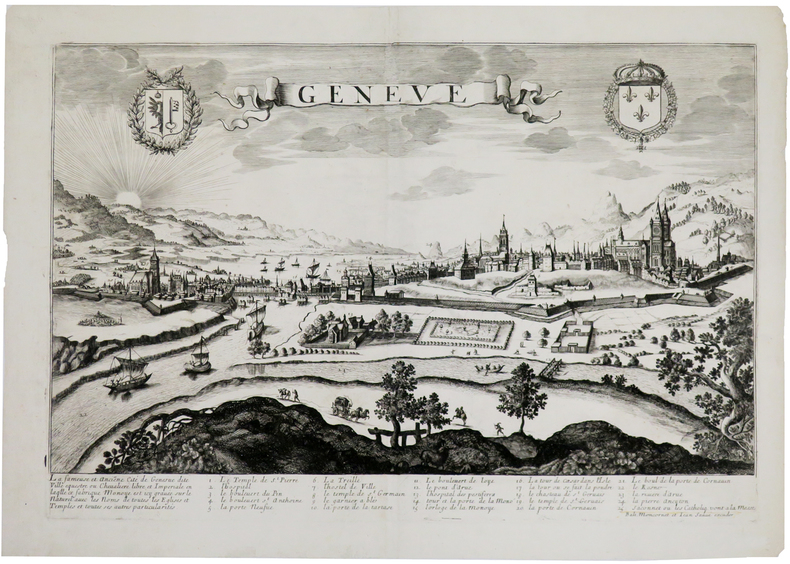
MONCORNET (Balthazar).
Genève.
[circa 1660]. 343 x 511 mm.
Bookseller reference : LBW0028e
|
|
|
TARDIEU (Nicolas Henri) & MENESTRIER (Claude-François).
[LYONNAIS] Carte de l'ancienne ville de Lyon.
[1696]. En 2 feuilles pouvant être jointes et former un plan d'environ 660 x 860 mm.
Bookseller reference : LBW00291

|
|
|
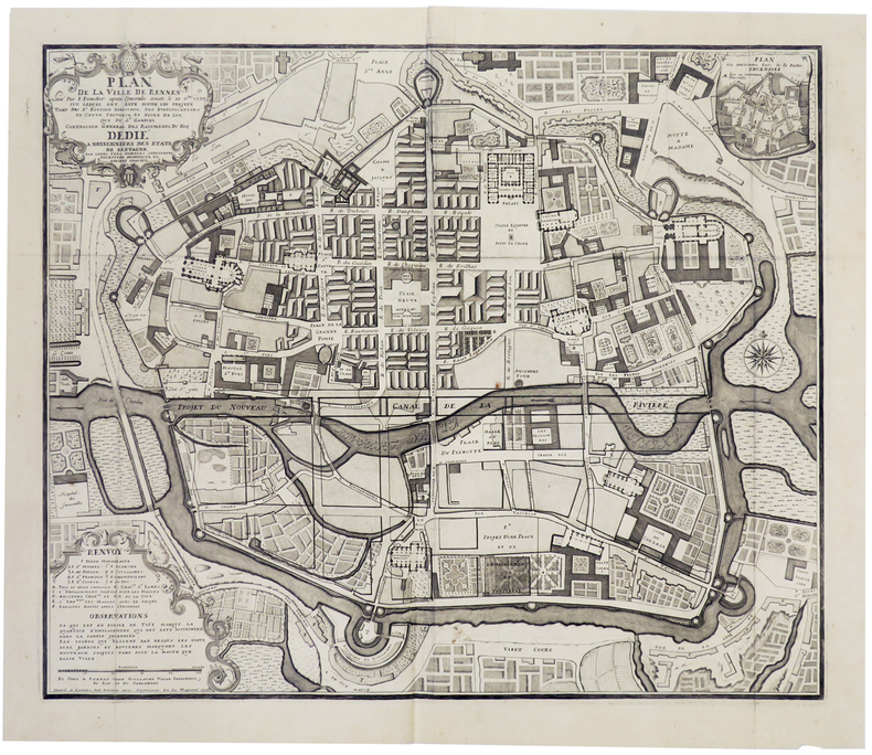
FORESTIER (F.).
[RENNES] Plan de la ville de Rennes levé par F. Forestier après l'incendie arivée le 22 xbre 1720, sur lequel ont esté formé les projets tant du Sr. Robelin Directeur des fortifications de cette province, et signé de luy, que du Sr. Gabriel Contrôleur Général des Bâtiments du Roy.
Rennes, Guillaume Vatar, 1726. 510 x 611 mm.
Bookseller reference : LBW00292
|
|
|
JOLLAIN (Gérard);
[BRETAGNE] Rennes.
Paris Jollain circa 1680 383 x 512 mm.
Bookseller reference : LBW00294
|
|
|
FER (Nicolas de);
L'Italie.
Paris chez l'auteur 1700 220 x 328 mm.
Bookseller reference : LBW0029b
|
|
|
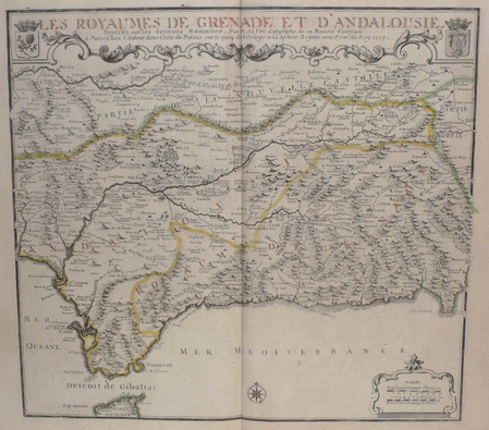
FER (Nicolas de);
[ESPAGNE] Les royaumes de Grenade et d'Andalousie.
Paris chez l'auteur 1707 443 x 483 mm.
Bookseller reference : LBW0029c
|
|
|
AYROUARD (Jacques).
[ANZIO] Plan du port d'Ancio.
[circa 1730]. 298 x 456 mm.
Bookseller reference : LBW0029d

|
|
|
MICHELOT & BREMOND;
[ELBE] Plan de Porto Ferraro en l'isle de l'Elbe.
1730 178 x 255 mm.
Bookseller reference : LBW002a2
|
|
|
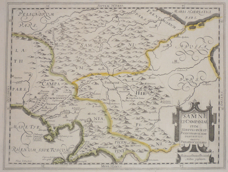
CLUVER (Philippe).
[CAMPANIE] Samni, et Campaniae, item Hirpinorum et Picentinorum agri descriptio.
[1624]. 206 x 273 mm.
Bookseller reference : LBW002a9
|
|
|
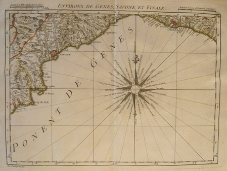
DHEULLAND (Guillaume);
[GENES] Environs de Gênes, Savone, et Finale.
Paris 1748 230 x 310 mm.
Bookseller reference : LBW002ac
|
|
|
DHEULLAND (Guillaume);
[BOBIO/PONTREMOLI] Environs de Bobio, et Pontremoli.
Paris 1748 230 x 310 mm.
Bookseller reference : LBW002ae
|
|
|
DHEULLAND (Guillaume);
[ALESSANDRIA/TORTONA] Environs d'Alessandrie, et de Tortone.
Paris 1748 230 x 310 mm.
Bookseller reference : LBW002af
|
|
|
DHEULLAND (Guillaume).
[NOVARE] Environs de Novare et de Mortara.
Paris, 1748. 230 x 310 mm.
Bookseller reference : LBW002b2
|
|
|
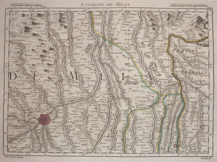
DHEULLAND (Guillaume);
[MILAN] Environs de Milan.
Paris 1748 230 x 310 mm.
Bookseller reference : LBW002b5
|
|
|
DHEULLAND (Guillaume).
[SESTO/BIAGRASSO] Environs de Sesto, et de Biagrasso.
Paris, 1748. 230 x 310 mm.
Bookseller reference : LBW002b8
|
|
|
FER (Nicolas de);
[NAPLES] Le royaume de Naples.
Paris chez l'auteur 1705 225 x 335 mm.
Bookseller reference : LBW002bb
|
|
|
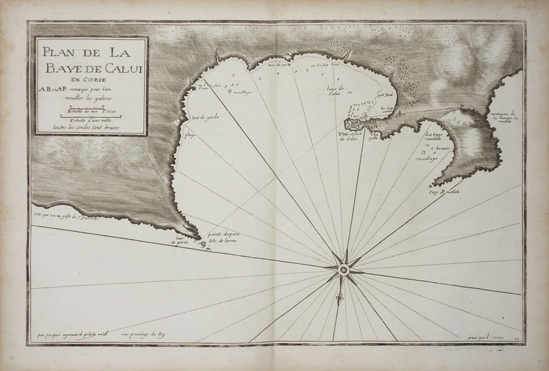
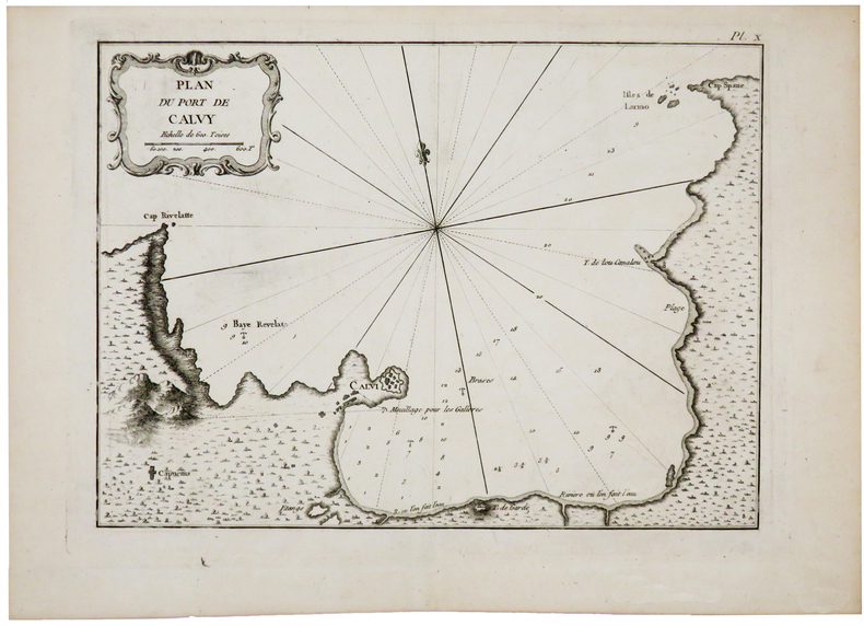
AYROUARD (Jacques).
[CORSE/CALVI] Plan de la baye de Calvi en Corse.
[circa 1730]. 287 x 450 mm.
Bookseller reference : LBW002c0
|
|
|
TARDIEU (Pierre François).
[KRONSTADT] Plan de Kronstadt.
[1794]. 216 x 308 mm.
Bookseller reference : LBW002c2
|
|
|
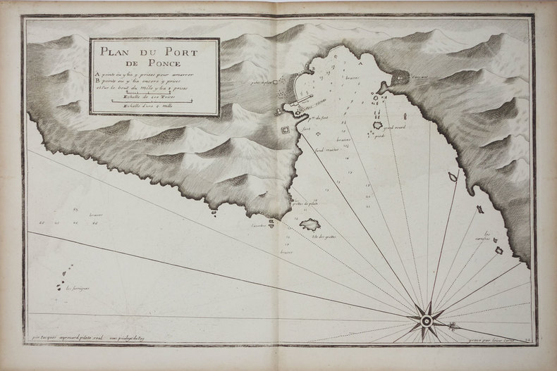
AYROUARD (Jacques).
[PONZA] Plan du port de Ponce.
[circa 1730]. 299 x 457 mm.
Bookseller reference : LBW002c9
|
|
|
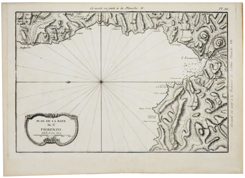
BELLIN (Jacques-Nicolas).
[CORSE] Plan de la baye de St. Fiorenzo.
[1769]. 216 x 322 mm.
Bookseller reference : LBW002cd
|
|
|
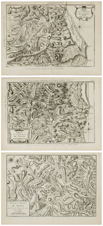
BELLIN (Jacques-Nicolas).
[CORSE] Partie de la province de Bastia. En trois feuilles.
[1769]. En trois feuilles d'environ 220 x 320 mm.
Bookseller reference : LBW002cf
|
|
|
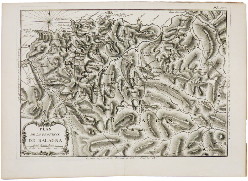
BELLIN (Jacques-Nicolas).
[CORSE] Plan de la province de Balagna.
[1769]. 222 x 310 mm.
Bookseller reference : LBW002d1
|
|
|
BELLIN (Jacques-Nicolas).
[CORSE] Plan du port de Calvy.
[1769]. 212 x 286 mm.
Bookseller reference : LBW002d2
|
|
|
BELLIN (Jacques-Nicolas).
[CORSE] Carte de la province d'Ajaccio et fief d'Istria en quatre feuilles.
[1769]. En quatre feuilles d'environ 230-240 x 275-300 mm.
Bookseller reference : LBW002d4

|
|
|
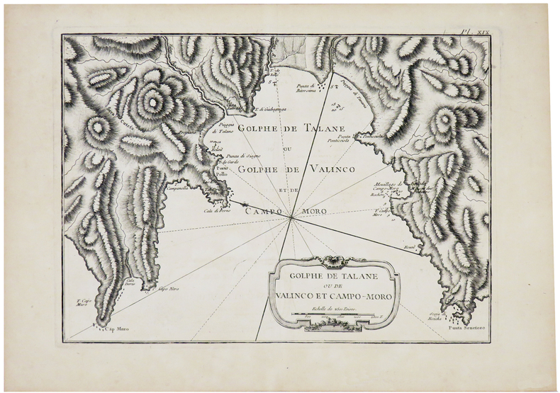
BELLIN (Jacques-Nicolas).
[CORSE] Golphe de Talane ou de Valinco et Campo-Moro.
[1769]. 210 x 288 mm.
Bookseller reference : LBW002d5
|
|
|
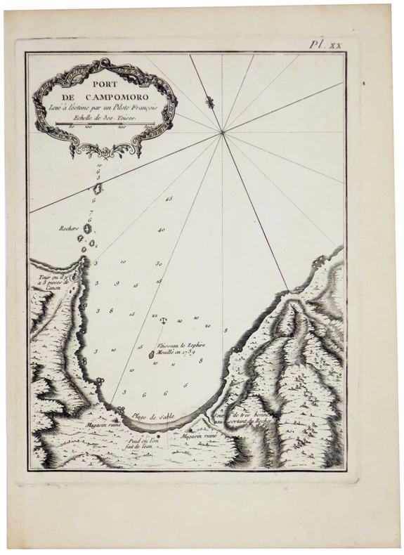
BELLIN (Jacques-Nicolas);
[CORSE] Port de Campomoro.
[1769]. 207 x 158 mm.
Bookseller reference : LBW002d6
|
|
|
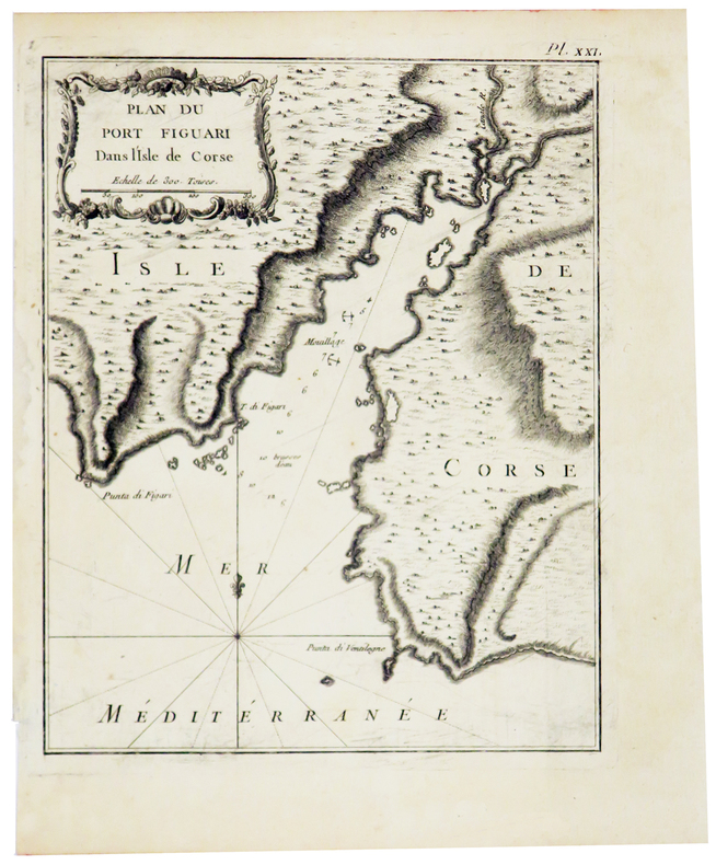
BELLIN (Jacques-Nicolas).
[CORSE] Plan du port Figuari dans l'isle de Corse.
[1769]. 218 x 177 mm.
Bookseller reference : LBW002d7
|
|
|
BELLIN (Jacques-Nicolas).
[CORSE] Plan du golfe de Ventilegne et partie de la coste jusqu'à Bonifacio.
[1769]. 222 x 310 mm.
Bookseller reference : LBW002d9

|
|
|
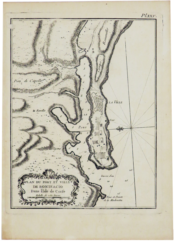
BELLIN (Jacques-Nicolas).
[CORSE] Plan du port et ville de Bonifacio dans l'isle de Corse.
[1769]. 212 x 163 mm.
Bookseller reference : LBW002da
|
|
|
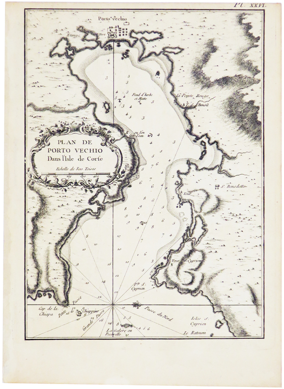
BELLIN (Jacques-Nicolas).
[CORSE] Plan de Porto Vechio dans l'isle de Corse.
[1769]. 229 x 167 mm.
Bookseller reference : LBW002db
|
|
|
BELLIN (Jacques-Nicolas).
[CORSE] Plan des bouches de Bonifacio et partie de la coste, depuis Porto Vecchio jusqu'à Bonifacio.
[1769]. 210 x 288 mm.
Bookseller reference : LBW002dc

|
|
|
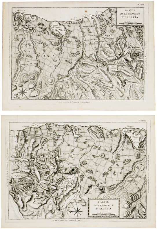
BELLIN (Jacques-Nicolas).
[CORSE] Partie de la province d'Alleria.
[1769]. En deux feuilles d'environ 225 x 325 mm.
Bookseller reference : LBW002dd
|
|
|
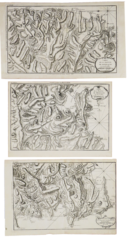
BELLIN (Jacques-Nicolas).
[CORSE] Carte de la province de Bonifacio en trois feuilles.
[1769]. En trois feuilles de 235 x 340-380 mm.
Bookseller reference : LBW002de
|
|
|
BELLIN (Jacques-Nicolas).
[CORSE] Plan de la ville de Corté dans l'isle de Corse.
[1769]. 218 x 177 mm.
Bookseller reference : LBW002e1

|
|
|
JOLLAIN (Gérard);
[LYONNAIS] Lyon.
Paris Jollain circa 1680 375 x 510 mm.
Bookseller reference : LBW002e3
|
|
|
***
National Geographic Society. MAPS. Washington, 1949 (Etats-Unis, Grands lacs, Canada, Pôle Nord, etc.)
Atlas des Etats-Unis formé de 11 cartes et leur index, les dix premières (USA historique et région par région) en étui, l'ensemble étant relié sous cartonnage toilé de l'éditeur.
Bookseller reference : 2678
|
|
|
Service de Tourisme Michelin
CARTE MICHELIN n° 90 "CORSE" Edition 1961
Une carte Michelin au 200 000éme, bon état
Bookseller reference : LFA0024c
|
|
|
Ch. VALLOT et E. de LARMINAT
CARTE GENERALE du MASSIF du MONT-BLANC
Carte Vallot au 1 / 50 000éme, édition de 1956, bon état, Editions Girard Barrère et Thomas (Paris)
Bookseller reference : LFA00251
|
|
|
Service Géographique de l'Armée
CARTE n° 178 "GRENOBLE S.E."
Type 1889, révisée en 1897, état moyen
Bookseller reference : LFA00252
|
|
|
Institut Géographique National
CARTE n° 188 "VIZILLE"
Type 1889, édition de 1941, format 53 x 75 cm, état moyen
Bookseller reference : LFA00253
|
|
|
Service Géographique de l'Armée
CARTE n° 178 "GRENOBLE"
Type 1889, révisée en 1897, format 53 x 75 cm, assez bon état
Bookseller reference : LFA00254
|
|
|
Institut Géographique National
CARTE n° 169 "CHAMBERY S.E."
Type 1889, révisée en 1897, format 53 x 75 cm, état moyen
Bookseller reference : LFA00255
|
|
|
Institut Géographique National
CARTE "VIF 3 et 4"
Relevés de 1956, format 70 x 87 cm, bon état, en couleurs
Bookseller reference : LFA00257
|
|
|
Collectif
CARTE-GUIDE CAMPBELL n° 9 "DAUPHINE"
Edition Blondel La Rougery, format 69 x 95 cm, échelle : 1 / 320 000éme, datant du milieu du XXe siècle, état moyen (nombreuses réparations au scotch)
Bookseller reference : LFA00259
|
|
 Receive by email
 Download as PDF document
 RSS feed


