Gulf Coast Ecosystem Restoration Task FoBiblio.com

4.355 Ergebnisse
2012Best.-Nr. SONG1619427818Brand: Nova Science Publishers Inc 2012-06-01. UK ed. hardcover. Used: Good. 7.25x0.75x10.00. Buy with confidence. Excellent Customer Service & Return policy. Brand: Nova Science Publishers, Inc hardcover
Best.-Nr. 3003Boston: The Company; Alfred Mudge & Son Printers 1878. . 8vo dusty pink wrappers front printed; some chips; slightly soiled One holding library in OCLC Boston: [The Company]; Alfred Mudge & Son, Printers, 1878. unknown
Best.-Nr. 2472Boston: The Company Alfred Mudge & son Printers 1878. . 8vo buff wrappers front printed some minor fragments missing from the bottom margin of the first few leaves not affecting text One holding library only in OCLC. Lists all capital expenditures for the year bridge building and other repairs; a breakdown of all shipments sent and the usual financial disclosures Boston: [The Company] Alfred Mudge & son Printers, 1878. unknown
Best.-Nr. 2472Boston: The Company Alfred Mudge & son Printers 1878. . 8vo buff wrappers front printed some minor fragments missing from the bottom margin of the first few leaves not affecting text One holding library only in OCLC. Lists all capital expenditures for the year bridge building and other repairs; a breakdown of all shipments sent and the usual financial disclosures Boston: [The Company] Alfred Mudge & son Printers, 1878. unknown books
Best.-Nr. 3003Boston: The Company; Alfred Mudge & Son Printers 1878. . 8vo dusty pink wrappers front printed; some chips; slightly soiled One holding library in OCLC Boston: [The Company]; Alfred Mudge & Son, Printers, 1878. unknown books
2014Best.-Nr. 1880733885Skybox Press 2014. First Edition. Hardcover. Very Good. May have limited writing in cover pages. Pages are unmarked. ~ ThriftBooks: Read More Spend Less.Dust jacket in good condition. First edition first printing. Minor shelf and handling wear overall a clean solid copy with minimal signs of use. Boards and dust jacket show slight signs of wear. All pages are intact binding is sound page block is crisp. Clean and unmarked. Secure packaging for safe delivery.Dust jacket quality is not guaranteed. Skybox Press hardcover
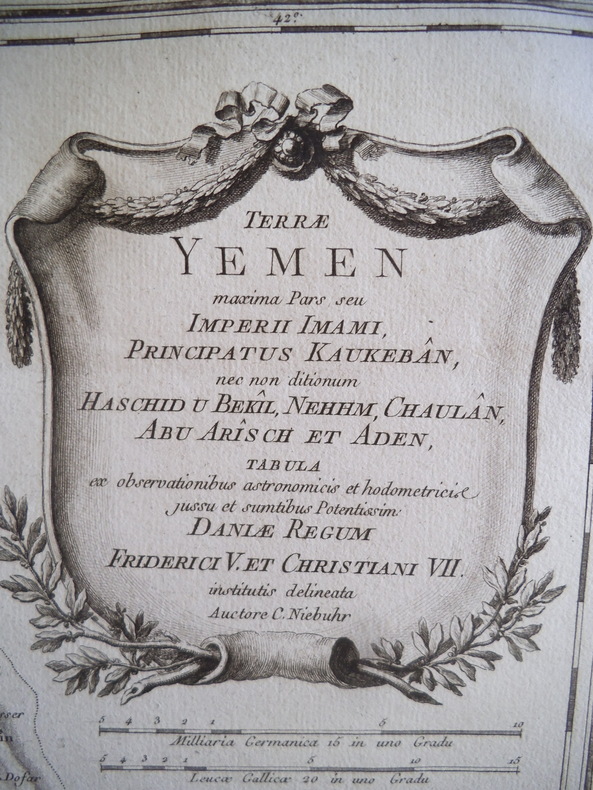
Best.-Nr. 14503CARSTEN NIEBUHR Terrae YEMEN maxima Pars Seu Imperii Imani Principatus Kaukebân nec non dilionum Haschid U Bkîl, Nehhm Chaulân Abu Arîs Ch et Aden. Tabua ex pbservtionibus astronomicis et hodometricise jussu et sumtibus Potentisissim Danlae Regum. Friderici V et Christaini VII Autore C NIEBUHR Carte 520x 670 mm avec marges, 380x580mm à la cuvette. Gravure sur cuivre d’après CARSTEN NIEBUHR, vers 1771. Né à Altendorf , ingénieur, mathématicien, et astronome allemand, membre d’une expédition Danoise de la péninsule du Sinaï au Yemen 1761 1767 dont il fut le seul survivant.
Best.-Nr. 135174aafParis, Chez Didot, 1747, in-8vo, XII + 532 p. Avec 6 vues et 5 cartes dépl., reliure en veau de l’époque, dos à cinq nerfs, pièce de titre en maroquin rouge, tranches rouges, bel exemplaire.
Best.-Nr. DADAX0415595215New unknown
1820Best.-Nr. 19314Paris Veuve Courcier 1820 Fort In-8 2 volumes en 1 tome 337 + 319 pp, une carte dépliante et trois lithographies. reliure moderne sobre mais pas de très bon goût néanmoins l'ouvrage est solide il était broché jusque là.
Best.-Nr. DADAX0419187901New unknown
1864Best.-Nr. 94849New Orleans 1864. Paperback. Very Good. 8 unnumbered pages. 21 cm. Modest foxing and some light staining on outer leaves. Small stitchmarks indicates that this was previously sewed. "Invalid Battalion Corps d'Afrique" printed in small type in upper left corner of first page. Authorized establishment of an Invalid battalion for the Corps d'Afrique to be composed of "colored" tropps who by reason of wounds or sickness contracted in the line of duty are unfit for further field service. Most of this rare general order reprints the War Department's General Orders Nos 105 dated 4.28/63 and 139 dated 5/15/63. Most of General Order 139 consisted of lists of physical infirmities that did or didn't disqualify soldiers from serving in the Invalid Corps. The final provision in General Order No. 139 states that no officer or enlisted man would be entitled to any pension premium or bounty for enlistment or service in the Invalid Corps although such soldiers would receive other pay and allowances authorized for the U.S Infantry. paperback
1864Best.-Nr. 94849New Orleans 1864. Paperback. Very Good. 8 unnumbered pages. 21 cm. Modest foxing and some light staining on outer leaves. Small stitchmarks indicates that this was previously sewed. "Invalid Battalion Corps d'Afrique" printed in small type in upper left corner of first page. Authorized establishment of an Invalid battalion for the Corps d'Afrique to be composed of "colored" tropps who by reason of wounds or sickness contracted in the line of duty are unfit for further field service. Most of this rare general order reprints the War Department's General Orders Nos 105 dated 4.28/63 and 139 dated 5/15/63. Most of General Order 139 consisted of lists of physical infirmities that did or didn't disqualify soldiers from serving in the Invalid Corps. The final provision in General Order No. 139 states that no officer or enlisted man would be entitled to any pension premium or bounty for enlistment or service in the Invalid Corps although such soldiers would receive other pay and allowances authorized for the U.S Infantry. paperback books
19098vo., First Edition [Sole Edition], with frontispiece and 14 plates; half-title and title lightly spotted; original green cloth, upper board and backstrip lettered in black, covers mildly age-marked, top lightly dust-soiled else a very good, clean copy. EXTREMELY SCARCE
1838Best.-Nr. 111804Cupar: G.S. Tullis and St Andrews Melville Fletcher Printed by G.S. Tullis Printer to the University of St Andrews 1838. 3rd Edition. Hardcover. Very Good. Cupar G.S. Tullis and St Andrews Melville Fletcher Printed by G.S. Tullis Printer to the University of St Andrews 1838 third edition/ 1807. Duodecimo xii last blank 264 pages with several tables plus 12 full-page engraved plates including an additional title page. Early gilt-decorated polished black calf all edges gilt endpapers marbled; top corners a little bumped with the extremities a little rubbed; light stain to the blank bottom corner of the last 40 leaves gradually reducing in extent from the rear and not affecting the printed surfaces; early ownership signature James Astle at the head of the engraved title page slightly cropped; a very good copy. Not least 'The Company of Golfers' pages 237-247. G.S. Tullis, and St Andrews, Melville Fletcher (Printed by G.S. Tullis, Printer to the University of St Andrews) hardcover
Oblong 4to. 12 black-and-white glossy prints. Spiral binding. Photo book of the Abqaiq Senior Staff School, an institute for the children of Aramco employees. The prints show the school building, the Aramco compound and petrol facilities, children playing softball, a swimming tournament, a falconer with his falcon, dromedars, a fishing boat, and a group of Arabs enjoying their coffee. With reproductions of the signatures of the class of 1961 to lower pastedown. - Edges somewhat worn.
2 pp. 8vo. Modern binder. Parliamentary minutes regarding the sale of a vacant site of some 4/5ths of an acre in the Manama district of Bahrain, originally acquired in 1903 for the erection of the Victoria Memorial Hospital which was demolished in 1953, to the Ruler of Bahrain, H.H. Sheikh Salman ibn Hamad Al Khalifa, who wished to found a Museum and Public Library on the site. The value of the site was estimated at about 70,000 pounds sterling. - With stamp of "The Law Society, London" (29 March 1957).
Standard issue, 710 x 1264 mm. Scale 1:24,300. Fine nautical chart of the port of Aden, historically a major hub of transportation for the region, prepared by the British Admiralty. Undoubtedly one of the better antiquarian maps of Aden under British administration. With a small panoramic view of the peninsulas of Aden and Little Aden. - The chart shows the Aden Peninsula with the city and harbour, as well as Little Aden peninsula and Bander Tauwahi. It details the port area, labeling the clock tower, the market, the cemetery, the Prince of Wales pier, police lines and telegraph stations, as well as Marbut Hill, Chapel Hill and Barrack Hill. It includes the mountainous Aden Peninsula and Gold Mohur Valley, as well as smaller islands such as Flint Island, Slave Island, and Sirah. On Little Aden the chart includes the Sheikh Ghadir temple as well as Mount Sugarloaf. In addition, the chart marks a quarantine area between both peninsulas for sea-going vessels. - The British Admiralty has produced nautical charts since 1795 under the auspices of the United Kingdom Hydrographic Office (HO). Its main task was to provide the Royal Navy with navigational products and service, but since 1821 it has also sold charts to the public. The present chart was composed after Admiralty surveys of 1906; it was first published in 1907 and saw several corrections up to 1936. - With two folds. A few manuscript notes. Slightly brownstained.
Standard issue, 710 x 1160 mm. Nautical chart of the Gulf of Suez from Suez to the Strait of Jabal, prepared by the British Admiralty. With two inset maps of the Ras Gharib anchorage and Abu Zenima Bay, as well as views of the Zafara and Ras Gharib lighthouses and the Sinai mountains with Mount Catherine. - The chart shows the Bay of Suez with the ports of Ibrahim and Thewfik and the maritime canal, as well as the Atakah mountains, the Zafarana plain and Mount Sinai. Among the most prominent labelled cities are Suez, Zafara, Abu Zenima, Ras Gharib, and El Tor. - The British Admiralty has produced nautical charts since 1795 under the auspices of the United Kingdom Hydrographic Office (HO). Its main task was to provide the Royal Navy with navigational products and service, but since 1821 it has also sold charts to the public. The present chart was composed after Admiralty surveys of 1871-72; it was first published in 1873 and saw several corrections up to 1933. - With two folds. With a stamp "Increase 50%" near lower right corner. A few manuscript notes. Captioned in print and in a former collector's hand on verso. Faint marginal flaws, not touching image; somewhat spotted.
Standard issue, 700 x 1024 mm. Scale 1:10,000 and 1:25,000. Detailed nautical chart of Port Sudan, the primary port of Sudan, prepared by the British Admiralty. Undoubtedly one of the best maps of the young city, which was built between 1905 and 1909 by the administration of Anglo-Egyptian Sudan to replace Suakin. Both the city of Port Sudan as well as the approaches to Port Sudan are combined on a single sheet. - The chart details numerous mooring posts, the port police, cranes and the customs office, as well as dangerous coral reefs stretching across the entire shore of Port Sudan. It includes landmarks such as churches and mosques, the Governor's residence, the public garden, school, and hospital, as well as sports clubs and the Polo grounds. Another interesting detail is the "pilgrim quarantine enclosure" to the south of the city, as well as the Atbara and Port Sudan railway. In addition, the Approaches chart displays offshore features like the Wingate Reefs and the North Towartit Reef. - The British Admiralty has produced nautical charts since 1795 under the auspices of the United Kingdom Hydrographic Office (HO). Its main task was to provide the Royal Navy with navigational products and service, but since 1821 it has also sold charts to the public. The Port Sudan chart was composed after an Admiralty survey of 1904; it saw corrections in 1916 and 1920. The Approaches chart is the result of a 1927 survey carried out by HMS Endeavour. - With a single fold. A few manuscript notes; stamp "Increase 50%" to lower margin. Captioned on verso in two former collectors' hands.
Standard issue, 700 x 1025 mm. Scale 1:10,000 and 1:25,000. Detailed nautical chart of Port Sudan, the primary port of Sudan, prepared by the British Admiralty. Undoubtedly one of the best maps of the young city, which was built between 1905 and 1909 by the administration of Anglo-Egyptian Sudan to replace Suakin. Both the city of Port Sudan as well as the approaches to Port Sudan are combined on a single sheet. - The chart details numerous mooring posts, the port police, cranes and the customs office, as well as dangerous coral reefs stretching across the entire shore of Port Sudan. It includes landmarks such as churches and mosques, the Governor's residence, the public garden, school, and hospital, as well as sports clubs and the Polo grounds. Another interesting detail is the pipeline from the West to the South Town as well as the Atbara and Port Sudan railway. In addition, the Approaches chart displays offshore features like the Wingate Reefs and the North Towartit Reef. - The British Admiralty has produced nautical charts since 1795 under the auspices of the United Kingdom Hydrographic Office (HO). Its main task was to provide the Royal Navy with navigational products and service, but since 1821 it has also sold charts to the public. The Port Sudan chart was composed after an Admiralty survey of 1904; the Approaches chart is the result of a 1927 survey carried out by HMS Endeavour. The entire chart was first published in 1929 and saw several corrections up to 1937. - With a single fold. Captioned in print and in a former collector's hand on verso.
11 photographs printed as black and white halftone screen cards. Ca. 161 x 115 mm or the reverse. An official diplomatic Saudi visit to Egypt in the late 1940s or early 1950s. Two images show HRH King Ibn Saud, the others show Egyptian officers. - A few nicks or lightly bumped edges, but on the whole well preserved.
8vo. (10), 70, (6), (43 plates), (2), 106, (1) pp. With folding map frontispiece. Red leather-backed blue cloth. A guide to the treasury of Qur'ans in the Museum of Ancient Iran in Tehran, printed in Persian and illustrated with over forty black and white plates from photographs. The plates illustrate the range of time periods, decoration practices, and calligraphic styles represented in the museum's mid-century Qur'an collection. A folding map frontispiece shows a floor plan of the relevant gallery, with arrows helpfully indicating to an interested visitor which way to best take in the exhibits. - The Iran Bastan Museum, also called the Museum of Ancient Iran, falls under the umbrella of the Iran National Museum. However, it is housed in its own specially designed building in Tehran, and was in fact the first structure in Iran purpose-built to act as a museum: its large arched entryway and brickwork are representative of the famous arch of Taq-e Kasra of Ctesiphon and the ancient traditions of Persian brick construction. Today, the Iran Bastan Museum largely houses much earlier relics of Iran's past, such as Neolithic spear points and Sassanian artifacts, with other sites of the Iran National Museum taking up the focus on Muslim-era manuscripts. A scarce piece of literature on Qur'ans in 1940s Iranian museum collections. - Exterior lightly worn, but in good condition. Uncommon. OCLC 61120487.
Two hand-coloured wood-engraved views, ca. 28 x 19 cms each. Unframed with traces of former mounting. The pretty views show ships and the fort in Elphinstone Inlet (Khor Ash Sham, the inner inlet of Khasab Bay) at the tip of the Musandam Peninsula, which juts into the Strait of Hormuz, the narrow entry into the Arabian Gulf. The mountains of Musandam are seen towering in the distance. - Removed from The Illustrated London News, 8 July 1865, published when the connection of the UK's "Persian Gulf Telegraphic Cable" between Karachi and Ottoman telegraphic lines was achieved across the Musandam Peninsula. Well preserved.
8vo. 13 [instead of 17, lacking pp. 3-6], (1), 2, 386 pp. Contemporary half leather with coloured paper boards. Fourth volume only of the Ottoman military manual "Ta'limat al-'Askariya al-Mustajadda" ("Instructions for the New Model Army"), discussing firearms, guns and artillery in the Ottoman army. Translated from Turkish into Arabic by Captain Hasan Effendi Muzahhar with the assistance of his fellow officer Mohammed Effendi 'Abi'l Hasan. The title ("Gun Instructions - The Shishana") denotes an old Ottoman lock rifle produced mostly in Syria. - Binding severely rubbed and bumped; spine chipped; remains of old lending label on upper cover. Handwritten English note on flyleaf: "found in a tent at Tel-el-Kebir / 14 September 1882 / T. J. Jones". In the Battle of Tel El Kebir (13 Sept. 1882), fought near the Suez Canal, the British military defeated the Egyptian army led by Ahmed Urabi following an insurrection of Egyptian soldiers during the Anglo-Egyptian War.