[Arabian American Oil Company].MareMagnum
[Hormuz - Bellin, Nicolaus].MareMagnum
Das Eyland Ormus oder Jerun. No place, mid-18th c.
1900Engraving, 252 x 308 mm. Matted. Hormuz Island, near Qeshm Island in the Arabian Gulf. Cf. Al-Quasimi 175.
4.355 Ergebnisse
8vo. 2 United States passports. Passports of the Aramco employee Joseph John de Roule, packed with entrance visa stamps from his trips to Aramco facilities in the Middle East, including Lebanon, Saudi Arabia, Egypt, and Turkey, but also Hong Kong, Cyprus, and Denmark. - De Roule had been with Aramco since 1951, his first assignment being that of a craft specialist in Abqaiq. He was transferred to Dhahran in 1956, where he later retired with his wife. His 1964 passport includes a set of spare original black-and-white passport photographs in a rear pocket. - In very good condition.
88 x 100 cm. Original colour-printed map. Scale 1:6,000,000. Rare political map of the Middle East from the Cold War era, centred on the Arabian Peninsula and the Gulf region, but also comprising Egypt, Sudan, Ethiopia and Somalia, as well as Greece, Turkey and the Levant, Iraq, Iran, Pakistan, and Afghanistan. With Cyrillic titles and captions. - Small marginal flaws.
1900Engraving, 252 x 308 mm. Matted. Hormuz Island, near Qeshm Island in the Arabian Gulf. Cf. Al-Quasimi 175.
Photo reproduction of a painting, 95 x 130 mm, mounted on studio backboard (107 x 166 mm). Photo reproduction of Josef Arpád Koppay's painting of a lady falconer seated on a horse.
1320 x 865 mm. Scale 1:145,925. Nautical chart of the North Coast of Panama. Engraved chart, including tidal information, compass roses, soundings, seabed notations, currents, sandbanks, shoals, lighthouses and beacons picked out in yellow and red, inland elevations, detailing and buildings. First published in 1938, revised in 1948. Signs of contemporary use. Folded.
Standard issue, 698 x 1024 mm. Scale 1:6,120. Detailed nautical chart of the port of Aden, historically a major hub of transportation for the region, prepared by the British Admiralty. Undoubtedly one of the better antiquarian maps of Aden under British administration. - The chart details the port area, labelling the Hotel de l'Europe, churches, the post office, the American Consulate, Cunningham market, the Prince of Wales pier, coal wharfs and the Aden Coal Company, as well as Marbut Hill, Chapel Hill and Barrack Hill. It includes the mountainous Aden Peninsula and Gold Mohur Valley, as well as the quarantine station on Flint Island. - The British Admiralty has produced nautical charts since 1795 under the auspices of the United Kingdom Hydrographic Office (HO). Its main task was to provide the Royal Navy with navigational products and service, but since 1821 it has also sold charts to the public. The present chart was composed after Admiralty surveys between 1906 and 1936; it was first published in 1907 and saw several corrections up to 1937. - With a single fold. Captioned in print and in a former collector's hand on verso. Slightly brownstained near upper right corner and on lower right margin.
Standard issue, 814 x 1006 mm. Scale 1:712,000. Nautical chart of the Gulf of Aden including the Horn of Africa and Socotra Island, prepared by the British Admiralty. With three panoramic views featuring Ras Jard Hafún and its neighbouring hills. - The chart details the Arabian and African coasts, Abd al-Kuri, and the Socotra Islands. Among the major labeled places are Ras-al-Kalb, Mukalla, Shihr, and Ras Kusa'ir on the Arabian coast, as well as Ras Adado, Bandar Kassim, Alula, and Hafun on the African continent. The chart shows geological features, marking several limestone formations including Jebel Warsangeleh, and warns mariners of the somewhat outdated rendering of Cape Guardafui, and of approaching the eastern point of Socotra island during the south-west monsoon. - The British Admiralty has produced nautical charts since 1795 under the auspices of the United Kingdom Hydrographic Office (HO). Its main task was to provide the Royal Navy with navigational products and service, but since 1821 it has also sold charts to the public. The present chart was composed after surveys by the Indian navy as well as Admiralty surveys between 1836 and 1927; it was first published in 1886 and saw several corrections up to 1934. - Small marginal tear in the centrefold, pierced in one place. Slightly brownstained. Two folds. A few manuscript notes and stamp "Increase 50%" near lower right corner. Captioned in print and in a former collector's hand on verso.
Standard issue, 687 x 1024 mm. Scale 1:8,100. Detailed nautical chart of Port Sudan, the primary port of Sudan, prepared by the British Admiralty. Undoubtedly one of the best maps of the young city, which was built between 1905 and 1909 by the administration of Anglo-Egyptian Sudan to replace Suakin. - The chart details numerous mooring posts, the port police, cranes and the customs office, as well as dangerous coral reefs stretching across the entire shore of Port Sudan. It includes landmarks like churches and mosques, the Governor's residence, the public garden, school, and hospital, as well as sports clubs and the Polo ground. Another interesting detail is the "pilgrim quarantine enclosure" south of the city, as well as the Atbara and Port Sudan railway. - The British Admiralty has produced nautical charts since 1795 under the auspices of the United Kingdom Hydrographic Office (HO). Its main task was to provide the Royal Navy with navigational products and service, but since 1821 it has also sold charts to the public. The present chart was composed after Admiralty surveys of 1904; it was first published in 1905 and saw several corrections up to 1918. - With a single fold. Captioned in a former collector's hand on verso. Two small marginal tears, hardly touching image.
Folio. (4) pp. Disbound. The text of an engagement of Sultan Abdallah of Johanna (Anjouan, Comoros) to "protect any persons who may be rescued from slavery by the vessels of Her Britannic Majesty's navy". - Old stamp at the head of the title. Disbound from volume of parliamentary papers, otherwise as issued, title serving as the upper cover.
Colour-printed map. Ca. 65 x 52 cm. Scale 1:800,000. German military map of eastern Anatolia in the Ottoman Empire, produced by the Prussian Ordnance Survey near the end of the First World War and marked as "for operational use only". - Folded. Formerly in the collections of the Geographical Institute of the University of Berlin with 1940s stamp and shelfmark. OCLC 246429024.
12mo. 161-197 pp.; entire work: 221, (3) pp. With 3 folding engr. plates. Original printed wrappers. Rare German translation of Wellsted's account of Oman. J. R. Wellsted's short career was almost entirely devoted to the surveying of the Red Sea, Arabia and Oman, undertaken on a number of expeditions between 1830 and 1837. On board the surveying ship Palinurus he was the first European to set foot in the interior of Oman. Starting late in 1835 from the easternmost point of Oman, Wellsted made his way westward through the Ja`alan region to the Wahibah Sands and then struck north up the Wadi Batha to Samad. There he was joined by Lieutenant F. Whitelock, also of the Indian Navy, who had set out from Muscat later. Together they reached Nazwa, the ancient capital of Oman, and climbed the lower slopes of the Jabal al-Akhdhar, in central Oman. In January 1836 they arrived on the Al-Batinah coast and then turned west, recrossing the Hajar mountains and emerging on the edge of the Dhaharah, the rocky steppe that stretches west toward the Rub` al-Khali. - Somewhat foxed throughout. Uncut, untrimmed copy. OCLC 162829268.
4to. (40) pp. With numerous black-and-white photographic illustrations. Original printed wrappers. Stapled. Illustrated report of BP activities in 1956. It showcases the company's international agenda, including their involvment with the trans-Antarctic expedition of Vivian Ernest Fuchs, drilling tests at Fahud, Oman, the search for oil in Gambia, East Africa and France, the fight against the caterpillar plague in Germany, aviation service, and refinery visits, as well as operations in Iran, Kuwait, Denmark and Austria. - Punched holes. Margins slightly worn.
Engraved map, hand coloured in outline. 535 x 371 mm. An English version of D'Anville's famous nautical chart of the Gulf from 1776. Although Bahrain is depicted, the large peninsula of Qatar is notably absent, and the coast between Bahrain and Abu Dhabi is marked "This Coast is not known". Al-Qasimi (2nd ed.), p. 236.
19248vo. XII, 345, (1) pp. With frontispiece, folding map and 37 plates. Original giltstamped blue cloth. First British edition, printed in the U.S.A. This work, dedicated to Abdul Aziz bin Saud, one of the author's "best friends", catered to a Western public eager to learn about the Arab people and about Ibn Saud, whose military success against the Al-Rashidi and consolidation of control over the Nejd had brought him to international awareness. The following year, he would conquer the Hejaz. - Foxing and brownstaining to interior. Rear hinge split. Removed from the Times Book Club, London, with their inconspicuous bookplate on rear pastedown and contemporary accession stamp (2 July 1926). Macro, Bibliography of the Arabian Peninsula, 1134 (cites a 1923 London edition in error).
760 x 625 mm. Scale 1:500,000. With some notes in pencil. In excellent condition.
(2), 152 SS. Bedr. blaue Originalbroschur. 8vo. Sehr seltene persische Textausgabe des Diwans des Dichters Labid. Yusuf Diya (1829-1906), der acht Monate lang an der Wiener Orientalischen Akademie Arabisch gelehrt hatte, war Abgeordneter des türkischen Parlaments in Konstantinopel und 1870-76 sowie 1878-79 Bürgermeister von Jerusalem. - Minimal stockfleckig. Unbeschnittenes, unaufgeschnittenes Exemplar. Nur zwei Exemplare nachweisbar: Dänische Königliche Bibliothek sowie Nationalbibliothek Strasbourg. OCLC 475092069.
4to. (43)-77 pp., final blank page. With 16 numbered plates of photographic illustrations. Original printed wrappers bound within contemporary full cloth with giltstamped spine-title, signed by R. Numans. Scarce treatise on early medieval textiles produced in the Near East, investigating the relation between Sasanian and Egyptian art. The personal copy of Carl Johan Lamm with his bookplate to front pastedown. Contains detailed descriptions and images of 62 fragments of tapestry kept at the Stockholm National Museum, the Röhss Museum in Gothenburg, and the "Kulturen" museum in Lund. - Lamm studied archaeology at the University of Stockholm. He wrote about the glass excavated at Samarra in 1928 and became a leading scholar on Islamic arts and crafts, notably in glass and carpets. He was on the staff of the Stockholm Museum and taught at Uppsala University. - In near-mint condition. Offprint from vol. XXX of "Le Monde Oriental", a journal on oriental studies published in Uppsala from 1906. OCLC 82868449.
8vo. (40), 312, 53, (19) pp. With one folding plate. - (Bound with) II: Tarnow, Hermann / Weidner, Johann Joachim. Grammatica Hebraeo-Biblica, comprehendens etymologiam, syntaxin, eloquentiam [...]. Rostock, Nikolaus Schwiegerau, 1722. (8), 248, (16) pp. 19th century half calf over marbled boards with giltstamped spine and spine-label. First edition of the Hebrew grammar prepared by the most celebrated orientalist of his day. The Göttingen scholar Johann David Michaelis (1717-1791) was the leading expert on Hebrew philology and Biblical exegesis. The present work advocates a new approach to emancipating Hebrew philology from the Greek and Roman tradition of linguistics, discussing verbs before nouns, as opposed to traditional Latin grammars. Fürst dates the first edition to 1744, in apparent error for 1745. - II: First edition of this grammar of biblical Hebrew by the German Lutheran theologians J. J. Weidner (1672-1732) and H. Tarnow (1674-1741). - Extremities slightly rubbed; tiny portion of upper hinge chipped away. Paper evenly browned troughout; occasional light spotting. ADB XXI, 685-690. OCLC 258323863. Cf. Fürst II, 375 (1744 ed.). Goedeke IV, 221. Not in Smitskamp. - II: Fürst III, 410. VD 18, 13308904. OCLC 248815662. Not in Smitskamp.
Matted, framed and glazed (frame dimensions 570 x 505 mm). Pretty lithograph by the famous horse painter Carle Vernet (1758-1836), showing an Arabian horse getting prepared for the ride. - In very good condition.
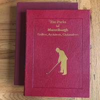
1991Best.-Nr. 3554907191371991. Hard Cover. Signed by Author. Droitwich Worcestershire: Grant Books 1991. AUTHOR'S PRESENTATION EDITION SIGNED BY THE AUTHOR JOHN ADAMS AND LIMITED TO 125 COPIES THIS BEING # 69. Publisher's full red morocco with gilt lettering to the front board and spine with vignette of a golfer in gold to the front board. Four raised bands to the spine. All edges gilt. Title to the spine in gilt on black leather label. Marbled end-papers. A very fine copy in like publisher's slip-case. Hand-written letter from the publisher dated 6.4.91 laid in about the forthcoming publication of this book. A stunning production. Note: This limited edition of 125 copies should not be confused with the separate limited edition of 750 copies which is signed by Shirley Grant the publisher which was NOT published with a slip-case. Photographs/scans available upon request. hardcover
Best.-Nr. DADAX0471599190New unknown
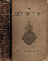
1892Best.-Nr. d2598Edinburgh: David Douglas. Covers rubbed with splits and small loss to head of spine. Contents frim and bright. 1892. Second Edition revised. Illustrated board covers with black leather spine. 230mm x 150mm 9" x 6". xx186pp. 20 photographic plates and 10 diagrams. . David Douglas hardcover
Best.-Nr. DADAX0367193736New unknown
Best.-Nr. DADAX0415075203New unknown
1957Best.-Nr. 355490719342London: Robert Hale 1957. First Edition. Hard Cover. Dust Jacket. First UK Edition. Publisher's black boards with title author and publisher in green and publisher's logo in silver to the spine. A bookseller's ticket to the front paste-down and just a touch of foxing to the page block edges otherwise a VG copy in like D/W. A very nice copy indeed. In the 1950's Robert Hale was primarily a library supplier hence why this publisher's first editions are so difficult to find in such nice shelvable condition. The novel features Tony Pearson a failed professional golfer in a novel that ticks all the noir boxes with frenetic pace and noir atmosphere laid on with a trowel in a tightly-constructed dark and paranoid entertaining novel famous for its golf content. A rare find indeed. Scans/photographs available upon request. Robert Hale hardcover