4.361 Ergebnisse
Standard issue, 700 x 1024 mm. Scale 1:175,000 approx. Nautical chart of a small portion of the Red Sea, the Bab-el-Mandeb Strait, prepared by the British Admiralty. It shows Perim Island and Halib Island, as well as Mokka as its northernmost city. Other notable places include Ras al Ara, Ras Bab-el-Mandeb, Khor Omeira, and the Jezirat Sowabih islands. The chart pays particular attention to geological features, labelling larger and smaller hills including the Jebel Arrar or Chimney Peaks, as well as dunes and sandy plains. - The British Admiralty has produced nautical charts since 1795 under the auspices of the United Kingdom Hydrographic Office (HO). Its main task was to provide the Royal Navy with navigational products and service, but since 1821 it has also sold charts to the public. The present chart was composed after Admiralty surveys of 1891, 1900 and 1901; it was first published in 1902 and saw several corrections up to 1936. - With a single fold. A few manuscript notes. Captioned in print and in a former collector's hand on verso.
Standard issue, 710 x 875 mm. Scale 1:36,370. Nautical chart of the Gulf of Suez from Suez southward to Ras el Ghubah on the African coast and Kad-el Towila on the Arabian coast, prepared by the British Admiralty. With small views of the light beacons on Kal ah Kebireh Shoal and Newport Rock lighthouse. - The chart shows the city of Suez, labelling hospitals, railway stations, cemeteries, the water works, and a mosque, as well as the maritime canal, Port Ibrahim and Port Thewfik. Other details include the plain of Atakah and the fresh water conduit from Atakah to Suez, the plains of Mohaggiara, and Oyun Musa, marked "the traditionary well of Moses". - The British Admiralty has produced nautical charts since 1795 under the auspices of the United Kingdom Hydrographic Office (HO). Its main task was to provide the Royal Navy with navigational products and service, but since 1821 it has also sold charts to the public. The present chart was composed after Admiralty surveys of 1870, and saw corrections following a 1927 survey carried out by the Suez Canal Company; it was first published in 1871 and saw several corrections up to 1931. - With a single fold. A few manuscript notes. With a stamp "Increase 50%" near lower right corner. Captioned in print and in a former collector's hand on verso. Small marginal tears in the centrefold; not touching image.
Standard issue, 710 x 864 mm. Various scales. Nautical chart of the northern Red Sea, showing the Sinai Peninsula, the Gulf of Suez and the Gulf of Aqaba, prepared by the British Admiralty. With 4 inset maps displaying the Tiran Island anchorage, Sherm Yahar, Sherm Jubba, and El Tor harbour. - The chart details major cities including Sharm-el-Sheikh, Hurghada, Aqaba, Magna, and Suez, as well as historic landmarks like Mowila fort. In addition, the chart warns the mariner of dangerous currents in the Red Sea as well as tidal streams in the Gulf of Suez. The inset map of El Tor harbour shows hospital buildings, a well of fresh water, pilgrims' baracks, mosques, ruins, and the camel track to Wadi Sillah. - With a small illustration of the Ashrafi lighthouse. - The British Admiralty has produced nautical charts since 1795 under the auspices of the United Kingdom Hydrographic Office (HO). Its main task was to provide the Royal Navy with navigational products and service, but since 1821 it has also sold charts to the public. The present chart was composed after Admiralty surveys of 1830-34 and 1911; it was first published in 1873 and saw several corrections up to 1931. - Small tear in lower margin, not touching image. Top margin slightly creased. A single fold; a few manuscript notes. With a stamp "Increase 50%" near lower right corner. Captioned in print and in a former collector's hand on verso.
1290 x 780 mm. Lithographed with some lighthouses highlighted in purple. Scale 1:883,200. Serial no. 1588. New edition of the U.S. Navy's 1899/1931 hydrographic map of the Gulf of Oman, immediately east of the Musandam Peninsula to Karachi, showing depths and lighthouses on the coasts of Oman and Iran. Marked as 8th edition, March 1948, reprinted April 1951. - Stamp of Northwest Instrument Co., Inc., Agents, Seattle, in lower margin. Well preserved.
Engraved chart. 760 x 1065 mm. Scale 1:23,594. Nautical chart including tidal information, compass roses, soundings, seabed notations, currents, sandbanks, shoals and inland elevations. Folded.
1320 x 865 mm. Scale 1:145,925. Nautical chart of the North Coast of Panama. Engraved chart, including tidal information, compass roses, soundings, seabed notations, currents, sandbanks, shoals, lighthouses and beacons picked out in yellow and red, inland elevations, detailing and buildings. First published in 1938, revised in 1948. Signs of contemporary use. Folded.
1147 x 850 mm. Scale 1:921,207. Engraved chart, including tidal information, compass roses, soundings, seabed notations. First published in 1898 from British Surveys to 1863. - Folded.
Engraved map. 1230 x 690 mm. Detailed British Admiralty chart of the approaches to Jeddah, present-day Saudi Arabia, with an inset chart of Jeddah Harbour and the city itself. - This is undoubtedly one of the better antiquarian maps of the gateway city to Mecca and Medina. Jeddah was an important diplomatic city when the map was made; illustrated are the consulates of Britain, Russia, Austria, the Netherlands, Egypt, and France. Numerous minarets of the old city are shown. The old city walls and the gates of Mecca, Cherif, and Medina are labeled. The Ummina Howwa (Eve's Tomb) is shown. - At the beginning of the 20th century, Jeddah was an important Red Sea port, but with many islands and much shoaling in the approaches, it was a dangerous one. The British Admiralty has produced nautical charts since 1795 under the auspices of the United Kingdom Hydrographic Office (HO). Its main task was to provide the Royal Navy with navigational products and service, but since 1821 it has also sold charts to the public. In 1795, King George III appointed Alexander Dalrymple, a pedantic geographer, to consolidate, catalogue, and improve the Royal Navy’s charts. He produced the first chart as the Hydrographer to the Admiralty in 1802. Dalrymple, known for his sticky personality, served until his death in 1808, when he was succeeded by Captain Thomas Hurd. The HO has been run by naval officers ever since. Hurd professionalized the office and increased its efficiency. He was succeeded by the Arctic explorer Captain William Parry in 1823. By 1825, the HO was offering over 700 charts and views for sale. Under Parry, the HO also began to participate in exploratory expeditions. The first was a joint French-Spanish-British trip to the South Atlantic, a voyage organized in part by the Royal Society of London. In 1829, Rear-Admiral Sir Francis Beaufort was appointed Hydrographer Royal. Under his management, the HO introduced the wind force scale named for him, as well as began issuing official tide tables (1833). It was under Beaufort that HMS Beagle completed several surveying missions, including its most famous voyage commanded by Captain FitzRoy with Charles Darwin onboard. When Beaufort retired in 1855, the HO had nearly two thousand charts in its catalogue. Later in the 19th century, the HO supported the Challenger expedition, which is credited with helping to found the discipline of oceanography. The HO participated in the International Meridian Conference which decided on the Greenwich Meridian as the Prime Meridian. Regulation and standardization of oceanic and navigational measures continued into the 20th century, with the HO participating at the first International Hydrographic Organization meeting in 1921. During World War II, the HO chart making facility moved to Taunton, the first purpose-built building it ever inhabited. In 1953, the first purpose-built survey ship went to sea, the HMS Vidal. Today, there is an entire class of survey vessels that make up the Royal Navy’s Hydrographic Squadron. The HO began to computerize their charts in the late 1960s and early 1970s. In 1968, the compilation staff also came to Taunton, and the HO continues to work from there today.
Standard issue, 700 x 1024 mm. Scale 1:50,000. Detailed nautical chart of the approaches to Mina Salman, the primary cargo port and customs point of Bahrain, prepared by the British Admiralty. Undoubtedly one of the better antiquarian maps of northern Bahrain. - The chart details the approaches to Mina Salman as well as the Sitra anchorage. Approach channels to Mina Salman were built in 1954, and a pier was constructed in 1956, mainly used by dhows. In 1958 it became a free port, and in 1962 a deep water wharf composed of six berths was constructed. The wharf allowed cargo to be directly loaded onto the port for the first time. In the 1960s, the port had refrigeration, storage facilities and equipment for handling large ships. - The map includes the cities of Muharraq and Manama, showing numerous minarets. Bahrain Fort, the Portuguese Fort, Abu Mahur Fort, and the Sheikh's palace are labelled. Another prominent site is Muharraq Airfield, a military base established by the Royal Air Force in April 1943 as RAF Bahrain (later RAF Muharraq) that remained in use until 1971, when Bahrain declared independence. - The British Admiralty has produced nautical charts since 1795 under the auspices of the United Kingdom Hydrographic Office (HO). Its main task was to provide the Royal Navy with navigational products and service, but since 1821 it has also sold charts to the public. The present chart was composed after Admiralty surveys from 1932 to 1960. The 1951 first edition saw revisions and corrections in 1962-65. - Very well preserved with a single fold. Provenance: stamps of Maria K. Iatrou, seller of nautical charts, books and instruments in Piraeus, Greece.
8vo. 14, (2) pp. With portrait frontispiece and folding Arabic facsimile. Original printed wrappers. Rare British pamphlet advertising the independence of Hejaz from Ottoman rule, following the Arab Revolt in which T. E. Lawrence had played so vital a role. Husayn strove for acknowledgement as "King of Arabia", though the powers would recognize him only as King of Hejaz. In 1924 Abd al-Aziz ibn Saud conquered Hejaz and proclaimed the Kingdom of Saudi Arabia six years later. - A clean, unmarked copy. Rare, the last copy at auction sold in 1999 (Sotheby's, Oct 14, 1999, lot 439, £800). OCLC 3949330.
Ink and watercolours on paper, backed with cloth. Calligraphic and armorial headpiece; historiated initials; two coloured illustrations (a hunter loading his gun; a hawk devouring a goose). Four red wax seals. 77 x 55 cms, rolled and stored in a contemporary marbled tube. A certificate of apprenticeship for the hunter Anton Spiallek (Spialleck) of Wiegstädtel near Opava in Silesia, signed by Franz Spialeck (possibly a relation) and four other district hunting officials of Dombrau and Mittel-Suchau (Prostrední Suchá), owned by Richard Baron Mattencloit. The art of hunting had long included falconry also in Silesia, and it was among the favourite pastimes of the nobility.
8vo. 9 pp. On three bifolia attached to one another with green string. A letter by a member of the British Consulate in Trieste, apparently written to a British official in Cyprus, responding to an enquiry regarding "the probable price of a pair of horses about 15 hands". "The kind of horses that you speak of are known here as 'Jukers', light, active, strong [...], fast trotting, able to go 14 kilometres an hour. A pair of horses of such description 5 years old & sound will cost about fls 1200 or say £100. Hungarian horses in my opinion will suit the best for your Island as they have Arab blood in them". The writer explains that he is not a dealer himself, "but being very fond of horses & having many native friends in India I have very often occasions to buy for them & also for my brother, who resides in Bombay at present". He explains that "no good horses are to be found in Trieste", and that "as a rule" he visits "the fairs in the interior" to buy horses. He names the four breeding farms of the Hungarian Government and describes the types of horses bred at each ("lastly the Fogaras stud, where stallions from the Lipizza private farm belonging to the Emperor are supplied"). Describes the auction of the "superfluous horses of these establishments of the age of 4 & 5" at "Tattersall's in Budapest in the 1st week of October", with prices for each type of horse, giving examples from his own experience. "Two British Cavalry officers belonging to the Egyptian Army came over here in the Autumn of 1896. They bought 60 remounts for the Egyptian cavalry. The Greek Cavalry & Artillery are wholly supplied with horses from Hungary". While discussing "sires for breeding purposes" he mentions that he knows "the Director of the Lipizza farm [...] personally" and gives the price at which he is offered superior horses by him. Ends with details of possible "charge for freight on each horse to Cyprus". - Text clear and complete.
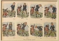
Best.-Nr. 120757-092Original 1920 lithography bookillustration of golfers on a golf course. A golfer and a caddy with golfclubs. Lithography 145 x 195 in a bigger cardboard passepartout total size 235 x 295 mm. Nice gift for a lover of Golf. The illustration depicts a golfers failed attempts at making a proper shot. The cartoons charming style and expressive sequence capture the lighthearted frustration of early golfing culture.NL Originele lithografie met een golfer en zijn caddy met de titel The Undriven Drive. Engelse bookillustratie. Stripvorm. Satirisch humoristisch. Leuk cadeau voor een liefhebber van golf. Vintage sportcartoon. unknown
4to (142 x 195 mm). Manuscript in Ottoman Turkish, 2 parts in one volume. (105), (38) pp. on (84) ff. Text in black (and occasional red) riqa', 15 lines within red (and occasional gilt) rules. 19th century limp brown morocco binding. A collection of two Ottoman Turkish treatises in a single 18th century manuscript, discussing the planting of trees and the cultivation of flowers. - Spine rebacked; altogether well preserved.
15 loose black leaves with b/w photographs (mostly 8” x 10”) and ephemera (letters, small advertising posters, telegrams, ticket stubs) adhered to rectos and versos; 20 photographs in all. Leaves quite brittle and chipped at the edges; some photographs a little wavy (from the adhesive) or creased, but for the most part clean, and always intelligible; large tear across one of the posters, fragile, but with no loss. Centered around a Carnival and Field Day, this collection features photographs of, or correspondence from, some famous characters: Tom Mix (an actor in early Western movies, who performed at the event), F. W. Blanchard (an early Los Angeles developer, first president of the Hollywood Bowl, and director of the event), Miss Hessie Hallett and her horse Arabjay (performers), James D. Phelan (politician, civic leader, and banker, who contributed personnel to the event), Kaiser Wilhelm II (photographed in the form of an effigy hung at the event), and William Taft (who, via telegram, regrets that he cannot attend). Offers a cursory glance at the event’s inner workings, with telegrams, special ticket stubs and lunch coupons for participants (offered by The Patriotic Mothers of Sons in Service), a copy of the program and list of organizers, and a typed financial statement. But the highlight - and focus - of the collection are the photographs of the beautiful horses that were featured in the rodeo events, races, and fancy mounts. A day-long extravaganza that included marching bands, military maneuvers, wrestling, boxing, tug-of-war, and more, this glimpse at a moment of grandstanding captures more than a singular event in California’s (and America’s) history, as whispers of the tumultuous time are discernable throughout.
Photo reproduction of a painting, 95 x 130 mm, mounted on studio backboard (107 x 166 mm). Photo reproduction of Josef Arpád Koppay's painting of a lady falconer seated on a horse.
Large 4to (208 x 260 mm). A series of 10 folding engraved plates of horses, all approx. 24 x 25 cm. Includes a board of iron and silver-plated hardware mounted on the front pastedown (34 pieces in all). Early 19th century half calf with marbled covers. The set includes 11 buckles (a twelfth appears to have been lost), 4 square rings, 9 bosses, and 6 ornamental appliqués, all of which are mounted on the inside upper cover with string or metal tongues and have identifying number codes in (faded) pencil. The plates show horses in five different tack kits, each presented for a single horse and for a team of two. A customer choosing from this sample book would first have picked a design from the plates, then selected the buckles and other hardware he wished to see used from the specimens inside the front cover. - Covers rubbed; extremeties bumped. A few ruststained holes and pressure marks to the front flyleaf and first plate; occasional slight staining to plates; lower corner of flyleaf is missing. A unique sample book used by an unidentified early 19th century tack maker.
2 albums containing a total of 49 large-format black-and-white prints (measuring up to 18 x 24 cm), some signed "Freund". Contemporary percaline (245 x 350 mm). High-quality photographs, mainly showing the winners of harness races driven by Harry Myrcik, including the horses Editor, Poldi, Aeolus, Burgschwester, Ester Cane, Norina, Cila, Fulklapp, Herbstwind, Cape Horn, Cedar, Ambrina, Akkord, Quarminus, Miami II, Sonnenmeister, Quintaner, Marie, and Oheim. Also, several offical finishing line photos and a few portraits. The collection is arranged chronologically; the 30 images in the first volume are tipped in, while the 19 in volume 2 are loose. Often, the image is captioned in calligraphy, citing the name of the winning horse and its owner, the measured time, the place and date of the race, etc., some signed by photographer (and stamped: "Foto - Freund, Berlin / Charlottenburg"). Most photos were taken at the Berlin's Mariendorf trotting course, founded in 1913 and revived in the 1960s after war damage was repaired. - Three smaller photos have been removed; otherwise perfect.
Albumen prints (vintage). Mostly 136 x 190 mm, but some smaller (down to 121 x 90 mm). Fine, rare collection of British equestrian sports in India, mostly showing the 1922 Calcutta Races. Annotated to rear: "The Indian Grand National: 1st Hurdle", "Mr Ivan Jones 'China Egg'", "The Canal Hurdle Plate (Finish)", etc. Also shows the spectators at a Polo match, portraits of Anglo-Arabian thoroughbreds, etc. - Steeplechase racing was popular in British India both among planters and cavalry regiments. The first Indian Grand National was run at Tollygunge as early as 1895. - Well preserved.
Collection of approximately 300 original betting cards, produced and intended for soliciting bets, sixty years before gambling was made legal. Three complete of sets of illustrated printed betting tickets, 100, 200, and 500 numbered series, respectively, each measuring 95 x 50 mm. Featuring an engraved illustration of English jockey Frederick Archer, a famously daring and successful Victorian rider who won most or possibly all of the great English turf prizes and accumulated a large fortune. Tickets are printed in Leeds, with stamp in bottom margin reading J. Richardson, "Bookmaker's Outfitter," Sporteries Leeds. Contained in the shoulder bag Charles Drew, English bookmaker who was arrested for charges of illegally soliciting bets on at least one occasion in 1901. Leather shoulder bag measuring 340 x 240 mm, with original strap, working clasps, inner pockets, his name in gilt to one side. Very good condition. Little is known of gambling bookie Charles Drew, but that his residence and business were based in South Shields, Tyne and Wear, in Northeast England, he married Ann Brown on 19 Jul 1852 at the South Shields St. Hilda parish church, and that he actively, illegally solicited gambling on streets by circulating betting cards for horse races. On 15 March 1901, the South Shields Daily Gazette reported on Drew's illegal activities: "At South Shields to-day, Charles Drew, bookmaker, was charged with betting East Street on Thursday last." Detective Sanderson and other officers deposed to the defendant being in the street taking bets in the usual way from 12 p.m. till 3 p.m. on the day named..." Several decades later, the gambling pastime which was already firmly entrenched in British culture would finally become a legal pastime. 1 September 1960, BBC: "1 January 1961 gambling for small sums will be legal for games of skill [...] betting shops will take gambling off the streets [...] At the moment, anyone who wants to place a bet on the horses has to demonstrate they have enough credit to set up an account with a bookmaker and do their dealings by telephone".
Altogether 12 items, various formats. Set of posters and programmes for horse races at Saintes, Marmande, Castillonnès (Lot-et-Garonne), Jonzac, Gémozac, Mirambeau, Mansle (Charente), Valence-d'Agen (Tarn-et-Garonne), Pons et Saujon. - Occasional damage to edges.
8vo. XVI, (97)-192, XVII-XX pp. With a folding map and a folding plate. Original printed wrappers. Includes the description of an early view of Hormuz Island, "A View of Ormus in 1627" (by William Foster, pp. 160-162), illustrated by a large folding plate. The sketch was drawn by David Davies, master's mate of the East India Company's ship "Discovery", but a few years after the island was captured by a combined Anglo-Persian force in 1622. - Slight foxing, otherwise fine.
1900Engraving, 252 x 308 mm. Matted. Hormuz Island, near Qeshm Island in the Arabian Gulf. Cf. Al-Quasimi 175.
Albumen prints on cardboard, dated on the reverse. Measurements 279:219 and 285:225 mm. The photographs show "Pilgrims entering Bethlehem on Christmas day" and an apparently English party of three tweed-clad gentlemen, one lady, a photographer-manservant, and two Arab guides posing before the Dead Sea. - The view of Bethlehem shows some fading and bears a caption the French and English, as well as the publisher's name, "Bonfils".
132 x 102 mm. Captioned on the reverse: "Holy Carpet + Tailors Who made it". - Traces of former mounting, but well preserved altogether.