[Oriental Porcelain and Ceramics].MareMagnum

4 355 résultats
Large folio (approx. 33 x 49 cm). (4), 41, (3) pp. With 58 plates (all with tissue guards; all edges gilt). Contemporary cloth portfolio. A fine set of plates, with extensive scholarly commentaries by three specialists, showing not only a wealth of Chinese and and Japanese, but also Arabic ceramics from Austrian princely and noble collection. The Middle-Eastern works are mainly in the Hispano-Mauric tradition of mediaeval Spain. Includes an illustrated essay by Josef Karabacek on Muslim ceramics. - Occasional slight foxing to wide margins of plates, otherwise well-preserved.
50 plates with 5 ff. of letterpress text. In original half cloth portfolio. Folio (340 x 465 mm). A fine collection of Arabic, Persian, and Ottoman as well as Indian and Asian decorated metal objects, including bowls, basins, water pitchers, and tea pots. Several separate plates show details of the elaborate ornamentation. - Some foxing; slight defects to portfolio flaps. Removed from the Vienna University of International Trade with their cancelled stamps on the portfolio. OCLC 3124615.
8vo. (16), 191, (1) pp. Contemporary black marbled wrappers. Rare first German edition of Galland's "Recueil des rits et cérémonies du pelerinage de la Mecque" (1754). Galland's account of the rituals surrounding the pilgrimage to Mekkah includes enlightening description of many of the important shrines and sites within the city. Extensive footnotes describe the history and physical appearance of such features as the Kaaba, the Black Stone, and Mount Ararat, as well as explaining relevant Arabic terms and the importance of certain religious figures in the Islamic tradition. The work also contains an extensive essay on the island of Chios, as well as a discussion of Ottoman science. "This very interesting work contains five separate essays. The first three are translations from Arabic and Turkish authorities; the last two are eye-witness accounts - one a long description of Chios and the other a description of the marriage of Sultana Esma with Yakub Pasha, governor of Silistria" (Navari). - Some occasional browning and foxing. Extremeties rubbed and bumped; untrimmed and uncut as issued. Not in Chauvin. Cf. Atabey 470. Blackmer 643.
réf. 68-5054San Jose CA: San Jose Golf And Country Club 1987. 4to. White Gilt Cloth 109 pp. Very Good. Color and B&W plates. Provenance: Everett Mathews attorney from Millbrae CA. San Jose, CA: San Jose Golf And Country Club, 1987. hardcover
réf. 88638Paris, Editions Karthala, 2001. 13 x 21, 202 pp., 4 cartes, quelques illustrations en couleurs, broché, très bon état.
Folio. 163, (19) pp., final blank f. With woodcut printer's device to title-page. - (Bound with) II: Hoffmeister, Johann. In XII priora capita actuum apostolicorum commentaria [...]. Cologne, Arnold Birckmanns heirs, 1567. (6) pp., 1 blank f., 225, (1) pp. With woodcut printer's device to title-page. Contemporary limp vellum with ms. spine title. Traces of ties. First edition of the history of the Saracens and Turks, dedicated to Emperor Maximilian II. The humanist C. A. Curio (1538-1567) thinks it likely that the Turks are descended from the Huns and shows skepticism toward theories that they might be descended from the Twelve Tribes of Israel, or, as Pliny had surmised, from the Tartars. Curio describes the Saracens as a people wrought by internal strife, often defeated and fragmented by the Arabs. - Bound within the same volume is a rare commentary on the first 12 chapters of the Acts of the Apostles by the Augustinian and theologian J. Hoffmeister (c. 1509-47). - Binding slightly loosened; some reinforcements to gutters; second word rather browned in places with occasional waterstains. A good copy of an important, early work on the Turkish people. I: VD 16 C, 6410 (D 2655). Göllner 1211. Adams C 3078. BM-STC German 232. Schottenloher 51906. Kutter A14, 1. - II: VD 16. H 4266. Not in Adams or BM-STC German.
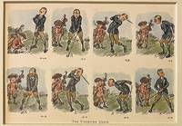
réf. 120757-092Original 1920 lithography bookillustration of golfers on a golf course. A golfer and a caddy with golfclubs. Lithography 145 x 195 in a bigger cardboard passepartout total size 235 x 295 mm. Nice gift for a lover of Golf. The illustration depicts a golfers failed attempts at making a proper shot. The cartoons charming style and expressive sequence capture the lighthearted frustration of early golfing culture.NL Originele lithografie met een golfer en zijn caddy met de titel The Undriven Drive. Engelse bookillustratie. Stripvorm. Satirisch humoristisch. Leuk cadeau voor een liefhebber van golf. Vintage sportcartoon. unknown
6 maps, colour printed. Scales: 1:100,000; 1:250,000; 1:2,500,000. All in their original printed orange and green envelopes, all but one with accompanying booklets. Six maps from the USGS's premier Geologic and Geoscience series (English and Arabic text), focusing on the west of the Arabian Peninsula. Originally compiled from field mapping carried out at the 1:100,000 scale, though scales here vary. Maps include keys and cross-sections, and sometimes an accompanying booklet of detailed explanatory notes. Comprises individually: - 1) GM-22 (IR 182; Vranas p. 17): Geology of the Jabal Ibrahim Quadrangle, Sheet 20 / 41C, by W. R. Greenwood, with a Section on Economic Geology, by R. G. Worl and W. R. Greenwood, 82 x 74 cm, 1:100,000, 1975 (1976). Based on mapping done Dec. 1970-Jan. 1971. With 18 pp. staple-bound illustrated notes as called for. - 2) GM-28: Geology of the Nuqrah Quadrangle, sheet 25E, by J. Delfour, 106 x 62 cm, 1:250,000, 1977. Includes 18 pp. staple-bound illustrated notes by J. Delfour. This area lies a little to the north of Medina. Original mapping is credited to the Bureau de Recherches Geologiques et des Minieres. - 3) GM-66 - Plate 2: Mineral locality maps of Saudi Arabia, by Hans van Daalhoff, 71 x 96 cm, 1:2,500,000, 1982. This map is a reduction of the Anglo-American / USGS Map I-270-B2 (1963) and includes a large stretch of the Red Sea coast including the Holy Sites, part of Qatar, and the major oil producing locations on the Arabian Gulf. - 4) GM-78A (IR 383; Vranas p. 33): Geologic map of the Najran quadrangle, Sheet 17G (with Landsat base), by Edward G. Sable, 109 x 64 cm, 1:250,000, 1985. Includes 18 pp. staple-bound illustrated "Explanatory Notes" by Sable as called for (though Vranas confusingly indicates this should also include an additional geographic map, and the booklet be 35 pp.). - 5) GM-122: Industrial mineral resources map of Jiddah, by C. H. Spencer, Alain Cartier, and Pierre Louis Vincent, in two sheets, 1988. 1:100,000. 2 sheets (Jiddah East; Jiddah West), each 102 x 76 cm. Includes 15 pp. staple-bound illustrated notes by Spencer, Cartier and Vincent. - 6) GM-132: Geologic map of the Cenozoic Lava field of Harrat Kishb, by M. John Roobol and Victor E. Camp, 86 x 76 cm, 1:250,000, 1991. Includes 34 pp. staple-bound illustrated notes by Roobol and Camp. - Very well preserved in general. G. J. Vranas, List of Interagency Reports submitted by the US Geological Survey Saudi Arabian Mission to the Saudi Arabian Directorate General of Mineral Resources from 1965 to the beginning of 1992 (Open File Report USGS-OF-92-2. Interagency Report 844 (Jiddah: Ministry of Petroleum and Mineral Resources Directorate General of Mineral Resources, 1412 AH/1992 AD), pp. 17, 33.
6 maps, 70 x 61 cm to ca. 75 x 65 cm. Printed in black and white. Constant ratio linear horizontal scale 1:4,000,000 scale. All in their original printed orange envelopes. Of the eight index maps produced during 1980-81, six are included here (wanting 100 [IR 400] and 107 [IR 407]). They feature the Arabian Peninsula, with labels for Mecca, Medina, Jeddah, Riyadh, Dammam, Sharjah, Masqat, Kuwayt etc. Comprises individually: - 101 (IR 401): Index Map of 1:250,000 scale quadrangle maps; 102 (IR 402): Index map of Landsat imagery of the Arabian Peninsula: Path 169 through 189, Row 38 through 51; 103 (IR 403): Index map of 1:50,000 scale mosaics, SAG and GSMO photography 1950-53; 104 (IR 404): Index map of 1:100,000 scale mosaics and photo maps, SAG and GSMO photography 1950-53; 105 (IR 405): Index map of 1:100,000 scale mosaics, WSA photography 1955-57; 106 (IR 406): Index map of 1:50,000 scale mosaics, WSA photography 1955-57. - In excellent condition throughout. G. J. Vranas, List of Interagency Reports submitted by the US Geological Survey Saudi Arabian Mission to the Saudi Arabian Directorate General of Mineral Resources from 1965 to the beginning of 1992 (Open File Report USGS-OF-92-2. Interagency Report 844 (Jiddah: Ministry of Petroleum and Mineral Resources Directorate General of Mineral Resources, 1412 AH/1992 AD), pp. 71, 35f.
20 maps, 84 x 53 cm or larger. Printed in brown tones. Transverse Mercator projection, constant ratio linear horizontal scale 1:250,000 scale. All but two in their original printed orange envelopes. The joint NASA/USGS Landsat Programme started in the early 1970s, providing the longest continuous space-based record of the Earth’s surface. Of the 25 maps in 1:250,000 scale produced during 1979-81, 20 are included here (wanting 2, 3, 4 [IR 301, 302, 303], 13 [IR 312], 16 [IR 315]). They cover the stretch of the Red Sea coast from just below the Gulf of Aqaba to just below Jeddah, and inland from Jeddah towards Dammam via Riyadh. Comprises individually: - 1 (IR 300): Jabal Al Hasir Quadrangle, Sheet 19F, 1979; 5 (IR 304): Jibal Hayil Quadrangle, Sheet 17E, 1980; 6 (IR 305): Al Qunfudhah Quadrangle, Sheet 19E, 1980; 7 (IR 306): Wadi Hali Quadrangle, Sheet 18E, 1980; 8 (IR 307): Jizan Quadrangle, Sheet 16F, 1980; 9 (IR 308): Jibal Al Qahr Quadrangle, Sheet 19G, 1981; 10 (IR 309): Bi’r Idimah Quadrangle, Sheet 18G, 1981; 11 (IR 310): Jaza’ir Farasan Quadrangle, Sheet 16E, 1980; 12 (IR 311): Wadi Bishah Quadrangle, Sheet 20F, 1981; 14 (IR 313): Al Lith Quadrangle, Sheet 20D, 1981; 15 (IR 314): Wadi Tathlith Quadrangle, Sheet 20G, 1981; 17 (IR 316): Turabah Quadrangle, Sheet 21E, 1981; 18 (IR 317): Ar Rawdah Quadrangle, Sheet 21F, 1981; 19 (IR 318): Jabal Tarban Quadrangle, Sheet 21G, 1981; 20 (IR 319): Rabigh Quadrangle, Sheet 22D, 1981; 21 (IR 320): Al Muwayh Quadrangle, Sheet 22E, 1981; 22 (IR 321): Zalim Quadrangle, Sheet 22F, 1981; 23 (IR 322): Wadi Ar Rika’ Quadrangle, Sheet 22G, 1981; 24 (IR 323): Al Mulayh Quadrangle, Sheet 22H, 1981; 25 (IR 324): Al Ji’lan Quadrangle, Sheet 21H, 1981. - Envelope and map of no. 10 stamped with initials and date (TRU May 1981) and a couple of nicks to map edge, otherwise excellent throughout. G. J. Vranas, List of Interagency Reports submitted by the US Geological Survey Saudi Arabian Mission to the Saudi Arabian Directorate General of Mineral Resources from 1965 to the beginning of 1992 (Open File Report USGS-OF-92-2. Interagency Report 844 (Jiddah: Ministry of Petroleum and Mineral Resources Directorate General of Mineral Resources, 1412 AH/1992 AD), pp. 71, 26-29.
4 maps, 86 x 98 cm to 104 x 102 cm. Printed in brown tones. Transverse Mercator projection, constant ratio linear horizontal scale 1:500,000 scale. All maps but one (32) in their original printed orange envelopes. The joint NASA/USGS Landsat Programme started in the early 1970s, providing the longest continuous space-based record of the Earth’s surface. Of the five produced in 1:500,000 scale, all but one (no. 34 [IR 333]) are included here. (As Vranas notes, numbers 26-31 and 35-37 were never produced.) They focus on the southwestern portion of the Peninsula; map 32 shows Mecca and Jeddah, though they are not marked. Comprises individually: - 32 (IR 331): Southern Hijaz Quadrangle; 33 (IR 332): Southern Najd Quadrangle; 38 (IR 337): Tihamat Ash Sham Quadrangle; 39 (IR 338): ‘Asir Quadrangle. - In excellent condition throughout. G. J. Vranas, List of Interagency Reports submitted by the US Geological Survey Saudi Arabian Mission to the Saudi Arabian Directorate General of Mineral Resources from 1965 to the beginning of 1992 (Open File Report USGS-OF-92-2. Interagency Report 844 (Jiddah: Ministry of Petroleum and Mineral Resources Directorate General of Mineral Resources, 1412 AH/1992 AD), pp. 71, 26-29.
27 maps, ca. 54 x 84 cm to 104 x 98 cm. Printed in brown tones. Transverse Mercator projection, constant ratio linear horizontal scale 1:250,000 scale (except for OF-02-32 through 02-35, which are on a scale of 1:500,000). All in their original printed orange envelopes. The joint NASA/USGS Landsat Programme started in the early 1970s, providing the longest continuous space-based record of the Earth’s surface. Its "OF" (Open File reports) series was designed to publish urgent interim or preliminary information edited with only a single peer review. As of 1992, 11 sets had been produced, which included a mixture of maps and other documents, prefixed OF-01 through OF-10 and OF-92. The present set comprises 27 maps from the 91 documents that made up the OF-02 set. Comprises individually: - OF-02-12 (IR 325): Halaban Quadrangle, Sheet 23G; OF-02-14 (IR 327): Al Hawtah Quadrangle, Sheet 23I; OF-02-15 (IR 328): Yabrin Quadrangle, Sheet 23J; OF-02-16 (IR 329): Ad Dawadimi Quadrangle, Sheet 24G; OF-02-17 (IR 330): Durma Quadrangle, Sheet 24H; OF-02-19 (IR 335): Harad Quadrangle, Sheet 24J; OF-02-20 (IR 336): Aban Al Ahmar Quadrangle, Sheet 25F; OF-02-21 (IR 339): Al Faydah Quadrangle, Sheet 25G; OF-02-22 (IR 340): Shaqra Quadrangle, Sheet 25H; OF-02-23 (IR 341): Rumah Quadrangle, Sheet 25I; OF-02-24 (IR 419): Jabal Habashi quadrangle, Sheet 26F; OF-02-25 (IR 420): Buraydah Quadrangle, Sheet 26G; OF-02-26 (IR 421): Qiba Quadrangle, Sheet 27G; OF-02-27 (IR 422): Mahd Adh Dhahab Quadrangle, Sheet 23E; OF-02-28 (IR 423): 'Afif Quadrangle, Sheet 23F; OF-02-29 (IR 424): Al Hissu Quadrangle, Sheet 24E; OF-02-31 (IR 426): Baq'A' Quadrangle, Sheet 27F; OF-02-32 (IR 427): Wadi As Sirhan Quadrangle; OF-02-33 (IR 428): Northwestern Hijaz Quadrangle, 104 x 98 cm; OF-02-34 (IR 429): Northeastern Hijaz Quadrangle, 80 x 100cm, OF-02-35 (IR 430): Wadi Ar Rimah Quadrangle, 83 x 100 cm; OF-02-72 (IR 476): Sahl Al Matran Quadrangle, Sheet 26C; OF-02-73 (IR 477): Harrat Ithnayn Quadrangle, Sheet 26D; OF-02-74 (IR 478): Wadi Ash Sha'bah Quadrangle, Sheet 26E; OF-02-75 (IR 479): Al Muwaylih Quadrangle, Sheet 27A; OF-02-76 (IR 480): Shaghab Quadrangle, Sheet 27B; OF-02-79 (IR 483): Ha'il Quadrangle, Sheet 27E. - In excellent condition throughout. G. J. Vranas, List of Interagency Reports submitted by the US Geological Survey Saudi Arabian Mission to the Saudi Arabian Directorate General of Mineral Resources from 1965 to the beginning of 1992 (Open File Report USGS-OF-92-2. Interagency Report 844 (Jiddah: Ministry of Petroleum and Mineral Resources Directorate General of Mineral Resources, 1412 AH/1992 AD), pp. 75f., 28-42.
Large folding map (60 × 90.5 cm), printed in light orange with darker purple, depicting the Kingdom of Saudi Arabia and its main roads. With on the right the title in both Arabic and English and a table with the distances from one city to another. Large folding map, published by the Arabian American Oil Company, depicting the Kingdom of Saudi Arabia. It depicts the country’s roads, trails, railroads, roads that are still under construction and proposed roads, as well as cities, villages, airports and deserts. The table on the right shows the distance in kilometres from several towns and cities to some of the major cities: Buraidah, Dhahran, Dammam, Hofuf, Jeddah, Mecca, Medina, Riyadh and Ta’if. - Slightly discoloured along the folds, with only some very minor tears along the folds. Otherwise in very good condition
Large folding map (60 x 90.5 cm), printed in colour, depicting the Kingdom of Saudi Arabia and its main roads. With the title in both Arabic and English and a table with the distances from one city to another. Printed on two sides, one side with the map in English and the other in Arabic. Bilingual road map of the Arabian Peninsula for Aramco employees. Focusing on Saudi Arabia, the map shows the main roads as well as surfaced roads, trails, roads under construction and even proposed roads. A list titled "hints for survival" mentions straightforward traffic rules such as "come to a complete stop at stop signs and observe stop-and-go signals" and "observe speed laws in the community where you live as well as on the highway". The headline makes readers fear the worst for Saudi Arabian traffic of this period. The Arabic side of the map contains the same "hints" as well as a list of road signs in Arabic and English. A table lists the distance in kilometres from several towns and cities to some of the major cities: Buraidah, Dhahran, Dammam, Hofuf, Jeddah, Mecca, Medina, Riyadh and Ta'if. - In very good condition.
Colour-printed map, 590 x 855 mm. Bilingual road map of the Arabian Peninsula for Aramco employees. Focused on Saudi Arabia, the map shows the main roads, as well as surfaced roads, trails, roads under constructions and even proposed roads. A list titled "hints for survival" mentions extremely logical traffic rules such as "come to a complete stop at stop signs and observe stop-and-go signals" and "observe speed laws in the community where you live as well as on the highway". Placing common traffic rules under the header "hints for survival" makes one fear the worst for Saudi Arabian traffic in this period. The Arabic side of the map contains the same "hints" as well as a list of road signs in Arabic and English. - In very good condition.
Large folding map (60 x 90.5 cm), printed in colour, depicting the Kingdom of Saudi Arabia and its main roads. With on the right the title in both Arabic and English and a table with the distances from one city to another. Printed on two sides, one side with the map in English and the other in Arabic. Bilingual road map of the Arabian Peninsula for Aramco employees. Focused on Saudi Arabia, the map shows the main roads, as well as surfaced roads, trails, roads under constructions and even proposed roads. A list titled "hints for survival" mentions extremely logical traffic rules such as "come to a complete stop at stop signs and observe stop-and-go signals" and "observe speed laws in the community where you live as well as on the highway". Placing common traffic rules under the header "hints for survival" makes one fear the worst for Saudi Arabian traffic in this period. The Arabic side of the map contains the same "hints" as well as a list of road signs in Arabic and English. A table lists the distance in kilometres from several towns and cities to some of the major cities: Buraidah, Dhahran, Dammam, Hofuf, Jeddah, Mecca, Medina, Riyadh and Ta'if. - In very good condition.
Large folding map (60 x 90.5 cm), printed in colour, depicting the Kingdom of Saudi Arabia and its main roads. With on the right the title in both Arabic and English and a table with the distances from one city to another. Printed on two sides, one side with the map in English and the other in Arabic. Bilingual road map of the Arabian Peninsula for Aramco employees. Focused on Saudi Arabia, the map shows the main roads, as well as surfaced roads, trails, roads under constructions and even proposed roads. A list titled "hints for survival" mentions extremely logical traffic rules such as "come to a complete stop at stop signs and observe stop-and-go signals" and "observe speed laws in the community where you live as well as on the highway". Placing common traffic rules under the header "hints for survival" makes one fear the worst for Saudi Arabian traffic in this period. The Arabic side of the map contains the same "hints" as well as a list of road signs in Arabic and English. A table lists the distance in kilometres from several towns and cities to some of the major cities: Buraidah, Dhahran, Dammam, Hofuf, Jeddah, Mecca, Medina, Riyadh and Ta'if. - In very good condition.
1988Book is in excellent condition. Binding is solid and square, covers have sharp corners, exterior shows no blemishes, text/interior is clean and free of marking of any kind. Previous owner's name or sticker in front section of the book. Contents include: A melancholy fact: the Indian in American life,; The idea of savagism, the idea of the savage, An impassable gulf: the social and historical image, The image in drama and poetry, In fiction, etc. 272 pages.
555 x 430 mm. Colour lithograph, signed "Arab Jawa". Mounted on styrofoam board. Bilingual safety poster in Arabic and English. - Traces of folds.
2002réf. Q-0971813809Favorite Recipes Pr 2002-12-31. Hardcover. New. In shrink wrap. Looks like an interesting title! Favorite Recipes Pr hardcover
Folio (254 x 400 mm). (1) f., 14 cols., (1) p. (= 5 ff. in all). Modern blue-grey paper covers. First Dutch edition. Edward Heynes' account of the first successful attempt of the British (the third altogether) at establishing trading privileges with Mocha and a commercial presence there, previously published in English within the first volume of Samuel Purchas' collection "Hakluytus Posthumus, or Purchas his Pilgrimes" (1625). - The ship "Anne Royall", captained by Andrew Shilling, sailed in April 1618 up the Red Sea and visited Mocha from April 11 till August 20. Heynes, secretary to Sir Thomas Roe, gives an extensive account of the reception by the governor of Mocha, customs of the population, and prospects of commerce. "[The] British delegation lands, and presents the governor with six yards of broadcloth stammell, six yards of green material, a shotgun and mirror. It is striking that the British respond to their hosts' food gifts with gifts of technology. This form of reciprocity sends a message of power, for not only does it reflect the greater sophistication of their economy, it also implies that the Yemenites are no match militarily" (Malkiel, p. 10). Includes a short account of a trip made by Heynes' fellow-merchant Joseph Salbank to Sinan. - Published as part 18 of the series "Wijd-beroemde Voyagien na Oost- en West-Indiën, gedaan door de Engelschen", with a detailed index. Slight foxing throughout, but on the whole well preserved. Tiele 8. Cf. David Malkiel, Strangers in Yemen (Berlin/Boston 2021), p. 9-11. Not in Henze, Howgego, Cox etc.
8vo. (24), 255, (1) pp. Contemporary calf with gilt spine; leading edges gilt. All edges sprinkled in red. First edition of this Syriac textbook, including one of the earliest investigations of the Samararitan language and script. "It is the least developed among the Semitic languages, closest to Syriac, but coarser, even less sophisticated. The Samaritan population has greatly dwindled; their capital is Nablus in Palestine, but there are also some in Damascus, Cairo, Acre and other places. Their common language is Arabic" (cf. Vater/J.). The Utrecht philologian J. Leusden (1624-99) studied philosophy in his hometown, then focused on theology and the oriental languages. He was ordained as a preacher in 1649. He subsequently moved to Amsterdam, where he took instruction in Hebrew and Talmudic scholarship from various Jewish teachers, including one of Arabian descent, and thus acquired such learning that he succeeded to the Utrecht chair of Hebrew and Jewish Antiquities in 1651 (cf. Jöcher 2409). - Binding somewhat rubbed. Ownership "J. Venturi" (dated 1805) on title page. Vater/Jülg 323. Jöcher II, 2410. Jöcher/Adelung III, 1728, 4.
Title page and 38 unnumbered pages of text. Half cloth binding from around 1870 with gilt spine-lettering and marbled boards. This is a preliminary outline of the material to be covered extensively in Ludolf's "Istoria Aethiopica", which was published in three volumes from 1681 to 1693. Job Ludolf, a German German scholar, and the "founder of Ethiopian studies" (Katalog der Eutiner Landesbibliothek) gathered the most important information available about Ethiopia in his time, working for a time in collaboration with one of the Ethiopian monks who stayed in Rome. In addition to his monumental history of the country, he wrote dictionaries and grammars of Ge'ez and Amharic. His intensive studies of Ethiopian culture and life made his work the best 17thcentury source on the region described. "A most important work on Abyssinia" (cf. Paulitschke), "of an importance transcending his own time". Very good condition outside, text shows browning and foxing. Stamp on reverse of title page. A particularly scarce and hardly known work, preceding Ludolf's famous publication on Ethiopia by a full 5 years and at the same time Ludolf's very first publication!
1922réf. 003407New York: Charles Scribner's Sons 1922. Very Good condition. Clean square tight unmarked copy. Small rubbed spot on spine affecting the second 2 in 1922. Small tear tape-repaired on 1 page in margin only. NOT a library copy. No owner's name or bookplate. No underlining. No highlighting. No margin notes. Six consecutive monthly issues bound together in sturdy brown cloth. Includes: WHAT IS THE MATTER WITH YOUR GOLF GAME by Joseph Collins; MY STEVENSONS WITH FACSIMILILES FROM MR. ARNOLD'S COLLECTION by William Harris Arnold; MY TENNYSONS by William Harris Arnold; LEAVES FROM MY AUTOBIOGRAPHY: FIFTY-SIX YEARS WITH THE NEW YORK CENTRAL RAILROAD by Chauncey M. Depew; THE SUFFRAGE TORCH by Louisine W. Havemeyer; THE PRISON SPECIAL: MEMORIES OF A MILITANT by Louisine W. Havemeyer; CONTINUITY A STORY by Christopher Morley; THE DEPTHS OF THE UNIVERSE by George Ellery Hale; THE SOCIAL INFLUENCE OF THE AUTOMOBILE by Allen D. Albert; and other contributions by Brander Matthews; E.W. Kemble; James L. Ford; Sir Gilbert Parker; etc. First Edition. Hardcover. Very Good condition/No dust jacket. 8vo. 768pp. Charles Scribner's Sons Hardcover
1989Copertina rigida, pp 206, con numerose illustrazioni