4.355 Ergebnisse
Hand-coloured engraved map (485 x 340 mm). Striking old color example of the second edition of Mercator's Ptolemaic map of the Middle East, first issued in the 1695 edition of Mercator's Geographia, based upon the works of Claudius Ptolemy. Mercator's map was a landmark in the mapping of the Arabian Peninsula, being the last published edition of Ptolemy and without question the most heavily researched and studied of all editions by its maker. Ptolemy had originally drawn on the accounts of travelers and sailors and though the information was secondhand and often inaccurate it represented the most advanced account of the world's geography at that time. In the case of Arabia, Ptolemy overestimated both the width of the southern part of Arabia and the size and shape of the Persian Gulf. Arabia Petrea and Arabia Deserta are both placed in the north and Arabia Felix is the term applied to the whole peninsula, rather than to the southern portions of it. Ptolemy's map, as interpreted by European cartographers such as Mercator, was hugely influential and served as a standard for European mapping of the peninsula for many years. Tibbetts 39. Al Ankary 262. McMinn 15. Not in Al-Qasimi.
1850Best.-Nr. 1029AGN.Y. Meyer, 1850 (ca.). Stahlstich v. Metzeroth (n. Harding), 11 x 15,5 (H) Auf Wunsch Digitalaufnahme in jpg-Format erhältlich- photo in jpg-format available. Je nach Versandart können die Portokosten bis zu 2 ? weniger als angegeben betragen.+
1852Best.-Nr. 1030AGBI., 1852. Stahlstich v. Metzeroth (n. Harding), 11 x 16 (H) Auf Wunsch Digitalaufnahme in jpg-Format erhältlich- photo in jpg-format available. Je nach Versandart können die Portokosten bis zu 2 ? weniger als angegeben betragen.+
1831Best.-Nr. 1028AGLond. Jennings & Chaplin, 1831. Stahlstich v. Fisher n. Harding, 10 x 14,5 (H) Auf Wunsch Digitalaufnahme in jpg-Format erhältlich- photo in jpg-format available. Je nach Versandart können die Portokosten bis zu 2 ? weniger als angegeben betragen.+
1831Best.-Nr. 2976AGLond. Jennings & Chaplin, 1831. Stahlstich v. Willmore n. Harding, 13,5 x 9,5 29 x 21,5 Auf Wunsch Digitalaufnahme in jpg-Format erhältlich- photo in jpg-format available. Je nach Versandart können die Portokosten bis zu 2 ? weniger als angegeben betragen.+
1850Best.-Nr. 3640AG1850 (ca.). Stahlstich von French nach Rauch, Darst. 14,2 x 20,6 (excl. Text), Bll. 20,4 x 28 Auf Wunsch Digitalaufnahme in jpg-Format erhältlich- photo in jpg-format available. Je nach Versandart können die Portokosten bis zu 2 ? weniger als angegeben betragen.+
8vo. 13 [instead of 17, lacking pp. 3-6], (1), 2, 386 pp. Contemporary half leather with coloured paper boards. Fourth volume only of the Ottoman military manual "Ta'limat al-'Askariya al-Mustajadda" ("Instructions for the New Model Army"), discussing firearms, guns and artillery in the Ottoman army. Translated from Turkish into Arabic by Captain Hasan Effendi Muzahhar with the assistance of his fellow officer Mohammed Effendi 'Abi'l Hasan. The title ("Gun Instructions - The Shishana") denotes an old Ottoman lock rifle produced mostly in Syria. - Binding severely rubbed and bumped; spine chipped; remains of old lending label on upper cover. Handwritten English note on flyleaf: "found in a tent at Tel-el-Kebir / 14 September 1882 / T. J. Jones". In the Battle of Tel El Kebir (13 Sept. 1882), fought near the Suez Canal, the British military defeated the Egyptian army led by Ahmed Urabi following an insurrection of Egyptian soldiers during the Anglo-Egyptian War.
117 x 78 cm. Constant ratio linear horizontal scale: 1:5,000,000. Relief shown by hachures, contours, and spot heights. Depth shown by soundings. Loosely stored within printer wrappers. Third edition of this German wartime map of the Middle East, parts of Asia, and India, first published thus in 1940. Based on "Stielers Handatlas" and issued within Perthes' "Ubique terrarum" series (no. 20). - In excellent state of preservation, detached from its original wrappers. OCLC 164843864.
1900Best.-Nr. 5954AG1900 (ca.). handkolorierter Holzstich von Reynolds, Darst. (H) 11,5 x 18,5; Bll. 21 x 28 Auf Wunsch Digitalaufnahme in jpg-Format erhältlich- photo in jpg-format available. Je nach Versandart können die Portokosten bis zu 2 ? weniger als angegeben betragen.
1900Best.-Nr. 5953AG1900 (ca.). handkolorierter Holzstich von Smith, Darst. 12,5 x 9; Bll. 17,9 x 11,8 Auf Wunsch Digitalaufnahme in jpg-Format erhältlich- photo in jpg-format available. Je nach Versandart können die Portokosten bis zu 2 ? weniger als angegeben betragen.
Colour-printed map. Ca. 92 x 70 cm. Constant ratio linear horizontal scale 1:850,000. Relief shown by hachures and spot heights. German map of Mesopotamia printed during the early years of the First World War, showing the travel route of Max Oppenheim during his 1893-94 journey from Cairo through the Syrian desert and Mesopotamia to Basra. Eastern sheet, reaching from Diyarbakir in south-eastern Anatolia to Kerbala and Babylon in Iraq. Includes populated places, roads, and trails, with the railways updated to 1915. - Folded; a few edge tears. Formerly in the collections of the Geographical Institute of the University of Berlin with their stamps and shelfmarks. Well preserved. OCLC 179717182.
Folio (285 x 358 mm). 2 volumes. (4), 12, 154, (6) pp. (8) pp. With a total of 3 maps (2 in colour) & 152 mostly full-page plates, several with tinted lithographed backgrounds. Later red half morocco with giltstamped spine titles. First edition of this detailed study of Syrian decorative architectural art. "De Vogüé travelled with William Waddington in 1853 and 1854, exploring the area from Aleppo to Damascus, Palmyra and Basra. It was an important expedition and much new material was uncovered. The author became ambassador to the Porte in 1871" (Blackmer). - Occasional foxing to plates, but a fine set. Blackmer 174. Not in Weber.
18384to. 3 vols. With 3 engraved title-pages, 2 engr. maps, and 113 (instead of 117) plates. (4), 80 pp. 76 pp. 100, (4) pp. Contemporary cloth. First edition. The attractive views of Alexandria, Antioch, Beirut, Damascus, Jaffa, Jerusalem, Rhodes, Tripoli etc. are engraved from drawings by W. H. Bartlett, W. Purser and others. - Slightly rubbed and bumped, spine faded and with small tears. Blackmer 291. Aboussouan 187. Weber I, 1125. Cf. Howgego II, E4 (p. 194). Tobler 167.
Folio (225 x 332 mm). 2 parts in one vol. (12), 143, (1) pp. (6) pp., 1 blank f., 96 pp. With printer's woodcut device to both title-pages. Contemporary half vellum over papered boards with faded handwritten spine title. Second edition of this "at least linguistically rather unusual combination of a Georgian and a Turkish grammar, using the Georgian types first displayed in 1629" (Smitskamp). This is "an almost line for line reprint of the 1643 edition, only distinguishable by the 'Iterum imprimatur' [...] The work is set in mkhedruli type that has no upper case, but upper and lower case khutsuri type (the sacred script) is also displayed, absent in the 1629 'Alphabetum'. In the second part, containing a Turkish grammar (the third of its kind, after those by Megiser [1612] and du Ryer [1630]), the Hebrew and Syriac scripts [...] are also discussed as vehicles of the Arabic or Turkish language. Maggio mentions della Valle as his instructor in Turkish [...] At the end of the second part a Turkish translation is printed of the 'Corolla B.M. Virginis', a widely used devotional prayer" (ibid.). - Binding lightly rubbed. Some browning throughout; occasional worming in the margins. A few contemporary ink corrections in Georgian script. Removed from the library of the Capuchin mission to Trabzon, Turkey (Missione dei Cappuccini di Trebisonda) with their stamp to the title-page. Smitskamp, PO 227. Lang 167. Vater/Jülg 140.
Engraved map (36 x 30 cm), hand-coloured in outline. Southern coast of Arabia from Ras Fartak to Ras el Hadd.
Engraved map (360 x 315 mm). A map by Captain S. B. Haines (1805-60), Commander in the Indian Navy and the first political agent in Aden, showing his surveys of the coastal areas that had never before been recorded or charted, with one area remaining unexplored after his expedition. - Being the first charting of this section of the coast, Haines's map is a rare primary source. Haines commanded the East India Company's survey ship "Palinurus" from 1833 to 1839. His survey of the coast of Southern Arabia, performed in 1839, was driven by the Company's requirement for a coaling station to service its steamship on the Bombay-Suez route. The map extends from the Wadi Masilah near Sawit to Jebel Saffan, passing Morbat and Ras Madrakah, also showing Masirah Island and some smaller islands in Curia Muria Bay. Elevations are indicated, as are freshwater lakes, small villages, and a region irrigated for cultivation at Dafhar. One section along the coast is marked "unexplored". - This map pre-dates by more than two decades the construction of the Suez Canal Company, which opened on 17 November 1869. During this time, mail came overland through Egypt from Alexandria to Cairo, then Suez. - Folded, but in very good condition.
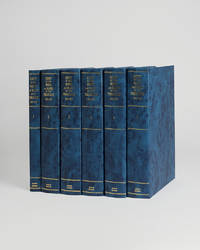
Best.-Nr. 121956London Archive editions 1990. . 5 vols 8vo; 1 vol. text with index map & 4 vols map portfolios containing 55 maps charts and views; original blue cloth gilt a fine set. The first systematic examination of the coastal topography of the Arabian Gulf. A remarkable collection of sea charts harbour plans coastal views and topographical descriptions produced during the survey of the shores and islands of the Persian Gulf carried out between 1820 and 1829 by officers of the Bombay Marine on the orders of the Bombay government. London, Archive editions, 1990. hardcover
8vo. 125, (1) pp., final blank f. With 2 double plates and several tables, diagrams and illustrations in the text. Original printed wrappers. First separate edition of this rare study in Islamic astronomy, describing a copper astrolabe made in Seville in 609 A.H. (1212/13 A.D.) by Muhammad ibn Fattouh al-Khamairy. - Occasional brownstaining, still a very good, clean copy, uncut and untrimmed. Creswell 604. OCLC 17716842.
Standard issue, 710 x 875 mm. Scale 1:36,370. Nautical chart of the Gulf of Suez from Suez southward to Ras el Ghubah on the African coast and Kad-el Towila on the Arabian coast, prepared by the British Admiralty. With small views of the light beacons on Kal ah Kebireh Shoal and Newport Rock lighthouse. - The chart shows the city of Suez, labelling hospitals, railway stations, cemeteries, the water works, and a mosque, as well as the maritime canal, Port Ibrahim and Port Thewfik. Other details include the plain of Atakah and the fresh water conduit from Atakah to Suez, the plains of Mohaggiara, and Oyun Musa, marked "the traditionary well of Moses". - The British Admiralty has produced nautical charts since 1795 under the auspices of the United Kingdom Hydrographic Office (HO). Its main task was to provide the Royal Navy with navigational products and service, but since 1821 it has also sold charts to the public. The present chart was composed after Admiralty surveys of 1870, and saw corrections following a 1927 survey carried out by the Suez Canal Company; it was first published in 1871 and saw several corrections up to 1931. - With a single fold. A few manuscript notes. With a stamp "Increase 50%" near lower right corner. Captioned in print and in a former collector's hand on verso. Small marginal tears in the centrefold; not touching image.
1994Best.-Nr. 18369Basel, Antikenmuseum, 1994. 213 S. mit zahlr. teils ganzseit. Textabb. Kl.-4°. OKart. (kl. Gebrssprn., leicht gebräunt, gering fleckig).
Best.-Nr. 28075Synergie Golf, 1986. Format 17x25 cm, reliure editeur, 197 pages.Tres bon etat.
1997Best.-Nr. Q-1572431717Triumph Books 1997. Hardcover. New. In shrink wrap. Looks like an interesting title! Triumph Books hardcover
Standard issue, 700 x 1024 mm. Scale 1:175,000 approx. Nautical chart of a small portion of the Red Sea, the Bab-el-Mandeb Strait, prepared by the British Admiralty. It shows Perim Island and Halib Island, as well as Mokka as its northernmost city. Other notable places include Ras al Ara, Ras Bab-el-Mandeb, Khor Omeira, and the Jezirat Sowabih islands. The chart pays particular attention to geological features, labelling larger and smaller hills including the Jebel Arrar or Chimney Peaks, as well as dunes and sandy plains. - The British Admiralty has produced nautical charts since 1795 under the auspices of the United Kingdom Hydrographic Office (HO). Its main task was to provide the Royal Navy with navigational products and service, but since 1821 it has also sold charts to the public. The present chart was composed after Admiralty surveys of 1891, 1900 and 1901; it was first published in 1902 and saw several corrections up to 1936. - With a single fold. A few manuscript notes. Captioned in print and in a former collector's hand on verso.
Standard issue, 710 x 1050 mm. Scale 1:144,820. Nautical chart of the southern portion of the Gulf of Suez, prepared by the British Admiralty. With two inset maps of the Hurghada anchorage and the approaches to the Hurghada south pier, as well as small views of the Ashrafi and Shadwán lighthouse, and three mountain views. - The chart details the Tor Bank, the Strait of Jubal, the Ashrafi Islands, and the Jifátin Islands. Among the most prominent places are Tor, Jebal, Ras Muhammed, and Hurghada. The inset map of Hurghada labels the Egyptian frontier force, oil and water tanks, as well as fishermen's huts. - The British Admiralty has produced nautical charts since 1795 under the auspices of the United Kingdom Hydrographic Office (HO). Its main task was to provide the Royal Navy with navigational products and service, but since 1821 it has also sold charts to the public. The present chart was composed after Admiralty surveys of 1871-72; it was first published in 1873 and saw several corrections up to 1931. - With a single fold. A few manuscript notes. With a stamp "Increase 50%" near lower right margin. Captioned in print and in a former collector's hand on verso. Some small marginal tears, hardly affecting image.
Coloured R.A.F. aeronautical chart. 738 by 573 mm. Scale 1:1,000,000. An excellent official British aeronautical chart of the Strait of Hormuz, covering part of Oman, a large section of the coastline of the United Arab Emirates (including Abu Dhabi, Dubai, Sharjah and Ras al Khaimah) and Hormuz Island. It was issued by the Geographical Section, General Staff (GSGS) as part of their 4695 series of 1:1,000,000 scale maps. The GSGS supplied maps to the British Armed Forces (in this case the R.A.F.), collected data on foreign survey networks and prepared survey data for Expeditionary Force mobilisation. - Light weakening and edge flaws to folds, but generally well preserved.