4.361 Ergebnisse
Small 4to. 2 vols. (4), VIII, 464 pp. (4), 558, (1) pp., final blank page. With 2 engraved plates and one folding map of the Mediterranean. Contemporary half calf over freen marbled boards with giltstamped spine and spine-title. Marbled endpapers. First edition of the travelogue of the French diplomat who secured the Venus de Milo for the Louvre in 1820. The Comte de Marcellus was appointed to the embassy at Constantinople in 1815, and in 1820 was sent to the ports of the Levant and the religious establishments of Palestine. His travels took him to Scio, Delos, Melos, Santorin, Cyprus, Sidon, Cairo and the pyramids, Rhodes, Athens and Smyrna. During his mission the peasant Yorgos Kentrotas discovered the Venus de Milo inside a buried niche within the ancient city ruins of Milos. The French ambassador Charles François de Riffardeau acquired the statue for France, but it was Marcellus who prevented its shipment to Constantinople and arranged for the Venus to be taken aboard a French ship instead. Chapter VIII of volume I is entirely dedicated to the Venus de Milo and its story, including an engraved illustration of the masterpiece. The other plate shows Pierre Gary, a guard of the Egyptian viceroy Muhammad Ali. - Occasional foxing. Hinges professionally restored. Provenance: contemporary library stamp of the French ethnographer Eugène de Froberville (1790-1871) to both title-pages. Later in the collection of the British historian William St Clair (1937-2021) with his pencil ownership to the front free endpaper of volume I. Weber 296. Blackmer 1087. Atabey 764. Cobham-Jeffery 36. OCLC 562749585.
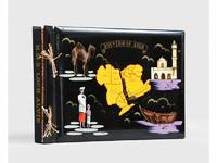
1955Best.-Nr. 188201On board HMS Loch Alvie: South Asia and Arabian Gulf 1955-56. Striking visual record of the Gulf at the dawn of the oil boom An attractive photograph album compiled by a Royal Navy rating during service in the Gulf in 1955-56 notable for its early views of Abu Dhabi and other sites in the present-day UAE on the eve of the oil transformation. Drawn to the stark coastline and improvised shore installations he recorded places that within a decade would be reshaped by petroleum infrastructure and urban expansion. Several images relate to Abu Dhabi. A view of Das Island dated 11 April 1956 shows a bare shoreline with oil drums and rudimentary structures in the first phase of development linked to the Umm Shaif field. At Khawr al Bazm 19 April 1956 he photographed the coast from the ship and the firing of a 21-gun salute for the Queen's birthday juxtaposing imperial ceremony with an undeveloped littoral. Four deckle-edged photographs depict Dalma Island - then a remote outpost - including a grave the remains of a wrecked dhow and the stretch of coast where the vessel was driven ashore in bad weather. Today Dalma is recognised as a major archaeological site within Abu Dhabi emirate. Dubai appears in a 22 April 1956 view of water taxis and the souq along Dubai Creek still a modest mercantile settlement. The following day Lord and Lady Mountbatten paused there during their return from Asia and Australasia an event marked by guards of honour and captured in the album. A coastal view of Dibba on the Musandam Peninsula - now divided between Oman and the UAE - records the rugged shoreline before modern development. Although centred on the Gulf the album also includes related regional material - Bahrain including Juffair naval base Qatar's early oil installations at Umm Said and Halul Island and shipboard scenes - placing the UAE images within the wider strategic network of Britain's post-war naval presence east of Suez. The volume concludes with an official photograph of HMS Loch Alvie and a track chart of her cruise under Captain C. J. Matthews sailing from Chatham in July 1955 and returning in July 1956. Landscape folio 270 × 390 mm. 88 mounted silver gelatine photographs the majority personal rather than purchase and 24 of which relate to the Gulf various formats mostly 105 x 80 mm the great majority captioned in white ink leaves additionally decorated with small sketches and various ephemera. Asian black lacquer album silk ties at the spine typical of those available at the Liberty Stores Aden lettered "Souvenir of Aden" on the front cover with a hand-painted map of the Arabian Peninsula and Red Sea surrounded by images of a mosque camel dhow and local inhabitants HMS Loch Alvie cap tally pasted to spine edges gilt decorative gold and silver leaf spackled endpapers; black card mounting leaves. Corners a little bumped and worn a couple of cracks to the lacquer to the back cover; some tissue guards a little creased contents otherwise clean sound and complete; very good. unknown
Best.-Nr. 606253. 4 7/8" x 9 5/8"; very good fresh; 1919. Menu folds to make a post card. Briarcliff Links Briarcliff Lodge Briarcliff Manor New York. The Golf Tournament was held July 4 1919. Ultra rare menu!. No Binding. Very Good. unknown books
1920Best.-Nr. 6622CBSamedan, Engadin Press, o. J. (um 1920). 8°. 48 S. Mit 1 gef. Karte und 1 gef. Plan. sowie 12 ganzs. Abb. nach Fotografien. Orig.-Heft mit farb. Umschlag mit Klammern-Heftung. + Wichtig: Für unsere Kunden in der EU erfolgt der Versand alle 14 Tage verzollt ab Deutschland / Postbank-Konto in Deutschland vorhanden +, Abb.
Folio (368 x 292 mm). Containing 50 albumen prints of Constantinople (ca. 270 x 21 cm each). Red half morocco album with original giltstamped cloth covers; spine blindstamped. Fine period views of the city of Constantinople, by the respected photographic studio of Sébah and Joaillier, showing landscapes as well as monuments, street scenes with merchants, etc. Pascal Sébah (1823-86), a leading Constantinople photographer, was renowned for his well-judged compositions and for the excellent print quality achieved by his technician A. Laroche. His studio, founded in 1857, was continued under his brother Cosimi and his son Jean, later in partnership with Policarpe Joaillier. The studio continued to operate as long as the year 1952. - A representative and fine example of a high-quality album aimed at the 19th century's developing Middle Eastern tourist market.
Colour printed map, 685 x 905 mm. Scale 1:7,500,000. With an inset map of "the Moslem World; percentage of Moslems in total population". Large map of Asia and the Middle East in 1952, published for the National Geographic Magazine. The map clearly shows the unresolved nature of several borders due to the waning colonial power of France and Great Britain. Notations mention that the "boundaries between India and Pakistan are not finally fixed", the borders between Saudi Arabia and Jordan are "undefined". Almost the complete Arabian Peninsula is without any border markings with only the single mention near Saudi Arabia and Trucial Oman (the future UAE) of "coastal sovereignty undefined". Showing the world before the oil boom in the Middle East, it is noteworthy that the only significant airport in Trucial Oman is that of Sharjah. - With two stamps of the University of Chicago library (including one withdrawal stamp) on the back. A few small repaired tears and some discolouring at the edges; in very good condition.
615 x 880 mm, on a scale of 1:2,000,000. Large heliozincographed folding map in black, blue and red, with relief shown by contours, hachures and gradient tints. Folded. Large detailed terrain map of the Arabian Gulf and the surrounding area with a legend of geographic denominations in English, Arabic, and Farsi, such as "Fort: Qasr (Arabic), Kaleh, Kalat (Persian)". The map shows terrain levels in particular detail and the major roads, railways and telegraph lines. The sheet latitude limits are: 24°-32° north and 44°-60° south, including Qatar, Kuwait, the Emirates, Saudi Arabia, Iran, and Iraq. - The map was published in 1912 by the India Survey Office under the direction of Sir Sidney Gerald Burrard (1860-1953), who was Colonel and Surveyor General of India in that year. He was majorly invested in the geographical and cartographic survey of India, especially the Himalayas, and retired one year after the publication of the present map. The map is based on Frederic Fraser Hunter's (1876-1959) first large scale general map of Arabia for the India Survey Office in 1906-08. Hunter was also involved as editor in the creation of the present Southern Persia map. As the Southern Persia sheet the present map is part of a very large nine-sheet combined map covering the area from the Red Sea to India, called the "Survey of India Southern Asia Series" (1912-45). The present map and a separately published index could be obtained only on application through an officer at the Map Record and Issue Office in Calcutta. - Some slight foxing, a tiny tear on the crossing of two folds, bottom edge frayed. Otherwise in good condition. D. Foliard, Conflicted Cartographies of a Peninsula. In: Geographies of Contact (2019), pp. 71-76. F. F. Hunter, Reminiscences of the Map of Arabia and the Persian Gulf, in: GJ 54 (1919), pp. 355-363.
Colour-printed map (66 x 46 cm). Not in Al Ankary; Al-Qasimi.
1147 x 850 mm. Scale 1:921,207. Engraved chart, including tidal information, compass roses, soundings, seabed notations. First published in 1898 from British Surveys to 1863. - Folded.
910 x 715 mm. Scale 1:500,000. Second edition. - In excellent condition.
1900Oblong folio. (4) pp., 8 printed illustrations in colour after photographs. Original printed wrappers. Fascicule 60 from the "Autour de Monde. Aquarelles, Souvenirs, Voyages", showing eight views from Tunisia. Depicts the cities and ports, the inhabitants, etc. - Slight edge defects, otherwise well preserved.
1920Best.-Nr. 6622CBSamedan, Engadin Press, o. J. (um 1920). 8°. 48 S. Mit 1 gef. Karte und 1 gef. Plan. sowie 12 ganzs. Abb. nach Fotografien. Orig.-Heft mit farb. Umschlag mit Klammern-Heftung.
2004Best.-Nr. 31602Paris Buchet / Chastel 2004 In-8 Traduit de l'américain par Anne-Marie Hussein - 443 pp en français - 1 ff Table - Cahier central de photographies non comprises dans la pagination. Cette édition n' est pas celle au format poche
4to. XIV, 346 pp. With end-paper maps. Blue cloth with gilt embossed titles to spine. First edition. An account of sailing with the Arabs in their dhows, in the Red Sea, around the coasts of Arabia and to Zanzibar and Tanganyika; pearling in the Arabian Gulf; and the life of the shipmasters, the mariners and merchants of Kuwait. With particular attention to Basra, Kuwait, Bahrain, and Muscat. Numerous black and white photographs by the author, the master mariner and adventurer Allan Villiers (1903-82). - A fine copy. Macro, Bibliography of the Arabian Peninsula, 2250.
Best.-Nr. M18484P, Dépôt général de la Marine 1831, grande carte gravée de 93 x 65 cm . Edition d ' Avril 1888 . Court de marge . Marge supérieure légèrement froissée . Quelques annotations de navigations .
1960267 pages. Index. Black and white photographic plates. "... Will revive controversy about one of the most appalling naval tragedies of World War II - a tragedy that had, perhaps, more far-reaching consequences than any other... Tells the story of the passing of the capital ship, as well as the story of the end of Western ascendancy over the Far East." - from dust jacket. Average wear. Unmarked. Price-clipped dust jacket now preserved in archival-grade Brodart. A sound copy. Book
4to. (43)-77 pp., final blank page. With 16 numbered plates of photographic illustrations. Original printed wrappers bound within contemporary full cloth with giltstamped spine-title, signed by R. Numans. Scarce treatise on early medieval textiles produced in the Near East, investigating the relation between Sasanian and Egyptian art. The personal copy of Carl Johan Lamm with his bookplate to front pastedown. Contains detailed descriptions and images of 62 fragments of tapestry kept at the Stockholm National Museum, the Röhss Museum in Gothenburg, and the "Kulturen" museum in Lund. - Lamm studied archaeology at the University of Stockholm. He wrote about the glass excavated at Samarra in 1928 and became a leading scholar on Islamic arts and crafts, notably in glass and carpets. He was on the staff of the Stockholm Museum and taught at Uppsala University. - In near-mint condition. Offprint from vol. XXX of "Le Monde Oriental", a journal on oriental studies published in Uppsala from 1906. OCLC 82868449.
(6), 29, (1) pp. Original printed cloth with fore-edge flap. 8vo. Only edition. "The area dealt with in this handbook is bounded on the north by the caravan route between Dair-az-Zaur and Mosul, on the east by that between Mosul and Baghdad; on the south by that between Baghdad and Fallujah; and on the west by the river Euphrates. The tract thus defined includes portions of the Baghdad and Mosul Wilayats, and of the Sanjaq of Zaur" (note on p. [iii]). - Some brownstaining to endpapers and edges, otherwise in fine condition. Rare: only two copies in libraries via OCLC (British Library; Texas A&M Univ. Library). From the library of Peter Hopkirk with his bookplate on front pastedown. Catalogue No. O.B. 44. Case No. 17217. OCLC 48133490.
4to. 193-199, (1) pp. With 7 photographic plates. Original printed wrappers bound within modern full cloth with giltstamped black spine-label. Marbled endpapers. Treatise on ancient Egyptian draw-loom weaving, picturing several textile specimens kept in London, Stockholm and Copenhagen. The personal copy of the author Carl Johan Lamm with his bookplate to front pastedown. - Lamm studied archaeology at the University of Stockholm. He wrote about the glass excavated at Samarra in 1928 and became a leading scholar on Islamic arts and crafts, notably in glass and carpets. He was on the staff of the Stockholm Museum and taught at Uppsala University. - Offprint from the archaeological journal "Bulletin de la Société d'Archéologie copte". Very well preserved. OCLC 474423945.
8vo. 233, (1) pp. Giltstamped green half calf. Top edge gilt. Only edition. First-hand account of military and intelligence operations in the Gulf area prior to and during World War I, including chapters on "The Arab Revolt in Kermak", "The Rebellion in Oman", "The Persian Gulf in 1913-14", etc. Lt.-Colonel C. C. R. Murphy, 30th Punjabis, from the Suffolk Regiment, wrote several works of military history. - Slight browning; minor chipping to top edge near beginning of volume. OCLC 13460560. Not in Macro, Bibliography of the Arabian Peninsula.
1995130 pages - Expanded 20th Anniversary Issue. Features: SOF exposes ATF's warbirds; Waco hearings - somebody's lying; Liddy's side of 'Shooting Feds' controversy; American mercs bomb Haiti; U.S. Specops pistol update; Secret SOG Ops - HALO into Laos and Cambodia; Trap team springs downed U.S. pilot; Proof - Chemical/Biological Agents used in Gulf War; D-day for X-ray - SEAL mission goes bad. Average wear. Solid unmarked copy. Book
2001Best.-Nr. LFA-126741204Une revue de 12 pages, format 220 x 285 mm, illustrée, brochée couverture couleurs, Editions Atlas, bon état
1959104 page softcover book plus three large colour maps entitled: Soil Map of Vancouver Island - Duncan/Nanaimo; Courtenay/Campbell; Qualicum/Alberni. Stored in slip case. Report No. 6 of the British Columbia Soil Survey 1959. Gift inscription upon front panel of slip case. Prior owner's name upon each component of contents. Average wear to maps and book. Taped tear along bottom edge of slip case which remains functional. Good working copy of this excellent reference. Book
62 vols. bound in 42, including: 7-16, 19, 21-25 (paper), 28-33, 37-41, 50-57, 63, 69-73, 75-77, 80, 88-92, 94-99, 102, 115, 139, 154-155, 168 (paper). Indices of 1-3, 8-11, 12-15, 28-31, 131-152, 1-39. Vol. 154 with a folded map. Mostly blue cloth with giltstamped crest and spine title, original wrappers included in the binding. 6 vols. in original wrappers. Lithogr. coloured plate of a chart at the end of vol. 56/57 added. First and only edition: a substantial torso of the League of Nations Treaty Series (LNTS), the League's officially published collection of treaties and other international engagements. Begun in 1920, it was discontinued in 1946 (following the dissolution of the League) after 205 volumes. The present set includes numerous important agreements reached during the interwar period between the western powers and those of the Middle East, such as Saudi Arabia, the Trucial States, Yemen, and Oman. - To cite but a few examples, vol. 71 includes the full Arabic and English text of the "Treaty of Friendship and good understanding between his Britannic Majesty and his Majesty the King of Hejaz and of Nejd and its dependencies. Signed at Jeddah, May 20, 1927", authorized by Faisal Abdul-Aziz al Saud, Abdul-Aziz ibn Abdul-Rahman al Saud and Gilbert Clayton, pp. 133-164, also noting: "Article 6. His Majesty the King of the Hejaz and of Nejd and its Dependencies undertakes to maintain friendly and peaceful relations with the territories of Kuwait and Bahrain, and with the Sheikhs of Qatar and the Oman Coast, who are in special treaty relations with His Britannic Majesty's Government", p. 154. - Vol. 115 includes the German and Arabic text as well as a French and English translation of the "Treaty of Friendship" between Germany and Hejaz, Neijd and dependencies of 1929 in Cairo which was authorized by Stohrer, Sheikh Hafez Wahba, and Sheikh Fausan El Sabek, pp. 266-270. - Vol. 8 includes the English text of the "Anglo-Muskat commercial treaty": "[...] the Treaty of Friendship, Commerce and Navigation between Great Britain and Oman, signed on the eighth day of Shaban 1308 H., corresponding to the 19th March, 1891, will be prolonged by this writing notwithstanding all or any correspondence between His Late Highness Syud Faisal bin Turki and the Glorious British Government [...]" authorized by Taimur bin Faisal, Sultan of Muscat and Oman and R. Wingate, I.C.S. - Vol. 25 includes the English text of the "Anglo-Muscat Treaty prolonging for one year from February 11, 1924", authorized by R. G. Hinde and Nadir, Muhammad bin Ahmad, Rashid, and Zubair in Muscat, pp. 388-391. - Vol. 168 includes the "Agreement between Great Britain and Muscat renewing for a further period of one year from February 11th, 1927, the Treaty of Friendship, Commerce and Navigation of March 19th, 1891 [...]" in Arabic, French and English authorized by Said bin Tamur, Sultan of Muscat and Oman, and Major R. P. Watts, I.A., pp. 230-233. - Vol. 96 includes the "Agreement between Great Britain and Mascat renewing for a further period of one year, from February 11, 1929, the above Treaty of March 19, 1891" in Arabic, English and French, authorized by B. S. Thomas, G. P. Murphy, and Hadji Zuber bin Ali "on behalf of his Highness Sayid Sir Taimur bin Faisal, K.C.I.E., C.S.I., Sultan of Maskat and Oman", pp. 194-197. Numerous further relevant treaties are referenced in the copious indices included with the series. - Three sets of indices bound in separate volumes, the others bound with the treaties. Some of the original wrappers somewhat damaged when not included in the binding, but well preserved. Removed from the Champlain Library of the Université de Moncton, Canada (their shelfmarks to spines and stamps to edges); previously in the library of the University of Washington, Seattle, International Fisheries Commission (their stamps to some wrappers).
1941Best.-Nr. 2092902141504340Iwanamishoten 1941. Soft Cover. Fine. The book is in fine condition. Iwanamishoten paperback