4114 risultati
rif. 201401361Paris, Les heures claires, s.d. (vers 1951) ; in-8, 26 pp., cartonnage de l'éditeur. En très bon état sous étuit ) texte en parfait état feuillet non reliés - Pointe sèches de CH. SAMSON - exemplaire n° 438-12 - pointes sèches hors texte de Charles SAMSONen feuilles sous couverture rempliée, chemise et étui.
rif. 201401360Paris, Les heures claires, s.d. (vers 1951) ; in-8, 26 pp., cartonnage de l'éditeur. En bon état sous étuit (celui-ci est bruni) texte en parfait état feuillet non reliés - Pointe sèches de CH. SAMSON - exemplaire n° 429- 12 - pointes sèches hors texte de Charles SAMSON.
rif. 22631PARIS, Ed. d'Art "Les Heures Claires" , 1958 - Grand In-4, 25,5 x 33 cms - En feuilles sous couverture illustrée et chemise (cassée), Sous Etui d' emboîtage - E.O. - Tirage limité à 500 exemplaires numérotés, L'un des 100 sur vélin de Rives contenant une suite en noir avec remarques, celui-ci N° 59 - 145 pages , 50 compositions dans le texte dont 17 à pleine page - légères rousseurs en couverture - TRES BON EXEMPLAIRE.
rif. REIS0742Wien Holzhausen 1901. Front.-Portr. IX 1611 Seiten mit zahlreichen Abbildungen nach Zeichnungen im Text 9 Tafeln mit 11 photogr. Abb. 1 Farbradierung von Fischer nach Hildebrandt. Grüner Original-Leinenband mit Einbandgoldpräg. u. Kopfgoldschnitt Lesebändchen. Frisch u. fleckenfrei sehr gut erhalten. Exlibris. Cordier Bibl. Indosinica 910. - Mit einem Vorwort von Carl Ritter von Gsiller sowie einer biographischen Skizze über den Verfasser. (Wien, Holzhausen) 1901. unknown
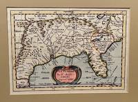
1734rif. 22619Utrecht 1734. Full-title: La Floride. Par N. Sanson d' Abbeville Geogr. Ordre du Roy. Copper engraved double-page hand colored map. Neat pencil writing on verso "Henri Du Sauzet 1734". Image size 7" x 9 7/8". Tipped in double-mat. Fold line down center else a fine copy. The map covers southern states and coastline from Secotan in Virginia to Planuco in Mexico. Showing political and administrative boundaries major cities towns villages rivers mountains drainage etc. Nicolas Sanson 1600 – 1667 was a French cartographer who served under two kings in matters of geography. He has been called the "father of French cartography." Henri Du Sauzet 1686/87 - 1754 was a bookseller/publisher in Amsterdam during the early to mid-eighteenth century. unknown
2008rif. x-1855661683Tamesis Books Ltd 2008. Hardcover. New. 384 pages. 9.50x6.50x1.00 inches. Tamesis Books Ltd hardcover
2023rif. x-946265509XT.M.C. Asser Instituut 2023. Paperback. New. 771 pages. 9.25x6.10x1.54 inches. T.M.C. Asser Instituut paperback
rif. Bloomsbury-9780313298738Praeger. Hardback. New. 288 pages Praeger hardcover
rif. 6374955like new. unknown
rif. 20034352-nnew. unknown
rif. 20034352like new. unknown
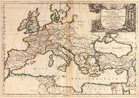
1667rif. 25060Paris: P. Mariette 1667. Other. The centre fold minor spotting else in excellent condition. 395 by 565mm 15 by 22 inches. Rare and decorative large-format historical map of Europe showing the locations of Church Councils and Synods in original outline color. By Guillaume Sanson 16331703 Géographe du Roy published by Pierre Mariette Paris 1667. Image: 395 x 565 mm 15.5 x 22 inches. Decorated with a superb allegorical title cartouche depicting a Catholic council in session a unique historical and cartographic document. Guillaume Sanson 16331703 was a leading French cartographer who inherited the celebrated family firm from his father Nicolas Sanson 16001667 known as the 'Father of French Cartography' and official Géographe du Roy to Louis XIV. Like his father Guillaume held the title of Géographe Ordinaire du Roy. Much of his work after 1671 was published in collaboration with Alexis-Hubert Jaillot and together the Sanson dynasty dominated French cartography throughout the 17th century. Their maps are held in the Bibliothèque nationale de France the British Library and major research collections worldwide.This large and striking map plots the locations of ecumenical councils national synods provincial councils and diocesan synods across Europe a unique cartographic subject of combined religious and historical significance. The coverage extends from the British Isles and Iberian Peninsula across to the eastern Mediterranean including Cyprus and Syria with North Africa also shown. Political borders are rendered in hand-applied outline color. The splendid allegorical title cartouche depicts a Catholic council in session and was engraved to the highest standard of the Parisian workshop. The Geographia Synodica is among the most unusual and collectible maps ever published of Europe: a historic document of scholarship faith and cartographic craft. In excellent condition. Original outline color fresh and vivid. The centrefold shows minor spotting as expected for a 17th-century map of this size; all else excellent. No tears or significant foxing. 395 x 565 mm. P. Mariette unknown
2019rif. DBS-9781682857274Willford 2019. 1st. Hardcover. New. Willford hardcover
1976rif. DADAX06712213961976-01-15. First Edition. hardcover. New. xx. Buy with confidence. Excellent Customer Service & Return policy. hardcover
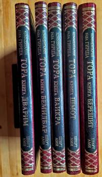
1993rif. 4876Jerusalem: Shvut Ami 1993. Hardcover Set. AsNew condition. 9.6"x6.8". be42. Contact the seller about the price of shipping. Shvut Ami hardcover
1846rif. 60753Nouvelle édition, augmentée d'une troisième partie inédite et précédée d'un avant-propos par de Pongerville, 1 vol. grand in-8 br., A. René et Cie, Paris, 1846, 320 pp. avec portrait en frontispice
2012rif. x-1780761198I B Tauris & Co Ltd 2012. Hardcover. New. 320 pages. 8.60x5.60x1.20 inches. I B Tauris & Co Ltd hardcover
1999rif. DADAX0631201890Wiley-Blackwell 1999-10-25. 1. hardcover. New. 6.90x1.30x10.00. Buy with confidence. Excellent Customer Service & Return policy. Wiley-Blackwell hardcover
1829rif. 6461615 vol. in-8 reliure demi-basane marron, dos à 5 nerfs, toutes tranches marbrées, Chez les Libraires Editeurs, Mequignon-Marvis, J.-B Baillière, Paris, 1829-1836
rif. 64508389Sage Publications . Hardback. New. pp. 284 2nd Edition Sage Publications hardcover
rif. 645597Oxford University Press OUP . Papeback. New. pp. xvii 387 Maps Oxford University Press OUP unknown
2021rif. x-0198754957Oxford Univ Pr 2021. Hardcover. New. 656 pages. 9.50x6.50x1.75 inches. Oxford Univ Pr hardcover
1654rif. 6571Paris 1654. Copper engraving 37 x 48 cms modern hand-colour blank verso. Nicolas Sanson 1600-1667 founder of the Sanson dynasty of map-makers is considered by many to be the father of the French school of cartography. He was a prolific and original map-maker admired for the clarity and scientific accuracy of his maps. Map unknown