4 065 résultats
réf. 140897aafA Amsterdam, chez P(ieter) Mortier et Compagnie: Avec Privilege, 1696-1708, Bildgröße - Karte 55 x 75 cm. (inkl. Wappen u. d. Titel über dem Rand 57x83 cm.), Carte géographique coloriée, français (1696-1708), publiée dans : Atlas Nouveau, Contenant toutes les Parties du Monde, ou sont exactement remarqués les Empires, Monarchies, Royaumes, Estats, Républiques & Peuples, entre 1696-1708. Unter Glas im Goldrahmen (92 x 66 cm).
réf. 7083Paris, Flammarion, 1933 12 x 19, 225 pp., broché, non coupé, bon état
réf. 70801Paris, Ernest Flammarion, 1933. 12 x 19, 225 pp., broché, non coupé, bon état.
1897réf. 71341897 Paris, Librairie agricole de la maison rustique, 1897, in 8 br. de VI-163-4 pp. de catalogue, couverture illustrée, bon ex.
réf. c2706Paris, Librairie agricole de la Maison Rustique,1897 ;in-8°,broché,couverture beige imprimée et illustrée en noir; VIpp.,163pp.,4pp.(catalogue); petite tache d'encre noir à la couverture en pied au 1er plat et dos et au 2ème plat,avec petites traces dans la marge supérieure et inférieure des 4 derniers feuillets, mais exemplaire fort correct.
réf. 15082P., Desclée de Brouwer, 1941, in 12 broché, 54 pages.
réf. 30176P., Desclée de Brouwer, 1941, in 12 broché, 54 pages ; couverture fanée avec petite déchirure sans manque ; inscriptions manuscrites sur le faux-titre.
réf. 41969P., Flammarion, 1933, in 12 broché, 225 pages.
réf. 215194Paris, Desclée, De Brouwer, s.d. (1941) in-12, 54 pp., broché.
réf. ce1572A compte d'auteur Dos agrafé In-8 (15 x 21 cm.), fascicule au dos agrafé, couverture illustrée, 35 pages, charmantes illustrations in-texte de Kassape Sanson, sans date ; comme neuf. Livraison a domicile (La Poste) ou en Mondial Relay sur simple demande.
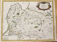
1700réf. M7994Paris c. 1700. Very Good. Notes: Engraved by Cordier. A map of Central Germany. Frankfurt appears at the south-center of the map. Size : 457x648 mm 17.99x25.51 Inches Coloring: Original Hand Coloring Category: Maps Europe Germany; unknown
réf. 0259218197.Gpaperback. Good. Access codes and supplements are not guaranteed with used items. May be an ex-library book. paperback
réf. 0265479150.Ghardcover. Good. Access codes and supplements are not guaranteed with used items. May be an ex-library book. hardcover
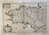
1693réf. 324404Paris: Alexis-Hubert Jaillot 1693. Map. Engraving with hand colored outline. Image measures 21" x 31" This large 17th century double-page map features the Brittany region of France. Cities towns abbeys government buildings rivers ports and harbors are labeled. Mountains forests and wetlands are depicted pictorially. The attention to detail in topography and population centers hints at the abundance of the region known for its production of Muscadet wine cheese boar seafood and other agricultural products. Executed by Nicolas Sanson in dedication to his son this map was published by Alexis-Hubert Jaillot in Paris and later reproduced in Amsterdam by Jaillot and Pierre Mortier. This early edition is scarce and hard to find. In very good condition with some offsetting to left side and a spot in the right margin. Nicolas Sanson 1600-1667 is considered the founder of the French school of cartography. In reaction to the prevailing trend of Dutch lavishness Sanson favored minimal details focusing rather on accurate cartography than ornament. Alexis-Hubert Jaillot unknown
1693réf. 324404Paris: Alexis-Hubert Jaillot 1693. Map. Engraving with hand colored outline. Image measures 21" x 31" This large 17th century double-page map features the Brittany region of France. Cities towns abbeys government buildings rivers ports and harbors are labeled. Mountains forests and wetlands are depicted pictorially. The attention to detail in topography and population centers hints at the abundance of the region known for its production of Muscadet wine cheese boar seafood and other agricultural products. Executed by Nicolas Sanson in dedication to his son this map was published by Alexis-Hubert Jaillot in Paris and later reproduced in Amsterdam by Jaillot and Pierre Mortier. This early edition is scarce and hard to find. In very good condition with some offsetting to left side and a spot in the right margin. Nicolas Sanson 1600-1667 is considered the founder of the French school of cartography. In reaction to the prevailing trend of Dutch lavishness Sanson favored minimal details focusing rather on accurate cartography than ornament. Alexis-Hubert Jaillot unknown books
1659réf. M4916Paris 1659. Very Good. Notes: Map of Baltic region of Estonia Latvia including Riga to Vilnius Wilna and parts of Lithuania. Nicolas Sanson 1600–1667 was a renowned French cartographer termed by some as the "father of French cartography." His works are known for their incorporation of the most up to date information of the time and their clean modern style. Size : 410x535 mm 16.125x21 Inches Coloring: Original Outline Coloring Reference: Category: Maps Europe Estonia Latvia unknown
réf. 0364632410.Ghardcover. Good. Access codes and supplements are not guaranteed with used items. May be an ex-library book. hardcover
réf. 0666488207.Gpaperback. Good. Access codes and supplements are not guaranteed with used items. May be an ex-library book. paperback
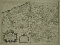
réf. 30600Paris: Jaillot. 1689. 43.1 x 57 cm. Original outline colour. Single page folio map of southern Flanders and Artois. Blank on verso. Small tear without loss at upper edge just touching image. Small section of upper margin missing though not affecting map. Small brown spot to centre of lower edge. Paris: Jaillot. 1689 unknown
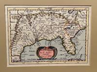
1734réf. 22619Utrecht 1734. Full-title: La Floride. Par N. Sanson d' Abbeville Geogr. Ordre du Roy. Copper engraved double-page hand colored map. Neat pencil writing on verso "Henri Du Sauzet 1734". Image size 7" x 9 7/8". Tipped in double-mat. Fold line down center else a fine copy. The map covers southern states and coastline from Secotan in Virginia to Planuco in Mexico. Showing political and administrative boundaries major cities towns villages rivers mountains drainage etc. Nicolas Sanson 1600 – 1667 was a French cartographer who served under two kings in matters of geography. He has been called the "father of French cartography." Henri Du Sauzet 1686/87 - 1754 was a bookseller/publisher in Amsterdam during the early to mid-eighteenth century. unknown
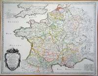
réf. 6420Paris: 1693. No binding. Good. 440 x 570 mm. early outline colour in good condition. A particularly attractive map of France or ancient Gaul. It famously depicts the country before Louis XIV lost a third of his territory to mapmakers who concluded that the longitudinal width of the country was not as great as was depicted! Not in Pastoureau 1984. 1693 unknown
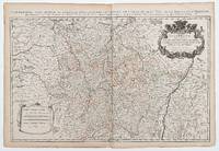
réf. 49665Paris: 1690. 54 x 87.5 cm. Double page copper engraved map of Lorraine. Original outline colour. Large decorative cartouche to upper right corner. Horizontal crease parallel and adjacent to centrefold otherwise good. [Paris:] 1690 unknown
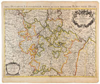
1710réf. 009140Amsterdam: Pierre Mortier 1710 Cooper engraving 46.5 x 61.5 cm on paper measuring 54.0 x 64.5 cm with original color in outline minor spotting and creasing remnants of centerfold. A good copy of a map of the Duchy of Lorraine and surrounding territories published in Amsterdam by Pierre Mortier to illustrate events of the War of the Spanish Succession. Pierre Mortier unknown
réf. 0364430451.Ghardcover. Good. Access codes and supplements are not guaranteed with used items. May be an ex-library book. hardcover
1897réf. 38358Paris: Lib. agricole de la Maison rustique 1897. Fine. Lib. agricole de la Maison rustique Paris 1897 11.50 x 18.50 cm relié Third edition. Full black cloth binding smooth spine minor epidermis damage to boards two small lacks to one joint an ink stain affecting the margins but not the text. Work illustrated with 34 figures in the text. Lib. agricole de la Maison rustique hardcover