Samson, GaryBiblio.com

4034 risultati
rif. 1531602959.Ghardcover. Good. Access codes and supplements are not guaranteed with used items. May be an ex-library book. hardcover
2000rif. Q-0738504777Arcadia Publishing 2000-10-30. Paperback. New. In shrink wrap. Looks like an interesting title! Arcadia Publishing paperback
2000rif. DADAX0738504777Arcadia Publishing 2000-10-30. paperback. New. 6.50x0.31x9.25. Buy with confidence. Excellent Customer Service & Return policy. Arcadia Publishing paperback
rif. ORD-9673Flammarion. s.d. In-8 br. 337pp. Ouvrage dédié à Camille Flammarion.
2004rif. 050989Baltimore: Publish America 2004. Book. Very Good. Paperback. 1st Printing. Scarce! Includes author's business card tucked inside. 238pp. Publish America Paperback
2004rif. G141371661XI2N00PublishAmerica Incorporated 2004. Paperback. As New. Disclaimer:An apparently unread copy in perfect condition. Dust cover is intact; pages are clean and are not marred by notes or folds of any kind. At ThriftBooks our motto is: Read More Spend Less.Dust jacket quality is not guaranteed. PublishAmerica, Incorporated paperback
rif. 1666759198.Ghardcover. Good. Access codes and supplements are not guaranteed with used items. May be an ex-library book. hardcover
rif. 2841972054.Gpaperback. Good. Access codes and supplements are not guaranteed with used items. May be an ex-library book. paperback
rif. RO30068101LIBRAIRIE DE L'INCONNU. non daté. In-8. Broché. Bon état, Couv. convenable, Dos satisfaisant, Intérieur frais. 128 pages. Quelques dessins en noir et blanc dans le texte.. . . . Classification Dewey : 133.3-Procédés divinatoires, cartomancie
rif. R100070615Librairie de l'inconnu. non daté. In-8. Broché. Bon état, Couv. convenable, Dos satisfaisant, Papier jauni. 128 pages - quelques illustrations en noir et blanc dans le texte.. . . . Classification Dewey : 133.3-Procédés divinatoires, cartomancie
rif. 11664S.l.n.d., Librairie de l'inconnu, In-8°, 128 pp., ill. dans le texte. Broché (couv. passée et lég. défr., cachet ex-libris du lion d'émeraude sur la garde sup., bon état intérieur).
rif. 11664S.l.n.d., Librairie de l'inconnu, In-8°, 128 pp., ill. dans le texte. Broché (couv. passée et lég. défr., cachet ex-libris du lion d'émeraude sur la garde sup., bon état intérieur).
1970rif. R300009676BAILLIERE. 1970. In-8. Broché. Bon état, Couv. convenable, Dos satisfaisant, Intérieur frais. 169 pages - quelques figures en noir et blanc dans et hors texte.. . . . Classification Dewey : 635.99-Culture des plantes en pot
rif. 22192Editions Ernest Flammarion, sans date. In-12 broché de 337 pages au format 12 x 19 cm. Belle couverture typographique sur papier couleur bordeaux. Titre argenté. Dos carré, avec infime manque au bas. Plats et intérieur frais. L'Auteur a collé une feuille tapuscrite avec la liste de ses ouvrages parus et à paraitre. Livre qui narre de façon romancé la décadence et la chute du Roi de Babylone, Balthazar. Ouvrage dédié à Camille Flammarion. Trois pages in-finé avec différentes critiques sur le livre. Exemplaire enrichi d'une belle dédicace non nominative, autographe, signée et datée ( 1923 ) de l'auteur.
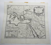
1707rif. 23156Amsterdam: Pierre Mortier. Very Good with No dust jacket as issued. c.1707. Map. 3 pieces of brown paper tape along upper blank margin.; No date c. 1707. We think this map is possibly from "Le Sainte Bible" edited by David Martin Amsterdam 1707. Dimensions of sheet: 508 x 451mm. Dimensions of printed area: 439 x 368mm. Uncoloured. Copperplate engraved map. Elaborate cartouche. Centrefold. With inset map at lower left "Campemens des Israelites dans le Desert". "The first Pieter Mortier was an 18th-century mapmaker and engraver who was born in Leiden the son of a political refugee from France. He travelled to Paris in 1681-1685 then returned to Amsterdam where he operated as a bookseller from 1685 until 1711. He won the privilege in 1690 of publishing maps and atlases by French publishers in Amsterdam for the Dutch market. He used this privilege to win a similar set of privileges for printing an "illustrated print bible" in 1700." - Wikipedia entry on Pieter or Pierre Mortier accessed October 2021. NB: This map will be posted rolled in a mailing tube. . Pierre Mortier unknown
1650rif. 24869London 1650. 1 vols. 13" x 8 3/4. Contemporary. hand-coloring. Fine condition. 1 vols. 13" x 8 3/4 ". unknown
1650rif. 24869London 1650. 1 vols. 13" x 8 3/4. Contemporary. hand-coloring. Fine condition. 1 vols. 13" x 8 3/4 ". unknown books
rif. 2092902138101576Not Available N.A. Soft Cover. Fine. Size: Plate: 18.5cmx24cm / Paper: 39cmx48cm Number of copies: 1 sheet Not Available paperback
rif. 71-2849Paris: Nicholas Sanson 1656. Hand colored engraving. 18.5 x 29.7 cm. plate. Very Good folded in center. Paris: Nicholas Sanson, 1656. unknown
rif. a8664Le Cercle de Westphalie. 25x38 inches. A double panel map profesionally joined together at seam. Colored in outline. Highly detailed. VG. . unknown
rif. 61441Paris Alexis Hubert Jaillot 1700. One sheet ink on paper. Copper engraving. Hand painted. Good condition. The map depicts the upper and lower Rhine region from Metz in the north to Lake Como in the south and Dijon in the west to Augsburg in the east. On the left hand side is the legend with miles to Italian French and German miles. In passepartout total size 650 x 750 mm. unknown
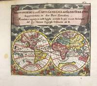
1697rif. M11198Antwerp Belgium: Jan Duren c.1697. Very Good. Notes: Rare miniature World map. California is depicted as an island. There are symbols for the four continents: dangerous America strong Europe exotic Asia and wild Africa. Size : 140x160 mm 5.51x6.30 Inches Coloring: Hand Colored Reference: Shirley #553. Category: Maps World; Jan Duren unknown
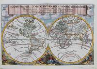
1692rif. M9110Trajecti ad Rhenum : Francisci Halma c. 1692. Very Good. Notes: A finely engraved map of the world by Nicolas Sanson "the father of French cartography" during the late 17th century. Engraved by A. de Winter. There are a lot of fascinating cartographic errors that were made such as California being shown as an island and the western half of North America not being depicted as it had yet to be discovered. But the treatment of far and southeast Asia is much improved when we compare it to Sanson's map of 1652. Korea reverts to an attenuated peninsula instead of the short squat round island in the earlier Sanson version. Likewise the partial outline of Australia changes it shape to a much more realistic outline of Australia. Size : 200x305 mm 7.87x12.01 Inches Coloring: Hand Colored Category: Maps World; Francisci Halma unknown