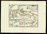
SANSON d'ABBEVILLE (Nicolas).Livre Rare Book
Sanson Véronique - Swell Bernard - Swell BernardLivre Rare Book
Partition de la chanson : Amour qui m'irait bien (Un)
1997réf. 110992Piano Blanc 1997

Le Temps des Chansons · Paris, France8,00 €
4 093 résultats
1652réf. LBW041961652. 188 x 251 mm.
1997réf. 110992Piano Blanc 1997
1985réf. 110993Piano Blanc 1985
1997réf. 110996Piano Blanc 1997
1988réf. 110997Piano Blanc 1988
1997réf. 110998Piano Blanc 1997
1985réf. 110999Piano Blanc 1985
1972réf. 111000Piano Blanc 1972
1985réf. 111002Piano Blanc 1985
1997réf. 111003Piano Blanc 1997
1988réf. 111005Piano Blanc 1988
1979réf. 111006Piano Blanc 1979
1988réf. 111008Piano Blanc 1988
1979réf. 111009Piano Blanc 1979
1981réf. 111010Piano Blanc 1981
1988réf. 111011Piano Blanc 1988
1988réf. 111013Piano Blanc 1988
1985réf. 111014Piano Blanc 1985
1988réf. 111015Piano Blanc 1988
1979réf. 111016Piano Blanc 1979
1976réf. 111017Piano Blanc 1976
1997réf. 111018Piano Blanc 1997
1992réf. 111020Piano Blanc 1992
1652réf. 17601Paris: chez l'autheur 1652. 265 by 370mm. 10.5 by 14.5 inches. Maps""Les Isles Molucques; Celebes Gilolo &c. Sanson's Moluccas Engraved chart with contemporary hand-colour in outline. Detailed map of the island east of Borneo in Southeast Asia with an inset of Banda and the Moluccas. Published in Sanson's 'L'Asie en Plusieurs Cartes.' 1652. Nicolas Sanson 1600-1667 began to make maps to supplement his study of history and a map of Ancient Gaul made early in his career brought him to the attention of Cardinal Richelieu. This foothold in the French court allowed him to rise to the position of geographe du roi teaching both Louis XIII and Louis XIV. Louis XIII even made him a counsellor of state. Sanson produced an atlas 'Cartes Generales de Toutes les Parties du Monde' which contained important maps of the post roads and waterways of France. He also produced two major maps of North America: 'Amerique Septentrionale' 1650 was the first map to show the Great Lakes in a recognisable form aided by Sanson's access to The Jesuit Relations a collection of accounts by French missionaries to the area. The map was drawn on a sinusoidal projection which Sanson was the first to use. In 1656 he made 'Le Canada ou Nouvelle France' which showed the Great Lakes in greater detail and included accurate representations of the Hudson Bay area the Delaware and the Gulf of Saint Lawrence. chez l'autheur, unknown
18192 vols., 12mo., with fine engraved and printed titles, and a total of 8 engraved plates after Westall (most original tissue guards present), some minimal offsetting from plates; ORIGINAL BOARDS, very neatly rebacked to style, ORIGINAL PRINTED PAPER LABELS PRESERVED (labels chipped and worn but virtually all lettering entirely legible), uncut, boards mildly age-stained with a few old tape marks, else a most attractive and remarkably clean, crisp set in tastefully restored publisher's binding. The engraved titles, all after Westall and dated 1816, are by Engleheart (Vol. I: Paradise Regained) and Rhodes (Vol. II: Minor Poems). The fine engraved and captioned plates are also after Westall and dated 1816. In the first volume, the plates stand before Paradise Lost (Finden), Samson Agonistes (Romney) and Comus (Heath); in the second, the plates stand before Lycidas (Engleheart), L'Allegro (Heath), Il Penseroso (Mitan), Sonnets (Heath) and Odes (Finden).In the first volume Paradise Regained is paginated by line number only; the other works (including Arcades) are all separately paginated. In the second volume the pagination is continuous (including the Index).Something of a bibliographical puzzle here. The two volumes were clearly published as a set (vide the publisher's labels) but we can find no clear record of them as such. Volume I appears to be unrecorded by Stevens, falling as it does between Sharpe's first edition of 1809 and his quite distinct two-volume edition of 1827. Volume II would appear to be a later issue of Stevens 264 (who records the first edition thus as 1817 despite the dating on the engraved title). He makes the point that Vol. II was 'bound with his Paradise Regained, 1817' but lists no printings in 1819. These complexities notwithstanding, a scarce and delightful pair in well-nigh original period binding.