Samson, ColinBiblio.com

4.085 Ergebnisse
1999Best.-Nr. DADAX0631201890Wiley-Blackwell 1999-10-25. 1. hardcover. New. 6.90x1.30x10.00. Buy with confidence. Excellent Customer Service & Return policy. Wiley-Blackwell hardcover
1999Best.-Nr. DADAX0631201904Wiley-Blackwell 1999-10-25. 1. paperback. New. 7.87x0.59x9.84. Buy with confidence. Excellent Customer Service & Return policy. Wiley-Blackwell paperback
1997Best.-Nr. x-027595577XPraeger Pub Text 1997. Hardcover. New. 307 pages. 9.75x6.75x1.50 inches. Praeger Pub Text hardcover
Best.-Nr. CD11863Nts Records CD dans un parfait état Samson Head On Label: Air Raid Records AIRCD9 Format: CD, Album Pays: UK Sortie: 2000 Genre: Rock Style: Heavy Metal
Best.-Nr. 3030933792.Gpaperback. Good. Access codes and supplements are not guaranteed with used items. May be an ex-library book. paperback
Best.-Nr. ria9783030933791_inpPaperback. New. New Book; Fast Shipping from UK; Not signed; Not First Edition; This book deals with existing technologies of solar energy conversion as well as novel methods under consideration in academic and commercial R&D sites. The experimental results presented in the work are well crafted by both analy paperback
Best.-Nr. B9783030933791Paperback / softback. New. This book deals with existing technologies of solar energy conversion as well as novel methods under consideration in academic and commercial R&D sites. paperback
2001Best.-Nr. x-0198537816Oxford Univ Pr on Demand 2001. Hardcover. New. 556 pages. 9.50x5.75x1.25 inches. Oxford Univ Pr on Demand hardcover
Best.-Nr. 6503071Clarendon Press . Hardback. New. pp. 668 Clarendon Press hardcover
Best.-Nr. 62277726Clarendon Press . Hardback. New. pp. 556 Clarendon Press hardcover
2021Best.-Nr. PEN-CA1-28-07-26-005Springer 2021-10-01. hardcover. Very Good. 8x2x9. Minor wear on edges and corners. Clean pages with no markings. You will receive the exact copy shown in the photos.Ships same day in most cases!Any queries just ask for photos. Your satisfaction matters! Springer hardcover
1961Best.-Nr. 29169L.T. Slaughter & Company 1961. SAMSON P. HAH-FI! Cedar Falls Iowa: L.T. Slaughter & Company 1961. 16mo. printed wraps. Limited Edition of 1000 numbered copies. Volume One. Near fine. $15.00. L.T. Slaughter & Company unknown books
Best.-Nr. 62660Librairie Rambaud, Romans sd ( 1946 ), in-8 cartonnage éditeur illustré, dos toilé, 104pp avec des photographies in-texte et une grande carte dépliante en couleurs - très bon état
Best.-Nr. 1917503725.Gpaperback. Good. Access codes and supplements are not guaranteed with used items. May be an ex-library book. paperback
2026Best.-Nr. x-1917503725Lived Places 2026. Paperback. New. 238 pages. 6.00x0.50x9.00 inches. Lived Places paperback
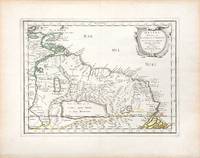
Best.-Nr. 3247Americas: Amsterdam Francois Halma 1705. Copper engraved map of Guyana by N. Sanson from Halma's Algemeene Werelde Beschryving Vol. 3 Black and white; title in Dutch; verso blank; strapwork title cartouche. The map shows a large lake or inland sea Lac ou Mer que les Caribes appellent Parime les Iaoyi Roponowini. and located on its shores the mythical city of El Dorado or Manoa. Lake Parime or Lake Parima is a legendary lake located in South America. It was reputedly the location of the fabled city of El Dorado also known as Manoa much sought-after by European explorers. Repeated attempts to find the lake failed to confirm its existence and it was dismissed as a myth along with the city. The search for Lake Parime led explorers to map the rivers and other features of southern Venezuela northern Brazil and southwestern Guyana before the lake's existence was definitively disproved in the early 19th century. Some explorers proposed that the seasonal flooding of the Rupununi savannah may have been misidentified as a lake. Recent geological investigations suggest that a lake may have existed in northern Brazil but that it dried up some time in the 18th century. Both "Manoa" Arawak language and "Parime" Carib language are believed to mean "big lake". This map appeared in Algemeene Weereld-Beschryving nae de Rechte Verdeeling der Landschappen Plaetsen Zeeën Rivieren &c. Geographisch Politisch Historisch Chronologisch en Genealogisch a Dutch edition of A. Phérotée de la Croix's Nouvelle Methode Pour Apprendre Facilement la Geographie Universelle which first appeared in 1690. Dark impression. Nicolas Sanson d'Abbeville.1600-67 ' father of the French cartography' and founder of the Sanson firm. Atlas ' Cartes générales de toutes les parties du Monde' 1658-70 and a pocket atlas in 4 parts 1652-1705. Sanson's small maps from A. Phérotée de la Croix's Nouvelle Methode Pour Apprendre Facilement la Geographie Universelle. first published in 1652 and engraved by A. Peyrounin were copied several times by various map publishers. Johann David Zunners made copies of Sanson's maps for his German translation of Die Gantze Erd-Kugel in 1679. Johannes Ribbius and Simon de Vries published copies in 1682 and 1683 with new maps engraved by Antoine d'Winter. The plates were later sold to Francois Halma who used them in 1699 and then again in 1705 with the titles re-engraved in Dutch. François Halma 1653 - 1722 Dutch publisher/printer; dealer/auction house. Cartographer and publisher of maps active in Utrecht Amsterdam Franeker and Leeuwarden. Published 'Description de l'Univers' 1700; 'Algemene Wereldtbescrijving' 1705; 'Corpus Inscriptionum' 1707 and 'Lexicon Philosophicum' 1713. Keoman: Hal 1; Phillips 528. Americas South America Guyana Guiana Amsterdam Francois Halma 1705 unknown
1700Best.-Nr. 54043Nicolas Bion: L'Usage des Globes. Amsterdam: Francois Halma. 1700. Map showing north-east South America from Trindad to the mouth of the Amazon - modern day Guyana and Surinam. Several large fictitious lakes make up much of the unexplored interior. Maps by Sanson in original colour are rare. Nicolas Sanson was founder of the French school of mapmakers at a time when the leadership in European cartography passed from the Low Countries to France. This map was published in Bion's treatise on globes. Nicolas Bion was a famous French mathematical and scientific instrument maker. Copper engraving. Very good condition. Small 1cm. very faint library stamp on border not affecting map. Original colour. Size: 27.5 x 20 cm. 11 x 8 inches. unknown
1657Best.-Nr. 66689Paris. c. 1657. A very attractive and finely engraved map of the north eastern South American country of Guiana. The map is highlighted by numerous rivers tributaries mountains villages inlets bays and a very large inland equatorial lake that was thought to exist. Published in "Cartes Generales de toutes les parties du monde." Size: 285 x 360 mm. Copperplate engraving with original outline colouring. Fine condition. unknown
Best.-Nr. 12583broché - 15x22 - 163pp - 1996 -
1997Best.-Nr. R200036616EDITIONS TRAJECTOIRE. 1997. In-4. Broché. Bon état, Couv. convenable, Dos satisfaisant, Intérieur frais. 333 pages.. . . . Classification Dewey : 619-Médecine expérimentale
1993Best.-Nr. RO20208295JACQUES GRANCHER. 1993. In-12. Broché. Bon état, Couv. convenable, Dos satisfaisant, Intérieur frais. 209 pages. . . . Classification Dewey : 360-Problèmes et services sociaux. Associations
2004Best.-Nr. RO20252912TELEMAQUE. 2004. In-8. Broché. Etat d'usage, Couv. convenable, Dos satisfaisant, Intérieur frais. 127 pages.Nombreuses illustrations en couleurs hors texte. . . . Classification Dewey : 629.2-Automobile
1993Best.-Nr. R200140504Jacques Grancher. 1993. In-12. Broché. Etat d'usage, Coins frottés, Dos plié, Intérieur frais. 209 pages - ex-dono à l'encre en page de faux-titre, passages de texte soulignés au crayon papier sur quelques pages.. . . . Classification Dewey : 53-Guide
1999Best.-Nr. 100070064Librairie De L' Inconnu 1999 162 pages 15x22x1cm. 1999. Broché. 162 pages.
Best.-Nr. 3244Americas: Amsterdam Francois Halma 1705. Copper engraved map of Guatemala by N. Sanson from Halma's Algemeene Werelde Beschryving Vol. 3 Black and white; title in Dutch; verso blank; strapwork title cartouche. This map appeared in Algemeene Weereld-Beschryving nae de Rechte Verdeeling der Landschappen Plaetsen Zeeën Rivieren &c. Geographisch Politisch Historisch Chronologisch en Genealogisch a Dutch edition of A. Phérotée de la Croix's Nouvelle Methode Pour Apprendre Facilement la Geographie Universelle which first appeared in 1690. Dark impression. Nicolas Sanson d'Abbeville.1600-67 ' father of the French cartography' and founder of the Sanson firm. Atlas ' Cartes générales de toutes les parties du Monde' 1658-70 and a pocket atlas in 4 parts 1652-1705. Sanson's small maps from A. Phérotée de la Croix's Nouvelle Methode Pour Apprendre Facilement la Geographie Universelle. first published in 1652 and engraved by A. Peyrounin were copied several times by various map publishers. Johann David Zunners made copies of Sanson's maps for his German translation of Die Gantze Erd-Kugel in 1679. Johannes Ribbius and Simon de Vries published copies in 1682 and 1683 with new maps engraved by Antoine d'Winter. The plates were later sold to Francois Halma who used them in 1699 and then again in 1705 with the titles re-engraved in Dutch. François Halma 1653 - 1722 Dutch publisher/printer; dealer/auction house. Cartographer and publisher of maps active in Utrecht Amsterdam Franeker and Leeuwarden. Published 'Description de l'Univers' 1700; 'Algemene Wereldtbescrijving' 1705; 'Corpus Inscriptionum' 1707 and 'Lexicon Philosophicum' 1713. Keoman: Hal 1; Phillips 528; B Americas Central America Guatemala Amsterdam Francois Halma 1705 unknown