Dawson, Llewellyn StylesMareMagnum

227 risultati
1969Approximately 340 pages in total. Originally printed in 1885. "Until recently the only comprehensive work on the Admiralty Hydrographic Department this book still remains one of the most important books on the history of hydrography... Particularly useful in providing information about the lesser-known hydrographers of the nineteenth century... Also includes a description of the United States coast survey. Contains a new Preface and a list of more than 80 corrections and additions compiled by researchers at the Admiralty." - from dust jacket. Usual library markings. Binding sound. Worthy reference copy. Book
17742 volumi in-12° (mm 156x81), pp. XI, (1), 327, (1); XXII, (2), 348. Legatura coeva in pergamena , titoli in oro su tassello ai dorsi, tagli spruzzati in rosso. La celebre opera di Gregorio Leti, apparsa per la prima volta a Roma nel 1674, non benevola illustrazione della corte pontificia in cui l'autore si cela sotto lo pseudonimo del Cavalier Lunadoro. Più volte riproposta anche nel secolo successivo, l'edizione che presentiamo è accresciuta da Francesco Antonio Zaccaria, e nella Parte seconda è inserito un capitolo dedicato alle funzioni e all'organizzazione del Tribunale dell'Agricoltura, "una speciale soprantendenza alle cause appartenenti ad animali, a pascoli, campagne, ed altre cose di simil fatta; ed a Persone impiegate in Campestri lavori" (pp. 326-327). Minime bruniture ma buon esemplare. A entrambi i frontespizi nota di possesso datata 1776 ‘Giambattista Motella' e timbro di antica collezione in inchiostro. . .
1674In-4°,(20), 360, (60), 328pp, 3 carte di tavola ripiegate, antiporta, illustrazioni; buone condizioni, legatura in pergamena piena, tassello al dorso. Buona edizione di questa raccolta, curata da Goes, di autori latini sul tema dell'agronomia e dell'agrimensura. In parte già edita nel 1554 da André Turnèbe, fu successivamente Nicolas Rigault (Paris, 1577-1654, erudito letterario e latinista, succeduto a Casaubon nella carica di bibliotecario regio) che ne promosse una nuova edizione a Parigi nel 1614 sotto il titolo Auctores finium regundorum... Entrambe le edizioni risultarono offuscate da codesta del 1674. Il trattato comprende opere di scrittori latini quali: Siculus Flaccus, De conditionibus agrorum; Julius Frontinus, De coloniis libellus e De agrorum qualitate; Hyginus, De limitibus constituendis; Innocentius, De litteris et notis juris exponendis. Le numerose incisioni in rame e legno nel testo rappresentano schematicamente paesaggi rurali con fiumi, monti, case, castelli, boschi, fonti e i simboli usati nelle piante dei catasti agrari romani e nella determinazione dei fondi rurali. Brunet, IV/1195. Bibl. Agronomique, n. 1718: "Ouvrage estimé et recherché; assez rare". In-4 °, (20), 360, (60), 328pp, 3 folded tables, frontispiece, plates; good condition, vellum binding, label at the spine. Good edition of this collection, edited by Goes, of Latin authors on the subject of agronomy and land surveying. Partly already published in 1554 by André Turnèbe, it was subsequently Nicolas Rigault (Paris, 1577-1654, literary scholar and latinist, who succeeded Casaubon in the position of royal librarian) who promoted a new edition in Paris in 1614 under the title Auctores finium regundorum ... Both editions were blurred by this 1674. The treatise includes works by Latin writers such as: Siculus Flaccus, De conditionibus agrorum; Julius Frontinus, De coloniis libellus and De agrorum qualitate; Hyginus, De limitibus constituendis; Innocentius, De litteris et notis juris exponendis. The numerous engravings in the text schematically represent rural landscapes with rivers, mountains, houses, castles, woods, sources and symbols used in the plants of the Roman land registers and in the determination of rural funds. Brunet, IV / 1195. Bibl. Agronomique, n. 1718: "Ouvrage estimé et recherché; assiz rare".
1589rif. 7573CBVenedig, Per Francesco Franceschi, 1589. Kl.-4°. 143 (von 145) Bl., (3) Bl. Mit 2 gef. Tafeln and more than 145 Holzschnitte im Text. Pappband der Zeit, mit Kleisterpapierbezug. + Wichtig: Für unsere Kunden in der EU erfolgt der Versand alle 14 Tage verzollt ab Deutschland / Postbank-Konto in Deutschland vorhanden +
1682Dedicato all'Illustrissimo Francesco Ferroni. Seconda edizione definitiva più completa della prima del 1603. Molto rara e importante per la vastità di argomenti e notizie. Vedi Riccardi I 478 : " Opera interessantissima per la storia dell' aritmetica, ampiamente sviluppata ed applicata anche alla mercatanzia; e per quella della geometria pratica, trovandovisi la descrizione e l'uso degli strumenti allora conosciuti, fra i quali sono notevoli quelli che ora direbbersi celerimensura. In 4to, mm. 1675x235, 1 carta bianca, con ex libris e nota manoscritta di vecchio proprietario + 12 carte non numerate + 551 pagine + 1 carta bianca finale. Molte illustrazioni xilografiche nel testo. Marca tipografica incisa al verso dell'ultima pagina di testo: Lupa che allatta i gemelli, nota manoscritta coeva di possesso, sull'occhietto. Esemplare in barbe, l'opera si occupa di aritmetica, calcolo degli interessi dei cambi, rivelazione delle misure. Legatura coeva in cartone grezzo editoriale, titolo manoscritto, restauro ben eseguito al piede del dorso, rimarginatura della parte bianca alle ultime due carte. Codice inv.3024527
1770rif. 59178France Paris Undated around 1770. Folio. 425 x 28 cm. Loose sewn 4 by 4 leaves in portfolio with ties. Title-page and 9 pp. written in a fine large legible hand but unidentified in brown ink. Having 5 No 1-5 manuscript maps and plans in double folio with some hand-colouring. On good thick paper clean and fine. unknown
1770rif. 59178France (Paris ?), Undated, around 1770. Folio. (42,5 x 28 cm.). Loose, sewn 4 by 4 leaves in portfolio with ties. Title-page and 9 pp. written in a fine, large legible hand, but unidentified, in brown ink. Having 5 (No 1-5) manuscript maps and plans in double folio with some hand-colouring. On good thick paper, clean and fine.
1800in-4, pp. (8), 423, leg. cart. rust. coevo. Con una tav. xilogr. rip. raff. diagrammi. Seconda ediz. (sulla prima del 1763), opera del milanese G. (1733-1778) molto ben illustrata da schemi, diagrammi e scene campestri. Dalla prefazione: “L’Euclide in Campagna divenne quindi in breve tempo il Manuale degli agrimensori, de’ periti, degl’agenti....”. Riccardi I, 639. Lieviss. insignificante alone marginale sulle prime 3 cc. Bell’esempl. in barbe su carta forte. [023]
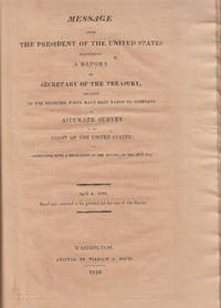
1816rif. 5914Washington DC: William Davis 1816. First Edition. Contemporary half leather. Very good; backstrip powdering; overall toning. Chancery folio I - 8 pp. 2 folding charts; II Indians - 2 3 - 128 pp. 5 folding charts; III Hassler - 4 5 - 10 2 pp. 3 folding charts. The original report by Hassler of his 'buying' trip to Europe in 1811. Hassler was commissioned by Jefferson to undertake the first coast survey. To this end Congress appropriated $50000 for the purchase of instruments. Hassler travelled to Europe but arrived during the wars and was delayed for years. Upon his return this report was issued by the Treasury Dept. that detailed his expenditures for scientific instruments and books as well as chronometers. All the devices makers cost specifications etc. are listed in the report offered here. Hassler's account is bound up with two other Treasury Dept. reports of the same year - separately issued - that provide information on the expenses of the Indian Department and general and particular information on trade with the Indian nations. DSB VI 165-166; DAB VIII 385-386; Poggendorff I 1031. William Davis hardcover books
1763Formato cm. 25x20. Pagine (9), 424, (8). Bella rilegatura in mezza pergamena. Alcune macchie e bruniture ma stato di conservazione molto buono. All'interno sono presenti molte pregevoli incisioni raffiguranti figure geometriche, misurazioni di terreni, botti, balle di fieno, mucchi di grano, altezze di edifici ecc. ed un ritratto ripiegato dell'autore. In fondo sono presenti due lettere del Guerino.
1759rif. 5305Frankfurt & Leipzig: H L Broenner 1759. First Edition. Full contemporary calf raised bands. Very good; spotting throughout. 4to 16 1 - 304 312 correct pp. 24 engraved plates Boehm was a professor of mathematics at the Univ. of Giessen. The book offered here is handbook and manual for surveying accompanied by two appendices that are devoted to surveying over water and underground mine surveying tailored to special needs e.g. driving air shafts. The latter subjects are appended to the text as they pertain to a complete understanding of the science of surveying and were of particular practical use. Boehm's other published books are all in the field of military science artillery etc. and his comments in the Messkunst associate it with his other published work. He appears to have been particularly well informed on the literature of the subject that includes French publications and technically quite adept. He offers suggestions on the construction of special use instruments and apologizes for the omission of any mention of certain kinds of instruments by explaining that they were inaccurate and of little use. In all an excellent treatise on surveying and map making. Poggendorff I 222. H L Broenner hardcover books
1682[Figurato Agrimensura-Matematica] (cm.20,5) ottima piena pergamena molle sec. XVIII, titolo al dorso. -- cc. 6 nn., pp. 551 + 1p. con marca tipografica. Molte illustrazioni n.t. in xilografia di strumenti, schemi, figure ecc. Seconda edizione definitiva più completa della prima del 1603. Molto rara e importante per la vastità di argomenti e notizie. Vedi Riccardi I 478: "Opera interessantissima per la storia dell' aritmetica, ampiamente sviluppata ed applicata anche alla mercatanzia; e per quella della geometria pratica, trovandovisi la descrizione e l' uso degli strumenti allora conosciuti, fra i quali sono notevoli quelli che ora direbbersi celerimensura". Cat. Libri n° 2878-79: "This work is so scarce that it has escaped professor De Morgan. It contains solutions of several indeterminate problems. Amongst the authors quoted by Forestani we find Galigai, Calandri, Lazzisio, Pagani, ecc.". Vecchio restauro al margine del frontis con le prime 5 lettere di (Pratica) ridisegnate. Qualche lieve alone al margine delle prime carte ma esemplare bello nitido e marginoso. * Autori Italiani del '600 1551; * Sotheran Primo Suppl. 1150; * Graesse VIII 309.[f72] Libro
1682[Fig. Agrimensura] (cm.21,5) pieno vitello originale, nervi, dorso in oro con specchi decorati e titolo.-- cc. 6 nn., pp. 551 + 1 p. con marca tipografica. Molte illustrazioni n.t. in xilografia di strumenti, schemi, figure ecc. Seconda edizione definitiva più completa della prima del 1603. Molto rara e importante. Vedi Riccardi I 478: " Opera interessantissima per la storia dell' aritmetica, ampiamente sviluppata ed applicata anche alla mercatanza; e per quella della geometria pratica, trovandosi la descrizione e l' uso degli strumenti allora conosciuti, fra i quali sono notevoli quelli che ora direbbersi di celerimensura". Cat. Libri n° 2878-79: " This Work is so scarce that it has escaped Professor De Morgan. It contains solutions of several indeterminate problems. Amongst the authors quoted by Forestani we find Galigai, Calandri, Lazzisio, Pagani, ecc.". Alcune spellature al dorso e alle cuffie, sei carte (pag. 531) con vecchi strappo restaurato senza perdite, altrimenti esemplare molto bello e nitido. * Autori Italiani del '600 1551; * Sotheran Primo Supplemento 1150; * Graesse VIII 309.[f52] Libro
1815rif. 25378Vergèze 1815 in-folio Manuscrit, reliure plein veau in-folio, mais il ne reste quasiment plus rien du cuir de la reliure initiale, texte manuscrit à l'encre brune, verte et rouge orné de trés nombreuses lettrines calligraphiées en couleurs à l'encre brune, verte et rouge sur toute les pages ainsi que des Calligraphies en ornementation du texte, en bandeaux et culs-de-lampes en couleurs, la Table des matières et sur les 3 dernières pages : Règles d'Arithmétique, collationné complet, 255 pages, Fait à VERGÈZE, le 20 Septembre 1815, chez Mr J. JUEIRAL, signé Auquier (notés en bas de la dernière page avant les pages de Tables),
rif. 83400Ottawa, Lithographed at the Survey Office, 1889, 1 volume in-4 de 265x185 mm environ, 324 pages, demi reliure à coins en cuir noir, dos à 5 nerfs portant titres dorés, orné de filets dorés qui soulignent les nerfs, contient des figures dans le texte et 5 planches hors texte, 1 carte d'envoi de l'auteur. Légères rousseurs sur les pages de garde, petite trace blanche sur le dernier plat, sinon bon état. Un des 50 exemplaires de cette première édition, publiée au sein des Services d'arpentage (Canada), à l'usage des employés de l'équipe. Hommage de l'auteur sous forme de carte. (Nous laissons une enveloppe jointe contenant quelques photographies anciennes sans rapport avec l'ouvrage).
1941rif. 3877Kyiv 1941. Very good. Together 2 views 205 x 325 mm; 8" x 13" printed on cheap thin paper Ad 1: long closed tear through image without loss light staining creasing edges a little frayed; Ad 2: short closed tears along edges two small holes in blank area at lower left light staining. Overall in very condition suitable for exhibition and study. Tragically topical apparently unrecorded views of Kyiv being rude field printings on cheap paper likely created by Nazis during the so-called "First Battle" of Kiev Aug. 23 - Sept. 26 1941 or shortly thereafter. We are mindful that the present views are historically "toxic" but given the context of the current Russian war-crimes against the people of the Ukraine we believe that there is an urgent need for them to be preserved. The first print is a view of Kyiv looking at the city center from the south specifically from the wooded hill of Lysa Hora which had a complex fortification system. During the German occupation the fort became a military plant and tank base. Here Kyiv rises above the Dnipro river on the right. The key below identifies 22 sites mostly of military significance such as buildings bridges power plants hospitals factories churches and cloisters. To each site is assigned a code consisting of a letter or letters and a numeral or numerals: these are certainly map references i.e. K10 L10 F-G7 etc. We have been unable to locate this exact map but large bird's-eye maps of Kyiv taken by the Vermessungs- und Karten-Abteilung survive in the Kiev Polytechnic Museum and also the David Rumsey Collection. That a need for vantage-point views such as ours to accompany such a map seems self-evident. The second is a view of Kyiv taken from the Great Lavra Bell Tower in the Pechersk Lavra monastery strategically positioned in the city center looking towards the Dnieper Valley in the northeast. The key identifies 13 sites likewise militarily important but with the notable inclusion of the "Podol Judenstadt" no. 6 a Jewish neighborhood to the north of the city. Our prints may date before Nov. 3 1941 because on this day just two months into the German occupation of Kyiv a huge explosion brought down the Uspensky Sobor cathedral in the Pechersk Lavra monastery across the courtyard from the Bell Tower from which the present view was drawn. The "Motorized Surveying and Map Detachment" was an integral part of the German military and accompanied the army throughout the European and North African theater. These surveyors photographers and printers traveled with equipment to the front lines sometimes on special trains. The detachments were self-contained and had the capability to print onsite even in the most hostile conditions. Ephemeral views such as the present pair were printed in small numbers for the sole use of German occupying troops. The present prints were purchased by a Munich bookseller from a private collector in Germany along with other documents from the period. NOTA BENE: These prints were both purchased at an auction in Germany in early January 2021 i.e. BEFORE the Russian invasion of Ukraine on February 24 2022. unknown books
rif. Z1-W-023-00989The Stationery Office Books. Used - Acceptable. Used - Acceptable. Sticker on cover. Ships from UK in 48 hours or less usually same day. Your purchase helps support Sri Lankan Children's Charity 'The Rainbow Centre'. Ex-library with wear and barcode page may have been removed. 100% money back guarantee. We are a world class secondhand bookstore based in Hertfordshire United Kingdom and specialize in high quality textbooks across an enormous variety of subjects. We aim to provide a vast range of textbooks rare and collectible books at a great price. Our donations to The Rainbow Centre have helped provide an education and a safe haven to hundreds of children who live in appalling conditions. We provide a 100% money back guarantee and are dedicated to providing our customers with the highest standards of service in the bookselling industry. The Stationery Office Books unknown
1805rif. 45129London, W. Bulmer and Co., 1805. 4to. No wrappers as extracted from ""Philosophical Transactions"" 1805. With titlepage to Phil. Transactions Part I. Pp. 186-197. Having also the titlepage to the volume (Part II, 1805). A few scattered brownspots and very faint browning to outer margins, otherwise fine and wide-margined. A small stamp to verso of titlepage.
1805rif. 45129London W. Bulmer and Co. 1805. 4to. No wrappers as extracted from "Philosophical Transactions" 1805. With titlepage to Phil. Transactions Part I. Pp. 186-197. Having also the titlepage to the volume Part II 1805. A few scattered brownspots and very faint browning to outer margins otherwise fine and wide-margined. A small stamp to verso of titlepage. First printing of probably the first work to discover and correct for the errors of the compass caused by the iron in ships by the first circumnavigator of Australia."Captain Matthew Flinders RN 16 March 1774 - 19 July 1814 was one of the most successful navigators and cartographers of his age. In a career that spanned just over twenty years he sailed with Captain William Bligh circumnavigated Australia and encouraged the use of that name for the continent which had previously been known as New Holland. He survived shipwreck and disaster only to be imprisoned for violating the terms of his scientific passport by changing ships and carrying prohibited papers. He identified and corrected the effect upon compass readings of iron components and equipment on board wooden ships and he wrote what may be the first work on early Australian exploration A Voyage to Terra Australis."Wikepedia unknown
1603[Agrimensura] (cm. 20,5) Bella piena pergamena originale, bel titolo calligrafato al dorso. cc.10nn., cc.344, cc.2, (con marca tipografica ed ultima bianca). Molte illustrazioni in xilografia n.t. di strumenti, schemi, figure ecc. Edizione originale molto rara e importante. Riccardi I 478: "opera interessantissima per la storia dell'aritmetica, ampiamente sviluppata ed applicata anche alla mercatanzia; e per quella della geometria pratica, trovandovisi la descrizione e l'uso degli strumenti allora conosciuti, fra i quali sono notevoli quelli che ora direbbersi di celerimensura". Cat. libri 2878:"This work is so scarce that it has escaped professor de morgan. It contains solution of several indeterminate problems.Amongst the Authors quoted by Forestani we find Galigai, Calandi, Lazzizio, Pagani, ecc." Vecchiolieve resturo al margine bianco del frontis ma esemplare molto bello e nitido. * Parenti prime edizioni 237; *Choix 6632; *Sotheran primo sopplimento 1149; *Brunet II 1341; *Graesse II 615.[f61] Libro
rif. 2805Manuscript 4to. 23.5 x 17.5 cm 2 ff. pencil sketch of arms Marlborough and blank 196 ff. and with 27 drawn folding plates many of which are colored. Bound in contemporary French calf spine gilt in six decorative compartments with title on letterpiece. Excellent with all plates drawn and many some colored in a very professional hand. Very attractive early 18th-century French illustrated manuscript of practical geometry in seven books including individual sections on longimetry planimetry and stereometry—the fundamentals of precision surveying and draftsmanship. The manuscript closely follows but is not identical to Jacques Ozanam's Géométrie Pratique du sr Boulenger Paris 1684 which itself was a revision of La Géométrie pratique Paris 1640 by the mathematician Jean Boulenger. Though the work was reprinted well into the 18th C the present volume seems to follow Ozanam's 1693 edition most closely. Ozanam's book however lacks the drawn and colored figures of the present volume many of which are quite elaborate. The facade of Notre Dame is shown in an exercise for calculating the height of a wall and a segment on proportion features detailed miniature maps of the Brittany coastline identifying towns such as St. Malo and Mont St. Michel. The manuscript exemplifies the early 18th C approach to applied trigonometry—a field that by the mid-17th C was starting to resemble an exact science. Book II defines the common functions sine cosine secant etc.; Book V treats longimetric puzzles such as determining the height of a mountain or a spire or measuring the length of bodies of water; the final two books treat planimetry and stereometry including applied trigonometry—calculating the volumes of real bodies i.e. barrels pipes etc. Those sections of the manuscript that do not appear in Géométrie Pratique—mainly a tract on logarithms and a discussion of surveying instruments—also fall within Ozanam's oeuvre as he published a monograph on compasses in 1673 and a book of logarithmic tables and trigonometric functions in 1685. Jacques Ozanam 1640-1717 was best known for his Récréations mathematiques Paris 1694 which "may be regarded as the forerunner of modern books on mathematical recreations." In addition to Boulenger's work he also revised that of Adriaan Vlacq 1600-1667 and the Jesuit mathematician Claude-François Milliet Dechalles. DSB.10 pp.263-265. [France, early 18th century].
rif. 2805Manuscript 4to. 23.5 x 17.5 cm 2 ff. pencil sketch of arms Marlborough and blank 196 ff. and with 27 drawn folding plates many of which are colored. Bound in contemporary French calf spine gilt in six decorative compartments with title on letterpiece. Excellent with all plates drawn and many some colored in a very professional hand. Very attractive early 18th-century French illustrated manuscript of practical geometry in seven books including individual sections on longimetry planimetry and stereometry—the fundamentals of precision surveying and draftsmanship. The manuscript closely follows but is not identical to Jacques Ozanam's Géométrie Pratique du sr Boulenger Paris 1684 which itself was a revision of La Géométrie pratique Paris 1640 by the mathematician Jean Boulenger. Though the work was reprinted well into the 18th C the present volume seems to follow Ozanam's 1693 edition most closely. Ozanam's book however lacks the drawn and colored figures of the present volume many of which are quite elaborate. The facade of Notre Dame is shown in an exercise for calculating the height of a wall and a segment on proportion features detailed miniature maps of the Brittany coastline identifying towns such as St. Malo and Mont St. Michel. The manuscript exemplifies the early 18th C approach to applied trigonometry—a field that by the mid-17th C was starting to resemble an exact science. Book II defines the common functions sine cosine secant etc.; Book V treats longimetric puzzles such as determining the height of a mountain or a spire or measuring the length of bodies of water; the final two books treat planimetry and stereometry including applied trigonometry—calculating the volumes of real bodies i.e. barrels pipes etc. Those sections of the manuscript that do not appear in Géométrie Pratique—mainly a tract on logarithms and a discussion of surveying instruments—also fall within Ozanam's oeuvre as he published a monograph on compasses in 1673 and a book of logarithmic tables and trigonometric functions in 1685. Jacques Ozanam 1640-1717 was best known for his Récréations mathematiques Paris 1694 which "may be regarded as the forerunner of modern books on mathematical recreations." In addition to Boulenger's work he also revised that of Adriaan Vlacq 1600-1667 and the Jesuit mathematician Claude-François Milliet Dechalles. DSB.10 pp.263-265. [France, early 18th century]. books
1772rif. 2750NANTES 1772 in-folio demi-vélin janséniste un Manuscrit, reliure demi-velin janséniste in-folio, dos 5 nerfs - titre manuscrit à l'encre brune façon Janséniste au dos à l'encre brune, les 3 premières pages ainsi que les deux dernières ont été habilement restaurées en marge sur un centimètre de large lors d'une restauration ancienne, texte manuscrit à l'encre brune orné de trés nombreuses lettrines calligraphiées réhaussées en couleurs sur toute les pages ainsi que des calligraphies en ornementation du texte, en bandeaux et culs-de-lampes réhaussées en couleurs (Thèmes : oiseaux divers, portraits divers, papillons divers, fleurs diverses, lapins divers etc...), orné d'un dessin à l'encre brune réhaussé en couleurs sur la moitié de la page de titre représentant "la manière de tenir la plume" et d'un dessin à l'encre brune réhaussé en couleurs représentant un portrait en pied d'un NÉGOCIANT dans son intérieur devant une Sphère Armilliaire, dessin prenant toute la dernière page , quelques légères piqûres, Table des Matières et sur les dernières pages : Rêgles d'Arithmétique, 545 pages avec une erreur de pagination (mais complet), Fait à Lourmarin, le huitième octobre 1772,
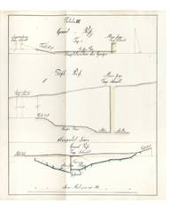
rif. 639640 leaves the final blank. Small folio 332 x 210 mm. orig. paste-paper boards spine & extremities somewhat worn uncut. Clausthal: ca. 1815. A fine and legible manuscript instructional manual on techniques and problems of mine surveying. The text is divided into five chapters: “Von der Vorbereitung zum Markscheiden” “On preparations for measuring the area in which mining may be carried out” “Von Bennenung der Gänge und Klüfte” “On the naming of seams and fissures” “Vom Observiren” “On Observations” “Vom Vermaß oder Verbestimmung eines Grubenfelds” “On measuring and defining a mining claim” and “Von Wasserfällen Wasserleitungen und Tiefbau” “On waterfalls water conduits and underground mining”. This manuscript was probably prepared in 1815 — plate X has the entry “Markscheide 1.7.15“ — at the newly founded mining school at Clausthal the famous mining town of the Harz Mountains in Lower Saxony the fine plates name mining locations in the area. The most attractive plates — all of which contain a number of figures — depict mine shafts mine surveying methods cartographical considerations techniques of prospecting and identification of mineral deposits problems of ownership rights and the constant problems of flooding. All the plates are finely drawn in black ink and have been heightened in grey blue pink and yellow wash. Internally fine. Stamp of Georg Riemschneider 1888-1946 “Oberbergrat” of Clausthal-Zellerfeld. unknown