343 risultati
rif. DADAX1436857171New unknown
rif. DADAX143742841XNew unknown
rif. DADAX1436897505New unknown
rif. DADAX0230221572New unknown
rif. SONG0134604652Used: Good unknown
1770rif. 59178France Paris Undated around 1770. Folio. 425 x 28 cm. Loose sewn 4 by 4 leaves in portfolio with ties. Title-page and 9 pp. written in a fine large legible hand but unidentified in brown ink. Having 5 No 1-5 manuscript maps and plans in double folio with some hand-colouring. On good thick paper clean and fine. unknown
1805rif. 45129London W. Bulmer and Co. 1805. 4to. No wrappers as extracted from "Philosophical Transactions" 1805. With titlepage to Phil. Transactions Part I. Pp. 186-197. Having also the titlepage to the volume Part II 1805. A few scattered brownspots and very faint browning to outer margins otherwise fine and wide-margined. A small stamp to verso of titlepage. First printing of probably the first work to discover and correct for the errors of the compass caused by the iron in ships by the first circumnavigator of Australia."Captain Matthew Flinders RN 16 March 1774 - 19 July 1814 was one of the most successful navigators and cartographers of his age. In a career that spanned just over twenty years he sailed with Captain William Bligh circumnavigated Australia and encouraged the use of that name for the continent which had previously been known as New Holland. He survived shipwreck and disaster only to be imprisoned for violating the terms of his scientific passport by changing ships and carrying prohibited papers. He identified and corrected the effect upon compass readings of iron components and equipment on board wooden ships and he wrote what may be the first work on early Australian exploration A Voyage to Terra Australis."Wikepedia unknown
rif. DADAX0415502977New unknown
rif. DADAX1437009476New unknown
rif. DADAX1436995868New unknown
rif. DADAX0415306620New unknown
rif. DADAX0471165611New unknown
rif. DADAX013615431XNew unknown
rif. DADAX0412805502New unknown
rif. DADAX0548374724New unknown
rif. SONG0976599104ACSM 0000-00-00. Revised Edition. paperback. Used: Good. 0.00x0.00x0.00. Buy with confidence. Excellent Customer Service & Return policy. ACSM paperback
1941rif. 3877Kyiv 1941. Very good. Together 2 views 205 x 325 mm; 8" x 13" printed on cheap thin paper Ad 1: long closed tear through image without loss light staining creasing edges a little frayed; Ad 2: short closed tears along edges two small holes in blank area at lower left light staining. Overall in very condition suitable for exhibition and study. Tragically topical apparently unrecorded views of Kyiv being rude field printings on cheap paper likely created by Nazis during the so-called "First Battle" of Kiev Aug. 23 - Sept. 26 1941 or shortly thereafter. We are mindful that the present views are historically "toxic" but given the context of the current Russian war-crimes against the people of the Ukraine we believe that there is an urgent need for them to be preserved. The first print is a view of Kyiv looking at the city center from the south specifically from the wooded hill of Lysa Hora which had a complex fortification system. During the German occupation the fort became a military plant and tank base. Here Kyiv rises above the Dnipro river on the right. The key below identifies 22 sites mostly of military significance such as buildings bridges power plants hospitals factories churches and cloisters. To each site is assigned a code consisting of a letter or letters and a numeral or numerals: these are certainly map references i.e. K10 L10 F-G7 etc. We have been unable to locate this exact map but large bird's-eye maps of Kyiv taken by the Vermessungs- und Karten-Abteilung survive in the Kiev Polytechnic Museum and also the David Rumsey Collection. That a need for vantage-point views such as ours to accompany such a map seems self-evident. The second is a view of Kyiv taken from the Great Lavra Bell Tower in the Pechersk Lavra monastery strategically positioned in the city center looking towards the Dnieper Valley in the northeast. The key identifies 13 sites likewise militarily important but with the notable inclusion of the "Podol Judenstadt" no. 6 a Jewish neighborhood to the north of the city. Our prints may date before Nov. 3 1941 because on this day just two months into the German occupation of Kyiv a huge explosion brought down the Uspensky Sobor cathedral in the Pechersk Lavra monastery across the courtyard from the Bell Tower from which the present view was drawn. The "Motorized Surveying and Map Detachment" was an integral part of the German military and accompanied the army throughout the European and North African theater. These surveyors photographers and printers traveled with equipment to the front lines sometimes on special trains. The detachments were self-contained and had the capability to print onsite even in the most hostile conditions. Ephemeral views such as the present pair were printed in small numbers for the sole use of German occupying troops. The present prints were purchased by a Munich bookseller from a private collector in Germany along with other documents from the period. NOTA BENE: These prints were both purchased at an auction in Germany in early January 2021 i.e. BEFORE the Russian invasion of Ukraine on February 24 2022. unknown
2000rif. 0901093China Press 2000-01-01. hardcover. Used - Good. Ship out in 2 business day And Fast shipping Free Tracking number will be provided after the shipment.Science Press. 1992. Hardcover. Book Condition: New. 1st Edition. 185x260mm. Language: Chinese and English bilingual 1992/141 pages. Monograph. Satisfaction guaranteedor money back. China Press hardcover
1977rif. 1048707687Carben Surveying Reprints 1977. Hardcover. Good. Pages can have notes/highlighting. Spine may show signs of wear. ~ ThriftBooks: Read More Spend Less.Shelf and handling wear to cover and binding with general signs of previous use. Wear commensurate with age and use. Former owner's name in ink on front endpaper otherwise clean and unmarked copy. Bumping visible to corners of boards and ends of spine strip. Light scuffing and smudging across boards and spine strip. Secure packaging for safe delivery.Dust jacket quality is not guaranteed. Carben Surveying Reprints hardcover
rif. Z1-W-023-00989The Stationery Office Books. Used - Acceptable. Used - Acceptable. Sticker on cover. Ships from UK in 48 hours or less usually same day. Your purchase helps support Sri Lankan Children's Charity 'The Rainbow Centre'. Ex-library with wear and barcode page may have been removed. 100% money back guarantee. We are a world class secondhand bookstore based in Hertfordshire United Kingdom and specialize in high quality textbooks across an enormous variety of subjects. We aim to provide a vast range of textbooks rare and collectible books at a great price. Our donations to The Rainbow Centre have helped provide an education and a safe haven to hundreds of children who live in appalling conditions. We provide a 100% money back guarantee and are dedicated to providing our customers with the highest standards of service in the bookselling industry. The Stationery Office Books unknown
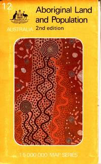
1988rif. 105790Canberra: Department of Aboriginal Affairs. 1988. Large colour folding map 79 x 88 cm in original printed illustrated wraps. Some wear to edges clean very good condition. "Over 92 million hectares or about 12 per cent of the land area of Australia is held by or on behalf of Aborigines. More than two-thirds of this land is freehold the remainder being reserve leasehold or mission land. The map shows all areas of 10 hectares or more - over 4000 parcels of land - and classifies them by size and type of tenure. Also shown are the 415 centres inhabited by 50 or more Aboriginal people." 2nd Edition. Department of Aboriginal Affairs paperback
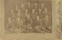
1891rif. List2113Huron 1891. Albumen photograph measuring 5 ½ x 4 inches on larger mount. Some fading very good overall. A scarce and possibly image from the post-statehood Surveyor-General's office. Surveying in the Dakota Territory and in the early statehood period was quite difficult due to the terrain and the abundance of privately held mining claims. This photograph shows an early South Dakota office led by General B.H. Sullivan. Included in the picture is Miss Eva Jackson the Assistant Transcribing Clerk. unknown
rif. 0282628533.Gpaperback. Good. Access codes and supplements are not guaranteed with used items. May be an ex-library book. paperback
rif. 0976599104.Gpaperback. Good. Access codes and supplements are not guaranteed with used items. May be an ex-library book. paperback
1850rif. List1929California 1850. With thirteen letters most multi-page written from Monterey in 1850 a 7 pp facsimile transcription of a 1834 Mexican land grant on cloth measuring 11 x 14 inches and and eleven page document on paper in Spanish relating to a Monterey land grant transcribing an 1841 document. Letters heavily worn with some loss at margins but mostly legible land grant in good to very good condition transcribed document in Spanish in fair condition with water damage to margins. Fair. An interesting archive of 1850s-era material relating to the life and career of the surveyor Edward Williams which recently surfaced in the central mother lode region. The group includes his personal letters from the California Gold Rush as well as well two interesting documents form his work for the Surveyor General J.W. Mandeville in 1858 where he transcribed two Mexican land grants. Lt. Edward Williams was a member of Company E New York Volunteers under Capt. Nelson Taylor. He came to California around 1847 and found employment as a deputy surveyor later working for the Office of the Surveyor General of the Unites States for California. In 1858 Surveyor General J.W. Mandeville commissioned a report on Mexican-era California Land Grants. Mandeville had Williams copy the original documents exactly - inclusive of an ink copy on linen that is an "exact tracing" of the original documents starting with 1834 up through about 1840. These "copies" were submitted to the Surveyor General in 1858 for use in the report. Williams continued the title work by copying other documents from about 1841 though this time not as a tracing but hand copied on the usual blue paper of the 1850s. The documents illustrate the length officials went to while they investigated Mexican Land Grant titles to California properties in the 1850s. The process was difficult and involved two distinctly separate cultures and legal systems that clearly conflicted. The Mexican Government granted rights for these large land parcels in California to various people but clearly stated they could not sell parts of the property. The wording was used many times in litigation of the period in both defense of the land grants and in opposition to how the land grants were handled. The issues were actually quite simple in that the Mexican legal standards for land grants was far different from those in the United States and the two differing forms of written land ownership and use clashed. These documents reflect a parcel of land granted to Francisco Mesa at "Corral de Tierra" a large parcel in Monterrey County California. Mesa had requested land for "his personal use and that of his family." In the Grant the title papers reflect "while the land is under Francisco's possession it cannot be divided mortgaged or a levy placed on it nor handed down." These original documents help illustrate the complex story of Mexican Land Grants in California. Also included are thirteen letters from Ed aka "Ned" to various family members primarily his mother and sister Alice and vice versa. About half are from Ed the other half are written to him. The dates of the letters are; 1850: February 10th April 15th April 16th April 28th June 10th July 30th October 11th and November 17th and 1851: September 9th. One undated letter with heavy loss is written from Panama. The letters are generally readable but the condition far from perfect with water stains throughout and chips abundant along edges and significant textual loss. The letters are generally at least two pages sometimes four or more inclusive of writing in the crossed line custom to save paper. Most are datelined at Monterrey where he discusses the people the customs setting and more. Despite the condition flaws there is much to be gleaned from his correspondence. In his April 15 1850 letter . he describes his trip to San Juan Bautista from Monterrey in detail while he was on his way to San Francisco. Williams writes of his great pleasure on tasting cooked beef by the Indians that he found was the best he ever tasted as they camped on the way to San Jose with the ultimate goal Mission Dolores in San Francisco: “this the beef they put on the embers of the fire and broiled it - I never tasted anything like it before so tender so juicy…” One of his first notes on San Francisco: "There are regular streets filled with all kinds of sorts of stores… The shipping covers the water as far as you can see. And those nearest the shore are converted into store houses the rigging being taken down and the and holes cut in the sides for doors.The best houses in town are occupied by gamblers . a large saloon filled with tables on which are played all kinds of games of chance - at some of the tables are displayed immense amounts of coin and gold in lumps worth from 1 to 5000 dollars which some poor infatuated fool of a miner has at some time lost to them." In his letter of April 16th he discusses both his difficulties with women in California and his lack of fitting in back east: “The Spanish Girls are very nice and all that sort of thing but the trouble is to find one that is educated. I can’t bear an uneducated wom an and I think I shall have to come to N.Y. and bring one out here… I know one or two in N.Y. but I don’t believe they would have such an uncouth specimen of an ‘hombre’ as me…” In his next letter he describes Carmel in detail. He states: “I haven’t been to the mines nor have I any inclination to go” though he intends to settle in California permanently. In his next letter he discusses the people he’s met and how he detests the anglophone community there: “How do I like the People Those of Spanish whom I call my friends I love with all my soul - there is not much society except among them… the Eng. and Am. population I detest from the bottom of my heart. This may sound strange but you will know the por que when you arrive.” He then praises the climate and scenery of Monterey. One letter written from Panama which has unfortunately sustained heavy losses at margins offers some details of the trip on the Chagres River. The replies to Williams from his family offer details on life in New York and are similarly compromised in condition but overall there is enough to glean from the group to provide a detailed example of family correspondence from the period. Overall a very interesting and unusual archive of a young professional who moved to California during the Gold Rush period and rejected the Anglophone mining community with particular interest to historians of Monterey and of the systems of land grants that shaped Mexican and American land policy in the nineteenth century. unknown