Rapin-Thoyras, Paul DeBiblio.com

30 résultats
réf. 1247786234.Gpaperback. Good. Access codes and supplements are not guaranteed with used items. May be an ex-library book. paperback
réf. 1345616333.Ghardcover. Good. Access codes and supplements are not guaranteed with used items. May be an ex-library book. hardcover
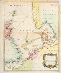
1744réf. 52524London. 1744. A nicely coloured and most attractive chart of the North Sea and English Channel from the Channel Islands in the south to the Shetland Islands in the north. Produced for Mr Tindal's Continuation of Rapin's History Copper engraving. In fine condition Hand coloured. Size: 37.5 x 47 cm. unknown
réf. 1142352943.Gpaperback. Good. Access codes and supplements are not guaranteed with used items. May be an ex-library book. paperback
réf. 1018802436.Gpaperback. Good. Access codes and supplements are not guaranteed with used items. May be an ex-library book. paperback