Gregory, Dick, with Shelia P MosesBiblio.com

11 201 résultats
2001réf. 29523Atlanta: Longstreet Press. 2001. Third Printing. Hardcover. A fine copy in near fine dust jacket with crease on lower corner of front dust jacket flap. Signed and inscribed by the author. ; 8vo 8" - 9" tall; 301 pp . Longstreet Press hardcover
1996réf. G1570733511I4N00American Bar Association 1996. Paperback. Very Good. May have limited writing in cover pages. Pages are unmarked. ~ ThriftBooks: Read More Spend Less.Dust jacket quality is not guaranteed. American Bar Association paperback
réf. B9789042038059Paperback / softback. New. To a world assaulted by private interests this book argues that peace must be a public thing. Distinguished philosophers of peace have always worked publicly for public results. Opposing nuclear proliferation organizing communities of the disinherited challenging violence within status quo establishments such are the legacies of truly engaged philosophers of peace. This volume remembers those legacies reviews the promise of critical thinking for crises today and expands the free range of thinking needed to create more mindful and peaceful relations. With essays by committed peace philosophers this volume shows how public engagement has been a significant feature of peace philosophers such as Camus Sartre Dewey and Dorothy Day. Today we also confront historical opportunities to transform practices for immigration police interrogation and mental health as we seek to sustain democracies of increasing multicultural diversity. In such cases our authors consider points of view developed by renowned thinkers such as Weil Mouffe Conway and Martín-Baró. This volume also presents critical analysis of concepts for thinking about violence reconsiders Plato’s philosophy of justice and examines the role of ethical theory for liberation struggles such as Occupy! paperback
1957This is an about very good hardcover copy in dark blue cloth boards with title in gilt on the front cover. Very clean inside and out. Top right corners of boards worn. Internally very clean, some handling of the pages, not crisp. This was the first catalog published by the Greenwich Gallery located in Greenwich Village, on 71 Washington Place, in the area around New York University, which itself surrounds Washington Square Park. The exhibition featured paintings and sculpture by 50 American contemporary artists. Many of them immigrants from Russia or Eastern Europe, many Jewish. The gallery intended to show American modern, but representational or figurative art. They included: Milton Avery, Saul Baizerman, Isabel Bishop, Byron Browne, Charles Burchfield, David Burliuk, Doris Caesar, Jose de Creeft, Philip Evergood, William Gropper, Chaim Gross, George Grosz, Edward Hopper, Leon Kroll, Jack Levine, Jacques Lipchitz, Georgia O'Keefe, Henry Varnum Poor, Larry Rivers, Ben Shahn, the Soyer brothers Raphael, Isaac and Moses, Abraham Walkowitz, Max Weber, Andrew Wyeth and William Zorach, among many others. Each artist gets two pages: one biographical information and a black & white illustration. Essay by A.L. Chanin. 10" high X 7" wide. This book will be securely packed and shipped with tracking.
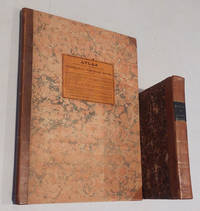
1829réf. 49267Portland: Shirley and Hyde 1829. First edition. The title page of Greenleaf's 1829 . Portland: Shirley and Hyde 1829. First edition. The title page of Greenleaf's 1829 "Survey" says it is "Illustrated by Maps." In fact these maps are in a separate atlas published without a title page. "Atlas Accompanying Greenleaf's Map and Statistical Survey of Maine." Contents as follows:1. Orthographic projection of the situation of the mountain and highland ranges particularly in the northern part of the State.2. 10 Vertical projections of the elevation of the northern and eastern boundary line with those of sections across the State from the Atlantic to the St. Lawrence; and the comparative declivities of the principal rivers.3. Sketch of the British map got up during the late war with a view to raise pretence for a claim to a new boundary.4. Maps of the British surveyors under the treaty of Ghent shewing their pretended ranges of highlands across the State. The 4 preceding Maps are designed to exhibit the true merits of the question of the disputed boundary as far as it is affected by the direction and elevation of the highlands.5. Map of the original grants and sales of land under which the titles are now holden -- from the earliest dates to the latest divisions of land between Maine and Massachusetts.6. Map exhibiting the progress present density and distribution of population and wealth; and the present representative districts.7. A comparative view of the climate of Maine and others of the United States and of England exhibited in a series of diagrams of the monthly means and extremes of temperature."Greenleaf was as in many of his endeavors ahead of his time in publishing an atlas devoted to an individual state. This atlas was preceded only by Robert Mill's 1825 Atlas of the State of South Carolina and David Burr's 1829 Atlas of the State of New York and it was not until many years later that another such state atlas appeared." - Ed Thompson "Important Maine Maps." "Atlas" and The book "Survey of the State of Maine" and its accompanying atlas brought $7475 and $546 respectively in Thompson's 2003 auction. The two items offered here are in superior condition to Thompson's copies. "Survey" is bound in contemporary half calf over marbled boards and has a black spine label with gold lettering. Minor rubbing to covers and foxing in text but a very good condition of a rare book. The atlas also bound in half calf over marbled boards has a printed paper cover label. The maps show some old repairs along folds but are in very good condition. Laid into the atlas is a two-sheet manuscript "Map of Township B. Surveyed by D. Parker Esq." Done in sepia ink and pencil. 40 x 32 cm. 21.5 cm. viii 468 pp. and 33.5 cm. Seven folding hand colored maps. . Shirley and Hyde hardcover books
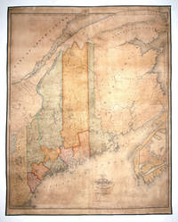
1829réf. 8887Portland 1829. No Binding. Very Good. 50 ¾ x 40 ¼ inches. Steel engraving. Original wash color refreshed; expertly conserved re-mounted on new linen; a few cracks & marginal mends but fine for this kind. The very rare three copies cited in OCLC first edition of this excellent map of Maine by the state's first mapmaker. An exceptionally well-preserved example. Unlike many early American state maps that struggled to get completed Greenleaf's received a warm commendation from the state legislature even before it was published and the mapmaker was granted $1000 to aid him in finishing the map. Greenleaf later received $640 from the legislature for 40 copies of the map that were obtained for state use a remarkable $16 per copy. Perhaps the large number of copies sold for official rather than private use helps account for the map's present rarity. The map was originally intended to accompany an atlas and survey of the state that Greenleaf published the same year but very few complete sets of the three items are known to have survived. Greenleaf appears to have taken special care in the production of this map. Although published in Portland Maine Greenleaf employed as engravers for this work the estimable J. H. Young and F. Dankworth both of whom produced major works for the firms of S. A. Mitchell and others. This precisely detailed map which shows ten counties in different colors provides state county town and township boundary lines. The state's many rivers lakes ponds and even falls are shown as are roads and elevations. The map was re-published in 1844 by Greenleaf's son and namesake from the same plates but with emendations and several times thereafter. Greenleaf published two earlier maps of the state in 1815 and 1820 but the present work was by far his finest. Ristow W. American Maps and Mapmakers pp. 95-96; Catalogue Raisonne Important Maine Maps. Auction Catalogue for Thompson Collection Auction Robert E. Croul 2003 lot 119. unknown books
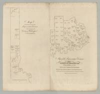
réf. 6460Portland ca 1832. Engraving 13.5” x 14.5” sheet size. Previously unrecorded map by Moses Greenleaf of Washington County Maine intended for a never-realized second volume of his Survey of the State of Maine. The map is stripped to its essentials showing Washington County and its state-representative districts in outline presumably based on reapportionment following the Census of 1830. The voting population for each town and unincorporated “plantation” is given though only in the northern part of the county at left are their boundaries delineated. Given the map’s purely political purpose Greenleaf has entirely eschewed the topographical detail of his earlier maps of the state. The map’s unfinished appearance suggests it might be an early proof particularly when it is compared with a companion map of York County also produced by Greenleaf at the time and presently known in a single example discussed below. Moses Greenleaf Greenleaf was a towering figure in the mapping of the state of Maine devoting his life to ever-improved mapping of the region. The pinnacle of his career came in 1829 when he published his new and substantially updated wall map of Maine. This was complemented by a text volume A Survey of the State of Maine and accompanying atlas the first atlas of the state and the third of any state of the Union. The map is a remarkable achievement widely heralded but the Survey of the State of Maine is also of the first importance a wide-ranging summation of the present state of Maine particularly valuable for commercial and economic data. Greenleaf however ever the perfectionist acknowledged the deficiencies of the work and announced his intention of issuing a second volume: “…it was intended to devote some portion of the work to a distinct consideration of the absolute and relative wealth of the State and its different component parts – value and importance of its lands – facilities for – kinds extent and expediency of internal improvements and its general resources; but the time when the publication must be completed was limited and an important part of the materials for these subjects could not be obtained until after this time. It was thought better therefore to omit their introduction altogether for the present; in the hope that circumstances will permit at a future time a more extended notice of them and under greater advantages for useful results than was possible at present.” Preface to A Survey of the State of Maine The largest single handicap to Greenleaf’s career was simply that the market for high-quality maps of Maine was too small for his projects to be commercially viable. Consider for example the 1829 wall map text volume and atlas which had cost him six years of his time and more than $12000 out of pocket for surveys engraving printing &c. He had 565 sets printed and offered by advance subscription at $16 a set but by early 1830 barely 100 of these had been sold. At this point though only after much debate the State rescued him by stepping in and purchased 400 sets at the full subscription price. Seemingly undeterred by the parlous financial prospects of the project and by the number of sets still in circulation Greenleaf continued to work on improving his materials. In 1832 he republished the wall-map of Maine but very few examples of that printing can be traced. In parallel our map and the companion map of York County mentioned earlier are the only known evidence that Greenleaf started work on his projected second volume of the Survey of the State of Maine Although there might be reference amongst the papers in the Moses Greenleaf archive in the Maine State Archives. Unfortunately the volume was never completed – and it may not even have advanced very far – possibly due to Greenleaf’s financial struggles but certainly ending with Greenleaf’s death on March 20 1834 aged fifty-six. Rarity and references We are aware of an example recently acquired by the Osher Map Library but the map is absolutely unrecorded in the general bibliographic literature the specialized biographical and bibliographical literature on Greenleaf and the mapping of Maine and the standard databases for the antiquarian market. It must be noted however that we acquired five examples in a large lot of Greenleaf material purchased by a third party at a Vermont auction in 2020. Not in OCLC; Phillips Maps of America; Walter Macdougall Settling the Maine Wilderness Wilderness – Moses Greenleaf His Maps and His Household of Faith 1777-1834 2006; Edgar Crosby Smith Moses Greenleaf Maine’s first map-maker a biography … also a bibliography of the maps of Maine 1903; Edward Thompson Important Maine Maps Books Prints and Ephemera 2003; or Thompson Printed Maps of the District and State of Maine 1793-1860 2010. Neither Antique Map Price Record nor Rare Book Hub show any record of the map having appeared on the antiquarian market. Macdougall Smith and Thompson all provided useful background on Greenleaf and his work. It is also worth noting that Greenleaf’s companion map of the representative districts of York County see Thompson Printed Maps of the District and State of Maine p.96 is recorded in but a single example in the Benton L. Hatch Collection in the University of Maine’s Fogler Library Special Collections See Thompson Printed Maps of the District and State of Maine pp. 96-97. Hatch was Associate Librarian for Special Collections at the University of Massachusetts who built a substantial collection of material on the history of Maine and Massachusetts. In view of his lifetime interest it seems likely that given the opportunity he would have acquired any others of the series he encountered. Appendix: An accounting of Greenleaf’s 1829 project A rough balance sheet for the 1829 publications can be reconstructed from contemporary documents. The wall-map and text volume with atlas were offered by advance subscription at $16 a set. A report of proceedings in the state legislature recorded that “It appears that Mr. G. was induced by encouragement from the Legislature to extend his original plan and incur great additional expense in order to present a work more valuable to the state. The engraving printing &c. cost $8351 81 surveys &c. about 4000 and Mr. G has devoted more than 6 years of his time to the work. The Legislature of 1828 granted $1000 to aid him in his labors. 565 copies were printed of which 458 remain unsold.” Hallowell American Advocate February 27 1830. A second report estimated that Greenleaf’s personal contribution be valued at $9000 Portland Christian Monitor February 25 1830. This gives as a rough guide income of $2700 against an actual cost of $12350 or a notional cost of $21350. In view of the scale of the loss Greenleaf made an appeal for relief submitting a lengthy memorial in January 1830 Maine State Archives. After much debate in the legislature it was agreed that the state would purchase 400 sets at the subscription price of $16 and the state would give Greenleaf a “a notice for $2000 redeemable in no longer time than 15 years and to be paid out of the proceeds of the Public Lands” Portland Eastern Argus February 26 1830. While the Maine government acted partly out of realization of a debt of honor to Greenleaf there was also a general feeling that the success of Greenleaf’s mapping project would bring all manner of benefits not least in driving land sales by the state. However the state also ended up with more copies than it could use so there was a heavy drive to sell sets to the school districts in particular and offices and officers of state at Washington Hallowell American Advocate January 21 1832 but also to gift sets to to Maine’s representatives in Congress to all the other states and so on. CONDITION: Very good light foxing and creasing small hole in maring at top of vertical fold. Offered in partnership with Boston Rare Maps. [Portland, ca 1832] unknown books
2011réf. DADAX1240909675British Library Historical Print Editions 2011-01-01. paperback. New. 7.44x0.98x9.69. Buy with confidence. Excellent Customer Service & Return policy. British Library, Historical Print Editions paperback
réf. 12248276like new. unknown
1829réf. 49267Portland: Shirley and Hyde 1829. First edition. The title page of Greenleaf's 1829 . Portland: Shirley and Hyde 1829. First edition. The title page of Greenleaf's 1829 "Survey" says it is "Illustrated by Maps." In fact these maps are in a separate atlas published without a title page. "Atlas Accompanying Greenleaf's Map and Statistical Survey of Maine." Contents as follows:1. Orthographic projection of the situation of the mountain and highland ranges particularly in the northern part of the State.2. 10 Vertical projections of the elevation of the northern and eastern boundary line with those of sections across the State from the Atlantic to the St. Lawrence; and the comparative declivities of the principal rivers.3. Sketch of the British map got up during the late war with a view to raise pretence for a claim to a new boundary.4. Maps of the British surveyors under the treaty of Ghent shewing their pretended ranges of highlands across the State. The 4 preceding Maps are designed to exhibit the true merits of the question of the disputed boundary as far as it is affected by the direction and elevation of the highlands.5. Map of the original grants and sales of land under which the titles are now holden -- from the earliest dates to the latest divisions of land between Maine and Massachusetts.6. Map exhibiting the progress present density and distribution of population and wealth; and the present representative districts.7. A comparative view of the climate of Maine and others of the United States and of England exhibited in a series of diagrams of the monthly means and extremes of temperature."Greenleaf was as in many of his endeavors ahead of his time in publishing an atlas devoted to an individual state. This atlas was preceded only by Robert Mill's 1825 Atlas of the State of South Carolina and David Burr's 1829 Atlas of the State of New York and it was not until many years later that another such state atlas appeared." - Ed Thompson "Important Maine Maps." "Atlas" and The book "Survey of the State of Maine" and its accompanying atlas brought $7475 and $546 respectively in Thompson's 2003 auction. The two items offered here are in superior condition to Thompson's copies. "Survey" is bound in contemporary half calf over marbled boards and has a black spine label with gold lettering. Minor rubbing to covers and foxing in text but a very good condition of a rare book. The atlas also bound in half calf over marbled boards has a printed paper cover label. The maps show some old repairs along folds but are in very good condition. Laid into the atlas is a two-sheet manuscript "Map of Township B. Surveyed by D. Parker Esq." Done in sepia ink and pencil. 40 x 32 cm. 21.5 cm. viii 468 pp. and 33.5 cm. Seven folding hand colored maps. . Shirley and Hyde hardcover
réf. 1178951375.Gpaperback. Good. Access codes and supplements are not guaranteed with used items. May be an ex-library book. paperback
réf. 1018029222.Ghardcover. Good. Access codes and supplements are not guaranteed with used items. May be an ex-library book. hardcover
réf. 101803420X.Gpaperback. Good. Access codes and supplements are not guaranteed with used items. May be an ex-library book. paperback
réf. 1240909675.Gpaperback. Good. Access codes and supplements are not guaranteed with used items. May be an ex-library book. paperback
1829réf. 8887Portland 1829. No Binding. Very Good. 50 ¾ x 40 ¼ inches. Steel engraving. Original wash color refreshed; expertly conserved re-mounted on new linen; a few cracks & marginal mends but fine for this kind. The very rare three copies cited in OCLC first edition of this excellent map of Maine by the state's first mapmaker. An exceptionally well-preserved example. Unlike many early American state maps that struggled to get completed Greenleaf's received a warm commendation from the state legislature even before it was published and the mapmaker was granted $1000 to aid him in finishing the map. Greenleaf later received $640 from the legislature for 40 copies of the map that were obtained for state use a remarkable $16 per copy. Perhaps the large number of copies sold for official rather than private use helps account for the map's present rarity. The map was originally intended to accompany an atlas and survey of the state that Greenleaf published the same year but very few complete sets of the three items are known to have survived. Greenleaf appears to have taken special care in the production of this map. Although published in Portland Maine Greenleaf employed as engravers for this work the estimable J. H. Young and F. Dankworth both of whom produced major works for the firms of S. A. Mitchell and others. This precisely detailed map which shows ten counties in different colors provides state county town and township boundary lines. The state's many rivers lakes ponds and even falls are shown as are roads and elevations. The map was re-published in 1844 by Greenleaf's son and namesake from the same plates but with emendations and several times thereafter. Greenleaf published two earlier maps of the state in 1815 and 1820 but the present work was by far his finest. Ristow W. American Maps and Mapmakers pp. 95-96; Catalogue Raisonne Important Maine Maps. Auction Catalogue for Thompson Collection Auction Robert E. Croul 2003 lot 119. unknown
réf. 6460Portland ca 1832. Engraving 13.5” x 14.5” sheet size. Previously unrecorded map by Moses Greenleaf of Washington County Maine intended for a never-realized second volume of his Survey of the State of Maine. The map is stripped to its essentials showing Washington County and its state-representative districts in outline presumably based on reapportionment following the Census of 1830. The voting population for each town and unincorporated “plantation” is given though only in the northern part of the county at left are their boundaries delineated. Given the map’s purely political purpose Greenleaf has entirely eschewed the topographical detail of his earlier maps of the state. The map’s unfinished appearance suggests it might be an early proof particularly when it is compared with a companion map of York County also produced by Greenleaf at the time and presently known in a single example discussed below. Moses Greenleaf Greenleaf was a towering figure in the mapping of the state of Maine devoting his life to ever-improved mapping of the region. The pinnacle of his career came in 1829 when he published his new and substantially updated wall map of Maine. This was complemented by a text volume A Survey of the State of Maine and accompanying atlas the first atlas of the state and the third of any state of the Union. The map is a remarkable achievement widely heralded but the Survey of the State of Maine is also of the first importance a wide-ranging summation of the present state of Maine particularly valuable for commercial and economic data. Greenleaf however ever the perfectionist acknowledged the deficiencies of the work and announced his intention of issuing a second volume: “…it was intended to devote some portion of the work to a distinct consideration of the absolute and relative wealth of the State and its different component parts – value and importance of its lands – facilities for – kinds extent and expediency of internal improvements and its general resources; but the time when the publication must be completed was limited and an important part of the materials for these subjects could not be obtained until after this time. It was thought better therefore to omit their introduction altogether for the present; in the hope that circumstances will permit at a future time a more extended notice of them and under greater advantages for useful results than was possible at present.” Preface to A Survey of the State of Maine The largest single handicap to Greenleaf’s career was simply that the market for high-quality maps of Maine was too small for his projects to be commercially viable. Consider for example the 1829 wall map text volume and atlas which had cost him six years of his time and more than $12000 out of pocket for surveys engraving printing &c. He had 565 sets printed and offered by advance subscription at $16 a set but by early 1830 barely 100 of these had been sold. At this point though only after much debate the State rescued him by stepping in and purchased 400 sets at the full subscription price. Seemingly undeterred by the parlous financial prospects of the project and by the number of sets still in circulation Greenleaf continued to work on improving his materials. In 1832 he republished the wall-map of Maine but very few examples of that printing can be traced. In parallel our map and the companion map of York County mentioned earlier are the only known evidence that Greenleaf started work on his projected second volume of the Survey of the State of Maine Although there might be reference amongst the papers in the Moses Greenleaf archive in the Maine State Archives. Unfortunately the volume was never completed – and it may not even have advanced very far – possibly due to Greenleaf’s financial struggles but certainly ending with Greenleaf’s death on March 20 1834 aged fifty-six. Rarity and references We are aware of an example recently acquired by the Osher Map Library but the map is absolutely unrecorded in the general bibliographic literature the specialized biographical and bibliographical literature on Greenleaf and the mapping of Maine and the standard databases for the antiquarian market. It must be noted however that we acquired five examples in a large lot of Greenleaf material purchased by a third party at a Vermont auction in 2020. Not in OCLC; Phillips Maps of America; Walter Macdougall Settling the Maine Wilderness Wilderness – Moses Greenleaf His Maps and His Household of Faith 1777-1834 2006; Edgar Crosby Smith Moses Greenleaf Maine’s first map-maker a biography … also a bibliography of the maps of Maine 1903; Edward Thompson Important Maine Maps Books Prints and Ephemera 2003; or Thompson Printed Maps of the District and State of Maine 1793-1860 2010. Neither Antique Map Price Record nor Rare Book Hub show any record of the map having appeared on the antiquarian market. Macdougall Smith and Thompson all provided useful background on Greenleaf and his work. It is also worth noting that Greenleaf’s companion map of the representative districts of York County see Thompson Printed Maps of the District and State of Maine p.96 is recorded in but a single example in the Benton L. Hatch Collection in the University of Maine’s Fogler Library Special Collections See Thompson Printed Maps of the District and State of Maine pp. 96-97. Hatch was Associate Librarian for Special Collections at the University of Massachusetts who built a substantial collection of material on the history of Maine and Massachusetts. In view of his lifetime interest it seems likely that given the opportunity he would have acquired any others of the series he encountered. Appendix: An accounting of Greenleaf’s 1829 project A rough balance sheet for the 1829 publications can be reconstructed from contemporary documents. The wall-map and text volume with atlas were offered by advance subscription at $16 a set. A report of proceedings in the state legislature recorded that “It appears that Mr. G. was induced by encouragement from the Legislature to extend his original plan and incur great additional expense in order to present a work more valuable to the state. The engraving printing &c. cost $8351 81 surveys &c. about 4000 and Mr. G has devoted more than 6 years of his time to the work. The Legislature of 1828 granted $1000 to aid him in his labors. 565 copies were printed of which 458 remain unsold.” Hallowell American Advocate February 27 1830. A second report estimated that Greenleaf’s personal contribution be valued at $9000 Portland Christian Monitor February 25 1830. This gives as a rough guide income of $2700 against an actual cost of $12350 or a notional cost of $21350. In view of the scale of the loss Greenleaf made an appeal for relief submitting a lengthy memorial in January 1830 Maine State Archives. After much debate in the legislature it was agreed that the state would purchase 400 sets at the subscription price of $16 and the state would give Greenleaf a “a notice for $2000 redeemable in no longer time than 15 years and to be paid out of the proceeds of the Public Lands” Portland Eastern Argus February 26 1830. While the Maine government acted partly out of realization of a debt of honor to Greenleaf there was also a general feeling that the success of Greenleaf’s mapping project would bring all manner of benefits not least in driving land sales by the state. However the state also ended up with more copies than it could use so there was a heavy drive to sell sets to the school districts in particular and offices and officers of state at Washington Hallowell American Advocate January 21 1832 but also to gift sets to to Maine’s representatives in Congress to all the other states and so on. CONDITION: Very good light foxing and creasing small hole in maring at top of vertical fold. Offered in partnership with Boston Rare Maps. [Portland, ca 1832] unknown
réf. 0913764000.Ghardcover. Good. Access codes and supplements are not guaranteed with used items. May be an ex-library book. hardcover
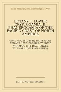
2026réf. LRB17000984Paris: Editions Recreasoft 2026 Language: English. Approximately 520 pages. English : Print-on-demand reprint. Original edition : 1862. A botanical compilation covering the lower Cryptogamia and the phanerogamous plants of the Pacific Coast of North America. The volume includes contributions on Musci Lichenes Algae Fungi and Phanerogamia with authorial sections by leading 19th-century botanists. Of particular interest for studies of North American flora cryptogamic botany and the scientific work associated with the United States exploring expeditions. Book images are non-contractual. Editions Recreasoft. Softcover. New. Editions Recreasoft paperback
2005réf. Q-0007205384Harpercollins Pub Ltd 2005-05-31. Paperback. New. In shrink wrap. Looks like an interesting title! Harpercollins Pub Ltd paperback
2001réf. Q-0764119648B.E.S. Publishing 2001-08-01. Paperback. New. In shrink wrap. Looks like an interesting title! B.E.S. Publishing paperback
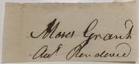
1785réf. 2791581785. unbound. very good. 1 x 2.5-inch signature removed from a document no place no date circa 1785. Smudged ink on the first letter of his name but still in very good condition overall. American patriot and religious leader best remembered for his participation in the Boston Tea Party. unknown books
1785réf. 2791581785. unbound. very good. 1 x 2.5-inch signature removed from a document no place no date circa 1785. Smudged ink on the first letter of his name but still in very good condition overall. American patriot and religious leader best remembered for his participation in the Boston Tea Party. unknown
réf. 67403286-6Elgar Publishing Incorporated Edward. Used - Good. Pages intact with minimal writing/highlighting. The binding may be loose and creased. Dust jackets/supplements are not included. Stock photo provided. Product includes identifying sticker. Better World Books: Buy Books. Do Good. Elgar Publishing, Incorporated, Edward unknown
réf. mon0000294065Edward Elgar Publishing Ltd 29/12/2017 00:00:01. hardcover. New. 1.7986 in x 24.0817 in x 16.0878 in. Edward Elgar Publishing Ltd hardcover
2017réf. __1785369962Edward Elgar Pub 2017. Hardcover. New. 257 pages. 9.25x6.25x0.75 inches. Edward Elgar Pub hardcover