10.974 resultados
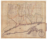
ref. 3387Hartford: Published under the Authority of The General Assembly By Hudson & Goodwin 1812 or 1813. Engraved By Abner Reed E. Windsor. Hand-colored engraving 36.5" x 44.25" plus margins dissected and mounted on linen folding into original 8vo covers half red leather and marbled paper boards gilt title "Connecticut" and gilt rules at spine. CONDITION: Good spotting mainly in the lower left quadrant which seems to be endemic to case map examples as evident in copies at Harvard and the Library of Congress which can be viewed online. The first state of this scarce important and very fine map of Connecticut offered here in desirable case map form with beautiful original color. This large and impressive map depicts the entire state of Connecticut as well as narrow portions of adjacent states the whole of Long Island Sound and part of Long Island. A circular cartouche incorporating the Connecticut coat-of-arms appears in the lower right corner along with a fine calligraphic dedication to Governor Roger Griswold. A handsome compass rose with a fleur-de-lis directional is situated in Long Island Sound near New Haven. A key in the upper left margin identifies some thirty-five points of interest including churches academies court houses gun & pistol factories paper mills distilleries glass works ore beds light houses etc. The last item listed is "Humphrysville - The first extensive successful woolen mill in the country." According to Thompson there is an apparently later state of the map in which this note had been transferred to the site of present day Seymour. Also noted by Thompson are the turnpike roads a recent development and apparently the first to appear on an American map. Warren & Gillett undertook the first survey of the state since William Blodget's map of 1792 carrying out much of the field work themselves but also as Ristow points out likely incorporating manuscript maps from local surveyors as well as other locally provided data. "Though the publication of this map was a private venture the survey had an official sanction. At the May session 1811 of the Connecticut legislature a resolution was passed authorizing Hudson & Goodwin 'at their own expense to prepare and publish from actual survey a map of this state and for that purpose the petitioners are authorised.to pass over the land of individuals in the state.and empowered to examine the records of the state'" Thompson. As the authoritative map of the state the Warren & Gillet map served as the prototype for other maps of Connecticut into the 1840s. Although cataloged by Thompson and others as 1812 the date of publication of this map is somewhat unclear. The inscription to Governor Griswold reads in part "Respectfully Inscribed By the Publishers. Hartford February 1812" but the copyright date is 1813. Also the last governor listed is John Cotton Smith who succeeded Griswold in 1813. Moses Warren 1762-1835 was born in Hopkinton Rhode Island but soon moved with his family to East Lyme Connecticut. He served as a sergeant in the Revolutionary War and surveyed the Western Reserve in 1796. Warren's partner George Gillet 1771-1853 was born in Hebron Connecticut. He was appointed surveyor general of Connecticut following publication of this map. A splendid early map of Connecticut. REFERENCES: Thompson Maps of Connecticut 52; Ristow American Maps & Mapmakers pp. 96-98. Hartford: Published under the Authority of The General Assembly, By Hudson & Goodwin, 1812 [or 1813]. Engraved By Abner Reed, E. unknown books
ref. 3387Hartford: Published under the Authority of The General Assembly By Hudson & Goodwin 1812 or 1813. Engraved By Abner Reed E. Windsor. Hand-colored engraving 36.5" x 44.25" plus margins dissected and mounted on linen folding into original 8vo covers half red leather and marbled paper boards gilt title "Connecticut" and gilt rules at spine. CONDITION: Good spotting mainly in the lower left quadrant which seems to be endemic to case map examples as evident in copies at Harvard and the Library of Congress which can be viewed online. The first state of this scarce important and very fine map of Connecticut offered here in desirable case map form with beautiful original color. This large and impressive map depicts the entire state of Connecticut as well as narrow portions of adjacent states the whole of Long Island Sound and part of Long Island. A circular cartouche incorporating the Connecticut coat-of-arms appears in the lower right corner along with a fine calligraphic dedication to Governor Roger Griswold. A handsome compass rose with a fleur-de-lis directional is situated in Long Island Sound near New Haven. A key in the upper left margin identifies some thirty-five points of interest including churches academies court houses gun & pistol factories paper mills distilleries glass works ore beds light houses etc. The last item listed is "Humphrysville - The first extensive successful woolen mill in the country." According to Thompson there is an apparently later state of the map in which this note had been transferred to the site of present day Seymour. Also noted by Thompson are the turnpike roads a recent development and apparently the first to appear on an American map. Warren & Gillett undertook the first survey of the state since William Blodget's map of 1792 carrying out much of the field work themselves but also as Ristow points out likely incorporating manuscript maps from local surveyors as well as other locally provided data. "Though the publication of this map was a private venture the survey had an official sanction. At the May session 1811 of the Connecticut legislature a resolution was passed authorizing Hudson & Goodwin 'at their own expense to prepare and publish from actual survey a map of this state and for that purpose the petitioners are authorised.to pass over the land of individuals in the state.and empowered to examine the records of the state'" Thompson. As the authoritative map of the state the Warren & Gillet map served as the prototype for other maps of Connecticut into the 1840s. Although cataloged by Thompson and others as 1812 the date of publication of this map is somewhat unclear. The inscription to Governor Griswold reads in part "Respectfully Inscribed By the Publishers. Hartford February 1812" but the copyright date is 1813. Also the last governor listed is John Cotton Smith who succeeded Griswold in 1813. Moses Warren 1762-1835 was born in Hopkinton Rhode Island but soon moved with his family to East Lyme Connecticut. He served as a sergeant in the Revolutionary War and surveyed the Western Reserve in 1796. Warren's partner George Gillet 1771-1853 was born in Hebron Connecticut. He was appointed surveyor general of Connecticut following publication of this map. A splendid early map of Connecticut. REFERENCES: Thompson Maps of Connecticut 52; Ristow American Maps & Mapmakers pp. 96-98. Hartford: Published under the Authority of The General Assembly, By Hudson & Goodwin, 1812 [or 1813]. Engraved By Abner Reed, E. unknown
2018ref. 2-6202181923Novas Edições Acadêmicas 2018. Paperback. New. 92 pages. 8.66x5.91x0.21 inches. Novas Edições Acadêmicas paperback
ref. ria9783385330146_inpHardcover. New. New Book; Fast Shipping from UK; Not signed; Not First Edition; Reprint of the original first published in 1883. hardcover
ref. B9783385330146Hardback. New. hardcover
ref. 3385302080.Ghardcover. Good. Access codes and supplements are not guaranteed with used items. May be an ex-library book. hardcover
ref. 3385330149.Ghardcover. Good. Access codes and supplements are not guaranteed with used items. May be an ex-library book. hardcover
ref. 3385330130.Gpaperback. Good. Access codes and supplements are not guaranteed with used items. May be an ex-library book. paperback
ref. 1340602121.Ghardcover. Good. Access codes and supplements are not guaranteed with used items. May be an ex-library book. hardcover
ref. 6206823741.Gpaperback. Good. Access codes and supplements are not guaranteed with used items. May be an ex-library book. paperback
1998ref. Q-0879305320Backbeat Books 1998-01-01. Paperback. New. In shrink wrap. Looks like an interesting title! Backbeat Books paperback
ref. 24797162-nnew. unknown
ref. 0879305320New. paperback. New. Satisfaction Guaranteed or your money back. paperback
ref. 0879308745New. paperback. New. Satisfaction Guaranteed or your money back. paperback
2002ref. Q-0879306602Backbeat Books 2002-02-01. Paperback. New. In shrink wrap. Looks like an interesting title! Backbeat Books paperback
ref. 1495022137.Gpaperback. Good. Access codes and supplements are not guaranteed with used items. May be an ex-library book. paperback
ref. Bloomsbury-9781495022135Backbeat. Trade Paperback. New. 358 pages Backbeat paperback
ref. Bloomsbury-9781495022135Backbeat. Trade Paperback. New. 358 pages Backbeat paperback
ref. B9781495022135Paperback / softback. New. CONFESSIONS OF A RECORD PRODUCER: 5TH EDITION - REVISED AND UPDATED paperback
ref. 0999288555.Gpaperback. Good. Access codes and supplements are not guaranteed with used items. May be an ex-library book. paperback
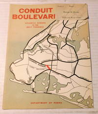
1941ref. 100047New York: Department of Parks City of New York June 16 1941. 1941. Very good. - Quarto 11 inches high by 8-3/8 inches wide. Softcover bound in stapled wraps titled in orange and illustrated with a black & white map on the front cover. The covers are slightly soiled. 8 unnumbered pages illustrated in color and black & white including color graphs and black & white aerial photographs by Fairchild Aerial Surveys Inc. Very good. A brochure describing the proposed expansion of Conduct Boulevard under the dynamic urban planner Robert Moses. Distributed "Courtesy of George U. Harvey President of the Borough of Queens" with a presentation paper slip stapled at the top of the front cover. Conceived in 1921 Conduit Boulevard is an arterial road in New York City. The large majority of Conduit Boulevard is in Queens. A divided highway it runs from Atlantic Avenue in Cypress Hills to Hook Creek Boulevard in Rosedale and was expanded in 1940 with the Belt Parkway. New York: Department of Parks, City of New York, June 16, 1941. paperback
2024ref. 2-03239560252024. Paperback. New. 464 pages. 9.00x6.00x9.00 inches. paperback
ref. 2494509793.Gpaperback. Good. Access codes and supplements are not guaranteed with used items. May be an ex-library book. paperback
ref. 3844335757.Gpaperback. Good. Access codes and supplements are not guaranteed with used items. May be an ex-library book. paperback
1909ref. 481511909. NEW YORK REGIMENTAL. YOUNG Moses G. ed. A Condensed History of the 143d Regiment New York Volunteer Infantry of the Civil War 1861-1865. Together with a Register or Roster of All the Members of the Regiment and the War Record of Each Member as Recorded in the Adjutant-General's Office at Albany N.Y. Newburgh NY 1909. 239pp. Portrait frontis. portraits. Orig. cloth. Front hinge a bit tender. Near fine. Dornbusch I-545. unknown