Greenleaf, MosesBiblio.com
10,874 results
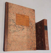
1829ref. 49267Portland: Shirley and Hyde 1829. First edition. The title page of Greenleaf's 1829 . Portland: Shirley and Hyde 1829. First edition. The title page of Greenleaf's 1829 "Survey" says it is "Illustrated by Maps." In fact these maps are in a separate atlas published without a title page. "Atlas Accompanying Greenleaf's Map and Statistical Survey of Maine." Contents as follows:1. Orthographic projection of the situation of the mountain and highland ranges particularly in the northern part of the State.2. 10 Vertical projections of the elevation of the northern and eastern boundary line with those of sections across the State from the Atlantic to the St. Lawrence; and the comparative declivities of the principal rivers.3. Sketch of the British map got up during the late war with a view to raise pretence for a claim to a new boundary.4. Maps of the British surveyors under the treaty of Ghent shewing their pretended ranges of highlands across the State. The 4 preceding Maps are designed to exhibit the true merits of the question of the disputed boundary as far as it is affected by the direction and elevation of the highlands.5. Map of the original grants and sales of land under which the titles are now holden -- from the earliest dates to the latest divisions of land between Maine and Massachusetts.6. Map exhibiting the progress present density and distribution of population and wealth; and the present representative districts.7. A comparative view of the climate of Maine and others of the United States and of England exhibited in a series of diagrams of the monthly means and extremes of temperature."Greenleaf was as in many of his endeavors ahead of his time in publishing an atlas devoted to an individual state. This atlas was preceded only by Robert Mill's 1825 Atlas of the State of South Carolina and David Burr's 1829 Atlas of the State of New York and it was not until many years later that another such state atlas appeared." - Ed Thompson "Important Maine Maps." "Atlas" and The book "Survey of the State of Maine" and its accompanying atlas brought $7475 and $546 respectively in Thompson's 2003 auction. The two items offered here are in superior condition to Thompson's copies. "Survey" is bound in contemporary half calf over marbled boards and has a black spine label with gold lettering. Minor rubbing to covers and foxing in text but a very good condition of a rare book. The atlas also bound in half calf over marbled boards has a printed paper cover label. The maps show some old repairs along folds but are in very good condition. Laid into the atlas is a two-sheet manuscript "Map of Township B. Surveyed by D. Parker Esq." Done in sepia ink and pencil. 40 x 32 cm. 21.5 cm. viii 468 pp. and 33.5 cm. Seven folding hand colored maps. . Shirley and Hyde hardcover
ref. 1018029222.Ghardcover. Good. Access codes and supplements are not guaranteed with used items. May be an ex-library book. hardcover
ref. 101803420X.Gpaperback. Good. Access codes and supplements are not guaranteed with used items. May be an ex-library book. paperback
ref. 1240909675.Gpaperback. Good. Access codes and supplements are not guaranteed with used items. May be an ex-library book. paperback
ref. 1178951375.Gpaperback. Good. Access codes and supplements are not guaranteed with used items. May be an ex-library book. paperback
ref. 0266414117.Ghardcover. Good. Access codes and supplements are not guaranteed with used items. May be an ex-library book. hardcover
1829ref. 49267Portland: Shirley and Hyde 1829. First edition. The title page of Greenleaf's 1829 . Portland: Shirley and Hyde 1829. First edition. The title page of Greenleaf's 1829 "Survey" says it is "Illustrated by Maps." In fact these maps are in a separate atlas published without a title page. "Atlas Accompanying Greenleaf's Map and Statistical Survey of Maine." Contents as follows:1. Orthographic projection of the situation of the mountain and highland ranges particularly in the northern part of the State.2. 10 Vertical projections of the elevation of the northern and eastern boundary line with those of sections across the State from the Atlantic to the St. Lawrence; and the comparative declivities of the principal rivers.3. Sketch of the British map got up during the late war with a view to raise pretence for a claim to a new boundary.4. Maps of the British surveyors under the treaty of Ghent shewing their pretended ranges of highlands across the State. The 4 preceding Maps are designed to exhibit the true merits of the question of the disputed boundary as far as it is affected by the direction and elevation of the highlands.5. Map of the original grants and sales of land under which the titles are now holden -- from the earliest dates to the latest divisions of land between Maine and Massachusetts.6. Map exhibiting the progress present density and distribution of population and wealth; and the present representative districts.7. A comparative view of the climate of Maine and others of the United States and of England exhibited in a series of diagrams of the monthly means and extremes of temperature."Greenleaf was as in many of his endeavors ahead of his time in publishing an atlas devoted to an individual state. This atlas was preceded only by Robert Mill's 1825 Atlas of the State of South Carolina and David Burr's 1829 Atlas of the State of New York and it was not until many years later that another such state atlas appeared." - Ed Thompson "Important Maine Maps." "Atlas" and The book "Survey of the State of Maine" and its accompanying atlas brought $7475 and $546 respectively in Thompson's 2003 auction. The two items offered here are in superior condition to Thompson's copies. "Survey" is bound in contemporary half calf over marbled boards and has a black spine label with gold lettering. Minor rubbing to covers and foxing in text but a very good condition of a rare book. The atlas also bound in half calf over marbled boards has a printed paper cover label. The maps show some old repairs along folds but are in very good condition. Laid into the atlas is a two-sheet manuscript "Map of Township B. Surveyed by D. Parker Esq." Done in sepia ink and pencil. 40 x 32 cm. 21.5 cm. viii 468 pp. and 33.5 cm. Seven folding hand colored maps. . Shirley and Hyde hardcover books
2018ref. Gyan-9789361250286Facsimile Publisher 2018. Hardcover. New. 22.59 x 14.34 x 3.55 cm. English Facsimile Publisher hardcover
2018ref. Gyan-9789361250286Facsimile Publisher 2018. Hardcover. New. 22.59 x 14.34 x 3.55 cm. English Facsimile Publisher hardcover
ref. 0428343961.Ghardcover. Good. Access codes and supplements are not guaranteed with used items. May be an ex-library book. hardcover
ref. 1333665253.Gpaperback. Good. Access codes and supplements are not guaranteed with used items. May be an ex-library book. paperback
ref. B9781425536824Paperback / softback. New. paperback
ref. 3337034047.Gpaperback. Good. Access codes and supplements are not guaranteed with used items. May be an ex-library book. paperback
ref. 0548637172.Gpaperback. Good. Access codes and supplements are not guaranteed with used items. May be an ex-library book. paperback
ref. 1163948683.Gpaperback. Good. Access codes and supplements are not guaranteed with used items. May be an ex-library book. paperback
ref. 1347247351.Ghardcover. Good. Access codes and supplements are not guaranteed with used items. May be an ex-library book. hardcover
2010ref. DADAX1163666661Kessinger Publishing 2010-09-10. hardcover. New. 6.00x0.69x9.00. Buy with confidence. Excellent Customer Service & Return policy. Kessinger Publishing hardcover
ref. 0548295166.Gpaperback. Good. Access codes and supplements are not guaranteed with used items. May be an ex-library book. paperback
ref. 1163666661.Ghardcover. Good. Access codes and supplements are not guaranteed with used items. May be an ex-library book. hardcover
ref. 1163603945.Gpaperback. Good. Access codes and supplements are not guaranteed with used items. May be an ex-library book. paperback
ref. 1356777473.Ghardcover. Good. Access codes and supplements are not guaranteed with used items. May be an ex-library book. hardcover
2017ref. 2-6202404892Novas Edições Acadêmicas 2017. Paperback. New. 56 pages. 8.66x5.91x0.13 inches. Novas Edições Acadêmicas paperback
ref. 1340582694.Ghardcover. Good. Access codes and supplements are not guaranteed with used items. May be an ex-library book. hardcover
ref. 6128877326VDM Verlag Dr. Mueller Aktiengesellschaft & Co. KG . Papeback. New. pp. 60 VDM Verlag Dr. Mueller Aktiengesellschaft & Co. KG unknown
2011ref. DADAX3844317384LAP Lambert Academic Publishing 2011-03-24. paperback. New. 5.91x0.14x8.66. Buy with confidence. Excellent Customer Service & Return policy. LAP Lambert Academic Publishing paperback


