Moreux, L'AbbeBiblio.com

Best.-Nr. 12514Paris: G. Doin & Co. . Very Good. Nouvelle edition. Hardcover. Tape to both endpapers; INSCRIBED by author to half-title page. DJ front bound in. No date ca. Late 30s. In French. Various newspaper clippings laid in; 12mo 7" - 7½" tall; 249 pages . N.D. G. Doin & Co. hardcover
1901Best.-Nr. 12329London: George Allen. Very Good. Hardcover. Bound into the book is a nicely written typed letter to the book's recipient. Folding map in front pocket; B&W Photographs; 16mo 6" - 7" tall; 94 pages . 1901. George Allen hardcover
1952Best.-Nr. 11448London: Compagnie Universelle Du Canal Maritime De Suez. Very Good. Softcover. Light wear to extremities and spine with slight staining to soft wraps; The history of the construction of the Canal with numerous photos and several charts and two fold-out maps. INSCRIBED on first page by Monsieur Dominique De Grieges to Edwin Sunderland; B&W Photographs; 4to 11" - 13" tall; 76xxv pages . 1952. Compagnie Universelle Du Canal Maritime De Suez paperback
1933Best.-Nr. 3730London: Macmillan. Very Good. Hardcover. Both volumes have light rubbing to extremities. Vol one has light foxing throughout and front hinge starting; Vol two has foxing to edges; Volume one has fold-out map of the region in rear. Intended as a follow-up to the Earl of Cromer's 'Modern Egypt ' Lloyd covers the fifty years since the British occupied Egypt to install a new government supposedly for their own good.; 8vo 8" - 9" tall; 390 418 pages . 1933. Macmillan hardcover
1905Best.-Nr. 3751Chicago: Fleming H. Revell. Very Good-. First Edition. Hardcover. Boards with light Rubbing to extremities. Binding gapping in a couple of places but holding together.; Gray boards with red lettering and a picture in silhouette of a rider on a camel; B&W Photographs; 8vo 8" - 9" tall; 399 pages . 1905. Fleming H. Revell hardcover
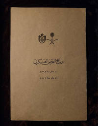
Best.-Nr. 8This official programme commemorates the historic state visit of King Abdulaziz Al Saud the founder of modern Saudi Arabia to Egypt in 1946. The visit marked an important milestone in strengthening political and diplomatic relations between the Kingdom of Saudi Arabia and Egypt following the Second World War. The programme outlines the official schedule of ceremonies receptions and meetings held during the royal visit. Such publications were produced in limited numbers for officials and invited guests making surviving copies increasingly scarce. Today they are valued as significant historical documents that reflect one of the most important royal visits in modern Arab history.
1890Best.-Nr. TK0363Probably ca. 1890s. i.e. certainly before 1905. 1890. Folio. 14 x 15.5 inches. 48 original mounted professional photographs each a full-page image. Modern half red morocco cloth. A piece of the original cloth cover with the title in German as shown is mounted within the volume. Fine. 48 fine vintage photographs 23 of which are signed by the photograph 19 by the Zangaki Brothers; 4 by Antoine Beoto. The images are taken in the southern Egyptian Luxor region including images of the Valley of the Kings at Luxor temple the Nile Karnak temple and Thebes. / The first photograph shows the Sphynx and in front are a couple presumedly a husband & wife perhaps German or Swiss-German obviously tourists. This is their memory album of a visit to Luxor in southern Egypt the place of the Valley of the Kings. The photographs some of which are titled are chiefly titled in French. Even though 23 of the photographs are signed it is clear that the whole album is made up of images from these two photographers meaning that 47 of the images should be either by the Zangaki Brothers or Antoine Beoto's studio. The only unique image should be the first one showing the two travelers and their guides. Probably ca. 1890s. [i.e., certainly before 1905]. hardcover
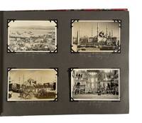
1927Best.-Nr. 208311927. Photo album documenting a multi country group यातà¥à¤°à¤¾ in 1927 records interwar travel across southern Europe and the eastern Mediterranean including regions under colonial administration and recent political transition. The album follows a group of travelers moving from France through Italy Greece Turkey British administered Palestine and Egypt capturing urban landmarks archaeological sites and local populations encountered along the route. The sequence provides visual evidence of tourism infrastructure mobility and cross cultural observation during a period when former imperial territories such as Constantinople were undergoing redefinition following the dissolution of the Ottoman Empire and the establishment of modern nation states. Album contains 93 black and white silver gelatin photographs and four real photo postcards with images ranging approximately from 2.5 x 4 inches to 3.5 x 5.5 inches and one larger group photograph measuring about 9 x 7 inches. Photographs are mounted on black paper boards with handwritten captions in white pencil and interleaved tissue guards; string bound in patterned cloth boards. The album opens in Avignon with views of St. Pierre's Church and the Palais des Papes then continues through Italy with scenes of Naples and Pompeii as well as shipboard images captioned S.S. Adriatic. Subsequent sections include Athens with views of the Parthenon followed by Constantinople where four postcards depict the harbor the Sultan Ahmed Mosque and the Hagia Sophia shortly after the end of the Ottoman Empire. In British Mandate Palestine images show street scenes in Nazareth and Jerusalem including sites along the River Jordan the Western Wall and the Garden of Gethsemane alongside a captioned portrait labeled "A Jewish Maiden." The album concludes in Egypt with extensive views of archaeological and urban sites at Thebes Memphis Cairo and Luxor including the Obelisk of Hatshepsut Edfu Temple the tomb of Amenhotep II the Colossi of Memnon and the pyramids and Great Sphinx at Giza where the final group portrait shows the travelers posed on camels. Produced during the interwar period the album reflects expanding international tourism networks alongside ongoing European influence in the eastern Mediterranean and Middle East. The juxtaposition of ancient sites modern transport and local populations situates the material within broader histories of archaeology empire and travel culture in the early twentieth century. Light general wear to album and mounts; images well preserved with clear captions; overall very good condition. unknown
1900Best.-Nr. 180921900. Archive of 9 stereoview photographs bearing a double 6" x 3" inch photograph showing various scenes from turn of the century Egypt. 1896-1900. Images include the Temple of Luxor village women carrying pitchers of water on their heads a caravan at the Tomb of the Khalif's the Virgin's tree and the Great Nile Bridge. Locations are marked beneath the images in text. 5 include identifying information in multiple language on verso. Most are marked "J.F.Jarvis Publisher Washington D.C" in cursive script with small black "x" mark in corner and "Sold only by Underwood & Underwood New York London Toronto Canada Ottawa Kansas." Images are clear and detailed. Most in very good condition. unknown
1885Best.-Nr. 139691885. Beato Antonio. Two photographs of a Ramesses statue and monumental Egyptian architecture circa 1880s document the archaeological landscape of Upper Egypt during the expansion of commercial photography and European travel along the Nile. The images preserve the scale surface condition and immediate surroundings of ancient remains as they appeared before many subsequent excavation conservation and tourism projects altered their presentation. Their attribution to Beato connects them to a photographer who maintained a long career in Luxor and produced albumen views of Egyptian monuments for an international market supporting research into the visual reception of ancient Egypt archaeological tourism nineteenth-century photographic commerce and the documentation of historic sites. Museum collections date comparable Beato photographs of Luxor and Egyptian monuments to the 1870s and later nineteenth century. Two albumen photographs circa 1880s each measuring approximately 8½ × 10 inches and mounted recto and verso on a single 10 × 10 inch board. One photograph shows a monumental statue identified as Ramesses and bears the ink signature "A. Beato" on the image. The second presents a large Egyptian monument from a different viewpoint and appears to carry the signature "A. Beato" within the negative. The absence of more specific captions prevents a secure identification of the second structure from the available description. The paired mounting brings together two examples of Beato's emphasis on isolated architectural remains and monumental scale using the albumen process to render carved stone structural mass and the surrounding archaeological terrain with clarity. Antonio Beato worked extensively in Egypt and became particularly associated with photographic views of Luxor Karnak and nearby ancient sites; surviving institutional holdings include his photographs of Luxor Temple Karnak and the Ramesseum. Earlier scholarship sometimes confused Antonio with his brother Felice because photographs circulated under overlapping forms of the Beato name but the Egyptian subjects and "A. Beato" signatures here support attribution to Antonio whose career centered on Egypt. The mount has cockling and a bent upper corner not affecting either image; both photographs have scattered surface scratches. Photographs good mount fair. The recto-and-verso presentation offers two complementary records of ancient Egyptian monuments as they were encountered and marketed through late nineteenth-century Nile photography. unknown
1896Best.-Nr. 144071896. Underwood & Underwood. Seven stereoviews of Egypt circa 1896 to 1904 record Egyptian people animals commerce Nile water gathering and ancient monuments within the American publisher's extensive photographic survey of the country. The group ranges from women drawing water from the Nile and a crowded market to the obelisk at Heliopolis and statues of Ramesses II pairing contemporary Egyptian life with the Pharaonic sites that figured prominently in Western photographic representations of Egypt. Underwood & Underwood's larger Egypt through the Stereoscope series comprised approximately 100 views produced principally between 1896 and 1904 intended to create a sequential three-dimensional photographic tour of the country. Seven original Underwood & Underwood stereoview photographs Egypt circa 1896 to 1904. Each card bears descriptive text on the verso. The subjects comprise: 1 the obelisk at Heliopolis; 2 a group of Egyptian women drawing water from the Nile; 3 an Egyptian drummer mounted on a camel with palm trees behind him; 4 a mother camel and recently born calf with the pyramids of Giza visible in the background; 5 villagers seated outside a tent captioned by the publisher "Wretchedness of the People"; 6 a large crowd gathered at a local market; and 7 statues of Ramesses II surrounded by palm trees. The views move between archaeological monuments and scenes of work transportation trade domestic life and the Nile while the stereoscopic format was designed to give viewers an illusion of spatial depth when seen through a stereoscope. Underwood & Underwood marketed stereoscopic tours as a means for audiences abroad to encounter distant countries through paired photographs and accompanying explanatory text. Institutional holdings confirm that its Egypt through the Stereoscope photographs date principally from 1896 to 1904 and encompass monuments landscapes city views people and animals. The publisher's caption "Wretchedness of the People" is particularly revealing as historical evidence of the interpretive framework imposed upon Egyptian subjects for Western consumers: rather than a neutral identification of the people pictured the wording directs the viewer toward a judgment about their material circumstances. The seven cards therefore preserve both photographic evidence of Egypt around the turn of the twentieth century and the captions through which Underwood & Underwood presented the country to its international audience. Each photograph retains descriptive text on the verso; all are in very good condition. unknown
1885Best.-Nr. 140491885. Zangaki Adelphoi. Interior of the hypostyle hall at the Temple of Hathor at Dendera circa 1880s records one of Upper Egypt's major surviving temple interiors during the period when commercial photographers produced extensive visual records of Egyptian antiquities for an international audience. The Zangaki studio active in Egypt during the later nineteenth century specialized in views of archaeological sites cities landscapes and life along the Nile. This image preserves the appearance of Dendera's monumental columned interior during the same decade in which British occupation of Egypt began in 1882 and European archaeological and photographic activity in the country continued to expand. Albumen photograph circa 1880s measuring 11 x 8 inches. The view looks through the hypostyle hall of the Temple of Hathor where massive columns rise to capitals carved with the face of Hathor. Sunlight striking the columns and upper masonry emphasizes their scale while the central perspective terminates in a small doorway opening onto a darker interior containing visible rubble. The contrast between the monumental columns and the human scale of the distant doorway gives the photograph a particularly clear record of the hall's architecture and spatial arrangement. Dendera was among the Egyptian sites repeatedly photographed by commercial studios during the nineteenth century when photographs of temples and ancient monuments circulated through the developing European and American market for archaeological and travel imagery. The period also coincided with increasing European political and financial intervention in Egypt and after 1882 British military occupation; these developments formed part of the larger colonial setting in which antiquities excavated objects and photographic records circulated abroad. Small tear near the top margin; otherwise exceptionally well preserved with the architectural details and tonal contrasts remaining clear. Overall near fine condition. unknown
1973Best.-Nr. 89599Le Caire: Organisme General des Imprimies Gouvernmentales 1973. Paperback. Very Good. photos maps and plans some folding 190p. Softcover in original wrapper. 25cm. Wrapper splitting at bottom of front fold. Articles in French English or German. Organisme General des Imprimies Gouvernmentales paperback
1988Best.-Nr. 89734Le Caire: Organisme Genereal des Imprimeries Gouvernmentales 1988. Paperback. Very Good. photos illustrations and diagrams 3 folding 224p. Softcover in original wrapper. 24cm. Bookplate American Jounal of Archaeology. French text. Organisme Genereal des Imprimeries Gouvernmentales paperback
1987Best.-Nr. 89713Le Caire: Organisme General des Imprimeries Gouvernementales 1987. Paperback. Very Good. photos maps some folding 266p. Softcover in original wrapper. 24cm. French text. Organisme General des Imprimeries Gouvernementales paperback
1983Best.-Nr. 89878Le Caire: Le Service 1983. Paperback. Very Good. photos illustrations 383p. Softcover in original wrapper. 28cm. Upper right corner of last several pages bent. Articles in French English German or Italian. Le Service paperback
1985Best.-Nr. 89819Le Caire: Le Service 1985. Paperback. Very Good. phtots illustrations maps x 448 21p. Softcover in original wrapper. 28cm. Individual Articles documents studies etc. in French English or German. At head of title: Publicationa de l'Organisation des Antiquities Egyptiennes. Le Service paperback
1959Best.-Nr. 89883Le Caire: Service Antiquities de l'Egypte 1959. Paperback. Very Good. photos illustrations irregular pagination. Softcover in original wrapper. 28cm. French text. Minor cover soil. Tear reglued at bottom of backstrip. Service Antiquities de l'Egypte paperback
1987Best.-Nr. 89879Le Caire: Le Service 1987. Paperback. Very Good. photos illustrations xiv 264p. Softcover in original wrapper. 28cm. French text. Le Service paperback
1912Best.-Nr. 90121Le Caire: Imprimerie Nationale 1912. Paperback. Fair. xliv 342p. Softcover lacking almost all of original wrapper. 29cm. Minor chipping. Unopened. French text. Seven more volumes were issued over the next several years bringing the history up to 1916. Imprimerie Nationale paperback
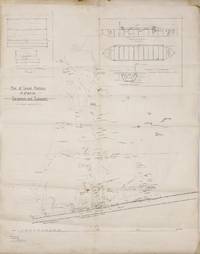
Best.-Nr. 114959A detailed map of the battleground of the failed attempt by Turkish troops to invade Egypt on 3 February 1915. At the head of the map are large sketches of 'Frame of Kerosene Tin Raft in Turkish Attack' and 'Sketch of Turkish Pontoons captured at Toussoum-Serapeum 4.2.1915'. The Australian War Memorial has one of the 24 pontoons used by the 4th Turkish Army in their attempt to cross the Suez Canal in its collection. In fact the AWM records that 'The action in which it was captured was the first in which a unit of the AIF 3 Field Company Australian Engineers was engaged and as such this trophy was the first captured by the army in the First World War. by May 1918 the Australian War Records Section was lobbying for an example to be brought back to Australia noting that while Australian involvement by 3 Field Company Engineers was small it was important'. Both Charles Bean 'The Official History of Australia in the War of 1914-18' Volume 1 Chapter VIII: 'The Turkish Expedition against Egypt' pages 140-165 and the AWM have much to say on this attack. After Turkey entered the war on 31 October 1914 one of the first objectives of both the Germans and Turks was to strike a blow against Britain in Egypt. By January 1915 a 'Turkish force of an estimated 10000 had travelled from Jerusalem to Kantara on the Suez Canal a distance of 200 miles. The force was composed of 5 percent Germans 10 percent Turks and 85 percent Bedouins and was aimed at raising anti-British feeling within the protectorate of Egypt inciting a Jihad and denying use of the canal to Allied forces. This potential threat forced the British to base up to 70000 troops in Egypt 30000 of them defending the Canal. Initially the Turks had three options: to attack from the Jordan-Mediterranean coast to Kantara through the Sinai from Beersheeba to Ismalia or from the south to Suez. Thus the British were obliged to keep options open defending all three zones along the 159 km of canal until it became obvious the Turks were marching south-west from Beersheeba heading for the central zone at Ismalia straight across the Sinai Desert. Despite being initially unconvinced that the Turks could actually organise such a crossing the British were aware of the intent; they decided to base their forces on the West Bank of the Suez using the canal as part of the defence bolstered by Royal Navy ships. This essentially meant giving up the Sinai. The force opposing the Turks mainly comprised of the 10th and 11th Divisions Indian Army. The New Zealand Wellington and Otago Battalions however assisted in the defence. The 3rd Field Company Engineers AIF were detached to operate searchlights and the Ismalia powerhouse but no other Australians were involved directly in the defence. The majority of defenders were hidden by high spoil banks thrown up on the west bank during construction of the Suez Canal. Small parties of Turks were spotted by a French seaplane on 15 January - but they missed most of the force heading out of Beersheeba and across the Sinai. This move was unexpected as most armies had moved along the coast. The Turks sent smaller parties to the southern & northern routes as a diversion and to keep the British guessing. The central party physically dragged their pontoons on wagons and artillery across the desert. Early on the morning of 3 February about 3:30 am movements and sounds were noticed by the defenders on the eastern bank and the Indian sentries started shooting. After dying down more sounds were noted a kilometre south. A Turkish pontoon landed on the west bank loaded with 25 Turks. This was charged by Punjabis and all the occupants were killed; a second crossed under fire but landed with only 10 survivors - four were captured in the morning. Pontoons were raked with shrapnel and machine gun fire killing all aboard. Many more were targeted on the east bank as their crews attempted to launch them with heavy casualties. Witnesses noted ten or eleven damaged pontoons drifting full of dead. Survivors tried to hide behind pontoons and make a dash for safety - many of these killed as well. Orders were given for Torpedo Boat 43 to blow up remaining intact pontoons. At the same time unaware of the disaster and hearing that some pontoons had already crossed the Turkish commander sent up thousands of reinforcements. The British Territorial artillery spotted them and started shooting as did the guns of the French battleship "Requin". An Indian counter-attack across the Canal took 250 prisoners and the attack ceased. The British had lost just on 160 men - the Turkish toll was ten times higher. The Turks retreated back across the desert. The Turkish performance at the Canal may have coloured Australian British and Indian attitudes to Turkish fighting ability which they brought to Gallipoli to their cost' AWM. Bean provides more and pertinent details: 'Early in January the 3rd Field Company of Australian Engineers . had been sent down to construct trenches and floating bridges at the Canal. The British authorities at once began to discover in this company men experienced in almost any work which was needed. Within a week some were detached to manipulate searchlights others had taken over the power-house at Ismailia sic others were surveying for artillery ranges or for maps while the main body was making bridgeheads at Serapeum Ismailia and Kantara and also a floating bridge for Ismailia ferry-post'. Bean's last words are also telling: 'There was a heavy fall in the current estimate of the fighting value of the Turkish Army. This was not without its influence on future events'. Those events which commenced on 25 April 1915 and reverberate to this day may go a long way to explaining why this extraordinary map appears to have been unrecorded. Bean was certainly unaware of it when he wrote his history; the AWM makes no reference to it; and Trove locates no examples. In the overall history of the First World War it may be a sideshow completely overshadowed by the Allied invasion of Turkey at Gallipoli: everything went according to the script of this dress rehearsal except the roles were reversed. unknown
1886Best.-Nr. 83474Le Caire 1886. Hardcover. Very Good. First item: 114p. Second item: 166p. Later quarter cloth with both wrappers bound in. 24 cm. Former owner's name. French text. hardcover
1883Best.-Nr. 83522Le Caire: Barbier 1883. Hardcover. Good. 566p. Contemporary quarterbinding. 17 cm. Moderate cover scuffing and wear. Inked note in French on endpaper. Hinges repaired. French text. Barbier hardcover
Best.-Nr. PD80Oblong Folio ca. 38 x 27 cm or 15 x 10 ½ in. 88 stiff paper leaves one blank. 87 mounted gelatin silver photographs ca. 22 x 17 cm 8 ½ x 6 ½ in. All but three images with period ink or pencil French captions on mounts. Period olive quarter morocco album with green pebbled cloth boards and spine with raised bands. Mounts slightly age-toned with minor tearing and creases on extremities not affecting photos; a few photos mildly faded but overall a very good album of interesting photos. An interesting and extensive collection of 87 large amateur gelatin silver photographs of Egypt before World War I. The album was likely compiled by French travellers on their journey up the Nile River in the early 1910s. Over 15 photographs show views from along the Nile. They include the compiler’s boats their dahabeah a river boat for use on the Nile and a small boat with two sails the First Cataract of the Nile the island of Elephantine near Aswan the river steamer Ibis villages along the Nile including a “Marabout” village and El Balyana a cable ferry a load of goglets crossing the river peasants standing on the banks women collecting water and irrigation devices. Over 20 photographs show ancient sites in Egypt including the Philae temple complex Medinet-Abou the Dendera temple complex Karnak Luxor Temple the Temple of Edfu Abydos and Esna. One photograph shows the interior of the tomb of Rameses V. Two photographs show a group of Arab women in front of a temple. Several photographs are views of Cairo including the Mosque-Madrasa of Sultan Hasan the Cairo Citadel the Mosque of Ibn Tulun the funerary complex of Sultan Qaytbay and the French Legation building. Other photographs show the Abu Haggag Mosque in Luxor built on top of ancient ruins and a quarry near Aswan. Other photographs are snapshots of daily life in Egypt. They include street scenes a Mawlid celebration “Fete des prophets” a demonstration in the streets a market in Aswan a public square in Esna a group of men sitting on the side of the road to the Pyramids of Giza a group of “fellahs” Egyptian peasants “au passage du bateau postal” and cane harvesting. Overall a very interesting collection of photographs of Egypt in the early 1910s. hardcover
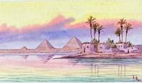
Best.-Nr. MC45Watercolour on paper ca. 6x11 cm 4 ¼ x 2 ½ in. Initialed ‘A.B.’ in the lower right corner. Period ink inscription on verso “With love and all good wishes for happier times in the near future. From Peggie”. Recently matted very good watercolour. Nice watercolour view of the Great Pyramids of Giza taken at sunset with the waters of Nile in the foreground reflecting the tender colours of the evening sky. unknown