Savorgnan de Brazza, PierreLivre Rare Book
3138 resultados
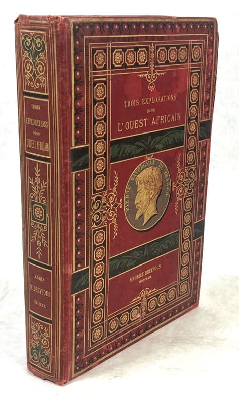
1887ref. 140774Paris, Maurice Dreyfous 1887 In-4 26 x 17 cm. Cartonnage éditeur percaline rouge, dos et plats ornés, tranches dorées, illustré de 2 eaux-fortes et de 80 dessins dans et hors-texte, exécutés d’apès nature ou d’après les documents authentiques, 463 pp., notes, table des matières, table des gravures.
ref. DADAX1571819452New unknown
2008Audio CD New Release item. Pls. allow a minimum of 4 - 6 weeks as this is hi p from CD Manufacturers.
1899ref. 91742London: Her Majesty's Stationery Office 1899. Presumed First Edition First Printing. Wraps. Good. 9 1 pages and 36 pages. Tabular Data. This item has been disbound from a larger volume and now has a stiff blue cover protecting it. The British Central Africa Protectorate BCA was a British protectorate proclaimed in 1889 and ratified in 1891 that occupied the same area as present-day Malawi: it was renamed Nyasaland in 1907. British interest in the area arose from visits made by David Livingstone from 1858 onward during his exploration of the Zambezi area. This encouraged missionary activity that started in the 1860s undertaken by the Universities' Mission to Central Africa the Church of Scotland and the Free Church of Scotland and which was followed by a small number of settlers. The Portuguese government attempted to claim much of the area in which the missionaries and settlers operated but this was disputed by the British government. To forestall a Portuguese expedition claiming effective occupation a protectorate was proclaimed first over the south of this area then over the whole of it in 1889. After negotiations with the Portuguese and German governments on its boundaries the protectorate was formally ratified by the British government in May 1891. As late as 1888 the British Foreign Office declined to accept responsibility for protecting the rudimentary British settlements in the Shire Highlands despite unsubstantiated claims by the African Lakes Company of Portuguese interference with their trading activities. However it also declined to negotiate with the Portuguese government on their claim that the Shire Highlands should be considered part of Portuguese East Africa as it was not regarded by the Foreign Office as under effective Portuguese occupation. In order to prevent Portuguese occupation the British government sent Henry Hamilton Johnston as British consul to Mozambique and the Interior with instructions to report on the extent of Portuguese rule in the Zambezi and Shire valleys and the vicinity and to make conditional treaties with local rulers beyond Portuguese jurisdiction. These conditional treaties of friendship did not amount to the establishment of a British protectorate but prevented those rulers from accepting protection from another state. In response to a Portuguese incursion Johnston's deputy John Buchanan declared a Shire Highlands Protectorate in Johnston's absence despite the contrary Foreign Office instructions. It seems probable that Buchanan's action made without reference to the Foreign Office but following instructions that Johnston had left was to prevent any further advance by the Portuguese rather than to establish British rule in the area. Johnston's proclamation of a further protectorate the Nyasaland Districts Protectorate west of Lake Malawi was also contrary to Foreign Office instructions. However it was endorsed by the Foreign Office in May 1891. This was because the discovery of the Chinde channel in the Zambezi delta which was deep enough to allow sea-going ships to enter the Zambezi which was an international waterway without having to enter Portuguese territory whereas previously such ships had to use the port of Quelimane. There followed an Anglo-Portuguese Crisis in which a British refusal of arbitration was followed by the 1890 British Ultimatum of 11 January 1890. This demanded that the Portuguese give up all claims to territories beyond the Ruo River and west of Lake Malawi. The Portuguese government accepted under duress and ordered their troops in the Shire valley to withdraw to the south bank of the Ruo. This order was received by the commander at Katunga on 8 March 1890 and all Portuguese forces had evacuated Katunga and Chiromo by 12 March. An 1891 Anglo-Portuguese treaty fixed the southern borders of what had been renamed the British Central Africa Protectorate. The treaty also granted Britain a 99-year lease over Chinde a port at one of the Zambezi delta mouths where sea-going ships could transfer goods and passengers to river boats. The northern border of the protectorate was agreed at the Songwe River as part of the Anglo-German Convention in 1890. Its western border with Northern Rhodesia was fixed in 1891 at the drainage divide between Lake Malawi and the Luangwa River by agreement with the British South Africa Company which governed what is today Zambia under Royal Charter until 1924. After this until 1898 troops were used to assist the locally recruited police force to suppress the slave trade. The three main groups resisting British occupation were Yao chiefs in the south of the protectorate and Swahili groups around the center and north of Lake Nyasa both involved in the slave trade and Ngoni people who had formed two aggressively expansionists kingdoms in the west and north. As the northern Ngoni kingdom did not threaten European trading interests as it was far from European-owned estates and as the Scottish mission at Livingstonia was influential within the kingdom Johnston did not use force against it. It accepted British rule in 1904 on condition of retaining its own traditions. Its king was recognized as a paramount chief the only one in the protectorate at that time. Her Majesty's Stationery Office paperback
ref. 13981348Bruxelles: Editions van Asshe, 1939 in-12, 664 pages, ills., 2 cartes se dépliant. Broché, couv. illustrée d'un beau dessin en couleurs de James Thiriar, très bel exemplaire, intérieur très frais, marque-pages publicitaires conservés.
ref. 13982905Lubumbashi: Société d'Edition, 1969 in-8, non paginé. Broché, couv. avec marques de maniement, autrement très bon état intérieur. Contient des publicités. Rare document.
ref. 13981900Paris: Imprimerie Nationale, 1906 tiré à part in-8, 60 pages, 5 cartes hors texte. Broché, couv. défr., autrement bon état. Envoi sur la couverture (nom effacé).
ref. 13973926Tervuren (Belgique): Musée Royal de l'Afrique Centrale, 1981 in-8, 164 pages, 5 planches en couleurs, 59 planches n/b, carte. Bibliographie. Broché, très bon état. ** 8°. 164 pp., 5 color plates, 59 b/w plates, map. Bibliography. Wpps., very fine copy.
ref. 13976123Berkeley, Los Angeles, London: University of California Press, 1985 in-8, xiv-313 p., frontispice, 100 ills. Bibliographie, index. Rel. toile, jaquette, bon état.
ref. 13977301Bruxelles; Gent: KBC; Snoeck-Ducaju & Zoon, 2002 in-4, 240 pages, 28 + 179 illustrations, carte. Bibliographie. Broché, très bon état.
ref. 13979802Stanleyville: Imprimerie moderne N. Colinvaux, 1955 in-8, 188 pages + nombreuses pages de couleurs n.c. Broché couv. illustrée par R. Carlier, petites défauts. Numéroté 474/2000, publicités de toutes les firmes au Congo.
ref. 13977730Tervuren: Musée Royal de l'Afrique centrale, 1962 2 vol. in-4, 231 pages, 3 cartes, 21 illustrations, 62 figures & 48 planches avec 462 illustrations. Broché.
ref. 199464Paris, Flammarion, s.d. (1898) in-8, 437 pp., frontispice, nbses ill. in-t., demi-basane brune, dos lisse orné de filets dorés (reliure de l'époque). Dos frotté, épidermures, coupes et coins usés. Rousseurs. Cachet (annulé).
1719Veduta, antica ed originale, inserita nel VI Tomo ”Atlas Historique ou nouvelle introduction a l’Histoire, à la Chronologie & à la Geographie Ancienne & Moderne…”, pubblicato ad Amsterdam nel 1719. Atlante che, con la sua pubblicazione, coniuga le mappe geografiche con incisioni e informazioni di carattere geografico, araldico, etnografico e storico così rendendo l’opera in sette volumi molto innovativa. Incisione in rame 365x430 mm.Henri Abraham Chatelain (1684 - 1743), pastore ugonotto originario di Parigi visse alternativamente a Parigi, Londra, L'Aia ed Amsterdam. Conosciuto come cartografo olandese per il sua opera cartografica monumentale in sette volumi “Atlas Historique” pubblicata ad Amsterdam con i suoi fratelli. Veduta panoramica della mitologica città di Lovango, con dieci vignette del popolo e cerimonie del Regno del Congo. Include il testo descrittivo
ref. 4206Bruxelles, Editions L. Cuypers, 1947. 22,5 x 14 cm, 392 pp. Relié demi-basane chocolat à coins, dos à nerfs orné, titre doré, tête dorée, papier de couvrure imitation peau de serpent (reliure signée Mossly). Bon exemplaire. Édition originale, un des 150 exemplaires numérotés sur Featherweight. Nombreuses illustrations photographiques.
ref. 4206Bruxelles, Editions L. Cuypers, 1947. 22,5 x 14 cm, 392 pp. Relié demi-basane chocolat à coins, dos à nerfs orné, titre doré, tête dorée, papier de couvrure imitation peau de serpent (reliure signée Mossly). Bon exemplaire. Édition originale, un des 150 exemplaires numérotés sur Featherweight. Nombreuses illustrations photographiques.
1972ref. C71379Brussel, Arcade 1972 367pp., met 180 illustraties (waarvan vele ingekleefde illustraties in kleur), 30cm., linnen band met stofwikkel, in linnen etui, mooie staat, standaardwerk, [text in dutch], gewicht: 3.9 kg., C71379
ref. 13982066Bruxelles: Bernard de Grunne, 2022 in-4, 151 pages, 15 figures dans le texte, 70 illustrations hors texte en couleurs. Broché, comme neuf. Texte français et anglais.
ref. 13982683Bruxelles: Bernard de Grunne Tribal Fine Arts, 2013 in-4, 64 pages, 23 illustrations. Broché, couv. illustrée à rabats, très bon état.
ref. 13981849Bruxelles: Editions R. De Rouck, 1938 in-folio, 4 p. n.c., 12 planches à double page en couleurs, 13 pages (index). Cartonnage d'éd., dos et coins tollés, état d'usage.
1893114pp.illustré de tabelles + 4 planches hors-texte, 29cm., br.orig. (dos renforcé), pour la plupart non coupé, extrait du tome LIII des "Mémoires couronnés et Mémoires des savants étrangers publiés par l'Académie royale des sciences, des lettres et des beaux-arts de Belgique" (1893), rare, C89637
1893ref. C89637Bruxelles, Hayez 1893 114pp.illustré de tabelles + 4 planches hors-texte, 29cm., br.orig. (dos renforcé), pour la plupart non coupé, extrait du tome LIII des "Mémoires couronnés et Mémoires des savants étrangers publiés par l'Académie royale des sciences, des lettres et des beaux-arts de Belgique" (1893), rare, C89637
1931ref. 17570Paris Imprimerie Nationale 1931 Fort In-4° 516 pp et de nombreuses cartes et plans dépliants, imprimé sur beau papier vergé Montgolfier . la couverture à été arrachée, brochage à relier où à restaurer. publication dans le cadre de l'Expositrion coloniale 1931.
ref. 9077Paris, C. Reinwald, 1900. 25,5 x 17 cm, viii-724 pp., in fine 5 cartes dépliantes, une très grande planche dépliante "Panorama de la rive gauche du Congo", et 5 planches. Reliure cartonnage d'éditeur pleine percaline, exemplaire en parfait état.
ref. 9077Paris, C. Reinwald, 1900. 25,5 x 17 cm, viii-724 pp., in fine 5 cartes dépliantes, une très grande planche dépliante "Panorama de la rive gauche du Congo", et 5 planches. Reliure cartonnage d'éditeur pleine percaline, exemplaire en parfait état.


