2026ref. x-1009711652Cambridge University Press 2026. Hardcover. New. 2nd revised edition edition. 884 pages. 8.00x1.88x10.00 inches. Cambridge University Press hardcover
ref. 48320087-nnew. unknown
ref. 62117548Taylor & Francis Group . Hardback. New. pp. 432 Taylor & Francis Group hardcover
ref. 51280-nnew. unknown
ref. SONG0128104236Academic Press 2017-02-10. 2. paperback. Used: Good. 7.50x1.24x9.25. Buy with confidence. Excellent Customer Service & Return policy. Academic Press paperback
ref. 35836323-nnew. unknown
ref. 3494353-nnew. unknown
2014ref. x-1446285804Sage Pubns Ltd 2014. Hardcover. New. 154 pages. 9.75x7.00x0.50 inches. Sage Pubns Ltd hardcover
1998ref. DBS-9780817639662Birk 1998. 1st. Hardcover. New. Birk hardcover
1998ref. DBS-9780817639662Birk 1998. 1st. Hardcover. New. Birk hardcover
ref. ria9780471627456_inpHardback. New. New Book; Fast Shipping from UK; Not signed; Not First Edition; Aimed at the senior level undergraduate and graduate computer science student this book provides an introduction to the field of data communications. Assuming no prior knowledge of the field it explains of the role of communications hardcover
ref. 85012Rome GA: 1908. Typed letter signed. 1pp on Maddox's law office stationery; Sept. 6 1908; seeking appointment to the Commission for the Chickamauga and Chattanooga National Park. 27 lines ca 220 words; signed in full. With "Received" stamp of the Office of the Secretary of War dated Sep 14 1908; docketed on verso in Joseph G. Cannon's hand with a ca. 100-word endorsement of Maddox's application. Old folds; lightly browned; Very Good. Maddox a Confederate veteran and five-term Congressional Representative for Georgia 1893-1905 writes seeking appointment to the Commission in charge of the Chickamauga and Chattanooga National Military Park which as part of its charter required that at least one Confederate veteran be a member: ".As you know I was a Confederate soldier; and I was in the battle of Chickamauga before I was sixteen years old. The Chickamauga Battlefield is in my old Judicial Circuit when I was Judge of the Superior Court and it is in the District which I represented in Congress for twelve years.I would certainly take great pride as I always have done heretofore in the protection and care of this great National Park and I feel that if you would be kind enough to write or tell the President who I am and what you know of me as a Representative in Congress it would go a long way in securing the appointment." On verso is Cannon's holograph statement addressed to "the President" supplying the requested recommendation: ".John W. Maddox was for several terms a Democratic member of Congress from Georgia. He was one of the most efficient members of the minority & while a good partisan had the ability & courage to distinguish between partisanship & legislature.if I had the authority I would appoint Mr. Maddox" signed "JG Cannon" dated 9/11 1908. unknown
ref. 85012Rome GA: 1908. Typed letter signed. 1pp on Maddox's law office stationery; Sept. 6 1908; seeking appointment to the Commission for the Chickamauga and Chattanooga National Park. 27 lines ca 220 words; signed in full. With "Received" stamp of the Office of the Secretary of War dated Sep 14 1908; docketed on verso in Joseph G. Cannon's hand with a ca. 100-word endorsement of Maddox's application. Old folds; lightly browned; Very Good. Maddox a Confederate veteran and five-term Congressional Representative for Georgia 1893-1905 writes seeking appointment to the Commission in charge of the Chickamauga and Chattanooga National Military Park which as part of its charter required that at least one Confederate veteran be a member: ".As you know I was a Confederate soldier; and I was in the battle of Chickamauga before I was sixteen years old. The Chickamauga Battlefield is in my old Judicial Circuit when I was Judge of the Superior Court and it is in the District which I represented in Congress for twelve years.I would certainly take great pride as I always have done heretofore in the protection and care of this great National Park and I feel that if you would be kind enough to write or tell the President who I am and what you know of me as a Representative in Congress it would go a long way in securing the appointment." On verso is Cannon's holograph statement addressed to "the President" supplying the requested recommendation: ".John W. Maddox was for several terms a Democratic member of Congress from Georgia. He was one of the most efficient members of the minority & while a good partisan had the ability & courage to distinguish between partisanship & legislature.if I had the authority I would appoint Mr. Maddox" signed "JG Cannon" dated 9/11 1908. unknown books
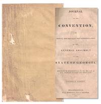
1839ref. 72330Milledgeville: P.L. Robinson 1839. Paperback. Good. Paperback. First Edition. 74pp. Bound in contemporary plain wraps with some loss to the edges and top corner of the last few pages. Front wrap title page and some signatures loose but present. A good complete example. Day-by-day account of the proceedings showing lists of delegates their counties and how they voted on each issue. Derenne Volume Two page 466. P.L. Robinson paperback
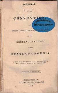
1839ref. 72801Milledgeville: P. L. Robinson State Printer 1839. Paperback. Good. Paperback. First Edition. 74pp. Former institutional copy with blind embossed seal and blue oval stamp top on the title page. Institution stamp name marked in black pen. Title page slightly loose else a good complete example. P. L. Robinson, State Printer paperback
1839ref. 72330Milledgeville: P.L. Robinson 1839. Paperback. Good. Paperback. First Edition. 74pp. Bound in contemporary plain wraps with some loss to the edges and top corner of the last few pages. Front wrap title page and some signatures loose but present. A good complete example. Day-by-day account of the proceedings showing lists of delegates their counties and how they voted on each issue. Derenne Volume Two page 466. P.L. Robinson paperback books
1839ref. 72801Milledgeville: P. L. Robinson State Printer 1839. Paperback. Good. Paperback. First Edition. 74pp. Former institutional copy with blind embossed seal and blue oval stamp top on the title page. Institution stamp name marked in black pen. Title page slightly loose else a good complete example. P. L. Robinson, State Printer paperback books
1920ref. 41205Washington D.C.: Published by the United States Coast and Geodetic Survey 1920. Large folding nautical chart printed on heavy paper stock. Colored. A rare original coastal survey of Ossabaw Sound including Ossabaw Island Skidaway Island Wassaw National Wildlife Rescue and the Vernon and Ogeechee Rivers. Established by President Thomas Jefferson in 1807 as the Survey of the Coast the U.S. Coast and Geodetic Survey was the United States' first civilian scientific agency. This agency has followed its mission to survey the U.S. coastline create nautical charts of the coast and help increase maritime safety since its founding and has often played fascinating roles in significant chapters of U.S. history. It served in all theaters of the Civil War in the service of the Union Army and Navy pioneered acoustic exploration in the wake of the sinking of the Titanic and during WWI it worked to detect enemy submarines. In addition this agency worked to survey and produce detailed maps and renderings of the U.S. coast. These nautical survey maps commonly referred to as "T-sheets" provide fascinating insights into the history of the United States coastline which has and will continue to shift. These maps are the most important data source for understanding the physical and ecological characteristics of the U.S. shoreline. The present map is a highly detailed and accurate sea chart of the Ossabaw Sound and an important historical view of the developing Georgia. Published by the United States Coast and Geodetic Survey unknown
1920ref. 41205Washington D.C.: Published by the United States Coast and Geodetic Survey 1920. Large folding nautical chart printed on heavy paper stock. Colored. A rare original coastal survey of Ossabaw Sound including Ossabaw Island Skidaway Island Wassaw National Wildlife Rescue and the Vernon and Ogeechee Rivers. Established by President Thomas Jefferson in 1807 as the Survey of the Coast the U.S. Coast and Geodetic Survey was the United States' first civilian scientific agency. This agency has followed its mission to survey the U.S. coastline create nautical charts of the coast and help increase maritime safety since its founding and has often played fascinating roles in significant chapters of U.S. history. It served in all theaters of the Civil War in the service of the Union Army and Navy pioneered acoustic exploration in the wake of the sinking of the Titanic and during WWI it worked to detect enemy submarines. In addition this agency worked to survey and produce detailed maps and renderings of the U.S. coast. These nautical survey maps commonly referred to as "T-sheets" provide fascinating insights into the history of the United States coastline which has and will continue to shift. These maps are the most important data source for understanding the physical and ecological characteristics of the U.S. shoreline. The present map is a highly detailed and accurate sea chart of the Ossabaw Sound and an important historical view of the developing Georgia. Published by the United States Coast and Geodetic Survey unknown books
1920ref. 41202Washington D.C.: Published by the United States Coast and Geodetic Survey 1920. Large folding nautical chart printed on heavy paper stock. Uncolored. A rare original coastal survey of the St Catherines Sound and includes St. Catherines Island and Ossabaw Island. Established by President Thomas Jefferson in 1807 as the Survey of the Coast the U.S. Coast and Geodetic Survey was the United States' first civilian scientific agency. This agency has followed its mission to survey the U.S. coastline create nautical charts of the coast and help increase maritime safety since its founding and has often played fascinating roles in significant chapters of U.S. history. It served in all theaters of the Civil War in the service of the Union Army and Navy pioneered acoustic exploration in the wake of the sinking of the Titanic and during WWI it worked to detect enemy submarines. In addition this agency worked to survey and produce detailed maps and renderings of the U.S. coast. These nautical survey maps commonly referred to as "T-sheets" provide fascinating insights into the history of the United States coastline which has and will continue to shift. These maps are the most important data source for understanding the physical and ecological characteristics of the U.S. shoreline. The present map is notable for its inclusion of St. Catherines Island the northernmost outpost in Spanish Florida between 1587 and 1680 with Catholic friars and Spanish soldiers living among the Guale Indians for over a century there. After the Spanish abandoned the island Mary Musgrove a Muskogee leader and translator for James Ogelthorpe claimed the island. Later Button Gwinnett a signer of Declaration of Independence also called this island home. This map is a highly detailed and accurate sea chart of St. Catherines Sound and an important historical view of the developing coastal Georgia. Published by the United States Coast and Geodetic Survey unknown
1920ref. 41202Washington D.C.: Published by the United States Coast and Geodetic Survey 1920. Large folding nautical chart printed on heavy paper stock. Uncolored. A rare original coastal survey of the St Catherines Sound and includes St. Catherines Island and Ossabaw Island. Established by President Thomas Jefferson in 1807 as the Survey of the Coast the U.S. Coast and Geodetic Survey was the United States' first civilian scientific agency. This agency has followed its mission to survey the U.S. coastline create nautical charts of the coast and help increase maritime safety since its founding and has often played fascinating roles in significant chapters of U.S. history. It served in all theaters of the Civil War in the service of the Union Army and Navy pioneered acoustic exploration in the wake of the sinking of the Titanic and during WWI it worked to detect enemy submarines. In addition this agency worked to survey and produce detailed maps and renderings of the U.S. coast. These nautical survey maps commonly referred to as "T-sheets" provide fascinating insights into the history of the United States coastline which has and will continue to shift. These maps are the most important data source for understanding the physical and ecological characteristics of the U.S. shoreline. The present map is notable for its inclusion of St. Catherines Island the northernmost outpost in Spanish Florida between 1587 and 1680 with Catholic friars and Spanish soldiers living among the Guale Indians for over a century there. After the Spanish abandoned the island Mary Musgrove a Muskogee leader and translator for James Ogelthorpe claimed the island. Later Button Gwinnett a signer of Declaration of Independence also called this island home. This map is a highly detailed and accurate sea chart of St. Catherines Sound and an important historical view of the developing coastal Georgia. Published by the United States Coast and Geodetic Survey unknown books
1989ref. 142606180003Alfred A. Knopf 1989. Hardcover. Very Good. 0x13x16. Hardcover with dust jacket. Pages are clean and unmarked. Dust jacket and covers show very minor shelf wear rubbing to corners and edges. Binding is tight hinges strong.; 100% Satisfaction Guaranteed! Ships same or next business day! Alfred A. Knopf hardcover
ref. 03260075.exp6FVery Good. DJ shows only light surface and shelf wear. Boards clean; binding intact. Text remains bright clean and unmarked. hardcover
1997ref. 1884208699Light & Life Pub Co 1997. Paperback. Good. Pages can have notes/highlighting. Spine may show signs of wear. ~ ThriftBooks: Read More Spend Less.Shelf and handling wear to cover and binding with general signs of previous use. Wear consistent with age and use. Clean unmarked copy. Small indent and tear to front cover near fore edge. Light bumping visible to corners of covers and ends of spine strip. Secure packaging for safe delivery.Dust jacket quality is not guaranteed. Light & Life Pub Co paperback
1940ref. 2580New York: An American Place 1940. Single sheet printed on recto and verso. Fine copy. Handbill for O’Keeffe’s exhibition including some works painted in Hawaii. Significant for presenting a brief artist’s statement. “Maybe the new place enlarges ones sic world a little. Maybe one takes one’s own world along and cannot see anything else.” An American Place was Stieglitz’s last gallery which he opened in 1929 on the seventeenth floor of a newly constructed skyscraper on Madison Avenue. Stieglitz posted the gallery’s mission on a card in the space: “No formal press views / No cocktail parties / No special invitations / No advertising / No institutions / No isms / No theories / No game being played / Nothing asked of anyone who comes / No anything on the walls except what you see there / The doors of An American Place are ever open to all.” OCLC locates five copies. See Dorothy Norman Alfred Stieglitz: An American Seer. Aperture 1973. p. 205. An American Place unknown