George Fulmer; Florida Sunbelt MigrationBiblio.com
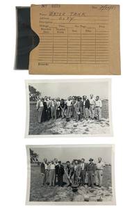
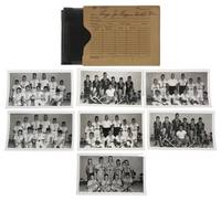
1950réf. 238291950. The evolution of public and civic ceremonies in Clearwater Florida 1951 to 1954 documenting the ceremonies political activity public institutions youth programs infrastructure projects and residential life through which served critical and symbolic functions in the rapid expansion of Sunbelt cities. George Fulmer photographed Clearwater near the beginning of an extraordinary demographic transformation when the city grew from 15581 residents in 1950 to 34653 in 1960 an increase of 122.4 percent. His assignments record that expansion at street level where campaigns elections welfare organizations public works graduations parades and civic gatherings supplied the institutional framework of a developing Sunbelt community. Photo archive of approximately 94 items comprising 46 silver gelatin photograph prints with 46 corresponding large negatives housed in 12 numbe"red commercial photo studio envelopes bearing manuscript assignment captions Clearwater Florida principally 1951 to 1954. Silver gelatin photograph prints ranging from 4.5 x 2.5" to 5" x 4" and each negative about 4 x 5 inches. Fulmer's photographs show crowds of both men and women registering or voting among curtained booths; men breaking ground for a city water tank; officials planting a camellia at the county courthouse; a large men's banquet and presentation ceremony; a high school graduation with students filling a decorated auditorium stage; young women in performance costumes; and children and teenagers posed outside a local theater. Political assignments include a 1952 Alto Adams gubernatorial campaign rally outside the Bank of Clearwater with women wearing "Alto Adams" hats campaign posters surrounding the speaker's platform and spectators lining the sidewalk; Republican gatherings beneath American flags and a portrait of Abraham Lincoln; and Eisenhower campaign volunteers holding "Eisenhower" and "I like Ike" placards outside a Clearwater business. Another series follows a street parade with marching participants balloons decorated vehicles storefronts and spectators while the envelope is captioned "Youth parade." Fulmer also photographed the Clearwater Welfare Center at 612 where a sign identifies the facility as "Sponsored by the Seventh day Adventist Church" recording a public ceremony at its entrance before an audience of adults and children. The studio envelopes retain captions including "Election day voting" "County court house camellia planting" "Alto Adams for Gov" "Eisenhower for Pres" and "Republican speaker" connecting individual negatives and prints to the assignments under which Fulmer produced them. Clearwater's postwar expansion belongs to the larger redistribution of American population and political influence toward Florida and the Sunbelt but Fulmer's assignments establish that transformation through municipal and community activity. Elections are particularly prominent. In 1952 Dwight D. Eisenhower carried Florida with 544036 votes 55 percent of the statewide total becoming part of a changing political landscape in a state long dominated by Democrats. The gubernatorial photographs belong to the same election year: Alto Adams campaigned for the Democratic nomination in a contest ultimately won by Dan McCarty who became governor in January 1953 while contemporary Florida photographic collections similarly record rallies and campaign activity surrounding that election. Fulmer's numbered envelopes demonstrate the process by which such events entered the local photographic record placing presidential and gubernatorial politics beside voting rooms welfare work school ceremonies youth recreation courthouse landscaping water infrastructure parades and residential scenes. Light handling wear and occasional curling; studio envelopes with expected toning handling wear creasing and manuscript notations. Overall in good condition. unknown
réf. 5557176-nnew. unknown
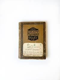
1969réf. 0010041Madison Georgia. Good with no dust jacket. 1969. Hardcover. On offer is a 1969-1970 American diary from 71-year-old Florida Lamar Poullain Campbell Prior of Madison Georgia. Prior was the descendant of the Poullain and Lamar families who have called Georgia home since the early 1700s. Prior was born in Madison in 1898 and lived her life in that community. She married Walter Truman Prior and had a daughter named Florida C. Prior Jr. Prior passed away in 1991 at the age of 93. Although her name is not inscribed on the book context and the individuals named in her entries point to Priors identity. This diary was printed in 1925 but entries were sporadically made between 1969 and 1970. Prior's writing paints a detailed picture of life in the American South at this time. Personal relationships were very important to Prior and her entries are replete with references to family and friends. She also describes the social events that she participates in and the simple pleasures she experiences in her daily life. "Roy M. Prior passed away around 6: 00 AM. Today. He was my sweet and true friend. We will miss him. Ruth has stayed with us some during his illness and Flo & I have enjoyed being with her" April 11. "Today Florida C Prior Jr & Myself watched astronauts Neil Armstrong & Edwin Aldrin Jr. Walk on the moon & heard Pres. Nixon talk to them from Washington and heard their reply to him. UNBELIEVABLE" July 20. "Claire Stovall Inez W. Kroger Georgia Mallory Marguerite Little Helen de Beaugrine Fanny Harris & Ruth Attaway had lunch with me at Ye Olde Colonial Restaurant. We missed Martha Rhoades & Sara Knight who could not be with us. I enjoyed these sweet friends" July 25. "Mell Burgess Paine invited Flo & I to come to Decater for the day & to go to new S. DeKalb Richs. We took morning train for Atlanta -- first time I have been on this train in over 45 years. It was a great experience" August 20. "Elizabeth Cochran Prior & Roy Prior were married this afternoon at the Apalachee Baptist Church. Martha & Paul Rhoades went with Flo & me. It was very sweet" November 8. The diary measures 7 inches by 5 inches contains 183 pages and is approximately 20 percent complete. The cover binding and pages are all in good condition and the handwriting is quite legible. This small diary offers an interesting grouping of family and friendship links that can flesh out genealogical lines in this historic community and county in Georgia. It also offers insight into life in the South at a time when Americans were landing on the moon and experiencing major social upheaval. ; Manuscripts; 7" x 5"; 183 pages; Keywords: Florida Campbell Prior; Lamar; Lamer; Madison Oaks Inn; 766 East Avenue; Poullain Heights; Morgan County; American South; Georgia; Madison; Historic; The South; Scull Shoals; Antoinne Poullain; Rebecca Lamar; Sarah Poullain Campbell; Thomas Poullain; Ye Olde Colonial Restaurant; Apalachee Baptist Church; Moon Landing; Moon Walk; Neil Armstrong; Edwin Aldrin Jr; Buzz Aldrin; AMERICANA; HANDWRITTEN; MANUSCRIPT; DOCUMENT; LETTER; AUTOGRAPH; WRITER; HAND WRITTEN; DOCUMENTS; SIGNED; LETTERS; MANUSCRIPTS; DIARY; DIARIES; JOURNALS; PERSONAL HISTORY; SOCIAL HISTORY; HISTORICAL; HOLOGRAPH; WRITERS; AUTOGRAPHS; PERSONAL; MEMOIR; MEMORIAL; ANTIQUITÉ CONTRAT; VÉLIN; DOCUMENT; MANUSCRIT; PAPIER ANTIKE; BRIEF; PERGAMENT; DOKUMENT; MANUSKRIPT; PAPIER OGGETTO D'ANTIQUARIATO; ATTO; VELINA; DOCUMENTO; MANOSCRITTO; CARTA ANTIGÜEDAD; HECHO; VITELA; DOCUMENTO; MANUSCRITO; PAPEL . hardcover
1872réf. 31647Tallahassee: Charles H. Walton State Printer 1872. Stitched untrimmed and uncut. 350 2 blanks 76 pp. Except for a spotted title page which is chipped at the blank corners a clean Very Good copy. An informative Journal recounting Floridians' resistance to Radical Reconstruction. Governor Harrison Reed's Message addresses ongoing disturbances and "fatal and disgraceful violence. Nine-tenths of the suffering induced has fallen upon Republicans and mainly upon colored citizens-- giving unerring evidence that these excesses have been strongly tinctured by if they have not entirely originated in political prejudice." Many murders and disruptions had occurred in Calhoun and Jackson Counties forcing citizens to flee their homes and seek shelter in other parts of the State. A Committee of Five was appointed "to examine into the cause of said murders and to ascertain why the perpetrators have not been brought to justice." The Committee concluded that "there exists an organized band whose object is to resist the laws and who are the supposed authors of the many murders and outrages committed in the county." Threats of violence and a "reign of terror" had deterred witnesses from coming forward. In Jackson County "no less than one hundred and eighty -four murders fifteen of the number being women and children and almost the entire number being colored people brutally assassinated by this band of outlaws for daring to think for themselves." Similar outrages occurred in Lafayette and other counties. Governor Reed Florida's governor from 1868-73 faced impeachment charges from this Assembly as he had in 1868 and 1870. He was later charged in sixteen Articles with illegally issuing state bonds embezzlement and bribery. The charges were dismissed. The Assembly treated other matters of government including special elections marred by violence; "an act to incorporate Brown's Theological Institute" now Edward Waters College founded in 1866 to educate former slaves and considered the oldest historically black college in Florida. Senate Bill No 82 "to be entitled an act to incorporate the Buckingham Smith Asylum for the colored people of St. Augustine" was passed. Charles H. Walton, State Printer unknown
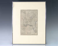
1797réf. 139014Paris: Rigobert Bonne 1797. Rare 18th century map of North America by Royal Hydrographer Rigobert Bonne. One page the engraved map extends from Illinois to Florida with one of the earliest insets of Kansas City. Born in the Lorraine region of France French cartographer Rigobert Bonne 1727-1794 was a skilled cartographer and hydrographer and succeeded Jacques Nicolas Bellin as Royal Hydrographer at the Depot de la Marine in 1773. He published many charts for the Depot including some of those for the Atlas Maritimeof 1762. In near fine condition. Matted and framed. The entire piece measures 17 inches by 16 inches. La Louisiane named after Louis XIV of France became a colony of the Kingdom of France in 1682 before passing to Spain in 1763. Louisiana was formed in part of the became part of the Louisiana Purchase from France in 1803. The U.S. would divide that area into two territories the Territory of Orleans which formed what would become the boundaries of Louisiana and the District of Louisiana. Louisiana was admitted as the 18th state of the United States on April 30 1812. Appointed hydrographer of the French Navy at the age of eighteen Jacques-Nicolas Bellin was appointed Hydrographer to the King in 1741. He published numerous sea atlases and charts which would be reprinted into the nineteenth century as well as many maps depicting French colonial territories in the New World. His craftsmanship and commitment to accuracy earned him a distinguished reputation as one of the world's leading cartographers and many other European mapmakers turned to him for source material. Rigobert Bonne unknown
1916réf. 40686Washington D.C.: Published by the United States Coast and Geodetic Survey 1916. Nautical chart printed on heavy paper stock. Colored. A rare coastal survey of the St. Johns River near Orlando with an inset map of the river continuation in the bottom left corner. Established by President Thomas Jefferson in 1807 as the Survey of the Coast the U.S. Coast and Geodetic Survey was the United States' first civilian scientific agency. This agency has followed its mission to survey the U.S. coastline create nautical charts of the coast and help increase maritime safety since its founding and has often played fascinating roles in significant chapters of U.S. history. It served in all theaters of the Civil War in the service of the Union Army and Navy pioneered acoustic exploration in the wake of the sinking of the Titanic and during WWI it worked to detect enemy submarines. In addition this agency worked to survey and produce detailed maps and renderings of the U.S. coast. These nautical survey maps commonly referred to as "T-sheets" provide fascinating insights into the history of the United States coastline which has and will continue to shift. These maps are the most important data source for understanding the physical and ecological characteristics of the U.S. shoreline. The present map is a highly detailed and accurate sea chart of the St Johns River and an important historical view of a developing Florida. Published by the United States Coast and Geodetic Survey unknown
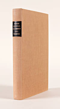
1861réf. 19664Tallahassee. 1861. Floridian Confederate imprint recording the House proceedings at the start of the Civil War. Modern cloth leather label. Very good. PARRISH & WILLINGHAM 2745. SERVIES 4586. hardcover
1986réf. x-0471826456Wiley-Interscience 1986. Hardcover. New. 1st edition. 594 pages. 10.00x7.00x1.50 inches. Wiley-Interscience hardcover
réf. 3242Scarce. Black paper wraps. Photograph and title printed in silver to front cover. Front fly made of silver paper. Organized by architect featuring photographs renderings and floorplans of commercial and residential projects located in South Florida including Miami Miami Beach Coral Gables Ft. Lauderdale and Palm Beach; Hobe Sound and Winter Park circa mid/late 30's. Last third of book consists of advertisements for architects contractors designers landscapers and building materials and manufacturers. A nice clean crisp copy without previous owners' names or other markings. ; 4to 11" - 13" tall; 106 54 pages; All shipments through USPS insured Priority Mail. The Miami Visitor Publishing Co., Inc. paperback
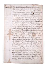
1767réf. 351783New Providence Bahamas 1767. 2pp folded folio sheet with integral blank. Old folds minor staining. 2pp folded folio sheet with integral blank. The Brigatine Apollo left the bay of Honduras on 11 June 1767 bound for Rhode Island on a course through the Gulf of Florida. "That about one of the clock in the morning of the day following the said Brigantine got on the reef of Florida whereupon the deponents immediately got out the said Brig.t's long boat and carried out an anchor in order to heave her off & likewise lightened the vessell by throwing over board some of her cargo: That at six of the clock the said brigatine began to leak very much & at eight o'clock these deponents discovered a vessell in shore which soon after came to their assistance & prov'd to be a sloop belonging to New Providence . having attempted in vain to get the said vessell off & the tide then flowing into her they thought it absolutely necessary to endeavor to save whatever they possibly could of the said Brigatine & her cargo and accordingly proceeded to unbend the sails & strip the said vessell . and do hereby solemnly protest aginst the said reef of Florida for all losses damages & expences hitherto sustained thereby ." The document does not specify the nature of the cargo going from British Honduras to Rhode Island but was perhaps mahogany or other timber used in colonial New England for cabinet making. unknown
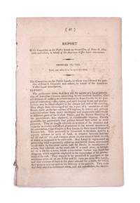
1822réf. 339148Washington D.C.: Gales & Seaton 1822. 17th Congress 1st Session House Report No. 47. 35 1 blankpp. 8vo. Disbound. 17th Congress 1st Session House Report No. 47. 35 1 blankpp. 8vo. A request that the association formed by Chazotte be allowed to purchase land in the Key Largo area for the purpose of cultivating coffee cocoa and tropical fruits. Pages 13 through 30 comprise a separate section with its own caption title: Facts and Observations on the Culture of Vines Olives Capers Almonds &c. in the Southern States and of Coffee Cocoa and Cochineal in East Florida. This section first published separately in Philadelphia in 1821. Shoemaker 11210 [Gales & Seaton] unknown
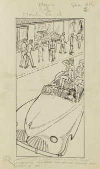
1949réf. 313357Gainesville Fla 1949. Aprox 77 pen and ink drawings with the newspaper cliping done generally for Wednesdays and Sundays. 8vo & 4to. In spiral rink notebook. Aprox 77 pen and ink drawings with the newspaper cliping done generally for Wednesdays and Sundays. 8vo & 4to. unknown
1922réf. 64060Tallahassee FL & Buffalo & New York NY: Department of Agriculture Florida The Matthews-Northrup Works 1922. One large oblong double-atlas folio colour lithograph map sized 50 x 44 in. county lines and railroad lines demarcated in colours fold creases as issued minor dustsoiling edgewear to verso some very slight weakening to a couple fold creases otherwise a VG bright copy. First edition thus of this uncommon and updated sectional map of Florida incorporating the 1920 census numbers as well as updating the agricultural statistics farm properties and average acreage values at the outset of the Roaring 20’s. Also delineated are the railroads reaching into Florida including the Atlantic Coast Line Florida East Coast RR Seaboard Air Lines Georgia Southern & FLorida RR Louisville 7 Nashville RR and others. McRae 1870-1943 headed the Florida Department of Agriculture from 1912-1923. Worldcat locates 2 physical copies U of FL WI Hist. Soc. Department of Agriculture, Florida, The Matthews-Northrup Works, unknown
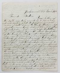
1858réf. 4106Jacksonville Fl: March 15 1858. Very good plus. 4pp. on a single folded sheet. Old mailing folds. An informative dispatch from antebellum Florida from A.C Scranton to "Friend Barton" in 1858. In his letter Scranton reports that despite some problems he is enjoying southern people and general life in Florida: "The people generally in the south are very kind & hospitibal but I need hardly to tell you that Florida has got some hard times as every new state or Territory has but thare is a more healthy Emigration coming in every year I have been fortunate anough to find some Northern people here which makes it seam a little more like home to me. I am boarding with a family from Georgia whome I like first rate & I do just as I would at home so that things are quite pleasant here considering I am amongst strangers." He then provides information on Jacksonville and then two disasters that hit his adopted hometown: "Jacksonville is the largest place in Florida & had at one time about 3000 inhabitants it is not as large as it was once some three years ago it was visited by a very destructive fire & burned nearly half of the town. Last summer there was some kind of Fever here that almost prostrated the place some called it the Yellow Fever & some the African but none could tell for certin.about a hundred & fifteen or twenty that died here in 3 months & a grate many left the town nearly all the stors wer closed not a sound of a hammer was to be heard. When cold weather came it stoped the sickness and it seams quite lively now. It has been for many years a grate resort in the winter season for invaleds but on account of the sickness last summer thare are but few this winter if it continus healthy this summer the place will revive but if not it will kill it entirely." Scranton also discusses the transportation system that served Jacksonville and the recent winding down of the Seminole Wars: "It is situated on the Johns River about 23 miles from the mouth and is connected with Charleston & Savana by a regular line of steamers that runs up the river a hundred miles to a place called Platka whare Emigrants land & then travel by land to the interior to settle the country thare is a railroad building from this place to Tallahasse the capital of the state a distance of a hundred & eighty miles which wen completed will be a little help to this place. There is also another in progress from Fernandina a new town that lays in the North East corner of the state to a place called cedar keys on the gulf side whare they intend to carry the US mail direct from New Orleans to New York insted of going round by Key west & will shorten the time considerable. Florida has cost Uncle Sam a large some of money.the government.will make a treaty with them & send them into the Indian Territory & then close the Indian war in Florida." Almost all of the Seminoles remaining in Florida relocated to Indian Territory in the year this letter was written. A wonderfully-detailed firsthand account of Jacksonville and its development and challenges during the late 1850s. A printed transcription accompanies the letter. March 15 unknown
1959réf. ZB705266Florida Association of Architects / Roger W. Sherman 1959. Price HAS BEEN REDUCED by 10% until Monday Nov. 2 weekend sale item Volumes 9 through 26 1959-1976 lacking volume 11#11; 12#12; Bound in buckram with original covers included except for the issues for volume 11 & 12 which are unbound in original wrappers. Ex library text clean & bindings tight. - If you are reading this this item is actually physically in our stock and ready for shipment once ordered. We are not bookjackers. Buyer is responsible for any additional duties taxes or fees required by recipient's country. Photos available upon request. Florida Association of Architects / Roger W. Sherman hardcover
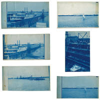
1895réf. 3633601895. Five views of Lake Worth Beach and Palm Beach in 1895. The images are: 1 Ferry at Lake Worth with the Royal Poinciana Hotel in the distance. Captioned in the negative "L.W.B. 9.14.95"; 2 Lake Worth with the Royal Poinciana Hotel in the distance. Captioned in the negative "L.W.B. 9.24.95"; 3 View of Lake Worth with a pier in the foreground possibly taken from a boat. Captioned in the negative "L.W.B. 10.9.95"; 4 Sail boat in front of the Royal Poinciana captioned in the negative "Lake Worth" two versions with different exposure times 5 View of the Palm Beach Inn later renamed The Breakers under construction with the Royal Poinciana in the background not dated but the hotel opened in December 1895. The negatives these views were printed from are of somewhat unusual size measuring roughly 4-3/4 by 7-3/4 inches. All but one view have a horizontal orientation. Given that this size does not seem to conform to the standard halfplate negative usually 5-1/2 to 6-1/2 inches in the long direction one might speculate that the photographer made their own camera. The photographs are handcut with somewhat uneven edges and of varying finished sizes all roughly 5 by 8 inches. They are generally very good or better with some toning and spotting. Uncommon subject matter. unknown
1921réf. 40736Washington D.C.: Published by the United States Coast and Geodetic Survey 1921. Large folding nautical chart printed on heavy paper stock. Colored. A rare original coastal survey of Florida and Alabama from Pensacola Bay showing Perdido Bay including Pensacola Perdido Key and Orange Beach. Established by President Thomas Jefferson in 1807 as the Survey of the Coast the U.S. Coast and Geodetic Survey was the United States' first civilian scientific agency. This agency has followed its mission to survey the U.S. coastline create nautical charts of the coast and help increase maritime safety since its founding and has often played fascinating roles in significant chapters of U.S. history. It served in all theaters of the Civil War in the service of the Union Army and Navy pioneered acoustic exploration in the wake of the sinking of the Titanic and during WWI it worked to detect enemy submarines. In addition this agency worked to survey and produce detailed maps and renderings of the U.S. coast. These nautical survey maps commonly referred to as "T-sheets" provide fascinating insights into the history of the United States coastline which has and will continue to shift. These maps are the most important data source for understanding the physical and ecological characteristics of the U.S. shoreline. The present map is a highly detailed and accurate sea chart of the coastal border between Florida and Alabama and an important historical view of the developing states. Published by the United States Coast and Geodetic Survey unknown
1917réf. 40710Washington D.C.: Published by the United States Coast and Geodetic Survey 1917. Folding nautical chart printed on heavy paper stock. Uncolored. A rare original coastal survey of Florida's Cedar Keys area. Established by President Thomas Jefferson in 1807 as the Survey of the Coast the U.S. Coast and Geodetic Survey was the United States' first civilian scientific agency. This agency has followed its mission to survey the U.S. coastline create nautical charts of the coast and help increase maritime safety since its founding and has often played fascinating roles in significant chapters of U.S. history. It served in all theaters of the Civil War in the service of the Union Army and Navy pioneered acoustic exploration in the wake of the sinking of the Titanic and during WWI it worked to detect enemy submarines. In addition this agency worked to survey and produce detailed maps and renderings of the U.S. coast. These nautical survey maps commonly referred to as "T-sheets" provide fascinating insights into the history of the United States coastline which has and will continue to shift. These maps are the most important data source for understanding the physical and ecological characteristics of the U.S. shoreline. The present map is a highly detailed and accurate sea chart of Florida's Cedar Keys and an important historical view of a developing Florida. Published by the United States Coast and Geodetic Survey unknown
1917réf. 40726Washington D.C.: Published by the United States Coast and Geodetic Survey 1917. Nautical chart printed on heavy paper stock. Uncolored with minor wear. A rare original coastal survey of the Legare Anchorage in Florida's Biscayne Bay with Elliot Key and Sands Key. Established by President Thomas Jefferson in 1807 as the Survey of the Coast the U.S. Coast and Geodetic Survey was the United States' first civilian scientific agency. This agency has followed its mission to survey the U.S. coastline create nautical charts of the coast and help increase maritime safety since its founding and has often played fascinating roles in significant chapters of U.S. history. It served in all theaters of the Civil War in the service of the Union Army and Navy pioneered acoustic exploration in the wake of the sinking of the Titanic and during WWI it worked to detect enemy submarines. In addition this agency worked to survey and produce detailed maps and renderings of the U.S. coast. These nautical survey maps commonly referred to as "T-sheets" provide fascinating insights into the history of the United States coastline which has and will continue to shift. These maps are the most important data source for understanding the physical and ecological characteristics of the U.S. shoreline. The present map is a highly detailed and accurate sea chart of the Biscayne Bay region and an important historical view of a developing Florida. Published by the United States Coast and Geodetic Survey unknown
1917réf. 40713Washington D.C.: Published by the United States Coast and Geodetic Survey 1917. Large folding nautical chart printed on heavy paper stock. Uncolored. Coastal survey map of Tortugas Harbor and approaches with an inset map in the upper left corner of Fort Jefferson. Established by President Thomas Jefferson in 1807 as the Survey of the Coast the U.S. Coast and Geodetic Survey was the United States' first civilian scientific agency. This agency has followed its mission to survey the U.S. coastline create nautical charts of the coast and help increase maritime safety since its founding and has often played fascinating roles in significant chapters of U.S. history. It served in all theaters of the Civil War in the service of the Union Army and Navy pioneered acoustic exploration in the wake of the sinking of the Titanic and during WWI it worked to detect enemy submarines. In addition this agency worked to survey and produce detailed maps and renderings of the U.S. coast. These nautical survey maps commonly referred to as "T-sheets" provide fascinating insights into the history of the United States coastline which has and will continue to shift. These maps are the most important data source for understanding the physical and ecological characteristics of the U.S. shoreline. The present map is inset with a detailed view of Fort Jefferson on Garden Key. Fort Jefferson was an ambitious civil war era coastal defence site which became the largest brick structure in the US. This map is a highly detailed and accurate sea chart of Tortugas Harbor and an important historical view of a developing Florida. Published by the United States Coast and Geodetic Survey unknown
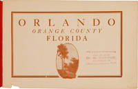
1910réf. 62983St. Augustine: The Record Company ca. 1910. An Early Promotional Booklet for the City Beautiful An early promotional booklet issued by the Orlando Board of Trade encouraging "all newcomers" to "visit this beautiful little city by the lakes." In an effort "to secure tourists winter and permanent residents" the publication touts the city's "superior advantages" "especially in point of situation climate freedom from troublesome insects up-to-date business houses comfortable dwellings good hotels healthfulness paved and shaded streets good schools and churches fine sporting accommodations best drinking water on earth and many other advantages too numerous to mention." The booklet is richly illustrated with halftones from photographs depicting a variety of natural civic and commercial landmarks as well as people engaged in a range of recreational activities. Among other things the illustrations show Orange Avenue the San Juan Hotel people playing golf and lawn tennis a match at the Orlando Polo Club horse-racing and the track of the Orlando Driving Park Association the recently inaugurated Automobile Carnival a newly constructed public school building the Orange County Courthouse various city churches the Rosalind Club House a young woman posing in front of a grapefruit tree and agricultural laborers working in a celery field. Also included are various images of tree-lined streets and the city's many lakes including Lake Sue Lake Minnie Lake Lucerne Lake Eola and Lake Highland. Most of the illustrations were likely taken from photographs by Clarence E. Howard 1858-1930. A native of Pennsylvania Howard first arrived in Orange County Florida in 1883 before settling permanently in Orlando in 1904. There he worked in the publishing business and as a photographer. He edited a number of publications including the Orlando Star the Orange County Reporter the Reporter-Star the Sentinel and later owned and edited the Orange County Citizen. He was active in the civic life of the community serving twelve years as city alderman and as chairman of the District School Trustees. Notably Howard was also for several years secretary of the Orlando Board of Trade the body responsible for producing the present publication. Howard is buried at Orlando's historic Greenwood Cemetery. The date of publication can be roughly surmised from a reference to an "Automobile Carnival" inaugurated a year prior to publication. We find a reference to the Orlando "Automobile Parade" in the Automobile Blue Book from as early as 1912. The present publication must therefore predate that. This copy bears an inkstamp on the titlepage saying that further information could be had from D.S. Shine of Jacksonville. An intriguing and early glimpse of life in Orlando long before it became an international tourist destination. Oblong octavo. Original publisher's red wrappers stapled title in raised gilt letters on front wrapper. Wrappers lightly faded and soiled. Small chip to bottom edge of front wrapper and title leaf not affecting text. Old stamp in purple ink to titlepage see below. Very good. OCLC 882242309. OCLC 1750611. C.E. Howard Early Settlers of Orange County Florida; Reminiscent Historic Biographic Orlando 1915 p.2. The Automobile Blue Book: A Touring Hand-Book of the Most Practicable Routes in Pennsylvania New Jersey and the South Atlantic States New York 1912 p.774. unknown
1951réf. 237921951. Largo Florida photograph archive taken by George Fulmer c. 1951 documenting education youth culture housing commerce religion and recreation as a citrus and farming community entered the first phase of its postwar transformation into a suburban city. Largo's population and physical landscape changed rapidly after World War II as groves and grazing land gave way to housing and industrial development; within the wider Pinellas County school system enrollment rose from roughly 16000 students in 1946 to about 69000 in 1962 requiring the construction of 64 new schools between 1948 and 1965. The photographs concentrate unusually closely on the generation educated during this transition recording Largo High School athletics Future Farmers of America Future Homemakers of America youth baseball school music and other organized activities at the moment when the occupational and domestic assumptions of an agricultural community were meeting the demographic and economic conditions of suburban Florida. Photo archive of approximately 87 items including 38 silver gelatin photographs and approximately 38 corresponding large format negatives photograph prints ranging from 4.5 x 2.5 to 5 x 4 inches and each negative about 4 x 5 inches all retained in 11 original numbered photographic job envelopes bearing client subject and occasional date notations Largo Florida principally 1951. The photographs and negatives were made by George Fulmer the longtime Clearwater commercial and civic photographer whose surviving files document decades of local institutional life in central Pinellas County. The original job envelopes preserve Fulmer's assignment structure linking negatives and prints to named Largo clients and subjects rather than leaving the photographs as unidentified local views. The school material includes a large Largo High School Future Homemakers of America group posed beneath the organization's emblem; young women displaying and examining patterned skirts and clothing outdoors; a group identified on its envelope as "Largo High School Boys Girls FFA & FHA"; and children and adolescents posed beneath a sign reading "Largo Chapter Future Farmers of America Department of Vocational Agriculture" some holding hoes shovels and other agricultural implements. Football assignments show night games under field lights players running tackling and breaking through defensive lines referees moving through plays crowded grandstands cheerleaders and a large uniformed marching band packed into the bleachers. Other files document Largo Junior League baseball teams posed with bats gloves coaches and locally lettered uniforms; a Largo Baptist Church choir arranged in the sanctuary; Sinclair gasoline station employees receiving a trophy beside an HC gasoline pump; new residential and commercial buildings; and modern domestic interiors furnished with low upholstered seating lamps paneled walls and contemporary cabinetry. Most negatives duplicate surviving prints. The Largo recorded here was still closely identified with agriculture. Citrus cattle and dairy had dominated the local economy through much of the early twentieth century and Largo had developed into one of Florida's major citrus centers after the arrival of the railroad; within a few years of these photographs freezes in 1957 and 1962 damaged the citrus economy while population growth increased demand for residential and commercial land. Largo High School embodied that transition directly. Its own history recalls an educational culture in which young men studied agriculture tractor repair wood shop and animal science while young women took home economics a gendered vocational division visible here in the paired presence of Future Farmers and Future Homemakers. The Future Homemakers photographs record an educational ideal that treated domestic labor clothing food preparation and household management as formal preparation for female adulthood while the FFA material trained boys for an agricultural economy whose physical basis was already beginning to contract. Largo's accelerating growth soon made the older educational infrastructure inadequate: in 1957 a new Largo High School opened taking 37 acres of land. Postwar industrialization accelerated this transformation as Honeywell and General Electric facilities helped move Largo from an agricultural center toward a suburban economy; housing and trailer parks replaced groves and grazing land and by 1970 the city counted roughly 22300 residents up from 5302 in 1960. The apparently all white school organizations also belong to Pinellas County's segregated educational structure: after the 1954 Brown v. Board of Education decision the county nevertheless built nine additional all Black schools between 1954 and 1963 and only about 200 Black students attended desegregated county schools in 1964. The photographs show some curling but remain in very good condition. Some negatives show fading; original paper job envelopes show handling wear. Overall in very good condition. unknown
1988réf. ZB394189Florida International University. 1988-1994. Price HAS BEEN REDUCED by 10% until Monday Nov. 2 weekend sale item volumes 1-2; 6. 1988-1994. partly bound library markings textually clean & tight PRICE IS FOR THE LOT. - If you are reading this this item is actually physically in our stock and ready for shipment once ordered. We are not bookjackers. Buyer is responsible for any additional duties taxes or fees required by recipient's country. Photos available upon request. Florida International University. unknown
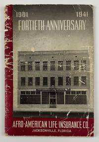
1941réf. 12634N.p. likely Jacksonville Fl. 1941. 4612pp. Original pictorial wrappers stapled. Substantial creasing rubbing dust-soiling and overall wear to wrappers. Faint foxing and spotting to initial and terminal leaves but mostly clean internally. Very good. A rare pamphlet celebrating the fortieth anniversary of the Afro-American Life Insurance Company an important African-American-owned-and-operated insurance company in Florida. The work includes reproductions of congratulatory letters to the company from Florida governor Spessard Holland and others portraits and information on the company’s founders passages on the history of the company information on the successes of the company’s current operations and more. The work is interspersed throughout with a legion of photographs showing the company at work scenes from various branch offices the company’s Funeral Services Division and so forth. "Florida's First African-American Insurance Company -1901-2001. The Afro-American Insurance Company formerly the Afro-American Industrial and Benefits Association was founded in 1901 to provide affordable health insurance and death benefits to the state's African-Americans. Founded by the Reverend E.J. Gregg E.W. Latson Abraham Lincoln Lewis A.W. Price Dr. Arthur W. Smith J.F. Valentine and the Reverend J. Melton Waldron the Afro's first office at 14 Ocean Street was destroyed by the great Jacksonville Fire two months after it opened on May 3 1901. It then moved to 621 Florida Avenue the home of treasurer and future president Abraham Lincoln Lewis 1865-1947. From their next home office at 105 E. Union Street the company wrote millions of dollars of insurance policies and started district offices in Georgia Alabama Louisiana and Texas." - Historical marker at the site of the company's original location in Jacksonville. OCLC reports just two copies at Howard and the University of North Florida. unknown
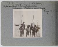
1901réf. 2885Various locations in Florida 1901. About very good. 16 leaves illustrated with thirty-two original vernacular photographs all 3.5 x 3.5 inches most with manuscript captions in ink above the images. Oblong octavo. Contemporary gray paper wrappers white titles on front cover. Spine mostly split a few shallow chips to edges. Internally clean. A small but important vernacular photograph album containing rare views of the devastation wrought by the Great Fire of 1901 in Jacksonville Florida which took place on May 3 1901. The most destructive event in the history of Jacksonville the Great Fire swept through 146 city blocks destroying over 2000 buildings killing seven people and leaving almost 10000 residents without homes. It is considered the third-largest urban fire in United States history after the Great Chicago Fire and the 1906 San Francisco conflagration. The photographs in the present album were taken by an unidentified passenger aboard the Clyde Line steamer Comanche. Eight of the images capture the scene in devastated Jacksonville including a shot of the ruins of the Windsor and St. James hotels shots from atop the "Jacksonville Government Building" a group picture of the city guard "ruins of Jacksonville Court House" "An unknown ruin" a crowded scene at the Jacksonville wharf and a distant shot showing "Ruins of Jacksonville taken from Steamer Comanche May 12." All of the photographs of Jacksonville are dated in manuscript on May 12 1901 nine days after the Great Fire. In addition to the Jacksonville pictures other identified locations along the photographer's voyage include the Hillsborough River near Tampa the Tampa Court House scenes around the Tampa Bay Hotel family pictures in Florida the Comanche and its crew Fort Sumter and four views around Charleston. One particularly notable photograph shows six boys standing in shallow water holding fishing nets likely near Tampa. The image is captioned "A group of young crabbers representing three nationalities American Italian and Negro May 10 1901. unknown