2 555 résultats
1926réf. 55884New York: Harper & Brothers 1926. 8vo. xiv 324 pp. plus 2 pp. publisher’s ads. Photo frontisp. numerous photo plates. Green cloth gilt lettering front cover & spine very minor rubbing slight frying at foot of spine very slight bumping to couple corners w/ d.j. splendid silhouette Art Deco cover art w/ initials RW minor tear at head of spine w/ very minor loss minor sunning still VG/VG- copy. First edition of this fascinating memoir tracing the impact of the Jazz Age on Florida development regaling readers with accounts of the great land rush and crowded steamers headed southward automobile travelers filling nascent highways and the drama of the real estate developers in Miami Coral Gables Hollywood and Boca Raton. Included as well are accounts of the bootleggers gamblers real estate scams and the boom days of the 1920s before the crash of 1929. Exceedingly scarce in original dustjacket. Harper & Brothers, hardcover
1938réf. 57192New York: Sheridan House 1938. 8vo. 287 1 pp. Numerous photo plates colour maps on endpapers. Forest-green tweed boards black lettering colour maps on endpapers minor bumping head of spine slight bumping to couple corners w/ d.j. cover art of the Gypsy Waters under sail couple minor closed tears edgewear still VG/VG- copy. First edition of this author’s memoir detailing the rebuilding and outfitting of a Chesapeake Bay Bugeye ketch he renamed Gypsy Waters and the several adventures with his family to the Bahamas the Gulf Islands the Gulf lakes and rivers of Florida and more. Scarce in original dustjacket. Sheridan House, hardcover
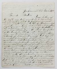
1858réf. 4106Jacksonville Fl: March 15 1858. Very good plus. 4pp. on a single folded sheet. Old mailing folds. An informative dispatch from antebellum Florida from A.C Scranton to "Friend Barton" in 1858. In his letter Scranton reports that despite some problems he is enjoying southern people and general life in Florida: "The people generally in the south are very kind & hospitibal but I need hardly to tell you that Florida has got some hard times as every new state or Territory has but thare is a more healthy Emigration coming in every year I have been fortunate anough to find some Northern people here which makes it seam a little more like home to me. I am boarding with a family from Georgia whome I like first rate & I do just as I would at home so that things are quite pleasant here considering I am amongst strangers." He then provides information on Jacksonville and then two disasters that hit his adopted hometown: "Jacksonville is the largest place in Florida & had at one time about 3000 inhabitants it is not as large as it was once some three years ago it was visited by a very destructive fire & burned nearly half of the town. Last summer there was some kind of Fever here that almost prostrated the place some called it the Yellow Fever & some the African but none could tell for certin.about a hundred & fifteen or twenty that died here in 3 months & a grate many left the town nearly all the stors wer closed not a sound of a hammer was to be heard. When cold weather came it stoped the sickness and it seams quite lively now. It has been for many years a grate resort in the winter season for invaleds but on account of the sickness last summer thare are but few this winter if it continus healthy this summer the place will revive but if not it will kill it entirely." Scranton also discusses the transportation system that served Jacksonville and the recent winding down of the Seminole Wars: "It is situated on the Johns River about 23 miles from the mouth and is connected with Charleston & Savana by a regular line of steamers that runs up the river a hundred miles to a place called Platka whare Emigrants land & then travel by land to the interior to settle the country thare is a railroad building from this place to Tallahasse the capital of the state a distance of a hundred & eighty miles which wen completed will be a little help to this place. There is also another in progress from Fernandina a new town that lays in the North East corner of the state to a place called cedar keys on the gulf side whare they intend to carry the US mail direct from New Orleans to New York insted of going round by Key west & will shorten the time considerable. Florida has cost Uncle Sam a large some of money.the government.will make a treaty with them & send them into the Indian Territory & then close the Indian war in Florida." Almost all of the Seminoles remaining in Florida relocated to Indian Territory in the year this letter was written. A wonderfully-detailed firsthand account of Jacksonville and its development and challenges during the late 1850s. A printed transcription accompanies the letter. March 15 unknown
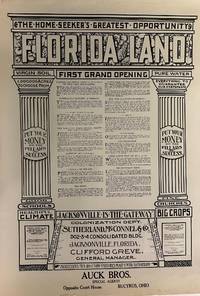
1911réf. 34481Jacksonville FL: Colonization Dept.: Sutherland McConnel & Co 1911. Printed broadside 24 x 18 inches employing several styles and sizes of type the large head 2 1/4 inches within an ornamental border featuring citrus fruit and pineapples. Jacksonville is the gateway good school fine churches healthful climate big crops." An immigration promotional offering more than a million acres to choose from with the first offering being a 27000 acre tract in Duval County. Servies 16187 noting only a privately held copy. OCLC locates three copies: Yale State Lib. of Florida Univ. of North Florida. Very good. #5038. Colonization Dept.: Sutherland, McConnel & Co unknown books
1890réf. 59940Key West FL: Hunt Photographer 211 Duval St. ca. 1890. Oblong 8vo. One albumen photo sized 4.25 x 6.5 in. mounted on printed 5.25 x 8.5 in. boudoir-sized studio board w/ photographer’s imprint in lower margin of board manuscript pencil title on verso minor chipping & slight tears to upper fore-edge of image still a VG- photo w/ bright strong contrast. A scarce 19th-century albumen boudoir photograph capturing the historic fish market in Key West Florida which at the time held a monopoly on the sponge trade in the United States. Beginning with sponges introduced before the Civil War eventually 1200 spongers on hook boats caught up to 2000 tons of sponges a year. At the time turtling or turtle fishing was a significant industry and the Charter Fishing Boat presence was still quite small and would eventually grow during the Progressive Era drawing ever greater numbers of tourists. Hunt fl. 1880-1900 in Key West Florida operated a photography studio at 211 Duval for over a decade and was originally from Indiana. Hunt, Photographer, 211 Duval St., unknown
1911réf. 34481Jacksonville FL: Colonization Dept.: Sutherland McConnel & Co 1911. Printed broadside 24 x 18 inches employing several styles and sizes of type the large head 2 1/4 inches within an ornamental border featuring citrus fruit and pineapples. Jacksonville is the gateway good school fine churches healthful climate big crops." An immigration promotional offering more than a million acres to choose from with the first offering being a 27000 acre tract in Duval County. Servies 16187 noting only a privately held copy. OCLC locates three copies: Yale State Lib. of Florida Univ. of North Florida. Very good. #5038. Colonization Dept.: Sutherland, McConnel & Co unknown
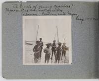
1901réf. 2885Various locations in Florida 1901. About very good. 16 leaves illustrated with thirty-two original vernacular photographs all 3.5 x 3.5 inches most with manuscript captions in ink above the images. Oblong octavo. Contemporary gray paper wrappers white titles on front cover. Spine mostly split a few shallow chips to edges. Internally clean. A small but important vernacular photograph album containing rare views of the devastation wrought by the Great Fire of 1901 in Jacksonville Florida which took place on May 3 1901. The most destructive event in the history of Jacksonville the Great Fire swept through 146 city blocks destroying over 2000 buildings killing seven people and leaving almost 10000 residents without homes. It is considered the third-largest urban fire in United States history after the Great Chicago Fire and the 1906 San Francisco conflagration. The photographs in the present album were taken by an unidentified passenger aboard the Clyde Line steamer Comanche. Eight of the images capture the scene in devastated Jacksonville including a shot of the ruins of the Windsor and St. James hotels shots from atop the "Jacksonville Government Building" a group picture of the city guard "ruins of Jacksonville Court House" "An unknown ruin" a crowded scene at the Jacksonville wharf and a distant shot showing "Ruins of Jacksonville taken from Steamer Comanche May 12." All of the photographs of Jacksonville are dated in manuscript on May 12 1901 nine days after the Great Fire. In addition to the Jacksonville pictures other identified locations along the photographer's voyage include the Hillsborough River near Tampa the Tampa Court House scenes around the Tampa Bay Hotel family pictures in Florida the Comanche and its crew Fort Sumter and four views around Charleston. One particularly notable photograph shows six boys standing in shallow water holding fishing nets likely near Tampa. The image is captioned "A group of young crabbers representing three nationalities American Italian and Negro May 10 1901. unknown
1901réf. 2885Various locations in Florida 1901. About very good. 16 leaves illustrated with thirty-two original vernacular photographs all 3.5 x 3.5 inches most with manuscript captions in ink above the images. Oblong octavo. Contemporary gray paper wrappers white titles on front cover. Spine mostly split a few shallow chips to edges. Internally clean. A small but important vernacular photograph album containing rare views of the devastation wrought by the Great Fire of 1901 in Jacksonville Florida which took place on May 3 1901. The most destructive event in the history of Jacksonville the Great Fire swept through 146 city blocks destroying over 2000 buildings killing seven people and leaving almost 10000 residents without homes. It is considered the third-largest urban fire in United States history after the Great Chicago Fire and the 1906 San Francisco conflagration. The photographs in the present album were taken by an unidentified passenger aboard the Clyde Line steamer Comanche. Eight of the images capture the scene in devastated Jacksonville including a shot of the ruins of the Windsor and St. James hotels shots from atop the "Jacksonville Government Building" a group picture of the city guard "ruins of Jacksonville Court House" "An unknown ruin" a crowded scene at the Jacksonville wharf and a distant shot showing "Ruins of Jacksonville taken from Steamer Comanche May 12." All of the photographs of Jacksonville are dated in manuscript on May 12 1901 nine days after the Great Fire. In addition to the Jacksonville pictures other identified locations along the photographer's voyage include the Hillsborough River near Tampa the Tampa Court House scenes around the Tampa Bay Hotel family pictures in Florida the Comanche and its crew Fort Sumter and four views around Charleston. One particularly notable photograph shows six boys standing in shallow water holding fishing nets likely near Tampa. The image is captioned "A group of young crabbers representing three nationalities American Italian and Negro May 10 1901. unknown books
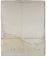
1916réf. 40717Washington D.C.: Published by the United States Coast and Geodetic Survey 1916. Large folding nautical chart printed on heavy paper stock. Uncolored. Rare original coastal survey of Florida's Apalachee bay. Established by President Thomas Jefferson in 1807 as the Survey of the Coast the U.S. Coast and Geodetic Survey was the United States' first civilian scientific agency. This agency has followed its mission to survey the U.S. coastline create nautical charts of the coast and help increase maritime safety since its founding and has often played fascinating roles in significant chapters of U.S. history. It served in all theaters of the Civil War in the service of the Union Army and Navy pioneered acoustic exploration in the wake of the sinking of the Titanic and during WWI it worked to detect enemy submarines. In addition this agency worked to survey and produce detailed maps and renderings of the U.S. coast. These nautical survey maps commonly referred to as "T-sheets" provide fascinating insights into the history of the United States coastline which has and will continue to shift. These maps are the most important data source for understanding the physical and ecological characteristics of the U.S. shoreline. The present map of the Florida coastline is notable for the inclusion of St Marks light house built at the head of the St Marks River to assist in navigation to and from the important 19th century agricultural port of St Marks. This map is a highly detailed and accurate sea chart of the Apalachee Bay from Fish Creek to Alligator Point and an important historical view of a developing Florida. Published by the United States Coast and Geodetic Survey unknown
1916réf. 40680Washington D.C.: Published by the United States Coast and Geodetic Survey 1916. Large folding nautical chart printed on heavy paper stock. Colored. A rare coastal survey of Apalachee Bay including Alligator Point and St. George Island. Established by President Thomas Jefferson in 1807 as the Survey of the Coast the U.S. Coast and Geodetic Survey was the United States' first civilian scientific agency. This agency has followed its mission to survey the U.S. coastline create nautical charts of the coast and help increase maritime safety since its founding and has often played fascinating roles in significant chapters of U.S. history. It served in all theaters of the Civil War in the service of the Union Army and Navy pioneered acoustic exploration in the wake of the sinking of the Titanic and during WWI it worked to detect enemy submarines. In addition this agency worked to survey and produce detailed maps and renderings of the U.S. coast. These nautical survey maps commonly referred to as "T-sheets" provide fascinating insights into the history of the United States coastline which has and will continue to shift. These maps are the most important data source for understanding the physical and ecological characteristics of the U.S. shoreline. The present map is a highly detailed and accurate sea chart of the Apalachee Bay and an important historical view of a developing Florida. Published by the United States Coast and Geodetic Survey unknown
1916réf. 40717Washington D.C.: Published by the United States Coast and Geodetic Survey 1916. Large folding nautical chart printed on heavy paper stock. Uncolored. Rare original coastal survey of Florida's Apalachee bay. Established by President Thomas Jefferson in 1807 as the Survey of the Coast the U.S. Coast and Geodetic Survey was the United States' first civilian scientific agency. This agency has followed its mission to survey the U.S. coastline create nautical charts of the coast and help increase maritime safety since its founding and has often played fascinating roles in significant chapters of U.S. history. It served in all theaters of the Civil War in the service of the Union Army and Navy pioneered acoustic exploration in the wake of the sinking of the Titanic and during WWI it worked to detect enemy submarines. In addition this agency worked to survey and produce detailed maps and renderings of the U.S. coast. These nautical survey maps commonly referred to as "T-sheets" provide fascinating insights into the history of the United States coastline which has and will continue to shift. These maps are the most important data source for understanding the physical and ecological characteristics of the U.S. shoreline. The present map of the Florida coastline is notable for the inclusion of St Marks light house built at the head of the St Marks River to assist in navigation to and from the important 19th century agricultural port of St Marks. This map is a highly detailed and accurate sea chart of the Apalachee Bay from Fish Creek to Alligator Point and an important historical view of a developing Florida. Published by the United States Coast and Geodetic Survey unknown books
1916réf. 40680Washington D.C.: Published by the United States Coast and Geodetic Survey 1916. Large folding nautical chart printed on heavy paper stock. Colored. A rare coastal survey of Apalachee Bay including Alligator Point and St. George Island. Established by President Thomas Jefferson in 1807 as the Survey of the Coast the U.S. Coast and Geodetic Survey was the United States' first civilian scientific agency. This agency has followed its mission to survey the U.S. coastline create nautical charts of the coast and help increase maritime safety since its founding and has often played fascinating roles in significant chapters of U.S. history. It served in all theaters of the Civil War in the service of the Union Army and Navy pioneered acoustic exploration in the wake of the sinking of the Titanic and during WWI it worked to detect enemy submarines. In addition this agency worked to survey and produce detailed maps and renderings of the U.S. coast. These nautical survey maps commonly referred to as "T-sheets" provide fascinating insights into the history of the United States coastline which has and will continue to shift. These maps are the most important data source for understanding the physical and ecological characteristics of the U.S. shoreline. The present map is a highly detailed and accurate sea chart of the Apalachee Bay and an important historical view of a developing Florida. Published by the United States Coast and Geodetic Survey unknown books
1920réf. 40721Washington D.C.: Published by the United States Coast and Geodetic Survey 1920. Large folding nautical chart printed on heavy paper stock. Uncolored. A rare original coastal survey of Apalachicola Bay and Cape San Blas including St. George Island. Established by President Thomas Jefferson in 1807 as the Survey of the Coast the U.S. Coast and Geodetic Survey was the United States' first civilian scientific agency. This agency has followed its mission to survey the U.S. coastline create nautical charts of the coast and help increase maritime safety since its founding and has often played fascinating roles in significant chapters of U.S. history. It served in all theaters of the Civil War in the service of the Union Army and Navy pioneered acoustic exploration in the wake of the sinking of the Titanic and during WWI it worked to detect enemy submarines. In addition this agency worked to survey and produce detailed maps and renderings of the U.S. coast. These nautical survey maps commonly referred to as "T-sheets" provide fascinating insights into the history of the United States coastline which has and will continue to shift. These maps are the most important data source for understanding the physical and ecological characteristics of the U.S. shoreline. The present map of the Florida coastline precedes the development of the town of Eastpoint and the building of the John Gorrie Memorial Bridge which connects Eastpoint with Apalachicola. The current site of Eastpoint is marked as Godleys Bluff on the present map. This map is a highly detailed and accurate sea chart of the coastal Florida and an important historical view of the developing state. Published by the United States Coast and Geodetic Survey unknown
1920réf. 40721Washington D.C.: Published by the United States Coast and Geodetic Survey 1920. Large folding nautical chart printed on heavy paper stock. Uncolored. A rare original coastal survey of Apalachicola Bay and Cape San Blas including St. George Island. Established by President Thomas Jefferson in 1807 as the Survey of the Coast the U.S. Coast and Geodetic Survey was the United States' first civilian scientific agency. This agency has followed its mission to survey the U.S. coastline create nautical charts of the coast and help increase maritime safety since its founding and has often played fascinating roles in significant chapters of U.S. history. It served in all theaters of the Civil War in the service of the Union Army and Navy pioneered acoustic exploration in the wake of the sinking of the Titanic and during WWI it worked to detect enemy submarines. In addition this agency worked to survey and produce detailed maps and renderings of the U.S. coast. These nautical survey maps commonly referred to as "T-sheets" provide fascinating insights into the history of the United States coastline which has and will continue to shift. These maps are the most important data source for understanding the physical and ecological characteristics of the U.S. shoreline. The present map of the Florida coastline precedes the development of the town of Eastpoint and the building of the John Gorrie Memorial Bridge which connects Eastpoint with Apalachicola. The current site of Eastpoint is marked as Godleys Bluff on the present map. This map is a highly detailed and accurate sea chart of the coastal Florida and an important historical view of the developing state. Published by the United States Coast and Geodetic Survey unknown books
1872réf. 31647Tallahassee: Charles H. Walton State Printer 1872. Stitched untrimmed and uncut. 350 2 blanks 76 pp. Except for a spotted title page which is chipped at the blank corners a clean Very Good copy. An informative Journal recounting Floridians' resistance to Radical Reconstruction. Governor Harrison Reed's Message addresses ongoing disturbances and "fatal and disgraceful violence. Nine-tenths of the suffering induced has fallen upon Republicans and mainly upon colored citizens-- giving unerring evidence that these excesses have been strongly tinctured by if they have not entirely originated in political prejudice." Many murders and disruptions had occurred in Calhoun and Jackson Counties forcing citizens to flee their homes and seek shelter in other parts of the State. A Committee of Five was appointed "to examine into the cause of said murders and to ascertain why the perpetrators have not been brought to justice." The Committee concluded that "there exists an organized band whose object is to resist the laws and who are the supposed authors of the many murders and outrages committed in the county." Threats of violence and a "reign of terror" had deterred witnesses from coming forward. In Jackson County "no less than one hundred and eighty -four murders fifteen of the number being women and children and almost the entire number being colored people brutally assassinated by this band of outlaws for daring to think for themselves." Similar outrages occurred in Lafayette and other counties. Governor Reed Florida's governor from 1868-73 faced impeachment charges from this Assembly as he had in 1868 and 1870. He was later charged in sixteen Articles with illegally issuing state bonds embezzlement and bribery. The charges were dismissed. The Assembly treated other matters of government including special elections marred by violence; "an act to incorporate Brown's Theological Institute" now Edward Waters College founded in 1866 to educate former slaves and considered the oldest historically black college in Florida. Senate Bill No 82 "to be entitled an act to incorporate the Buckingham Smith Asylum for the colored people of St. Augustine" was passed. Charles H. Walton, State Printer unknown
1872réf. 31647Tallahassee: Charles H. Walton State Printer 1872. Stitched untrimmed and uncut. 350 2 blanks 76 pp. Except for a spotted title page which is chipped at the blank corners a clean Very Good copy. An informative Journal recounting Floridians' resistance to Radical Reconstruction. Governor Harrison Reed's Message addresses ongoing disturbances and "fatal and disgraceful violence. Nine-tenths of the suffering induced has fallen upon Republicans and mainly upon colored citizens-- giving unerring evidence that these excesses have been strongly tinctured by if they have not entirely originated in political prejudice." Many murders and disruptions had occurred in Calhoun and Jackson Counties forcing citizens to flee their homes and seek shelter in other parts of the State. A Committee of Five was appointed "to examine into the cause of said murders and to ascertain why the perpetrators have not been brought to justice." The Committee concluded that "there exists an organized band whose object is to resist the laws and who are the supposed authors of the many murders and outrages committed in the county." Threats of violence and a "reign of terror" had deterred witnesses from coming forward. In Jackson County "no less than one hundred and eighty -four murders fifteen of the number being women and children and almost the entire number being colored people brutally assassinated by this band of outlaws for daring to think for themselves." Similar outrages occurred in Lafayette and other counties. Governor Reed Florida's governor from 1868-73 faced impeachment charges from this Assembly as he had in 1868 and 1870. He was later charged in sixteen Articles with illegally issuing state bonds embezzlement and bribery. The charges were dismissed. The Assembly treated other matters of government including special elections marred by violence; "an act to incorporate Brown's Theological Institute" now Edward Waters College founded in 1866 to educate former slaves and considered the oldest historically black college in Florida. Senate Bill No 82 "to be entitled an act to incorporate the Buckingham Smith Asylum for the colored people of St. Augustine" was passed. Charles H. Walton, State Printer unknown books
1918réf. 40712Washington D.C.: Published by the United States Coast and Geodetic Survey 1918. Large folding nautical chart printed on heavy paper stock. Colored. A rare original coastal survey of Florida from Jupiter to Tampa including West Palm Beach Miami Boca Raton Fort Lauderdale Miami the Keys and Fort Meyers as well as the Bahamas and a partial mapping of the northern Cuban coastline including Havana. Established by President Thomas Jefferson in 1807 as the Survey of the Coast the U.S. Coast and Geodetic Survey was the United States' first civilian scientific agency. This agency has followed its mission to survey the U.S. coastline create nautical charts of the coast and help increase maritime safety since its founding and has often played fascinating roles in significant chapters of U.S. history. It served in all theaters of the Civil War in the service of the Union Army and Navy pioneered acoustic exploration in the wake of the sinking of the Titanic and during WWI it worked to detect enemy submarines. In addition this agency worked to survey and produce detailed maps and renderings of the U.S. coast. These nautical survey maps commonly referred to as "T-sheets" provide fascinating insights into the history of the United States coastline which has and will continue to shift. These maps are the most important data source for understanding the physical and ecological characteristics of the U.S. shoreline. The present map is a highly detailed and accurate sea chart of Southern Florida and the Northern Caribbean region and an important historical view of a developing Florida. Published by the United States Coast and Geodetic Survey unknown
1918réf. 40712Washington D.C.: Published by the United States Coast and Geodetic Survey 1918. Large folding nautical chart printed on heavy paper stock. Colored. A rare original coastal survey of Florida from Jupiter to Tampa including West Palm Beach Miami Boca Raton Fort Lauderdale Miami the Keys and Fort Meyers as well as the Bahamas and a partial mapping of the northern Cuban coastline including Havana. Established by President Thomas Jefferson in 1807 as the Survey of the Coast the U.S. Coast and Geodetic Survey was the United States' first civilian scientific agency. This agency has followed its mission to survey the U.S. coastline create nautical charts of the coast and help increase maritime safety since its founding and has often played fascinating roles in significant chapters of U.S. history. It served in all theaters of the Civil War in the service of the Union Army and Navy pioneered acoustic exploration in the wake of the sinking of the Titanic and during WWI it worked to detect enemy submarines. In addition this agency worked to survey and produce detailed maps and renderings of the U.S. coast. These nautical survey maps commonly referred to as "T-sheets" provide fascinating insights into the history of the United States coastline which has and will continue to shift. These maps are the most important data source for understanding the physical and ecological characteristics of the U.S. shoreline. The present map is a highly detailed and accurate sea chart of Southern Florida and the Northern Caribbean region and an important historical view of a developing Florida. Published by the United States Coast and Geodetic Survey unknown books
1916réf. 40693Washington D.C.: Published by the United States Coast and Geodetic Survey 1916. Nautical chart printed on heavy paper stock. Colored. A rare coastal survey of Florida from Sanibel Island to Fort Myers Beach including Naples and Marco Island. Established by President Thomas Jefferson in 1807 as the Survey of the Coast the U.S. Coast and Geodetic Survey was the United States' first civilian scientific agency. This agency has followed its mission to survey the U.S. coastline create nautical charts of the coast and help increase maritime safety since its founding and has often played fascinating roles in significant chapters of U.S. history. It served in all theaters of the Civil War in the service of the Union Army and Navy pioneered acoustic exploration in the wake of the sinking of the Titanic and during WWI it worked to detect enemy submarines. In addition this agency worked to survey and produce detailed maps and renderings of the U.S. coast. These nautical survey maps commonly referred to as "T-sheets" provide fascinating insights into the history of the United States coastline which has and will continue to shift. These maps are the most important data source for understanding the physical and ecological characteristics of the U.S. shoreline. The present map is a highly detailed and accurate sea chart of the coast around Fort Myers and an important historical view of a developing Florida. Published by the United States Coast and Geodetic Survey unknown
1916réf. 40693Washington D.C.: Published by the United States Coast and Geodetic Survey 1916. Nautical chart printed on heavy paper stock. Colored. A rare coastal survey of Florida from Sanibel Island to Fort Myers Beach including Naples and Marco Island. Established by President Thomas Jefferson in 1807 as the Survey of the Coast the U.S. Coast and Geodetic Survey was the United States' first civilian scientific agency. This agency has followed its mission to survey the U.S. coastline create nautical charts of the coast and help increase maritime safety since its founding and has often played fascinating roles in significant chapters of U.S. history. It served in all theaters of the Civil War in the service of the Union Army and Navy pioneered acoustic exploration in the wake of the sinking of the Titanic and during WWI it worked to detect enemy submarines. In addition this agency worked to survey and produce detailed maps and renderings of the U.S. coast. These nautical survey maps commonly referred to as "T-sheets" provide fascinating insights into the history of the United States coastline which has and will continue to shift. These maps are the most important data source for understanding the physical and ecological characteristics of the U.S. shoreline. The present map is a highly detailed and accurate sea chart of the coast around Fort Myers and an important historical view of a developing Florida. Published by the United States Coast and Geodetic Survey unknown books
1916réf. 40727Washington D.C.: Published by the United States Coast and Geodetic Survey 1916. Large folding nautical chart printed on heavy paper stock. Colored. A rare original coastal survey of Cape Canaveral to Key West including Jupiter West Palm Beach Boca Raton Fort Lauderdale Hollywood Miami the Keys the Everglades Naples and the Bahamas. Established by President Thomas Jefferson in 1807 as the Survey of the Coast the U.S. Coast and Geodetic Survey was the United States' first civilian scientific agency. This agency has followed its mission to survey the U.S. coastline create nautical charts of the coast and help increase maritime safety since its founding and has often played fascinating roles in significant chapters of U.S. history. It served in all theaters of the Civil War in the service of the Union Army and Navy pioneered acoustic exploration in the wake of the sinking of the Titanic and during WWI it worked to detect enemy submarines. In addition this agency worked to survey and produce detailed maps and renderings of the U.S. coast. These nautical survey maps commonly referred to as "T-sheets" provide fascinating insights into the history of the United States coastline which has and will continue to shift. These maps are the most important data source for understanding the physical and ecological characteristics of the U.S. shoreline. The present map is a highly detailed and accurate sea chart of Florida's Coast and Keys region and an important historical view of the developing state. Published by the United States Coast and Geodetic Survey unknown
1915réf. 40691Washington D.C.: Published by the United States Coast and Geodetic Survey 1915. Large folding nautical chat printed on heavy paper stock. Colored. A rare coastal survey of Cape Canaveral including the Kennedy Space Center Cocoa Beach Merritt Island and Satellite Beach. Established by President Thomas Jefferson in 1807 as the Survey of the Coast the U.S. Coast and Geodetic Survey was the United States' first civilian scientific agency. This agency has followed its mission to survey the U.S. coastline create nautical charts of the coast and help increase maritime safety since its founding and has often played fascinating roles in significant chapters of U.S. history. It served in all theaters of the Civil War in the service of the Union Army and Navy pioneered acoustic exploration in the wake of the sinking of the Titanic and during WWI it worked to detect enemy submarines. In addition this agency worked to survey and produce detailed maps and renderings of the U.S. coast. These nautical survey maps commonly referred to as "T-sheets" provide fascinating insights into the history of the United States coastline which has and will continue to shift. These maps are the most important data source for understanding the physical and ecological characteristics of the U.S. shoreline. The present map is a highly detailed and accurate sea chart of Cape Canaveral and an important historical view of a developing Florida. Published by the United States Coast and Geodetic Survey unknown
1915réf. 40691Washington D.C.: Published by the United States Coast and Geodetic Survey 1915. Large folding nautical chat printed on heavy paper stock. Colored. A rare coastal survey of Cape Canaveral including the Kennedy Space Center Cocoa Beach Merritt Island and Satellite Beach. Established by President Thomas Jefferson in 1807 as the Survey of the Coast the U.S. Coast and Geodetic Survey was the United States' first civilian scientific agency. This agency has followed its mission to survey the U.S. coastline create nautical charts of the coast and help increase maritime safety since its founding and has often played fascinating roles in significant chapters of U.S. history. It served in all theaters of the Civil War in the service of the Union Army and Navy pioneered acoustic exploration in the wake of the sinking of the Titanic and during WWI it worked to detect enemy submarines. In addition this agency worked to survey and produce detailed maps and renderings of the U.S. coast. These nautical survey maps commonly referred to as "T-sheets" provide fascinating insights into the history of the United States coastline which has and will continue to shift. These maps are the most important data source for understanding the physical and ecological characteristics of the U.S. shoreline. The present map is a highly detailed and accurate sea chart of Cape Canaveral and an important historical view of a developing Florida. Published by the United States Coast and Geodetic Survey unknown books
1916réf. 40727Washington D.C.: Published by the United States Coast and Geodetic Survey 1916. Large folding nautical chart printed on heavy paper stock. Colored. A rare original coastal survey of Cape Canaveral to Key West including Jupiter West Palm Beach Boca Raton Fort Lauderdale Hollywood Miami the Keys the Everglades Naples and the Bahamas. Established by President Thomas Jefferson in 1807 as the Survey of the Coast the U.S. Coast and Geodetic Survey was the United States' first civilian scientific agency. This agency has followed its mission to survey the U.S. coastline create nautical charts of the coast and help increase maritime safety since its founding and has often played fascinating roles in significant chapters of U.S. history. It served in all theaters of the Civil War in the service of the Union Army and Navy pioneered acoustic exploration in the wake of the sinking of the Titanic and during WWI it worked to detect enemy submarines. In addition this agency worked to survey and produce detailed maps and renderings of the U.S. coast. These nautical survey maps commonly referred to as "T-sheets" provide fascinating insights into the history of the United States coastline which has and will continue to shift. These maps are the most important data source for understanding the physical and ecological characteristics of the U.S. shoreline. The present map is a highly detailed and accurate sea chart of Florida's Coast and Keys region and an important historical view of the developing state. Published by the United States Coast and Geodetic Survey unknown books
1916réf. 40732Washington D.C.: Published by the United States Coast and Geodetic Survey 1916. Large folding nautical chart printed on heavy paper stock. Colored. A rare original coastal survey of Cape Sable and Everglades National Park. Established by President Thomas Jefferson in 1807 as the Survey of the Coast the U.S. Coast and Geodetic Survey was the United States' first civilian scientific agency. This agency has followed its mission to survey the U.S. coastline create nautical charts of the coast and help increase maritime safety since its founding and has often played fascinating roles in significant chapters of U.S. history. It served in all theaters of the Civil War in the service of the Union Army and Navy pioneered acoustic exploration in the wake of the sinking of the Titanic and during WWI it worked to detect enemy submarines. In addition this agency worked to survey and produce detailed maps and renderings of the U.S. coast. These nautical survey maps commonly referred to as "T-sheets" provide fascinating insights into the history of the United States coastline which has and will continue to shift. These maps are the most important data source for understanding the physical and ecological characteristics of the U.S. shoreline. The present map is a highly detailed and accurate sea chart of the Everglades and an important historical view of a developing Florida. Published by the United States Coast and Geodetic Survey unknown