1056 risultati
rif. SONG3846023442Used: Good unknown
2024rif. x-1032850868Routledge 2024. Hardcover. New. 112 pages. 9.18x6.12x9.21 inches. Routledge hardcover
rif. DADAX0415828643New unknown
1975rif. 2110502150906999Komyo shuppan 1975. Soft Cover. Fine. Volume: 1 Komyo shuppan paperback
rif. DADAX0367259524New unknown
rif. a61459Seoul 1965 Institute of Asian Studies. In Korean. 3 parts in one volume. Hardcover. 4to. 691pp. 105pp. 115pp. cloth. VG. . hardcover
rif. DADAX0739180983Lexington Books 2015-08-20. hardcover. New. 6.37x1.19x9.26. Buy with confidence. Excellent Customer Service & Return policy. Lexington Books hardcover
1986rif. 2092902141800797Daigakudo 1986. Soft Cover. Fine. Number of books: 1 Daigakudo paperback
1992rif. 2091502133903012Kokusho Publishing Association 1992. Soft Cover. Fine. Volume: 1 Kokusho Publishing Association paperback
rif. SONG0765600307Used: Good unknown
1984rif. 2091502135707294Fuji publication Aooka library 1984. Soft Cover. Fine. The book is in fine condition. Fuji publication Aooka library paperback
1984rif. 2091502135417205Not Available 1984. Soft Cover. Fine. Volume: 23 Not Available paperback
1982rif. 2091502135412876Institute of Publishing 1982. Soft Cover. Fine. Number of books: 2 Institute of Publishing paperback
rif. DADAX303004467XSpringer 2018-12-10. 1st ed. 2019. hardcover. New. 6.14x0.54x9.21. Buy with confidence. Excellent Customer Service & Return policy. Springer hardcover
rif. 34032260like new. unknown
rif. DADAX023114802XNew unknown
rif. DADAX0415830621New unknown
rif. DADAX1847205704New unknown
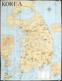
1960rif. 207712Seoul Korea.: Ministry of Transportation Republic of Korea. circa1960. Folding colour pictographic / pictorial map inset maps of Seoul Chejudo Mt. Sorak Kyongju Pusan and map showing air routes to various Asian cities and to the California coast 67.5 x 51 cms; 22.5 x 10 cms folded small fold tear without loss index and five distance tables printed on the verso in very good condition. Uncommon pictorial map of the Korean Peninsula showing wildlife natural wonders numerous temples hotsprings seaports and railways many sights designated "National Treasures". Printed for the tourist market one of the inset maps shows the flight routes from key Southeast Asian ports to Seattle and San Francisco. . Ministry of Transportation Republic of Korea. unknown
rif. DADAX041517886XNew unknown
rif. SONG303004467XSpringer 2018-12-10. 1st ed. 2019. hardcover. Used: Good. 6.14x0.54x9.21. Buy with confidence. Excellent Customer Service & Return policy. Springer hardcover
1993rif. x-9810215290World Scientific Pub Co Inc 1993. Hardcover. New. 432 pages. 9.00x6.25x1.00 inches. World Scientific Pub Co Inc hardcover
rif. 0851241875New. paperback. New. Satisfaction Guaranteed or your money back. paperback
rif. 37501One page of text in Japanese and English. 105 plates on 45 pages many in color. 1 vols. Small Folio. Loose in cloth portfolio. Minor wear to portfolio plates fine. One page of text in Japanese and English. 105 plates on 45 pages many in color. 1 vols. Small Folio. unknown
1873rif. 168911873. Original Map Asia: China Korea Thailand India Taiwan Malaisia Kuwait Arabia 1873 With The Title "Asia" in the left corner. Origin of the Map is from the "Stieler's Hand-Atlas." continent-based upon von Stulpnagel published in Gotha by Justus Perthes. Germany. Beautifully Hand Colored. Date of issue: 1873. Size: The sheet measures aprox 18 in x 15 in or 45 x 37 cm. Overall very good condition. unknown