2.138 Ergebnisse
Best.-Nr. 7461Two parts in one vol. Small folio orig. wrappers somewhat tired & a little soiled some light staining & soiling here & there manuscript title on upper cover later stitching. Hansong Seoul: Kyujanggak the Royal Library Preface dated 1793 & 1796. First edition of this handsome and large-format 323 x 217 mm. royal publication. King Chongjo 1752-1800 was one of the most intellectual and enlightened of the Korean monarchs. Perhaps Korea’s greatest bibliophile as royal patron he supported all aspects of the book: typographers printers authors librarians and lexicographers. A number of “royal” editions were published under his auspices. He founded the Kyujanggak Library in 1776 now part of the library of the Seoul National University. “The official rhyming dictionary of Chinese characters compiled under the supervision of King Chongjo and engraved in 1796. The arrangement is different from the usual Korean system in that instead of three rows of characters in the same rhyme there are four rows with the ipsÅng characters distributed in the bottom row” Fang The Asami Library 12.3. The main compiler of this work was the reformer Tong-mu Yi 1741-93 who had travelled to China and was an important member of the Northern Learning School. This group of intellectuals recognized the practical benefits of commerce and technology and urged the modernization of Korean society. Yi was appointed by King ChÅngjo as one of the famed four editors of the Royal Library overseeing the publication of books. A very nice copy. References Fang Chaoying. The Asami Library: A Descriptive Catalog. Edited by Elizabeth Huff. Berkeley: University of California Press 1969. unknown books
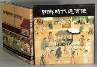
1986Best.-Nr. 65283Seoul: Sanhe Publishing 1986. Square 4to pp. 155 1; text in Korean; color text illustrations throughout; full green cloth gilt title on spine; fine in fine dust jacket and slipcase. During the Joseon Choson period the government sent a number of envoys to Japan for diplomatic missions. Those missions were met with intense curiosity by the local Japanese and became the subjects of many works from paintings to popular prints. Sanhe Publishing unknown
1986Best.-Nr. 65283Seoul: Sanhe Publishing 1986. Square 4to pp. 155 1; text in Korean; color text illustrations throughout; full green cloth gilt title on spine; fine in fine dust jacket and slipcase. During the Joseon Choson period the government sent a number of envoys to Japan for diplomatic missions. Those missions were met with intense curiosity by the local Japanese and became the subjects of many works from paintings to popular prints. Sanhe Publishing unknown books
2006Best.-Nr. 64115KyÅnggi-do P'aju-si: An Gŭrap'iksŭ 2006. Large 8vo pp. 260; illustrated throughout mostly in color; fine copy in original red cloth and publisher's slipcase. Parallel text in English and Korean. Korean treasures from the Paleolithic Age to the 19th century including furniture ceramics textiles paintings manuscripts etc. An Gŭrap'iksŭ unknown books
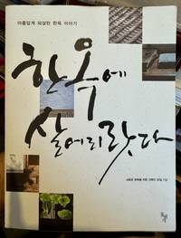
2007Best.-Nr. 106704ê²½ê¸°ë„ 파주시 : ëŒë² ê°œ 2007. ì´ˆíŒ. Paperback. Fine. 387 pages: illustrations chiefly color; 25 cm. Includes index. In Korean. Heavily illustrated; color plates line drawings b&w photos etc Extremely well done. Korean Architecture Domestic -- Korea South -- Designs and plans. Vernacular architecture -- Korea. Architecture domestique -- Corée du Sud. Architecture domestique -- Corée du Sud -- Dessins et plans. Architecture vernaculaire -- Corée. Architecture Domestic. Vernacular architecture. Hanguk ëŒë² ê°œ paperback
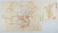
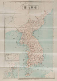
1902Best.-Nr. 220266Japan. No date. Circa1902. Two very attractive colour folded manuscript maps one showing China and the other Korea. Map of China: Watercolour map 48 x 63.5cm. Closed tear now professionally repaired. Map of Korea: Finely detailed watercolour map a few tiny holes very neatly repaired on the verso with archival washi. 33 x 24.5cm Two delicate hand-painted maps one of China and one of Korea produced by a Japanese student cartographer named Koike Tokushige 小池徳重. The undated map of China appears to have been produced in the first five years of the twentieth century: a time when Japan had recently colonized Taiwan and when Japanese economic and political interest in the region was rapidly expanding. The inscription on the map suggests that it was a third year college project. But the high level of detail suggests that the artist had considerable experience of map making. The map of China shows the main provinces rivers major transport routes the Great Wall and the location of key cities although the names of the cities are not included. It also shows outlines of the Korean Peninsula Taiwan and the Japanese island of Kyushu but not the rest of Japan. The map of Korea is more detailed. It provides an accurate outline of the Korean Peninsula with careful hatching indicating changes in elevation. Rivers and major road routes are shown on the map and the locations of major towns are marked though only Busan and Incheon are named. Dotted lines show coastal sea routes and routes between Kyushu and Busan and between Incheon and China. The map shows the Gyeongin railway line between Seoul and Incheon which was completed in 1899 and route of the Gyeongbu railway line between Busan and Seoul whose construction started from both ends in 1901. But the map depicts only small sections of this line close to Seoul and Busan as being completed with the rest more lightly outlined to show the projected route implying that the map was drawn around 1901-1902 and certainly before the Gyongbu line was opened in 1904. Inserted text gives the land area and population of Korea. Rather strangely though the figure given for the Korean population is vastly underestimated. Ikeda gives this as 5.7 million when in fact at that time is was around 18 million. . unknown
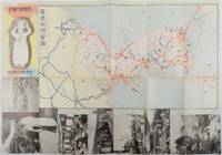
1937Best.-Nr. 178598Korea.: 朝鮮総督府鉄道局. Chosen Sotokufu Tetsudokyoku. Showa 12 1937. Folded travel brochure featuring a large colour map of Korea black and white photographic illustrations 53 x 38 cm folded. Small holes and a little worn along folds a good copy. 18.2 x 9 cm. Attractive folding map and travel guide to Korea produced by the colonial government's Railway Bureau. The cover illustration shows a Korean woman carrying a water jug on her head. The map shows the Korean Peninsula with main towns. The map is surrounded by a set of black-and-white photos of landmarks including a cityscape of Seoul and a flock of sheep in northern Korea. The photos are set in a design showing Korean figures in traditional costume. The text on the reverse of the map provides information including various railway lines in the country and possible itineraries to cover major sites. There is also a more detailed explanation of the sights to be seen along five major rail routes: from Busan to Seoul Keijo; from Seoul to Andong; from Daejeon to Mokpo from Seoul to Wonsan and from Wonsan to Hoeryong. . 朝鮮総督府鉄道局. [Chosen Sotokufu Tetsudokyoku]. unknown
1927Best.-Nr. 159846Keijo.: 朝鮮総督府 Office of Governor-General of Korea. Reprint. Showa 2 1927. Japanese language travel brochure for Korea single folded sheet with colour map of Korea Scale 1:2500000 on one side attractive colour cover and descriptive text with black and white photographic illustrations in 12 panels on the reverse. Map includes a small inset map of East Asia. Measures 53.8 x 38.4cm folded 9.6 x 19.5cm. This travel brochure was published in Korea by the Office of Governor-General of Korea in 1927 with the aim of attracting Japanese visitors to Korea. The text describes Korea's geography weather and transportation; major cities such as Busan and Seoul; and industry including agriculture commerce and manufacturing. Accompanying photos are those of Seoul Kunsan Port a ginseng field Moran Fortress in Pyongyang and Mt. Kumgang. . 朝鮮総督府 [Office of Governor-General of Korea]. unknown
1981Best.-Nr. 117243Tokyo Kyuryudo 1981 1 vol. relié in-folio, demi-toile de l'éditeur, étui, 237 pp., nombreux plans en noir et photographies en noir et en couleurs par Osamu Murai. Textes japonais avec leur traduction anglaise. Dessin au feutre sur la page de garde. Sinon très bon exemplaire.
1981Best.-Nr. 117243Tokyo Kyuryudo 1981 1 vol. relié in-folio, demi-toile de l'éditeur, étui, 237 pp., nombreux plans en noir et photographies en noir et en couleurs par Osamu Murai. Textes japonais avec leur traduction anglaise. Dessin au feutre sur la page de garde. Sinon très bon exemplaire.
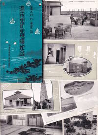
1920Best.-Nr. 223564Japan.: 海雲台温泉合資会社. Kaiundai Onsen Goshi Kaisha. Circa 1920's. Eight black and white postcards presented in a paper folder. The cards are all in very good condition the paper folder is worn with two small punch holes along upper edge a sellotape stain long lower edge. Very good. A set of eight black and white postcards of Haeundae Hot Spring Resort near Busan South Korea produced in the colonial era probably 1920s and published in Japan. The postcards are contained in a decorative sleeve and show the modern buildings of the hot spring resort the surrounding coastal landscape and interior shots of the Japanese style rooms and the big hot spring tubs with women and children enjoying their baths. The postcards were produced at a time when the Japanese government was enthusiastically encouraging Japanese tourism to the colony of Korea and this spa resort probably run by Japanese owners appears to be part of the growing network of Japanese tourist sites in Korea Taiwan and later Manchuria. . 海雲台温泉合資会社. [Kaiundai Onsen Goshi Kaisha]. unknown
2006Best.-Nr. 64115KyÅnggi-do P'aju-si: An Gŭrap'iksŭ 2006. Large 8vo pp. 260; illustrated throughout mostly in color; fine copy in original red cloth and publisher's slipcase. Parallel text in English and Korean. Korean treasures from the Paleolithic Age to the 19th century including furniture ceramics textiles paintings manuscripts etc. An Gŭrap'iksŭ unknown
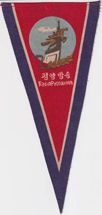
1960Best.-Nr. 219665No publication details. circa1960s –70s based on design and material. Printed fabric pennant promoting Radio Pyongyang North Korea’s official broadcasting service. The image shows a stylised monument of two figures possibly symbolising industry and broadcasting with a laurel motif and radio waves under a red sky. Text in both Korean and English. Radio Pyongyang. “평양 방송” translates directly as Pyongyang Broadcasting. Text in Korean and English. 23.5 height x 11cm at top edge. A scarce example of early North Korean visual propaganda. Radio Pyongyang was founded in October 1945 and inaugurated programming with a live broadcast of Kim Il Sung's victory speech when he returned to Pyongyang at the end of WWII. The image on this pennant features a statue of two figures a worker and a peasant woman carrying a sheaf of rice riding the mythical horse Chollima symbolising speed strength and the spirit of the North Korean people. The Chollima movement which began in 1956 encouraged citizens to achieve extraordinary production and labour targets indicated by the sheaf of wheat symbolic of agricultural abundance. Radio Pyongyang helped to disseminaate the ideals of the Chollima movement and this pennant probably dates from after the Chollima Monument was unveiled in 1961. Provenance: Bought in China by a western collector in the late 20th century. . No publication details. unknown