Young J (Korea University) MoonBiblio.com
Introduction to Fluid Dynamics
réf. ria9781119823155_inpHardback. New. New Book; Fast Shipping from UK; Not signed; Not First Edition; N/A hardcover

Ria Christie Collections · Royaume-Uni122,18 £GB≈ 146,53 €
763 résultats
1992réf. 2091502133903012Kokusho Publishing Association 1992. Soft Cover. Fine. Volume: 1 Kokusho Publishing Association paperback
2001réf. 2092902137602019Akashishoten 2001. Soft Cover. Fine. Number of pages: 430p Size: A5 cover band 21cm Number of books: 1 Akashishoten paperback
réf. ria9781119823155_inpHardback. New. New Book; Fast Shipping from UK; Not signed; Not First Edition; N/A hardcover
1974réf. 2091502135413940Gen iwa-sha 1974. Soft Cover. Fine. Number of books: 1 Gen iwa-sha paperback
1992réf. 2090202120404845Shinkansha 1992. Soft Cover. Fine. Number of books: 1 Shinkansha paperback
1992réf. 2091502133904878Shinkansha 1992. Soft Cover. Fine. Volume: 1 Shinkansha paperback
1992réf. 2091502135404577Shinkansha 1992. Soft Cover. Fine. Number of books: 1 Shinkansha paperback
1851réf. 200120AG1851. London Edinburgh & Dublin J.& F. Tallis 1851. Original steel engraving / Vintage map. Drawn and engraved by John Rapkin. Partly hand-coloured. Illustrations by H. Warren and Enrgaved by J.H. Kernot. Plate Size: 33 cm x 25.5 cm. Sheet Size: 37.4 cm x 27.3 cm. Vintage 19th century map in very good condition. Published in the Illustrated Atlas And Modern History Of The World Geographical Political Commercial & Statistical Edited By R. Montgomery Martin. Beautifully bordered and fascinating map of Japan and Korea. The names of the major islands of Japan - Kiosiou Sitkokfi Shikoku and Niphon Honshu and the southern tip of 'Matsmai or Yersqi' Hokkaido are included on the map. Below the elbow of Honshu can be seen the tiny island of Fatsisio - the 'place of exile for the Grandees of Japan.' The map's nomenclature is interesting: Tokyo not yet the capital is named as Yedo while the then-capital Kyoto appears as 'Meaco'. Across the Korean Strait modern Seoul appears as 'Han y'. As these maps were being published both of these ancient and distinctive states Korea - the 'Hermit Kingdom' - and Japan - isolated under the centuries' long under the sakoku policy - were having to acclimate to increased Western influence in their region. The 1853-54 U.S. diplomatic and military naval expedition under Commodore Perry would force the establishment of diplomatic relations between Japan and the western "Great Powers" and eventually to the collapse of the ruling Tokugawa shogunate and the Meiji Restoration. Japan would partially embrace the West and western influences and emerge as a burgeoning regional power eventually establishing control over Korea by the early 20th century - at the beginning a calamitous half-century for the region. John Tallis 7 November 1817 3 June 1876 was an English cartographic publisher. His company John Tallis and Company published views maps and atlases in London from roughly 1838 to 1851. Tallis set up as a publisher with Frederick Tallis in Cripplegate in 1842; the business moved to Smithfield in 1846 and was dissolved in 1849. From 1851 to 1854 Tallis operated as John Tallis and Company. He started The illustrated news of the world and national portrait gallery of eminent personages in 1858 selling it for £1370 in 1861; it folded in 1863. Wikipedia The most important project John Tallis undertook was the 'Illustrated Atlas' from 1851. The original map we offer here was part of this exceptional Atlas and all the maps it contained are still today considered as the last reminder of an era of lavish map production. Tallis worked the project together with John Rapkin 1815-1876 and it was Rapkin's style and talent that we have to thank for when we marvel at these maps today. What makes these maps so special is the detail of engraved vignettes that surround the map and often show indigenous scenes people in their environment and even more so historical buildings or historical views of towns and cities architecture and landscape. The project of 'The Illustrated Atlas' was designed to be finished just in time for the anxiously awaited "Great Exhibition of the Works of Industry of All Nations" or The Great Exhibition sometimes referred to as the Crystal Palace Exhibition in reference to the temporary structure in which it was held was an international exhibition that took place in Hyde Park London from 1 May to 11 October 1851. It was the first in a series of World's Fairs exhibitions of culture and industry that became popular in the 19th century and it was a much-anticipated event. The Great Exhibition was organized by Henry Cole and Prince Albert husband of the reigning monarch Queen Victoria. It was attended by numerous notable figures of the time including Charles Darwin Samuel Colt members of the Orléanist Royal Family and the writers Charlotte Brontë Charles Dickens Lewis Carroll George Eliot and Alfred Tennyson. Music for the opening was under the direction of Sir George Thomas Smart and the continuous music from the exhibited organs for the Queen's procession was "under the superintendence of William Sterndale Bennett". Wikipedia unknown
1925réf. 64345Tokyo Japan: Japanese Government Railways; Chosen Government Railways; South Manchuria Railway Company et al. Toppan Printing Co. 1925. Oblong 4to. 8.6 x 8 in. 2 72 18 columns i.e. 46 pp. printed in double columns throughout although some ads are double-column size and in red & black decorative red borders. With text illustrations & diagrams in red 4 colour maps 1 4-column or double-page. photo illustrations throughout. Self-printed colour-illustrated softcovers front cover art of Mt. Fuji by Hokusai colour map back cover for the N.Y.K. & O.S.K. Steamship lines slight dustsoiling very faint tidemark at foot of spine slight edgewear still a VG bright copy. First edition of this combination land promotion and travel brochure later available at the Japanese pavilion in the ill-fated 1926 Sesquicentennial International Exposition held in Philadelphia PA. Potential Asia travelers are supplied with travel information steamship instructions details on the Railways including the J.G.R. places to visit in Taiwan Formosa; cities sites and experiences in Korea along the Chosen Government Railway line as well as travel through Japanese-controlled Manchuria China during the Roaring 20’s. Worldcat locates 1 copy U of DE. [Japanese Government Railways; Chosen Government Railways; South Manchuria Railway Company, et al. (Toppan Printing Co.)], paperback
2002réf. 2091502135415179Not Available 2002. Soft Cover. Fine. Number of books: 6 Not Available paperback
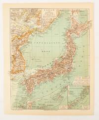
1902réf. 174898Leipzig.: Bibliographisches Institut. 1902-1908. Map printed in colour 27.2 x 21.4 cm inset colour key to territorial administration by country inset "western continuation of the main chart" including the Gulf of Tschili and Tsientsin and two insets at the foot of the map to the Kuril and the Ryuku Islands text in Geman central fold slight edge toning but in very good condition. Attractive map text in German prepared for Meyers Großes Konversations-Lexikon. . Bibliographisches Institut unknown
1997réf. 2080302106809263Akashishoten 1997. Soft Cover. Fine. The book is in fine condition. Akashishoten paperback
2017réf. 2091502135419235Not Available 2017. Soft Cover. Fine. Number of books: 1 Not Available paperback
2002réf. 2091502135416745Not Available 2002. Soft Cover. Fine. Number of books: 1 Not Available paperback
1971réf. 2091502135406755Toa shubbansha 1971. Soft Cover. Fine. Number of books: 1 Toa shubbansha paperback
1983réf. 2091502135403625educational book publisher 1983. Soft Cover. Fine. Number of books: 1 educational book publisher paperback
1983réf. 2091502135417784Not Available 1983. Soft Cover. Fine. Number of books: 1 Not Available paperback
1987réf. 2091202133212230Not Available 1987. Soft Cover. Fine. Volume: 1 Not Available paperback
1991réf. 2091202133208950Not Available 1991. Soft Cover. Fine. Volume: 1 Not Available paperback
1986réf. 2091202133212345Sanwa Publishing Company special city 1986. Soft Cover. Fine. Volume: 1 Sanwa Publishing Company (special city) paperback
2009réf. 2092902143401520Not Available 2009. Soft Cover. Fine. Size: 27.8x28 Number of books: 3 books in total Not Available paperback
réf. 2080202103704614Nanposhinsha N.A. Soft Cover. Fine. Page number: 161p Size: 19cm B6 Nanposhinsha paperback
1941réf. 2081002108301684Not Available 1941. Soft Cover. Fine. Number of books: 1 Not Available paperback
2002réf. 2091502135412050Not Available 2002. Soft Cover. Fine. Number of books: 1 Not Available paperback
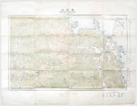
1917réf. 167697Tokyo: Rikuchi Sokuryobu 1917. First edition first printing of this bilingual tourist map of Mount Kumgang produced by the nascent Japanese colonial administration in Korea. In the 1910s politicized textbooks for Korean students singled out Fuji and Kumgang as the largest mountains in Japan and Korea while always stressing Fuji's status as the tallest. We have traced a single institutional copy at the National Diet Library. Kumgang was a popular destination for western travellers and naturalists. In 1917 the areas was visited by the legendary plant-hunter E. H. Wilson who discovered two species of maple as well as several new taxa on its slopes. In his notes he wrote how the mountain "drives a photographer to despair for no sooner has he taken one superb view than another seemingly more superb presents itself" quoted by Arnold Arboretum. Colour lithographed map 630 x 820 mm folding away to 209 x 110 mm as issued. Text in Japanese and English. Several contemporary ink circles and annotations. A few small splits along folds not affecting map area old brown paperclip mark a little creasing and soiling. A very good bright example. "1917-1919: Expedition to Eastern Asia" Arnold Arboretum available online. unknown