Joseph-Francois Lafitau (1681-1746)Biblio.com
1 758 résultats
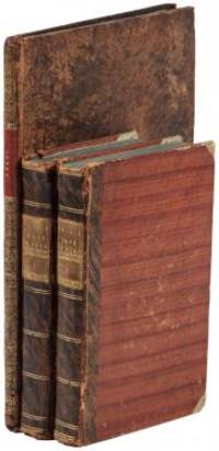
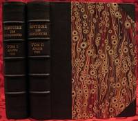
1733réf. E05532 volumes. 8xxiv616471 pages with 4 maps ad view one folding and 3 plates one folding; 2693892 pages with 1 map and 6 plates. Quarto 10 1/4" x 10 1/4" bound in half leather with raised spine bands and gilt lettering to spine over marbled boards. Borba de Moraes page I:453; European Americana 733/146; Sabin 38591 First edition. Joseph-François Lafitau was a French Jesuit missionary ethnologist and naturalist. He is best known for his use of the comparative method in the field of scientific anthropology the discovery of ginseng and his writings on the Iroquois. Lafitau was the first of the Jesuit missionaries in Canada to have a scientific point of view. Lafitau is considered the first of the modern ethnographers and a precursor of scientific ethnology for his work on the Iroquois. He developed a model of studying peoples that involved describing existing cultures on their own terms—not in comparison to European society. He distinguished generic and specific traits transforming the "generic savage" into specific tribal groups. He explained that "only from specific identities can genetic relations be inferred." Furthermore he was the first to declare "contemporary primitive cultures throw light upon the culture of ancient people and vice versa. Lafitau is remembered for applying the comparative method with a greater level of competency than any of his contemporaries. Through original field observations he was able to critique the works of earlier writers on Primitive peoples. By using the Comparative Method Lafitau rejected all theories of social and cultural change and instead used his study to demonstrate the similarities in customs practices and usages of the Native North Americans with diverse peoples from different continents and centuries. He consistently relied on the doctrine of degeneration: all men originally shared one religion with one God but over time as people migrated to separate margins of the earth where they then lost touch with the values and traditions of this one true religion and culture. Therefore Lafitau believed in the "psychic unity of mankind" and the doctrine of primitive monotheism. His major work written in French was first published in 1724 in Paris. It is entitled Customs of the American Indians Compared with the Customs of Primitive Times Moeurs des Sauvages Amériquains Comparées aux Moeurs des Premiers Temps and is 1100 pages in total. In 1974 William Fenton and Elizabeth Moore made the first translation into English available. Lafitau published two other works. One Histoire de Jean de Brienne Roy de Jérusalem et Empereur de Constantinople Paris 1727 was released before he returned to Canada; it is little known and seldom seen. A two-volume Histoire des découvertes et conquestes des Portugais dons le Nouveau Monde . . . 1733 appeared after he came home to France. Frequently found in libraries it is not just a compilation of original sources but an attempt to make available to French readers a story of exploration and adventure otherwise denied to them; in the chronicles he sees a long development of customs hitherto unnoticed such as he had reported in the Mœurs; from them understood only he says in the original languages of the people who practice them he builds his "system" or philosophy of history and once more he is concerned too with the relation between custom and natural history or ecology. Condition: Beautifully rebound in half leather. Faint dampening to second volume; early owner's signatures on title pages inked stamps of St Charles Borromeo Seminary on front paste-downs and first title page lacks frontispiece else a very good to fine set. Chez Saugrain pere, quai des Augustins, au coin de la rue Chez Saugrain pere, quai des Augustins, au coin de la rue Pavee, a la hardcover
réf. 0484463985.Ghardcover. Good. Access codes and supplements are not guaranteed with used items. May be an ex-library book. hardcover
1802réf. E01512 volumes with Atlas. 4xxiv385 pages with xxii-xxiv lists books of voyages available from the publisher; 4418 pages with appendix containing vocabularies of the languages of Yukagir Yakut Tungoose Kamchatka the Aleutian Islands and Kadiak and inex. Atlas with title list of plates 14 engraved plates & large folding engraved map. Text volumes are small octavo 7¾" x 4½" 19th century quarter calf & boards spines tooled in gilt morocco lettering pieces; atlas is quarto 11" x 7½" in period tree calf spine tooled in gilt. Translated by J Castéra. Howes S-117 First French Edition. Martin Sauer was an English civil servant who knew Russian French and German. He became acquainted with Joseph Billings in St Petersburg in the 1780s. He agreed to join Billings expedition as his secretary and interpreter. It was agreed that he would write the official account but there is some controversy about his actives when he returned to St Petersburg in 1794. It has been suggested that he left hurriedly for England with much of the important archival material from the voyage including diaries and secret reports so that he could publish a record of the expedition before Russian authorities and scholars in the Academy of Sciences could review its details. Sauer's An account of the Geographical and Astronomical Expedition to the Northern Parts of Russia was published in London in 1802. It contains an abundance of detail about eastern Siberia and the Aleutian Islands and records the expeditions visits to Kodiak Island Prince William Sound and the coast south as far as Yakutat Bay. The chart was made by Aaron Arrowsmith from Sauer's notes and Billings observations and the whole complements well the other contemporary accounts of the expedition by the cartographer Gavriil Sarychev and the naturalist Carl Heinrich Merck. Aaron Arrowsmith 1750–1823 was an English cartographer engraver and publisher and founding member of the Arrowsmith family of geographers. He moved to Soho Square London from Winston County Durham when about twenty years of age and was employed by John Cary the engraver and William Faden. He became Hydrographer to the Prince of Wales ca. 1810 and subsequently to the King in 1820. In January 1790 he made himself famous by his large chart of the world on Mercator projection. Four years later he published another large map of the world on the globular projection with a companion volume of explanation. Condition: Some rubbing and wear to coves of both atlas and text volumes some chipping to spine ends small gouge at back of atlas and stamp to front end paper else in very good condition. Chez F Buisson hardcover
1979réf. KOS02900018Kodansha 1979. Soft Cover. Fine. KOS02900018 Kodansha paperback
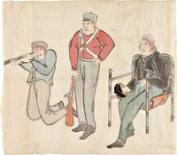
1853réf. 34749Edo 1853. Watercolour and ink drawing on Japanese paper. A contemporary Japanese watercolour of Commodore Perry and members of his expedition produced at the moment of the American squadron’s arrival in Japan and the opening of sustained diplomatic contact between Japan and the United States. This lively drawing belongs to the immediate visual culture generated by Commodore Matthew C. Perry's arrival in Japan in 1853. Perry entered Edo Bay in July 1853 to deliver President Fillmore's request for a treaty and returned the following year leading to the Treaty of Kanagawa on 31 March 1854. The event prompted wide Japanese interest in the appearance dress equipment and conduct of the visiting Americans and images of the "Black Ships" and their crews circulated in manuscript painted and printed form. The composition presents three American figures isolated against the paper ground arranged almost as a study of types. At right Commodore Perry is shown seated in a chair wearing a dark naval coat and holding his hat. At center stands an armed crewman or marine in a red jacket holding a musket upright; at left another crewman kneels while looking through a telescope or spyglass. The emphasis falls on uniform posture weaponry and optical instrument details that would have marked the Americans as visually and technologically unfamiliar to Japanese observers. The drawing is especially interesting as a Japanese interpretation of the expedition distinct from the official American pictorial record produced by artists such as Wilhelm Heine. The Japanese manuscript images such as the present work preserve a different perspective shaped by local observation report and curiosity. unknown
réf. 51527040like new. unknown
réf. 1331951879.Gpaperback. Good. Access codes and supplements are not guaranteed with used items. May be an ex-library book. paperback
réf. 1334451192.Gpaperback. Good. Access codes and supplements are not guaranteed with used items. May be an ex-library book. paperback
1904réf. 34773Edinburgh: T. & T. Clark 1904. First Edition. profusely illustrated with 33 black and white illustrations on glossy plates including a map and city plan and with a fold out map of the Mounds of Nippur. 8vo publisher's original buff decorated cloth the upper cover with a portrait of a Hillah workman in buff red black and white within a black border with black lettering the spine gilt lettered and ruled in black with small Sumerian bird symbol in red top edge gilt. xii 355 pp. A fine copy the text-block perfectly clean and fresh slight mellowing to prelims and fore-edge only the binding very sound and fresh with just a tiny bit of age evidence a beautiful copy. FIRST EDITION AND A POPULAR ACCOUNT OF THE IMPORTANT BABYLONIAN EXPEDITION OF THE UNIVERSITY OF PENNSYLVANIA. The author was the only English member of the American expedition giving him a unique perspective on its intentions and discoveries. BY NILE AND EUPHRATES is not a typical expedition log; it is an account of life in an excavator's camp the journey to camp and the people encountered along the way. As British member of Petrie's archeological expedition to Egypt and Mesopotamia Geere was present during the important excavations at Nippur. Nippur was situated on both sides of the ancient bed of the Shatt-en-Nil canal one of the earliest courses of the Euphrates between the present bed of that river and the Tigris almost 160 km southeast of Baghdad. The canal bed divides the site into an East Mound and West Mound. It is represented by the great complex of ruin mounds known to the Arabs as Nuffar written by the earlier explorers Niffer and later as Nippur. Nippur was first excavated briefly by Sir Austen Henry Layard in 1851. But full-scale digging was begun by the expedition from the University of Pennsylvania. The work involved four seasons of excavation between 1889 and 1900 and was led by John Punnett Peters John Henry Haynes and Hermann Volrath Hilprecht all of whom were known to and cited by Geere. Thousands of tablets were found at a smaller mound dubbed "tablet hill" about 7.5 meters in average height and 52 square meters in area southeast of the temple mound.A true arch one of the world's earliest examples was also found. In the Parthian layer a box containing fragments of votive axes made of glass from the Kassite period were found. Several late Kassite rulers are represented including Kurigalzu II. T. & T. Clark hardcover
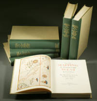
1957réf. E0551From the Spanish discovery to the opening of the Civil War 5 volumes in 6. Volume One: The Spanish Entrada to the Louisiana Purchase 1540-1804 xiv264 pages with color frontispiece map and 275 maps many folding and index; Volume Two: From Lewis and Clark to Fremont 1804-1845 xiii281 pages with colored frontispiece map 143 additional maps some folding and index. Volume Three: From the Mexican War to the Boundary Surveys 1846-1854 xiii349 pages with colored frontispiece map 322 additional maps and index; Volume Four: From the Pacific Railroad Surveys to the Onset of the Civil War 1855-1860 xiii260 pages with color frontispiece map an additional 127 maps some folding and index; Volume Five From the Civil War to the Geological Survey Part One: xviii222 pages with color frontispiece map and an additional 152 maps; Volume Five From the Civil War to the Geological Survey Part Two: 223-487 pages with 124 maps and index. Folio 14 1/2" x 10 1/2" bound in quarter green leather with gilt lettering to spines. volume I printed by the Grabhorn Press; volumes II-V printed by Taylor & Taylor and James Printing based on the designs of Edwin and Robert Grabhorn. First edition limited to 1000 copies. Carl Wheat's Mapping of the Trans-Mississippi West is a comprehensive and readable cartographic history of the American West. The first three volumes of the work are by necessity bulky and out sized to accommodate the many maps contained with their covers. These beautifully printed books present a truly graphic picture of the exploration and peopling of the vast unknown land west of the Mississippi. The author does not merely present a catalog of significant maps of each era but tells the exciting story of many facets of history that resulted in their making-of the hard journeys the hazardous exploits the motivation the mysticism the misunderstandings and the strange blend of fact imagination false geographic concept and political necessity which were consummated in the engraver's work. These volumes will provide exciting text for the casual reader and have become eminent source book for the student and scholar. Condition: A near fine set. Due to the size and/or weight of this lot extra shipping and/or handling charges may apply. Institute of Historical Cartography hardcover
réf. 048434191X.Ghardcover. Good. Access codes and supplements are not guaranteed with used items. May be an ex-library book. hardcover
réf. 0656491183.Ghardcover. Good. Access codes and supplements are not guaranteed with used items. May be an ex-library book. hardcover
réf. 0483698962.Ghardcover. Good. Access codes and supplements are not guaranteed with used items. May be an ex-library book. hardcover
réf. 0656067071.Ghardcover. Good. Access codes and supplements are not guaranteed with used items. May be an ex-library book. hardcover
réf. 0656013095.Ghardcover. Good. Access codes and supplements are not guaranteed with used items. May be an ex-library book. hardcover
réf. 0666812748.Ghardcover. Good. Access codes and supplements are not guaranteed with used items. May be an ex-library book. hardcover
réf. 1391453921.Ghardcover. Good. Access codes and supplements are not guaranteed with used items. May be an ex-library book. hardcover
réf. 0365358797.Ghardcover. Good. Access codes and supplements are not guaranteed with used items. May be an ex-library book. hardcover
réf. 0365833045.Gpaperback. Good. Access codes and supplements are not guaranteed with used items. May be an ex-library book. paperback
réf. 0332935930.Ghardcover. Good. Access codes and supplements are not guaranteed with used items. May be an ex-library book. hardcover
réf. 0265919568.Ghardcover. Good. Access codes and supplements are not guaranteed with used items. May be an ex-library book. hardcover
réf. 0266173373.Ghardcover. Good. Access codes and supplements are not guaranteed with used items. May be an ex-library book. hardcover
réf. 0282270086.Gpaperback. Good. Access codes and supplements are not guaranteed with used items. May be an ex-library book. paperback
réf. 0365218367.Ghardcover. Good. Access codes and supplements are not guaranteed with used items. May be an ex-library book. hardcover
réf. 0267485026.Ghardcover. Good. Access codes and supplements are not guaranteed with used items. May be an ex-library book. hardcover