3 690 résultats
réf. DADAX0600036383New unknown
réf. DADAX1138904279New unknown
réf. DADAX0861546326New unknown
réf. DADAX0548895791New unknown
réf. DADAX0275922154New unknown
réf. DADAX1575060701New unknown
réf. DADAX1847252486New unknown
réf. DADAX0399123989New unknown
réf. DADAX0367542196New unknown
réf. DADAX0567129845New unknown
réf. DADAX0804753652New unknown
réf. DADAX0025111302New unknown
réf. DADAX0548313245New unknown
réf. DADAX1446031918New unknown
réf. DADAX3110288060New unknown
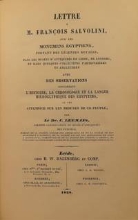
1838réf. 51161 Dr. Conradus Leemans Lettre a M. Francois Salvolini sur les Monumens Egyptiens portant des legendes royales dans musees d'antiquites de leide de londres et dans quelques collections particulieres en angleterre 1838. Chez H. W. Hazenberg et Comp. Leide. 160 pp. XXXII 32 plates 2 Palestine Exploration Society No. 2 Second Statement September 1873 Hackensack N.J. 76 pp. vi 3 Henrico Brugsch De Natura et Indole Linguae Popularis Aegyptiorum. Fasciculus prior de Nomine de Dialectis de Litterarum Sonis 1850. Prostat in Libraria Dummleriana Berolini. 40 pp. 4 Dr. Heinrich Brugsch Die Adonisklage und das Linoslied 1852. Ferd. Dummler's Verlagsbuchhandlung Berlin. 33 pp. 5 Heinrich Hubschmann Die Umschreibung der Iranischen Sprachen un des Armenischen 1882. Druck und Verlag von Breitkopf und Hartel Leipzig. 44 pp. 6 Dr. Martin Haug Das achtzehnte Kapitel des Wendidad ubersetzt und erklart 1869. F. Straub Munchen. 54 pp. 7 Dr. Richard Lepsius Das Allgemeine Linguistische Alphabet. Grundsatze der ubertragung fremder schriftsysteme und bisher noch ungeschriebener sprachen in Europaische Buchstaben 1855. Wilhelm Hertz Berlin. 64 pp. Majority are first editions. Text in French English German and Latin. Quarter cloth over marbled boards. 4 fold-out reproductions of Egyptian tablets and/or hieroglyphs; 4th fold-out has a large tear at first interior fold still intact p. 76 of Palestine Exploration Society. 1 fold-out illustration. Some occasional spotting throughout. Loss to cloth of spine and rubbing to exterior edges of covers. 160 pp. XXXII 32 plates; 76 pp. vi; 40 pp.; 33 pp.; 44 pp.; 54 pp.; 64 pp.; ~503 pp. total. 6 x 8 1/2 inches. Chez H. W. Hazenberg et Comp.; Hackensack; Prostat in Libraria Dummleriana; Breitkopf und Hartel; F. Straub; Wilhelm Hertz hardcover
2015Mm 140x210 Collana "I Robinson/Letture". Volume cartonato rigido di XI-426 pagine, sovraccoperta editoriale, timbro dell'editore in apertura. Libro in condizioni di nuovo. SPEDIZIONE IN 24 ORE DALLA CONFERMA DELL'ORDINE.
1762réf. 112506Luchtmans 1762 Lugduni Batavorum [Leyde], Samuelem et Joannem Luchtmans, 1762, 1 volume in-8 de 125 x 200 mm environ, LIV pages, (38) ff. (Dedicationes et Praefationes, Tetsimonia, Domino Valenti), 772 pages, (45) ff. (Index). Pleine reliure parchemin, dos lisse portant titres dorés sur pièce de cuir vert foncé, les deux plats comporte un estampage à la dorure armorié encadré d'une frise dorée à écoinçoins, traces de liens. Parchemin un peu sali avec un reste d'étiquette papier en queue de dos, mors interne supérieur fendu sans gravité (exemplaire solide), ex libris de Jean Varille collé sur le premier contreplat, pagination suspendue de la page 664 à 684 sans manque, une mouillure dans la marge d'une vingtaine de pages, intérieur propre pour le reste.
No Date (Mid 20th Century) . 1st edition. Large poster, ca. 42 x 67 cm. In Hebrew. Anti Zionist poster by the Neturei Karta (Ha-Eidah ha-Hareidit), group of ultra-orthodox, mainly in Jerusalem, who regard the establishment of a secular Jewish state in Erez Israel as a sin and a denial of God, and therefore do not recognize the State of Israel. Their name, which is Aramaic for "guardians of the City, " derives from a passage in the Jerusalem Talmud (Hag. 76: 3) stating that religious scholars are the guardians and defenders of the city. Neturei Karta broke away from Agudat Israel in 1935, when the latter attempted to restrain extremist demands for an independent ultra-Orthodox Jerusalem community completely separate from the rest of the Zionist community. The group first adopted the name Hevrat ha-Hayyim, after Rabbi Joseph Hayyim Sonnenfeld. It aimed at creating "a circle free from the influence of the contemporary spirit and its fallacious opinions, " and a condition of membership was "the education of sons and daughters in the traditional Jewish manner, without any change (girls' schools which teach Hebrew do not provide education in the traditional Jewish manner). " The last phrase alluded to Agudat Israel's Bet Ya'akov girls' schools, where the language of instruction is Hebrew. Large poster, age staining, creased and split on folds with archival repairs to the rear. Good Condition thus. (Zion2-3-1)
1758Original single-sheet map in copperplate engraving of fine quality. Overall size ca. 400 x 510 mm. Plate mark ca. 360 x 445 mm. Image size ca. 345 x 425 mm. With Inset Map, "Der Verdeelinge van Israels Land", measuring ca. 150 x 110 mm, presented by two, finely engraved cherubs. Engraved illustration, depicting Joshua's men about to embark on the entry into the Promised Land. Illustrated cartouche encloses engraved title and colophon. Fine, strong impression on heavy handmade paper with ample margins all round. First, original state, unaltered by later colouration. Preserved flat in acid-free, pH-balanced, buffered archival paper. In a very fine condition. - - First edition. Willem Albert Bachiene (1712-1783), Dutch clergyman, later a professor of geography and astronomy at the Illustere School, Maastricht. Well known cartographer. The 3-volume "Heilige geographie of aardrijkskundige beschryving van het Joodsche land, alsmede andere landen in de H. Schrift voorkomende," is considered among his most important works. It was published in Utrecht between 1763-1768, and included a suite of 12 fine geographical maps of the Holy Land and its neighbouring lands which Bachiene made during a period of ten years, the first in as early as 1758. The map offered herewith is taken from this suite. Other important cartographic works of the Holy Land by Bachiene were included in the so-called "Jehovah Bible" i.e. "De Gansche H. Schrift, Vervattende alle de regelmatige Boeken des Ouden en Nieuwen Testaments (.) Gods Gedenk-Naam Jehovah onvertaald gehouden" published in 1762 by N. Goetzee of Gorinchem, shortly before the present map first appeared in book form. Whereas other single-sheet maps by Bachiene are in relative abundance, the works from "Heilige geographie of aardrijkskundige beschryving van het Joodsche land" are very scarce, seldom found in any state, practically unavailable in their original, uncoloured state.
1757Original single-sheet map in copperplate engraving of fine quality. Overall size ca. 400 x 510 mm. Plate mark ca. 365 x 445 mm. Image size ca. 340 x 420 mm. Engraved illustration at lower right corner. Handsome illustrated cartouche encloses engraved title and colophon. Scale within illustrated frame. Fine, strong impression on heavy handmade paper with ample margins all round. First, original state, unaltered by later colouration. Preserved flat in acid-free, pH-balanced, buffered archival paper. In fine condition. (A touch of browning to centrefold.) ~ First edition. Willem Albert Bachiene (1712-1783), Dutch clergyman, later a professor of geography and astronomy at the Illustere School, Maastricht. Well known cartographer. The 3-volume "Heilige geographie of aardrijkskundige beschryving van het Joodsche land, alsmede andere landen in de H. Schrift voorkomende," is considered among his most important works. It was published in Utrecht between 1763-1768, and included a suite of 12 fine geographical maps of the Holy Land and its neighbouring lands which Bachiene made during a period of ten years, the first in as early as 1758. The map offered herewith is taken from this suite. Other important cartographic works of the Holy Land by Bachiene were included in the so-called "Jehovah Bible" i.e. "De Gansche H. Schrift, Vervattende alle de regelmatige Boeken des Ouden en Nieuwen Testaments (.) Gods Gedenk-Naam Jehovah onvertaald gehouden" published in 1762 by N. Goetzee of Gorinchem, shortly before the present map first appeared in book form. Whereas other single-sheet maps by Bachiene are in relative abundance, the works from "Heilige geographie of aardrijkskundige beschryving van het Joodsche land" are very scarce, seldom found in any state, practically unavailable in their original, uncoloured state.
Original single-sheet map in copperplate engraving of fine quality. Overall size ca. 400 x 510 mm. Plate mark ca. 350 x 445 mm. Image size ca. 325 x 410 mm. Incorporates a detailed Plan of the City of Jerusalem within a general, delicately illustrated topographical view of its environs. Plain cartouche encloses title and colophon. Fine, strong impression on heavy handmade paper with ample margins all round. First, original state, unaltered by later colouration. Preserved flat in acid-free, pH-balanced, buffered archival paper. In fine condition. (Single outer corner finger-soiled, well away from image and plate mark.) - - First edition. Willem Albert Bachiene (1712-1783), Dutch clergyman, later a professor of geography and astronomy at the Illustere School, Maastricht. Well known cartographer. The 3-volume "Heilige geographie of aardrijkskundige beschryving van het Joodsche land, alsmede andere landen in de H. Schrift voorkomende," is considered among his most important works. It was published in Utrecht between 1763-1768, and included a suite of 12 fine geographical maps of the Holy Land and its neighbouring lands which Bachiene made during a period of ten years, the first in as early as 1758. The map offered herewith is taken from this suite. Other important cartographic works of the Holy Land by Bachiene were included in the so-called "Jehovah Bible" i.e. "De Gansche H. Schrift, Vervattende alle de regelmatige Boeken des Ouden en Nieuwen Testaments (.) Gods Gedenk-Naam Jehovah onvertaald gehouden" published in 1762 by N. Goetzee of Gorinchem, shortly before the present map first appeared in book form. Whereas other single-sheet maps by Bachiene are in relative abundance, the works from "Heilige geographie of aardrijkskundige beschryving van het Joodsche land" are very scarce, seldom found in any state, practically unavailable in their original, uncoloured state.
1768Original single-sheet map in copperplate engraving of fine quality. Overall size ca. 400 x 800 mm, with 2 flapped wings. Image size, within plate mark, ca. 340 x 740 mm. Handsome ornate cartouche encloses engraved title and colophon. Fine, strong impression on heavy handmade paper with ample margins all round. First, original state, unaltered by later colouration. Preserved flat in acid-free, pH-balanced, buffered archival paper. In fine condition. - - First edition. Willem Albert Bachiene (1712-1783), Dutch clergyman, later a professor of geography and astronomy at the Illustere School, Maastricht. Well known cartographer. The 3-volume "Heilige geographie of aardrijkskundige beschryving van het Joodsche land, alsmede andere landen in de H. Schrift voorkomende," is considered among his most important works. It was published in Utrecht between 1763-1768, and included a suite of 12 fine geographical maps of the Holy Land and its neighbouring lands which Bachiene made during a period of ten years, the first in as early as 1758. The map offered herewith is taken from this suite. Other important cartographic works of the Holy Land by Bachiene were included in the so-called "Jehovah Bible" i.e. "De Gansche H. Schrift, Vervattende alle de regelmatige Boeken des Ouden en Nieuwen Testaments (.) Gods Gedenk-Naam Jehovah onvertaald gehouden" published in 1762 by N. Goetzee of Gorinchem, shortly before the present map first appeared in book form. Whereas other single-sheet maps by Bachiene are in relative abundance, mostly with added colouration for purely decorative purpose, the works from "Heilige geographie of aardrijkskundige beschryving van het Joodsche land" are very scarce, seldom found in any state. They are practically unavailable in their original, unaltered, uncoloured state.
Lot of 5 original single-sheet maps in copperplate engraving of fine quality. Fine, strong impressions on heavy handmade paper with ample margins all round. First, original state, unaltered by later colouration. Preserved flat in acid-free, pH-balanced, buffered archival paper. In fine condition. - - Full individual descriptions are available on request. - - First edition. Willem Albert Bachiene (1712-1783), Dutch clergyman, later a professor of geography and astronomy at the Illustere School, Maastricht. Well known cartographer. The 3-volume "Heilige geographie of aardrijkskundige beschryving van het Joodsche land, alsmede andere landen in de H. Schrift voorkomende," is considered among his most important works. It was published in Utrecht between 1763-1768, and included a suite of 12 fine geographical maps of the Holy Land and its neighbouring lands which Bachiene made during a period of ten years, the first in as early as 1758. The map offered herewith is taken from this suite. Other important cartographic works of the Holy Land by Bachiene were included in the so-called "Jehovah Bible" i.e. "De Gansche H. Schrift, Vervattende alle de regelmatige Boeken des Ouden en Nieuwen Testaments (.) Gods Gedenk-Naam Jehovah onvertaald gehouden" published in 1762 by N. Goetzee of Gorinchem, shortly before the present map first appeared in book form. Whereas other single-sheet maps by Bachiene are in relative abundance, the works from "Heilige geographie of aardrijkskundige beschryving van het Joodsche land" are very scarce, seldom found in any state, practically unavailable in their original, uncoloured state. - - Note regarding this lot: Each of the 5 maps in this lot is offered also separately. [Descriptive text Copyright Librarium, The Hague]
1880Very Good Latin Extremely rare second edition of Quaresmus' work including four parts in two volumes, which is a a contribution to history, geography, archaeology, biblical and moral science of the East and Holy Land. First Edition is 1639, printed in Antwerp. This edition was edited by Father Cypriano da Treviso. First volume has one two-page map titled 'Chorographia Terræ Sanctæ Sev Terræ Promissionis Nova Descriptio' depicting a very attractive view of the Holy Lands, which is decorated ships heading to the Holy Land. Second volume has two maps, one plate, and two plans (All is folded and huge sizes). First map is one of the most attractive views of Extremely rare second edition of Quaresmus' work including four parts in two volumes, which is a contribution to history, geography, archaeology, biblical and moral science of the East and Holy Land. First Edition is 1639, printed in Antwerp. This edition was edited by Father Cypriano da Treviso. The first volume has one two-page map titled 'Chorographia Terræ Sanctæ Sev Terræ Promissionis Nova Descriptio' depicting a very attractive view of the Holy Lands, which is decorated ships heading to the Holy Land. The second volume has two maps, one plate, and two plans (All are folded and huge sizes). The first map is one of the most attractive views of Jerusalem titled 'Novæ Ierosolymæ et Locorvm Circvmiacentivm Accvrata Imago'. Other is depicting attractively 'Montis Calvariæ' [i.e. Calvary, or Golgotha] which was, according to the canonical Gospels, a site immediately outside Jerusalem's walls where Jesus was crucified, as well as Bethlehem and Resurrection Temple's plans. Quaresmio was a writer and Orientalist of the seventeenth century. His father was the noble Alberto Quaresmi and his mother Laura Papa. At an early age, he was enrolled among the Franciscan Observantines at Mantua. For many years he held the chairs of philosophy, theology, and canon law, and became successively guardian, custos, and minister of his province. His long apostolate in the East and the magnificent works he has left us have secured Quaresmius worldwide fame, especially among earlier historians, Biblical scholars, and Orientalists. On 3 March 1616, he went to Jerusalem, where he became Guardian and Vice-Commissary Apostolic of Aleppo in Syria (1616-8), and Superior and Commissary Apostolic of the East (1618-9). During this period he was twice imprisoned by the Turks. In 1620 he returned to Europe, but in 1625 was back in Jerusalem, whence the following year he addressed from the Holy Sepulchre an appeal to Philip IV of Spain, inviting him to reconquer the Holy Land, and at the same time dedicating to him his work, "Hierosolymæ afflictæ". Between 1616 and 1626 he wrote his classical work, "Elucidatio terræ Sanctæ", adjudged by the learned a monumental contribution to history, geography, archæology, Biblical and moral science. During 1627-9 he was at Aleppo as papal commissary and as vicar-patriarch for the Chaldeans and Maronites of Syria and Mesopotamia. In 1629 he went to Italy to render an account to the Holy See of the state of the Eastern Churches; he then returned to the East, but how long he remained is not known. Meanwhile, he journeyed through Egypt and Sinai, the Holy Land, Syria, Mesopotamia, Cyprus, Rodi, Constantinople, and a large part of Asia Minor; he also visited Germany, France, Belgium, and Holland. In 1637 he was a guardian of S. Angelo (Milan), wherein 1643 he completed his other great work on the Passion of Christ. Original 1/3 black leather bdg. Six raised bands to spine. Marbled endpapers. Gilt title on spine and volume numbers. Folio. (38 x 28 cm). In Latin. 2 volumes set: (xxviii, [8], 761 p.; 893 p., 6 engraved maps and plans (5 folded)).