[NAVIGATION - RED SEA - PILOT GUIDE].Biblio.com
3 434 résultats
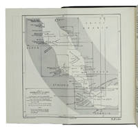
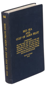
1955réf. ABC_47446London 1955. 8vo. Published for the Hydrographic Department Admiralty Original blue cloth with yellow lettering on the spine and the front board the supplement is loosely inserted at the end of the volume: original printed paper wrappers stapled. With a folding map printed on both sides 2 coloured plates with diagrams printed on both sides 28 plates showing coastlines and occasionally a map many printed on both sides and many some illustrations in text. 2 LI = LIII: II plus 1 1 blank 1 blank 518 1 1 blank pp; Supplement: 20 pp. The essential standard sailing directions for the Red Sea and Gulf of Aden corresponding with zone NP64 on the official Admiralty charts. These nautical works - pilot guides and charts - were published by the United Kingdom Hydrographic Office which provides the necessary hydrographic and marine geospatial data to all kinds of maritime organisations across the world. The publications are not only used by the British Royal Navy but can also be found on board the majority of international merchant ships. The data provided in the pilot guides and other publications are compliant with SOLAS the Safety of Life at Sea treaty guidelines and are updated constantly in weekly "Notices to mariners" and supplements to and new editions of the pilot guides whenever necessary.The present copy is the 10th edition 1955 of the pilot guide with sailing directions and other information on the weather currents radar ranges etc. relating to the Red Sea and Gulf of Aden including the supplement issued in 1957. It includes an erroneous "advertisement to the eight edition" by the Hydrographer of the Navy Rear-Admiral Kenneth St Barbe Collins 1904-1982. The advertisement states that with the publication of "the ninth edition" presumably this volume the previous edition and its supplements are cancelled since the most up-to-date information has been compiled in the new edition and the weekly "Notices to mariners" that appeared after the publication of the 11th edition. The 10th edition of 1955 and its 1957 supplement were made redundant with the publication of the 11th edition in 1967. Each subsequent edition of the pilot supersedes the last which have appeared infrequently depending on newly available information from the mid-19th century until the present day.The front paste-down and recto of the first free endpaper contain a "caution" notice and room for the notation of "supplements and annual summaries of notices to mariners relating to this book" the first two pages are printed on red-pink paper. The binding shows minor signs of wear around the spine and corners of the boards the gutter after page II is somewhat weakened the head edge of the wrappers of the supplement are very slightly browned. Otherwise in very good condition. AFRICA MARITIME HISTORY MIDDLE EAST & ISLAMIC WORLD Arabian Peninsula & Gulf States East Africa Navigation hardcover
1967réf. ABC_46470London: United Kingdom Hydrographic Office 1967. Grey-blue back wrapper; the two quires map and back wrapper held together by two metal staples. Blue cloth with title information in yellow on front cover and spine the supplement loosely inserted at the end of the volume. Large 8vo. The main work with 3 maps including 2 folding and 82 views of coastal profiles on 52 plates. The supplement with 2 folding maps on the two sides of a single folding leaf and 4 views of coastal profiles on 3 pages. With: NAVIGATION - RED SEA - PILOT GUIDE. Supplement No. 7 - 1977 to Red Sea and Gulf of Aden pilot eleventh edition 1967 corrected to 4th March 1977 Whenever reference is made to the pilot this supplement must be consulted.London United Kingdom Hydrographic Office 1977. The essential standard sailing directions for the Red Sea and Gulf of Aden corresponding with zone NP64 on the official Admiralty charts. These nautical works - pilot guides and charts - were published by the United Kingdom Hydrographic Office which provides the necessary hydrographic and marine geospatial data to all kinds of maritime organisations across the world. The publications are not only used by the British Royal Navy but can also be found on board the majority of international merchant ships. The data provided in the pilot guides and other publications are compliant with SOLAS the Safety of Life at Sea treaty guidelines and are updated constantly in weekly "Notices to mariners" and supplements to and new editions of the pilot guides whenever necessary.The present copy is the 11th edition 1967 of the pilot guide with sailing directions and other information on the weather currents radar ranges etc. relating to the Red Sea and Gulf of Aden including the supplement issued in 1977. The first two pages are printed on red-pink paper. Binding slightly rubbed and faded board edges very slightly soiled fore-edge of the supplement slightly frayed. Overall in good condition. United Kingdom Hydrographic Office, hardcover
1955réf. K3CC18ANEAK3London: published by the Hydrographic Department Admiralty 1955. Original blue cloth with title on spine and front board; supplement with original printed paper wrappers. 8vo. With a folding map printed on both sides 2 coloured plates with diagrams printed on both sides 28 plates showing coastlines and occasionally a map many printed on both sides and many some illustrations in text. Including: Supplement no. 1-1957 relating to the Red Sea and Gulf of Aden pilot tenth edition . Tenth edition of a work "comprising sailing directions for the Suez canal the Gulf of Suez and the central track for power vessels through the Red sea Straits of Bab-al-Mandab and Gulf of Aden ." p. III and more areas. Besides navigation it deals with the climate weather and ocean streams of the area. The first chapter also gives and "general description of countries bordering the Red sea and Gulf of Aden" p. V. Including two copies of the supplement. Spine slightly discoloured otherwise in very good condition. published by the Hydrographic Department, Admiralty, hardcover
1920réf. 59238Washington D.C.: Government Printing Office Hydrographic Office U.S. Navy 1920; 1930. Two vols. 8vo. viii 4 577 1 pp.; 1 38 1 leaves. With 1 large folding colour map. 1st vol. in green publisher’s buckram gilt lettering stamped on front cover & spine darkening to spine shelfwear deep embossed circular indentation at gutter margin where brass weight held book open; 2nd vol. Supplement in self-printed softcovers toning chipping & tears to spine still G set. Second edition stated of vol. I 1st edition of Supplement vol. of these surprisingly scarce coast pilot guides detailing the sailing directions for the treacherous coasts of Norway & Sweden notoriously treacherous for sailing and powered vessels. Prior to modern GPS systems and satellite navigation these regularly updated and revised navigation handbooks provided key sailing instructions drawing upon British Norwegian Swedish & Danish coast pilots. Worldcat locates only 1 copy of the Supplement U of W. Government Printing Office, Hydrographic Office, U.S. Navy, paperback
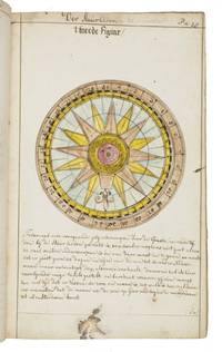
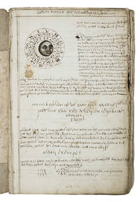
1735réf. LC4E9Q4RAGZBHolland 1735. Green paper wrappers made from a discarded prospectus or the wrapper of an instalment of a book ca. 1865 sewn at 6 stations some perhaps without supports later green cloth spine with the title in manuscript on the front wrapper. Folio 31.5 x 20.5 cm. A manuscript course in navigation written in brown ink on laid paper in a largely upright cursive hand with 6 colour figures including 2 volvelles about 100 black and white diagrams and numerous tables of data highlighted with a yellow wash. A detailed manuscript course in the art of navigation in folio format with figures in colour including two volvelles partly based on the very rare first edition in 8vo format of Klaas de Vries 1662-1730 Schat-kamer ofte konst der stier-lieden 1702; Crone 374 probably in the first issue not known to survive before the insertion of an additional quire between B and C. But the manuscript doesn't merely copy the printed book: at least much of the text differs and also at least some of the tabular data and some of the figures also have no direct equivalents in the printed book also not in later editions as far as we have seen. The colour illustrations include a compass rose 13.8 cm diameter with a ship in the centre directly copied from the folding engraved plate in De Vries and virtually the same size but the ship in the centre is copied in mirror image and De Vries's abstract floral decorations in the corners outside the circle are replaced by colour drawings of four different flowers one in each corner. The manuscript also directly copies De Vries's woodcut illustration of a human hand marked with the numbers "29" "9" and "19" on the thumb and the letters A B and C next to them presented as an aid to calculating the epact the number of days past the new moon on 1 January but the hand is rotated 180 degrees. Most of the examples of calculations use years in the period 1700-1711 though there are a few later ones one example uses the year 1809! which also largely agrees with the 1702 edition of De Vries though the examples are not identical. The clearest indication that the present manuscript follows the 1702 edition rather than a later one is that the tables giving differences between the positions of the sun and moon cover the years 1701-1704 as in the first edition before the insertion of an extra quire extending the tables to 1710 B8 was replaced at the same time not noted by Crone. All later editions we have seen give these tables and the examples of calculations for later years. Yet even in these tables the data in the present manuscript doesn't exactly agree with De Vries's. With a bookseller's ticket ca. 1901/1919. Very slightly browned with occasional minor spots or ink stains but still in good condition. The one leaf that appears to be lacking may have been deliberately cancelled by the compiler. The wrapper has a later cloth spine as noted and is somewhat worn. A fascinating manuscript course in navigation with volvelles and other figures in colour partly based on the very rare first 1702 edition of De Vries's handbook but not merely copying it.l For De Vries's 1702 handbook: Crone 374 collation not entirely correct. hardcover
1927réf. 59236Washington D.C.: Government Printing Office Hydrographic Office U.S. Navy 1927-1930. Three vols. 8vo. x 4 550; viii 4 560 pp.; 1 17 2 leaves. With 4 large folding colour maps 1 w/ toning at fore-edge from being improperly folded some edgewear numerous plates showing lighthouses. Two volumes uniformly bound in red publisher’s cloth gilt lettering front cover & spine darkening to spine fore-edges minor shelfwear dustsoiling minor paint drip at fore-edge 1 vol. Supplement in self-printed softcovers edgewear toning to fore-edges minor predation still VG- set. Third editions revised & updated of vols. I & II first edition of scarce Supplement of these coast pilot guides to South America and Antarctica in the 1920’s. Prior to modern GPS systems and satellite navigation these regularly updated and revised navigation handbooks provided key sailing instructions often drawing not only from Brazilian Argentine and British coast pilots as well as sailing reports from U.S. Navy vessels and those from merchant ships. The first large map delineates the requisite coast pilots for sailing in American waters and charts to be ordered from the Hydrographic Office while the second maps depict the sailing routes. The expanded 3rd edition is quite scarce with 1 copy located of both vols. in Worldcat NYPL. Government Printing Office, Hydrographic Office, U.S. Navy, paperback
réf. 321NAVIGATION BEZOUT Etienne Suite du cours de mathématiques à l'usage des gardes du pavillon et de la marine contenant le traité de navigation Paris P. H. Pierres 1793. 8° xii 296 pages 10 folding plates 44 leaves of tables ; contemporary green morocco flat spine gilt. Last part of Bezout's mathematical course dedicated to navigation. The plates were not bound in at the time but pasted to blank leaves so they could be fully unfolded while reading the text. The original edition was published between 1764 and 1769. Bezout was appointed examiner for the Marine Guard schools in 1764. His career was then mainly devoted to writing and teaching mathematics courses which were used for many years by candidates for military schools. This classic mathematics textbook was one of the main reference books for aspiring officers in the French royal armies in the second half of the 18th century. The last voume contains a treatise on navigation. A beautiful copy in contemporary green morocco.
1815réf. 55781New York: Printed for Edmund M. Blunt Oct. 1815. 8vo. xvi 297 86 pp. plus 2 pp. publisher’s ads. Woodcut-engraved front of the Blunt New York Shop 9 of 15 maps & charts 1 w/ partial loss several w/ additional sailing instructions and printed notices pasted-in manuscript sailing instructions and notes on versos of some. Original calf spine & calf on rear cover perished shaken dampstaining & toning still fair reference copy from the library of Captain Thomas Hall II 1804-1829 son of Captain Thomas Hall 1778-1816 who was lost at sea while sailing from Charleston to Boston in Feb. 1829 which his brother Charles Hall 1810-1829 ownership markings on endpapers of both w/ manuscript note on verso of ffep. that this is “good for a pint of ale” facing clippings about new lighthouses ca. 1821 listing the Ten Pound Island stone tower light house first built on the site in 1821. Preserved in brick-coloured linen cloth clamshell slipcase w/ printed label on spine. Eighth edition of this early vital tool for American sea captains and navigators first published in a much shorter version of only 122 pp. in 1796 and the first edition to bear only Edmund Blunt’s name as author. The original commissioned from Captain Lawrence Furlong proved so crude and unusable that Blunt arranged for it to be edited and rewritten. Blunt’s Coast Pilots were the earliest works of their type published in North America to cover the Atlantic Coast of the U.S. with sailing directions tide tables tables of latitudes and longitudes and as this copy shows were often working evolving documents with additional manuscript annotations and printed additions including in this case the Charleston Harbour map which is not included in the binding instructions and supposedly left out of the 8th edition. Printed for Edmund M. Blunt, hardcover
1807réf. 55849Philadelphia: Published by B.B. Hopkins and Co. and sold by W.P. Farrand No. 170 Printed by T. & G. Palmer 1807. 8vo. xxiii 1 270; 271-275 1 40 16 15-16 17-220 4 pp. including binders instructions and publisher’s advertisement. With 7 copper-engraved plates & maps 6 engraved by Benjamin Tanner. Contemporary polished brown calf red & gilt morocco spine label chipping to head of spine minor edgewear occasional interior foxing & toning still a VG- copy from the library of John L. Gow 1797-1866 noted Pennsylvania attorney w/ ownership label and markings on front pastedown. First American edition of this classic navigation handbook which was first published in 1804 and here contained substantial corrections to the tables of the latitudes and longitudes of places on the American coast and in the West Indies as well as an improved system of finding the longitude by P. Delamar of Philadelphia. Mackay 1760-1809 was noted Scottish mathematician and astronomer taught navigation and instructed in methods of how to find longitude. Shoemaker 12965. Published by B.B. Hopkins and Co., and sold by W.P. Farrand, No. 170, Printed by T. & G. Palmer, unknown
1920réf. 59229Washington D.C.: Government Printing Office Hydrographic Office U.S. Navy 1920;1929. Two vols. 8vo. vii 1 4 500 pp.; 2 32 2 leaves. With 1 large folding colour map. First in dark blue publisher’s buckram lettering stamped on front cover & spine minor soiling edgewear slight uniform interior toning 2nd vol. in self-printed softcovers oxidized toning & predation to outer fore-edges front chipped corner still VG- set. First editions of these very scarce coast pilot guides to waters off the West coast of India just after World War I drawing upon British Royal Navy coast pilots and U.S. Navy reports. Prior to modern GPS systems and satellite navigation these regularly updated and revised navigation handbooks provided key sailing instructions often drawing not only from British & Indian sources but also sailing reports from U.S. Navy vessels and those from merchant ships. The map outlines the available charts for the coastline off of Bombay down to Cape Comorin the Maldives and Sri Lanka. Worldcat locates only 2 copies of the scarce supplement. Government Printing Office, Hydrographic Office, U.S. Navy, paperback
réf. 234164Paris, Imprimerie royale, 1783 in-4, 22 pp., dérelié.
réf. 240355Paris, 1821 - 1822 29 pièces en un vol. in-8, demi-basane blonde, dos lisse orné de guirlandes dorées, pièces de titre cerise et bouteille, coins en vélin, tranches citron mouchetées de rouge (reliure de l'époque). Accrocs aux coiffes, deux charnières entièrement fendues.
réf. 232239Paris, Aubert, Lavigne [imprimé par Béthune et Plon], s.d. (1841) in-16, [2] ff. n. ch., 347 pp., avec des vignettes dans le texte, et 15 planches hors texte, dont une grande carte dépliante, et 14 vues, demi-percaline Bradel verte, dos orné de filets et fleuron dorés, pièce de titre fauve, couverture illustrée conservée (reliure de la fin du XIXe siècle).
1972réf. 50749Grenoble Editions des Quatre 1972 Grand in-4, veau bleu nuit, encadrement de filets froid sur les plats, dos sans nerfs orn petits fers dors; doublures et gardes de tabis vert, tranches dores (reliure de l'diteur).Belle dition reproduisant en fac-simil (au format) l'dition originale de ce trait publie par Moutard en 1781 et illustre d'un grand en-tte et de 9 planches hors texte. Tirage limit 570 exemplaires numrots. Un des 50 premiers exemplaires, seuls tre prsents dans une reliure de l'diteur. Etat neuf.
réf. 201107875Paris, Editions maritimes et d outre mer, s.d. ; in-12, 96 pp., broché, couverture illustr.
réf. 9481P., Imprimerie Nationale, (1790 ou 1791). 16 pp. in 8.
1920Very Good Turkish, Ottoman (1500-1928) Original color map. Elephant folio. (59x75 cm). In Ottoman script. [OTTOMAN MILITARY MAP of PATAGONIA and FALKLAND ISLANDS: ROUTE of DRESDEN] Alman kruvazörü Dresden'in takîbi ve tahrîbi. SMS Dresden cruiser's routes between 1913-1915 (World War 1) on the Patagonian shelf; western shores of South America, Patagonia and Falkland Islands. Dresden spent much of her career overseas. After commissioning, she visited the United States in 1909 during the Hudson-Fulton Celebration, before returning to Germany to serve in the reconnaissance force of the High Seas Fleet for three years. In 1913, she was assigned to the Mediterranean Division. She was then sent to the Caribbean to protect German nationals during the Mexican Revolution. In mid-1914, she carried the former dictator Victoriano Huerta to Jamaica, where the British had granted him asylum. She was due to return to Germany in July 1914, but was prevented by the outbreak of World War I from doing so. At the onset of hostilities, Dresden operated as a commerce raider in South American waters in the Atlantic, then moved to the Pacific Ocean in September and joined Maximilian von Spee's East Asia Squadron. Dresden saw action in the Battle of Coronel in November, where she engaged the British cruiser HMS Glasgow, and at the Battle of the Falkland Islands in December, where she was the only German warship to escape destruction. She eluded her British pursuers for several more months, until she put into Robinson Crusoe Island in March 1915. Her engines were worn out and she had almost no coal left for her boilers, so the ship's captain contacted the local Chilean authorities to have Dresden interned. She was trapped by British cruisers, including her old opponent Glasgow. The British violated Chilean neutrality and opened fire on the ship in the Battle of Más a Tierra. The Germans scuttled Dresden and the majority of the crew escaped to be interned in Chile for the duration of the war. The wreck remains in the harbor; several artifacts, including her bell and compass, have been returned to Germany.
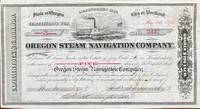
1518réf. 60240Seattle WA & Portland OR; San Francisco: Oregon Steam Navigation Company OSN Lithographers Britton Rey & Co. May 15 1874. Oblong 8vo. 9.5 x 5.25 in. 1 lithographed stock certificate printed in red & black image of OSN sidewheeler decorative borders signed by Wygant Ainsworth & Thompson at lower fore-edge transfer printed on verso signed by Edwin M. Lewis to Mrs. Kate J. Jones w/ stamps of paid dividends in 1878 and 1880. A nicely lithographed and rare original stock certificate issued in 1874 by Jay Cooke and the Northern Pacific Railroad to raise money for OSN after many of its original stockholders had sold out in 1867 as the Company continued to compete with Ben Holladay’s Pacific Mail Steamship Co. Unfortunately OSN became entangled with the declining financial woes of the Northern Pacific to the extent that by 1879 Henry Villard representing German Bondholders in 1879 purchased the OSN paid off the certificate holders by 1880 and the company disappeared into Villard’s transcontinental railroad. Edwin Lewis in Shasta OR transferred this certificate to Kate J. Jones May 1 1875 and shows the stamps of being paid off in dividends when the Northern Pacific absorbed OSN’s four railroads 26 steamboats and real estate in Portland Astoria The Dalles Umatilla OR and Vancouver WA. Oregon Steam Navigation Company (OSN), Lithographers, Britton, Rey & Co., unknown
Hardcover in 8, 291 pp., cartonnage sous jaquette illustree en couleurs. Très bel exemplaire. [CA31-5]
Hardcover, dark blue cloth on board, fold out maps and charts. loose inside is a supplement n°3-1961 relating to this edition book. This is a stapled booklet agin with fold outs and charts, staples are rusting. Book is a hefty volume of 525pp. Book has minimal wear to cover and binding. Good/No Jacket. [TX-8]
1710réf. ABC_46964The Netherlands 1710. Contemporary flexible paperboards. Folio 33.5 x 21.5 cm. With more than 300 mathematical figures and illustrations mainly full- half- and quarter-circle diagrams. The Dutch text is written in a clearly legible 18th-century cursive hand in brown ink. Early 18th-century Dutch manuscript on the art of navigation based on Klaas de Vries Schat-kamer ofte konst der stuurlieden . 1702. De Vries taught mathematics in Amsterdam his work proved very popular and appeared in numerous editions between 1702 and 1818. The author of the present manuscript unknown but was most likely a student of mathematics possibly even a student of De Vries himself at the beginning of the 18th century.The manuscript deals with several subjects regarding navigation including many different calculations for calendars for example the golden number the tides and determining the time at night. Furthermore theories and examples of correcting compass declination and determining the time of sunrise and sunset from the declination of the sun in combination with the pole star map reading and course calculation. It ends with approximately 50 sample problems in trigonometry and geometry showing the student author's mathematical work.Binding soiled edges frayed lacking the first 7 leaves quires 3 and 5 detached. With several ink stains the ink has bled through some leaves. Otherwise in good condition. An interesting manuscript on navigation probably from a Dutch student ca. 1702/13.l For De Vries's work: The Crone library 374 1st ed 1702. hardcover
réf. 558570Paris, Arthus Bertrand, s.d. [1869] In-4 broché, couverture muette postérieure, 12pp, 13 tableaux synoptiques des principales dimensions des navires de 75 à 1200 tonneaux de jauge.
1952réf. 95827Paris, Société d'éditions géographiques, maritimes et coloniales, impr. Keller, Maître-Imprimeur 1952 In-4 28,5 x 22,5 cm. Cartonnage éditeur remplié, dos muet, premier plat gaufré d’un blason polychrome, 170 pp., illustrations en noir & blanc dans le texte, 2 fac-similés hors texte, armoiries polychromes de la Ville de La Rochelle in fine. Bel exemplaire.
1757réf. 21280Paris H.-L. Guérin et L.-F. Delatour 1757 -in-4 plein-veau un volume, reliure de l'époque plein veau blond raciné in-quarto (binding full calfskin in-4), dos à nerfs (spine with raised bands), décoré "or" et à froid (gilt and blind stamping decoration), à filets "or" (gilt line) et filets à froid (blind-stamping line decoration), entre-nerfs à fleuron au fer plein "or" (floweret with full blocking stamp) dans un encadrement à double filets "or" avec fleurons fleurettes aux angles, titre frappé or (gilt title), pièce de titre sur fond bordeaux avec double filets "or" en encadrement, roulette "or" en pace des nerfs avec un filet à froid de part et d'autre des nerfs, coiffe de tête avec ancienne restauration (propre), mors avec restauration ancienne sur 4 cm en haut de la première de couverture mais reliure trés solide, dos trés légèrement frotté, plats décorés à froid d'un double filet à froid en encadrement, coins écornés, double filets "or" sur les coupes (fillets on the cuts) avec légers manques de dorure (blurred gilding), toutes tranches jaspées (all marbled edges) rouges (red edges), etiquette ex-libris gravée en noir aux "Armes" d'un Marquis "au lion naissant d'une forest de sinople" + tampon ex-libris encre noire de franc-maçon, titre imprimé en rouge et noir, orné de 15 planches dépliantes hors-texte gravées sur bois en noir et orné de bandeaux tête de chapitre historiés et de culs-de-lampe (illuminated of tailpieces) gravés sur Bois (engraving-wood) en noir, XXX + 520 pages, 1757 Paris : H.-L. Guérin et L.-F. Delatour Editeur,
réf. 201611058Paris, Seuil, 1990 ; petit in-4, 1135 pp., cartonnage de l'éditeur. En bon état avec sa jaquette et son rhodoide.