2 157 résultats
1944réf. LFA-126735016Une revue de 56 pages, format 165 x 245 mm, illustrée, brochée couverture couleurs, bon état
1943réf. LFA-126735004Une revue de 56 pages, format 165 x 245 mm, illustrée, brochée couverture couleurs, bon état
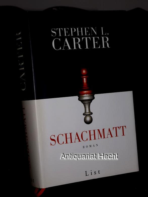
2002réf. 70534München : List, 2002. 858 S. ; 22 cm, gebunden, Orig.-Pappband mit Original-Schutzumschlag, Lesebändchen;
in-12, 319 pages, ill. hors texte N&B, broche, jaquette ill. Bel exemplaire. [HI-3]
900Santa Cruz I.s - Santa Cruz I. by Admiral Bruny D'Entrecasteaux 1793 Duff Group by Capt. J. Wilson of the Ship Duff 1797 Vanikoro I.s by Capt. Dumont D'Urville 1828 Swallow Group by Nav. Lieut. T.C. Tilly R.N. of the Mission Schooner Southern Cross. In the right side of the chart insert of Carlisle Bay Sketch by Lieut. H.R.M. Williams, H.M.S. Torch, 1897 and Graciosa Bay From a French Gov. Survey 1888. In the lower part of the chart insert of Mohawk Bay By Lieut. A.C. Scott, Assisted by Lieut. P. Robarts. H.M.S. Mohawk, 1898. London Published at the Admiralty 21st Febr. 1870, under the Superintendence of Capt. G.H. Richards, Hydrographer.Small corrections: 1929. Autore: Admiralty Charts. Luogo: Santa Cruz Island - South west Pacific Ocean. Anno: '900. Tecnica: incisione. Dimensioni: 634x474 mm
900Samoa Islands Island of Tutuila From United States Naval surveys between 1901 and 1922. In the upper left corner of the chart insert of Manua Islands - Tau, Ofu and Olosega Islands From a United States Naval survey in 1915 - and insert of Rose Island From latest information. Washington D.C., published June 1923, at the Hydrographic Office, under the authority of the Secretary of the Navy. Small corrections: Printed: April 1932. Folded editorially. Autore: Admiralty Charts. Luogo: Samoa Islands - Pacific Ocean. Anno: '900. Tecnica: incisione. Dimensioni: 789x1215 mm
1964262 p., illus. Hardcover Good condition; stain on front boards, fore edge soiled
1960Two books in a series of two fish guides. Color illustrations by Gordon Ertz. Oblong 24mo. Original glossy printed wraps. NH 1
2001238 pages. Index. "Relive these lost but not-so-distant days with stories and never-before-published photos of the sailors and their ships, the dory fisherman, and the raging sea that are as lively and invigorating as salt spray." - from dust jacket. Usual library markings. Somewhat above-average wear. Front hinge open. A worthy reference copy of this wonderfully illustrated reference. Book
1883In-8 gr. (mm. 245 x 145), tela editoriale (lievi aloni), pp. XII,865,(11), con figure nel testo e 15 tavole fuori testo, alcune più volte ripiegate. Nona edizione interamente rinnovata di questo "Nautical Directory for the South Atlantic Ocean". Solo qualche lieve fioritura altrimenti ben conservato.
réf. 1925952355.Gpaperback. Good. Access codes and supplements are not guaranteed with used items. May be an ex-library book. paperback
réf. 116048Plon Nourrit E. Plon, NOurrit et Cie Imprimeurs-Editeurs, Librairie Plon, sans date, 32 p., percaline éditeur, environ 32x26cm. Cartonnage un peu sali et dorures du titre passées, quelques frottements d'usage sur le cartonnage, page de titre légèrement salie, bon état pour le reste.
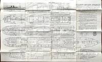
1928réf. 59682San Francisco Los Angeles CA: Los Angeles Steamship Co. Matson Navigation Co. ca. 1928. Oblong elephant folio. 37.25 x 23 in. deck plans printed on recto w/ illustration of SS City of Los Angeles in profile at upper left corner deck plans & descriptive text to right corner faint age toning minor wear a couple minor closed tears at fold creases still VG copy from the library of Archibald Angus MacDonald 1892-1977 stepson of famed southern California oil man William F. Byrne as well as oil company and drilling equipment owner and manager of MacDonald & Burns Oil Producers. First edition of this exceedingly scarce original deck plan for the S.S. City of Los Angeles which featured here a Boat Deck and A - D Decks with cabins staterooms and facilities all clearly demarcated. The S.S. City of Los Angeles was originally launched in 1899 as the SS Grosser Kurfurst for North German Lloyd and after being seized during World War I as a transport was renamed the USS Aeolus and then entirely refurbished for the Los Angeles Steamship Co. in 1922 as a very popular luxury liner until sold for scrap in 1937. No copies in Worldcat. Los Angeles Steamship Co., [Matson Navigation Co.], unknown
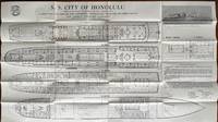
1928réf. 59683San Francisco Los Angeles CA: Los Angeles Steamship Co. 730 South Broadway Matson Navigation Co. ca. 1928. Oblong elephant folio. 37.25 x 23 in. deck plans printed on recto w/ illustration of SS City of Los Angeles in profile at upper right corner deck plans & descriptive text to right corner faint age toning minor wear a couple minor closed tears at fold creases still VG copy from the library of Archibald Angus MacDonald 1892-1977 stepson of famed southern California oil man William F. Byrne as well as oil company and drilling equipment owner and manager of MacDonald & Burns Oil Producers. First edition of this exceedingly scarce original deck plan for the S.S. City of Honolulu which featured here a Boat Deck and A - D Decks with cabins staterooms and facilities all clearly demarcated. The S.S. City of Honolulu originally launched in 1900 for the German Far East Mail Routes as the SS Kiautschou later as the S.S. Princess Alice for the North German Lloyd Line until seized by the U.S. in the Philippines in World War I. Renamed the USS Princess Matoika she carried over 50000 US Troops of the AEF to and from France and following the War carried much of the American US Olympic team to Antwerp in 1920. She resumed passenger service in 1922 as the SS President Arthur sailed for the American Palestine Line becoming the first ocean liner to fly the Zionist flag as she sailed to Palestine from New York and also featured the first women ship’s officers. She sailed for the Los Angeles Steamship Co. for about 3 years after refurbishment until a fire in Honolulu Harbor in 1930 and scrapping in Japan in 1933. No copies in Worldcat Huntington Library does have similar deck plan supposedly for the 1922 S.S. City of Honolulu but theirs is mostly likely a later deck plan as their displacement is listed at 20000 tons and the original City of Honolulu was launched as the 10500 ton SS Friedrich der Grosse North German Lloyd liner August 1896 scrapped after fire in her Oct. 12 1922 LASS Co. maiden voyage. Los Angeles Steamship Co., 730 South Broadway, [Matson Navigation Co.], unknown
Imprimerie de Monaco, 1895. In 4to grande, pp. 36 + 2 (Lègende de la Planche 1 e Lègende de la Planche 2 ) + le 2 tavole con veline sciolte, rispettivamente con 14 e 12 figure in litografia in colore, testo in francese, bross. edit. in carta muta protetta da velina recante i titoli e con alette di protezione. Importante raccolta di studi scientifici di biologia marina, realizzati sotto la direzione del Principe Alberto I di Monaco (Parigi, 1848 – Parigi, 1922). Alberto I, ancora molto giovane, ad appena ventidue anni, iniziò a coltivare la passione per le scienze naturali e in particolare per l'oceanografia. Si interessò ai nuovi strumenti che la tecnica metteva a disposizione per lo studio dei fondali marini, e con il sostegno di importanti scienziati compì studi oceanografici, realizzò mappe e carte nautiche. A lui si deve la fondazione di quello che sarebbe divenuto l'”Istituto Oceanografico” di Monaco, che include oggi un acquario, un museo e una biblioteca. Disponiamo di questo fascicolo VIII relativo a Epizoanthus, Caryophillia, Deltocyathus, Flabellum, Stephanotrochus, Balanophyllia. Piccole fioriture e alcune gualciture alla brossura, alcune fioriture marginali alla prima tavola, buono tutto l'interno, ancora intonso.
réf. 11034Le petit loup de mer- récits de chasse. In 4 cartonné, dos pincé vert, premier plat illustré en couleurs, de A. JOURCIN, titre illustré en couleurs, 64 pages, y compris le titre, 56 illustrations en noir dans le texte et en couleurs dans le texte, à pleine page et deux double page de Jean SAUNIER. Editions BIAS 1950 bon exemplaire
réf. QWA-15237Economica, 1992, in-8 br. (15,5 x 24), 338 p., Commission Française d'Histoire Maritime, coll. "Etudes d'histoire maritime", 32 cartes, bon état.
réf. QWA-15243Economica, 1992, in-8 br. (15,5 x 24), 338 p., Commission Française d'Histoire Maritime, coll. "Etudes d'histoire maritime", 32 cartes, bon état.
1930réf. 56514London UK & Hamilton Bermuda: The Royal Mail Steam Packet Company; The Herrington Co.; Trimingham Brothers 1930. Three pieces. 1st - 8vo. 16 4 pp. Colour-illustrated covers cover art of the RMSP Arcadian yapp edges NF; 2nd - 12mo. 2.75 x 3.5 in. 24 pp unpaginated. w/ photo illustrations double-page centerfold map colour-illustrated softcovers wraparound cover art of the Road around Harrington Sound; 3rd - 16mo. 3.75 x 5.25 in. which folds out to 21 x 7.5 in. pictorial map printed in black & light blue decorative borders lettering text on verso minor shelfwear still all VG from the library of noted opera singer Marion Talley 1906-1983 whose name along with her sister & mother appear in the list of passengers. First editions thus of these travel items to Bermuda in January of 1930 including the passenger list for the RMSP Arcadian which would be taken out of service later that year in October as well as two souvenir travel guides and maps. The RMSP Arcadian was originally built as the HMHS Asurias turned Hospital Ship and torpedoed during World War I and later as ammunition hulk before Royal Mail purchased her back and converted her into the Arcadian in 1923. Trimingham Brothers was a venerable Bermuda department store in Hamilton which sold everything from china to perfume golf shoes to rugs which sadly closed in 2005 due to severely falling sales. Herrington Co. was a very successful publisher of postcards travel guides maps and souvenirs in Bermuda. No copies in Worldcat. The Royal Mail Steam Packet Company; The Herrington Co.; Trimingham Brothers, paperback
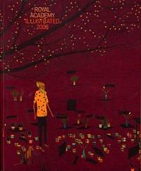
2008réf. 77505Harry N. Abrams Distribution . New. Paperback. FREE UPGRADE to Courier/Priority Shipping Upon Request - IN STOCK AND IMMEDIATELY AVAILABLE FOR SHIPMENT - Flawless copy brand new pristine never opened -- Text in English. 192 pp. With 218 ills. 211 col. . 24 x 20 cm. -- with a bonus offer--; The Royal Academy of Art’s Summer Exhibition in London has been an annual event since 1768. Today about a thousand works are selected to be shown each year from over 10000 entries. The exhibition which includes paintings drawings prints sculpture and architectural designs and models continues to be the largest open exhibition in the UK. First published in the 1870s Royal Academy Illustrated is an excellent way to stay current with trends in contemporary British art by surveying the highlights of each year’s show. This colorful collection features a cross-section of the works on display at the Summer Exhibition accompanied by installation shots of the galleries and an insightful introduction to the theme of the show. . 2008. 1905711123 . Harry N. Abrams (Distribution) paperback
1851réf. PACIFICO015869Longman Brown Green and Longmans London. 1851. First edition. Octavo. Two volumes in one: pp xii 352; xii 371. Four chromolithograph plates. Original blue cloth decorated in blind lettered in gilt.On the front free endpaper are two 19th century inscriptions one of which has been crossed through. Some foxing here and there. Head and tail of spine a bit scuffed. Some wear to edges. Very good. Very scarce in the intact publishers' binding. Longman, Brown, Green, and Longmans, London. hardcover
900Rough Sketches of Anchorages in the Solomon Islands. By M.r W.T. Wawn, Master, Brigantine "Ariel", 1888. In the left side of the chart insert of Tasman I.s or Niumanno Atoll, Atta Cove, Ariel Harbour From a Survey by Lieut. A.L. Jackson, under the direction of Lieut. Com. R.L. Hancock, H.M. Surveying Ship "Sealark", 1914, Manna Kwoi H.r. In the middle part of the chart insert of Deep Bay, Uras Cove, North Sister Anchorage, Double Bay. In the right side of the chart insert of Maramasike Passage. London Published at the Admiralty, 7th Oct. 1889, under the Superintendence of Captain W.J.L. Wharton, Hydrographer. Small corrections: 1930. Folded editorially. Autore: Admiralty Charts. Luogo: Salomon Islands - Pacific Ocean. Anno: '900. Tecnica: incisione. Dimensioni: 512x741 mm
1998réf. 1651931998 RODRIGUES - La troisième île des Mascarignes.L' Harmattan , 1998 , in8 broché,208pp . Cartes , tableaux.
réf. OCE145MAlbin Michel, 1930. In-8, relié, demi-cuir rouge, couverture non conservée, dos lisse orné, 318pp. Usure normale. Quelques frottements aux coins et tanches. Charmant exemplaire