Union Pacific Railroad CompanyBiblio.com

6 911 résultats
réf. 0265590922.Ghardcover. Good. Access codes and supplements are not guaranteed with used items. May be an ex-library book. hardcover
réf. 0265558166.Ghardcover. Good. Access codes and supplements are not guaranteed with used items. May be an ex-library book. hardcover
réf. 0282856293.Gpaperback. Good. Access codes and supplements are not guaranteed with used items. May be an ex-library book. paperback
1888réf. 52275Chicago: Rand McNally & Co. Printers 1888. 1888. UTAH RAILROAD. First Edition. 8vo. 21.5 x 10 cm. 8 1/2" x 4" color pictorial wrappers. 48 pp. illustrated from photographs fold-out map 'Tourist Map of Union Pacific and Connecting Lines' 20.5 x 59 cm. 8 1/4" x 23 1/2" present at the rear. The map is in nice condition and provides an excellent panorama of the Union Pacific Railway. Lines in red and run from Kansas City Atchison and Omaha to Denver and south to Gunnison or west through Cheyenne Granger and onto Portland with a spur up to Helena or west through Ogden and onto San Francisco with a spur down to Los Angeles. Blue shaded illustrations surround the lines which include a plowing scene Union Depot Salt Lake City Garfield Beach a mining scene Falls of the Yellowstone a ranching scene etc. Union Pacific produced guide for the would-be tourist of Salt Lake City including a description of the Mormons and their customs. Illustrated with nine full-page engravings from photographs by C.R. Savage. Also provided are List of Agents. Pullman Palace Car rates. Information on Salt Lake City tours Salt Lake City and the area surrounding "The Temple City" Beck's Hot Springs the Great Salt Lake Giant's Cave at Garfield Beach Echo Canon Weber Canon the Devil's Gate Ogden Ogden Canon etc. Detailed information on 9 different tours touting what the tourist might see and do. Covers lightly used light wear to fore-edges else a very good copy. Rand, McNally & Co., Printers, [1888]. unknown
réf. 0265572088.Ghardcover. Good. Access codes and supplements are not guaranteed with used items. May be an ex-library book. hardcover
1914réf. 15804San Francisco California: Janssen Press. Near Fine. 1914. First Edition. Soft Cover. Ca: 1914. 73/4" x 9" fully opened. Vertical center crease made by publisher. Seven pages including covers. Illustrated with B/W photographs and two maps. Transportation lines include: Steam Railroads; Electric Railroads; Automobile routes; Trolley and Excursion Boats. Also includes three sheets of unused stationary paper from the Fairmont Hotel Nob Hill San Francisco Ca. West California; 8vo 8" - 9" tall; 7 pages . Janssen Press paperback
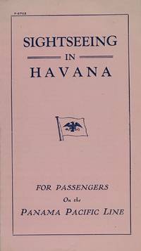
1920réf. 68517Printed in the U. S. A. 1920. Single pink sheet 16 x 18 cm. folded in half. Mention of the monument to sailors who died in the explosion of the Maine which wasn't built till 1925. Panama Pacific Line ended in 1938. unknown books
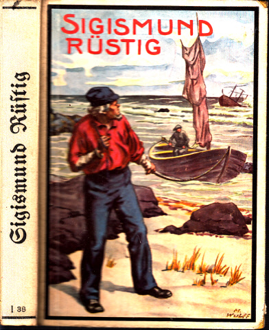
1922réf. 35277Berlin, Meidinger's Jugenschriften Verlag GmbH, 1922. 239 Seiten , 20 cm, Pappeinband
réf. 49706Berlin, Druck und Verlag von A. Weichert, ohne Angaben. 135 Seiten , 23 cm, Hardcover/Pappeinband
1906réf. 23056Pacific Press Publishing 1906. Pamphlet. Good - Used/None as Issued. Newspaper style 16 page piece of ephemera outside pages are chipped and torn. Light staining. Illustrated with black and white photos. Covers the San Francisco earthquake Please email for photos. Pacific Press Publishing unknown
1953réf. 28178Paris Plon 1953 Grand In-12 402 pp, une carte dépliante et 4 cartes dans le texte avec 14 illustrations
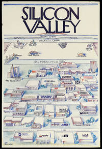
réf. 14949California: Pacific Ventures 1984. 912 by 610mm. 36 by 24 inches. Colour printed poster laid down on foamcore. A view of Silicon valley in its early days parodying Saul Steinberg's classic New Yorker cover "View of the World from 9th Avenue". This view shows Silicon Valley and the offices of its important technology companies looming large in the foreground. Among the companies named are Apple Hewlett Packard and Intel. As the view recedes across San Francisco bay there is a humorously foreshortened view of North America with much smaller views of Lake Tahoe Las Vegas New York and Boston with of course MIT. North Carolina and Texas' computer industry centres are competitively nodded at as well with Piedmont NC's Research Triangle and Austin's Silicon Gulch both shown. Further in the distance is the Atlantic Ocean with France and Germany shown as long islands followed by the Pacific Ocean culminating in Japan. "Silicon Valley" is written at the top of the image in the New Yorker's instantly recognisable font. By appropriating Steinberg's image a self-aware joke about New York City's self-centredness Silicon Valley lays claim to its own importance in the world. Funnily enough they weren't entirely wrong as the next few decades of innovation and economic success would prove. The company behind this image Pacific Ventures appears to have been a venture capital firm in the area that was involved in the technology sector. However we have been unable to find any mention of a Pacific Ventures operating at this time in Silicon Valley though there was a explosion of such companies in the area following Apple's 1980 IPO. Nonetheless the statement behind this image would have served a Silicon Valley based investment firm well. Saul Steinberg's "View of the World from 9th Avenue" appeared on the cover of the New Yorker in March 1976. It has since become one of the most popular and recognisable covers in the magazine's history and it spawned countless parodies as every city from Boston to Omaha clamoured to make a version of their own. Steinberg is quoted in a 2001 New York Times article as having said that if he had received the proper royalties " I could have retired on this painting." Pacific Ventures, unknown
1953con 4 carte n.t., una carta più volte ripiegata e 14 tavole f.t. Timbretto di estinta biblioteca.
1920162 pages. Index. Profusely illustrated with high quality detailed illustrations. Presents a vast range of Simonds products - far too many to list - with illustrations, specifications, pricing, and more. Undated but appears to be circa 1920. Unmarked. Average soiling and wear to red cloth exterior which which is brighly adorned with silver lettering. Some foxing to endpapers. Variable soiling to contents - nothing excessive. Narrow opening at page 133 otherwise binding sound. A rare vintage copy of this extremely informative and interesting catalog, prepared especially for the tall timber of the Pacific Coast. Book
réf. 88141Verviers (Belgique), Editions Gérard/Marabout, 1971. 11 x 18, 185 pp., nombreuses illustrations, broché, bon état.
1942Terza edizione del 1942 di questa interessante opera del giornalista e scrittore Paolo Zappa (1899-1950). Il volume è completamente dedicato a Singapore. Tra gli argomenti trattati: Il Mare britannicum, La citta del Leone, In giro peer Singapore, Il primo allarme, La spinta verso nord, continente vuoto, Isole della sonda, Vietnam, I cannoni sotto le palme, Il porto da guerra, La marcia, Il paese degli uomini liberiu, Gli Stati Uniti in Estremo Oriente, La flotta americana arrivera a Singapore, All'ora H di Singapore ecc... Alcune mappe all'interno: Istmo di Kra, Singapore, distanze fra il continente e le basi degli Stati Uniti nel Pacifico. In buone condizioni. Brossura editoriale originale in buone condizioni con lievi usure ai margini e dorso. Legatura in buone condizioni. All'interno le pagine si presentano in ottime condizioni con rare fioriture. In 8. Cm 19,5X14. Pp. 268+(4) Third edition of 1942 of this interesting work by the journalist and writer Paolo Zappa (1899-1950). The work is completely dedicated to Singapore. Between the issues treated: Sea britannicum, In tour for Singapore, The first alarm, Vietnam, Harbour war, March, United States in Far East, Amrican boat in Singapore, H hour in Singapore ecc... Alcune mappe all'interno: Istmo di Kra, Singapore, distnaces between continents and bases of United States in Pacific sea. In good conditions. Editorial cover in good general conditions slightly worn in the edges and spine. Binding in good conditions. Inside pages are in very good conditions with occasional foxings. In 8. Cm 19,5X14. Pp. 268+(4)
19798vo., First Edition, with 17 plates on 8, full-page map in the text and endpaper maps; grey cloth, gilt back, a near fine copy in unclipped dustwrapper. With striking wrap-around dustwrapper artwork by H. Knollys. Thorough account of the classic action in which RN destroyers sank a Japanese cruiser in the Malacca Straits. Enser, p.65; Law, 0614.
1897réf. ZB338801Washington: GPO 1897. Price HAS BEEN REDUCED by 10% until Monday Oct. 26 weekend SALE item 15 pp issued as 54th Congress 2d Session SD 52; light extraction roughness at spine now disbound in self wrappers; “relative to the amount due the sinking fund . on account of subsidies paid by the Pacific Mail Steamship Company”. - If you are reading this this item is actually physically in our stock and ready for shipment once ordered. We are not bookjackers. Buyer is responsible for any additional duties taxes or fees required by recipient's country. Photos available upon request. Washington: GPO, unknown
1965réf. 61662Washington DC: U. S. Government Printing Office 1965. Presumed first edition/first printing. Wraps. Good. No dust jacket as issued. Cover has some wear and soiling. Some page discoloration. 26r iv 412 p. Includes maps. Exhibits. 89th Congress 1st Session. House Document No. 237. This set of hearings heard from a broad spectrum of scholars and notables from the middle of the 20th century. U. S. Government Printing Office paperback
1971réf. IC268081971 [4], 432 p., 66 figs (= maps), paperbound. Very good copy.
201872 pages containing a 5 page article on Sir Francis Drake. Merchant, pirate and hero of the Armada, Sir Francis Drake was no mere man of his time. As Sam Willis argues, Drake defined the era It is one of the great storeys of British history and, sadly, one that sensible historians routinely disparage: that, as his nation faced existential peril at the hands of its mortal enemy, Sir Francis Drake (c.1540-1596) chose first to finish the game he was playing. The tale is well known, but bears retelling.
1949Boards with light rubbing to extremities. Bookplate. Former owner's stamp on first blank page and title page. Correction on copyright page ; With 31 plates in half-tone and 11 line illustrations in the text; 12mo; 281 pages
1907Sketches of Anchorages in the Tuamotu or Low Archipelago chiefly taken from the French Government charts to 1907. In the left side of the chart insert of Lagoon Entrance, Manihi Entrance, Avatoru Entrance, Tiputa Entrance, North passage to Rotoava , Passes into Amanu Atoll From the United States Goverment Chart, 1902, Pakaka Pass From the United States Government Chart, 1902. In the right side of the chart Lagoon Entrance, Amyot Bay, Mururoa Island, Fangahina I. From the United States Government Chart, 1902, Pakaka to Seignelay P.t.London Published at the Admiralty 9th July 1907, under the Superintendence of Rear Admiral A. Mostyn Field, Hydrographer. Small corrections: 1931. Autore: Admiralty Charts. Luogo: Tuamotu Islands - Polynesia - Pacific Ocean. Anno: 1907 [1931]. Tecnica: incisione. Dimensioni: 595x480 mm
1895108 p. + Frontis and Full page map. Illustrated with numerous photographs and drawings. 235 mm. Softcover. Original color pictorial wraps. Covers worn with loss. Title continues: "A Land of Rolling Plains, Boundless Grain Fields, Sculptured Lands, Alpine Lakes, Mining Camps, Indian Life, Dancing Rivers, Thriving Villages, Trackless Forests, Growing Cities, Lofty Mountains Penetrated by the Northern Pacific Railroad". Very good. **PRICE JUST REDUCED! W12 Bag1
1992270 pages. "Documents the men and the ships of a little-known period in west coast history. Pays funny and fascinating tribute to the unsung heroes of an inglorious history." - from dust jacket. Clean, bright and unmarked with lightest wear. Dust jacket in Archival-quality Brodart cover. Beautiful copy. Book