13.194 Ergebnisse
Best.-Nr. SONG1608701018Used: Good unknown
Best.-Nr. SONG0531115054Used: Good unknown
Best.-Nr. SONG0415476674Used: Good unknown
Best.-Nr. SONG0415951860Used: Good unknown
Best.-Nr. SONG159376149XUsed: Good unknown
Best.-Nr. SONG1740591445Used: Good unknown
Best.-Nr. SONG0304334510Used: Good unknown
Best.-Nr. SONG1558598480Used: Good unknown
1965Best.-Nr. ZB593981New Delhi: Committee on Natural Resources 1965. vi 92 pp. small folding map; library markings paper wrapers soiled with chipping at head and tail of spine. - If you are reading this this item is actually physically in our stock and ready for shipment once ordered. We are not bookjackers. Buyer is responsible for any additional duties taxes or fees required by recipient's country. Photos available upon request. New Delhi: Committee on Natural Resources, unknown
1935Best.-Nr. ZB599295Calcutta: Macmillan 1935. Volume 1 January-June 1935 viii 616 pp library book plate and markings but a sound copy in later cloth; a Catholic journal of general interest dealing with the various fields of human culture and higher concerns for the educated reader in India . - If you are reading this this item is actually physically in our stock and ready for shipment once ordered. We are not bookjackers. Buyer is responsible for any additional duties taxes or fees required by recipient's country. Photos available upon request. Calcutta: Macmillan hardcover
1951Best.-Nr. ZB359882Delhi: 1951. 12mo 35 pp library markings light extraction rioughness at spine later side stapling into original paper sides good; mostly on the Janaganamana and Vande Mataram. - If you are reading this this item is actually physically in our stock and ready for shipment once ordered. We are not bookjackers. Buyer is responsible for any additional duties taxes or fees required by recipient's country. Delhi: unknown
1940Best.-Nr. ZB394384Linguistic Society of India. 1940-1973. volumes 1-34; lacks volume 27. 1940-1973. partly bound library markings textually clean & tight PRICE IS FOR THE LOT. - If you are reading this this item is actually physically in our stock and ready for shipment once ordered. We are not bookjackers. Buyer is responsible for any additional duties taxes or fees required by recipient's country. Photos available upon request. Linguistic Society of India. unknown
1972Best.-Nr. ZB394333National Institute of Sciences of India 1972-1995. volumes 3-4; 11; 17-19; 24; 26. 1972-1995 complete volumes partly bound library markings textually clean & tight PRICE IS FOR THE LOT. - If you are reading this this item is actually physically in our stock and ready for shipment once ordered. We are not bookjackers. Buyer is responsible for any additional duties taxes or fees required by recipient's country. Photos available upon request. National Institute of Sciences of India unknown
Best.-Nr. 66101Printed at the Survey of India Offices H.L.O January 1945. Original colour-printed map of India folding between blue cloth covers lettered in gilt. Two inset maps. Old ownership inscription dated 9/5/45 to front pastedown. A very nice clean example. First published in 1926 this map was updated many times. The present example is the sixth edition. Printed at the Survey of India Offices (H.L.O), January 1945. hardcover
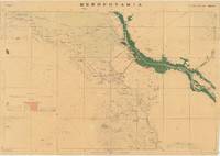
Best.-Nr. 66212Dehradun: Published under the direction of Colonel Sir S.G. Burrard K.C.S.I. R.E. F.R.S. Surveyor General of India 1917. Original heliozincographed map 73 x 105 cm printed at the Survey of India Offices in partial colour folding between publisher's original buff paper covers printed in black and with key map to back cover. The map compiled from ground and air reconnaissance is centred on Basrah and the Shatt al-Arab River with its date groves printed in green. The map shows roads suitable for wheeled traffic camel roads mule paths foot paths telegraph lines wells oil wells Mosques imamzadehs a shrine-tomb of a holy person in Shi'a Islam forts watch-towers deserted villages and springs pipelines graves trigonometrical stations post offices and telegraph offices and camping grounds. Map overprinted with numeric reference grid. Old ownership inscription to front cover. Some light toning some splits along folds some dampstaining and a few spots some light wear to covers scribbling to one panel of verso generally very good. A very scarce map with just one copy traced by OCLC at the Staatsbibliothek zu Berlin focusing on the key strategic regions of Basra-Zubair in south-eastern Iraq and the adjacent Khorramshahr area of Persia and it is one of the first maps to show Abadan the first oil boomtown of the Middle East. While there are oil wells marked throughout the map there is a particular accumulation of wells and refineries in and around Abadan on the far right which was the Middle East's first oil 'boomtown.' It appears here along with the Anglo-Persian Oil Company A.P.O.C. Refinery. Rich oil fields were discovered here in the early 20th century and in 1909 secret negotiations with the British led to the formation of the Anglo-Persian Oil Company which completed its refinery here in 1912. This company would play a central role in Iran's political and economic life throughout the 20th century. As military cartography it is marked 'For Official use only' in red to upper margin. Reg. No.888 D.D.D. 1917 2.D.O. S.I. 2000. Mesopotamia. Sheet No. 1. OCLC: 1235951984 Dehradun: Published under the direction of Colonel Sir S.G. Burrard, K.C.S.I., R.E., F.R.S., Surveyor General of India, 1917. unknown
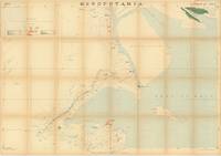
Best.-Nr. 66204Dehradun India: Published under the direction of Colonel Sir S.G. Burrard K.C.S.I. R.E. F.R.S. Surveyor General of India 1917. Original heliozincographed map 73 x 105 cm printed at the Survey of India Offices in partial colour folding between publisher's original buff paper covers printed in black and with key map to back cover. The map compiled from ground and air reconnaissance is centred on Kuwait Bay and extends to the northern portion of the Persian Gulf and the mouth of the Shatt al-Arab with its date groves printed in green in the north and Kuwait city in the south. The map shows roads suitable for automobiles camel roads mule paths foot paths unsurveyed or doubtful routes telegraph lines water wells and oils mosques imamzadehs a shrine-tomb of a holy person in Shi'a Islam forts watch-towers deserted villages springs pipelines graves trigonometrical stations post offices and telegraph offices and camping grounds. Map overprinted with numeric reference grid. Some light even toning slightly more so along folds a few trivial splits along folds generally in very good condition. Produced for official military use during the Mesopotamian Campaign of World War I this large-scale Survey of India sheet presents a detailed tactical map of Kuwait and the surrounding coast. Issued from Dehra Dun in 1917 under Surveyor General Sir Sidney Gerald Burrard the classified map was marked "For Official use only" to supply British and Indian Army staff officers with vital intelligence along the head of the Persian Gulf. The survey encompasses Kuwait Bay Failaka Island Bubiyan Island Khor Abdullah and the mouth of the Shatt-al-Arab near Fao. Topographic contours delineate the Jal-al-Zor ridge while cultural features record Kuwait town highlighting the British Political Agency and Shaikh's Palace alongside wells telegraph lines camel routes tracks and coastal anchorages. Hydrographic depth soundings and palm grove notations around the Shatt-al-Arab estuary provided crucial tactical information for naval supply lines supporting British operations in Iraq. Serving as Sheet No. 2 of the Survey of India's multi-sheet "Mesopotamia" mapping series this sheet exemplifies the rapid expansion of military cartography in the Middle East during World War I. Prepared using heliozincography a process favored for fast field reproduction of complex multi-color tactical plans copies were printed in limited numbers for official command personnel and are rare today. Historical maps focusing specifically on Kuwait especially those as early as this are extremely rare. OCLC traces just one copy at the Staatsbibliothek zu Berlin. OCLC: 1235957231 Dehradun, India: Published under the direction of Colonel Sir S.G. Burrard, K.C.S.I., R.E., F.R.S., Surveyor General of India, 1 unknown
Best.-Nr. ING9780847877157Rizzoli. New. Special order direct from the distributor Rizzoli unknown
2024Best.-Nr. SKU1740113Rizzoli 2024-09-03. hardcover. New. 9x1x11. New Book Ships with Tracking Rizzoli hardcover
1998Best.-Nr. NDICHU-0187-05-12-2026Praeger 1998-03-25. hardcover. New. 6x0x9. Praeger hardcover
1968Best.-Nr. 87661Greenwich CT: New York Graphic Society 1968. First American Edition. Folio. 33.5cm. Publisher's black cloth titled in gilt to spine and front board. Dustjacket and Slipcase. 295pp. Very light wear to extremities and spine ends tight and bright; internally clean and fresh lavishly illustrated throughout; in a clean sharp pictorial dustjacket with a little fraying to the head of the spine; and a grey card publisher's slipcase with a little wear and toning to the edges and corners. A very good copy. Partly sponsored by Unesco Heritage this is a large format showcase of examples of the arts and culture of the various peoples of the Himalayan region. Written and edited by Madanjeet Singh noted Indian diplomat writer and artist and a lifelong campaigner for world peace and harmony. New York Graphic Society unknown
Best.-Nr. 032502765X-11-31222306HEINEMANN. New. 0x0x0. HEINEMANN unknown
Best.-Nr. SONG8187111208Used: Good unknown
Best.-Nr. DADAX1120610400New unknown
Best.-Nr. SONG0674268032Used: Good unknown
Best.-Nr. ANAIS-174196721XMurdoch Books. hardcover. Good. 9.1x1.2x11. Buy with confidence. Excellent Customer Service & Return policy. Murdoch Books hardcover