13 375 résultats
2004réf. Q-0060527471Greenwillow Books 2004-03-02. Hardcover. New. New. In shrink wrap. Looks like an interesting title! Greenwillow Books hardcover
réf. DP5-03188-INAmistad. Library. Very Good. 9.25 5.38 0.54. Minimal wear to cover. Pages clean and binding tight. shelf wear. bumped edges. Hardcover. Library Amistad unknown
réf. 1016634773.Ghardcover. Good. Access codes and supplements are not guaranteed with used items. May be an ex-library book. hardcover
réf. B9781016634779Hardback. New. hardcover
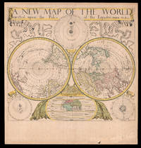
1680réf. 18434London: Sold by Will Berry at the Signe of the Globe between Chearing-Cross and White-Hall c1680. 425 by 480mm 16.75 by 19 inches. The first polar projection world map published by an Englishman Engraved map fine original hand-colour Ptolemaic Tychonic and Copernican diagrams of the solar system around map map of the ancient world below. The first world map on polar projection to be published by an Englishman. Polar Projection Polar projection is a type of azimuthal projection based on a plane perpendicular to the Earth's axis through the poles. On polar-centered azimuthal projections longitude is represented by radial straight lines and latitude by concentric circles or parallels. One of the earliest examples of a polar map of this kind is Mercator's 1569 world map on which the Arctic is shown in an inset map on a polar projection rather than included as part of the main image on the eponymous cartographer's projection. Other early double hemisphere world maps on north and south polar projections include Gerard De Jode's Hemispheriu ab Aequinoctiali Linea 1593; Isaac Habrecht's map of 1628; Janssonius' Typus Orbis Terrarum from the same year; Jean Boisseau's Nouvelle Description de toute la terre universelle of 1640; and Novus Planiglobe Terrestris Per Utrumque Polum Conspectus engraved by Joan Blaeu before 1672 the only extant example of which bears the later imprint of Gerard Valck published around 1695. The present map by Berry is an example of the first map on polar projection to be published by an Englishman. The Map Published around 1680 Berry's map shows both the north and south hemispheres on a polar projection at a scale of approximately 1:100000000 with both extending to the equator which is scaled. The coast of Australia is incomplete and California is shown as an island. Other cartographic myths include the massive single Great Lake and the Straits of Anian. The sizes of the Philippines and Japan are exaggerated and the southern tip of South America has been truncated due to the projection. At first glance the work would appear to be a copy of Blaeu/Valck Novus Planiglobe Terrestris Per Utrumque Polum Conspectus; and although Berry's English title is an almost direct translation of Blaeu's work it is no merely slavish copy. Berry has reversed the hemispheres and significant cartographic differences are evident especially in the depiction of South America. Surrounding the hemispheres are cosmological diagrams showing the Ptolemaic Copernican and Tychonic solar systems as well as a smaller map of the ancient world. This shows only Europe Asia and Africa and is divided into layers of "temperate zone" "frozen zone" "unhabitable" and "habitable by the Antients" regions. Ribbons ornament the upper left- and right-hand corners streaming from the ends of the simple title banner along the upper edge. The map was engraved by John Rich who also executed his road map of Great Britain the year before. William Berry 1639-1718 In his Printed Maps in the Atlases of Great Britain and Ireland 15791870 Thomas Chubb describes Berry as a bookseller geographer and engraver who was active between about 1670 and 1703. Berry was the son of a Warwickshire baker probably apprenticed alongside his future partner Robert Morden c1650-1703 to Joseph Moxon 16271691 an engraver mapmaker globe-maker and instrument-maker. His most enduring partnership was later with Morden and together they sold topographical works prints maps charts and globes. Among their shared works were A New Map of the English Plantations in America 1673 William Leybourn's An introduction to astronomy and geography: being a plain and easie treatise of the globes 1675 and Playing cards depicting the Counties 1676. In 1677 they petitioned the Attorney General for "a licence to do all general and particular maps of the several parts of the world according to an alphabetical manner and method first projected by them against any other undertakers". Although there are individual maps and globes prepared by the pair the larger project never came to fruition although Berry is best remembered as the "English Sanson" for the set of maps of the world that he corrected and amended after Nicolas Sanson which were issued separately between 1680 and 1689. Rare we are only able to trace one institutional example held at The Library of Congress and a smaller facsimile at the British Library. Not in Shirley; LC G3200 1675 .B4. Sold by Will Berry at the Signe of the Globe between Chearing-Cross and White-Hall,
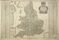
réf. 8243London: William Berry at the Sign of the Globe between Charing Cross and White Hall. 1680. No binding. Good. 590 x 880 mm. in two sheets joined early outline colour some professional repair to lower centrefold not affecting the image with one or two small surface marks none offensive trimmed just touching the upper left corner but generally with good margins all round otherwise in good condition. A fine rare English seventeenth century road map. In September 1678 Robert Morden fl. 1669 d. 1703 and William Berry 1639-1718 petitioned the crown for ""a licence to do all general and particular maps of the several parts of the world according to an alphabeticall manner"". Morden's connection with what appears to be the birth of the folio atlas is not heard of again. Berry began publishing a series of large two sheet maps with a group of the world and continents advertised in the 'London Gazette' from 1-5 July 1680. The world is also announced in the 'Term Catalogues' for the summer of that year. This only mentions the world map which would undoubtedly have been finished first and the continents would have followed. Berry did not advertise his next two sheet map that of England and Berry's first until February 1682. ""Through the 1680s Berry published nearly forty large maps of parts of the world sufficient to cover it all. From the late 1680s he clearly offered them bound together as a collection of maps as a handful of examples are known but this was clearly not the intention for the maps as none have borne any title page. Examples are known in the British Library the Library of Congress and the National Maritime Museum Greenwich all bearing either thirty-seven or thirty-eight maps. An example has been noted for sale by Maggs Brothers which bore sixty-nine maps the balance being made up of contemporary English maps by other cartographers dating the atlas to c.1704 and two further offered at Christies auctions in London in the 1980s"" Burden. This second map of England by Berry was announced in the 'Term Catalogues' for November 1685 and dedicated to James II who became King on 6 February 1685. He was deposed in the Glorious Revolution of 1688 by William III and for the second state offered here the dedication is altered to reflect the new King. The map is derived from the large wall map of the roads by John Adams published in 1677. It features the distances between towns within circles and by using straight lines. The inspiration for Adams' original work was undoubtedly the success of John Ogilby's book of roads entitled 'Britannia' published in 1675. Provenance: private English collection since the 1970s when it was acquired for £9! Burden 1996-2007 532; Phillips 1909- 3442; Shirley 1988 Berry 2.ii; Shirley 2004 T.Berr 1a no. 8; Tyacke 1973 p. 76; Tyacke 1978 no. 100 & pp. 109-10. William Berry at the Sign of the Globe between Charing Cross and White Hall. 1680 unknown
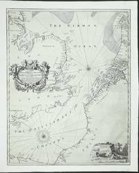
réf. 8773London: c.1672. No binding. Good. An UNRECORDED AND APPARENTLY UNIQUE EXAMPLE. 435 x 550 mm. a tear runs between Flanders and France there are two others above two more smaller tears are along the lower margin and one on the left side. Similarly a small thumbnail sized area has been filled in lower left of the title where there has been some loss at the fold. All tears have been professionally restored and the whole has been re-margined not backed and some of the engraved neatline is lacking on the right otherwise in good condition. An UNRECORDED AND APPARENTLY UNIQUE EXAMPLE of a sea chart of the English Channel and North Sea engraved by Francis Lamb. The address given in the imprint by William Berry was occupied by him in the period 1672-76. This chart was likely published at the time of the Third Anglo-Dutch War 1672-74. Morden and Berry had already published a map of the Seventeen Provinces of the Low Countries at the outbreak of hostilities. England declared war at the end of March 1672 and in the 'London Gazette' for 2-6 May were already advertising the map. It is highly likely that this chart was issued at a similar time. There is no mention retrospectively of any aspects of the war which might support an argument that says it was issued to illustrate the forthcoming conflict. ""Two of the most active publishers and mapsellers in London during the end of the seventeenth century were Robert Morden fl. 1669-d.1703 and William Berry 1639-1718. At the beginning of their careers it appears they worked in partnership. The 'Term Catalogues' detail publications together between 1673 and 1677. Most early records including those of the diarist Samuel Pepys refer to their activity in the production of globes. The last known evidence of a partnership was their petition to the crown in September 1678 for a licence to produce a folio atlas of the world in an 'alphabeticall manner'. This would become the sole production of Berry. Morden and Berry would both sell Richard Daniel's map of c.1679. Morden began with a shop shortly after the Great Fire of 1666. His reputation is underrated indeed Worms describes him as 'a prolific and inventive map maker whose critical reputation despite a string of innovations remains undeservedly low'."" Burden. The map is engraved by Francis Lamb fl.1667-1701. It extends from Normandy and Southampton to Texel and York and is centred on the Straits of Dover. An extensive search has revealed that this appears to be the only known example. Further research also identifies that the plate was purchased soon after by John Seller and is found included three known atlases. These are the 'Atlas Maritimus' owned by the Earl of Essex and those at Yale CBA Atlas Folio A; BL Maps 1066.6. When Seller entered financial difficulties and went into a partnership otherwise referred to as the Combine in 1677 a third state was issued. Examples of the map in this state have been located in three further atlases; Library of Congress 'Atlas Maritimus' Phillips 4150; BL untitled atlas Maps C.27.d.17 M.Sell 4a no. 53; NMM Thornton 'Atlas Maritimus' Sanderson 449 no. 10. A reduction of this map was also published by Morden and Berry at a similar date using the same addresses. Provenance: Clive A. Burden Ltd; private English collection. Burden 2007 431; Tyacke 1978 no. 11; Worms & Baynton-Williams 2011. c.1672 unknown
réf. 6134201388Saint Andrew Press Limited . Hardback. New. pp. 216 Saint Andrew Press, Limited hardcover
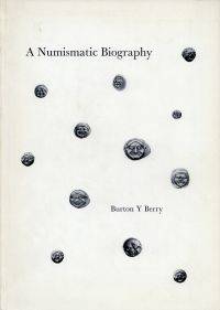
1971réf. 82391BB1971 . Beirut: Burton Y. Berry; Luzern: Bucher 1971. 4°. 89 1 S. 527 Abbildungen broschiert Einband leicht berieben; gut erhalten Vorliegend eins von 600 Exemplaren dieses Privatdruckes. unknown
réf. 1253831970. 90 pages over 500 illustrations. Hardback Text in English. 1970. hardcover
réf. 05240806.29C2Good. Signed "We Compliments" card tipped onto Dedication page. DJ worn with several tears along top and bottom edges of front panel. Boards show only minor shelf rubbing; binding intact. Text is otherwise clean and unmarked. hardcover
réf. 0849982251New. hardcover. New. Satisfaction Guaranteed or your money back. hardcover
réf. MAN02581W Pub Group 31291. Hardcover. Very Good. 8x5x0. 0849982251 Hardcover. Very Good in Very Good- dust jacket. Clean tight. Tear to dj. Bottom edge stamped. W Pub Group hardcover
1980réf. 58535San Francisco: North Point Press 1980. First Edition. 12mo pp. 89. Fine in a dj spine faded to yellow as usual. Freedman A38a. Signed and dated 1983 by Berry on the title page. poems. North Point Press unknown
1980réf. 58535San Francisco: North Point Press 1980. First Edition. 12mo pp. 89. Fine in a dj spine faded to yellow as usual. Freedman A38a. Signed and dated 1983 by Berry on the title page. poems. North Point Press unknown books
1980réf. 011495North Point Press 1980. First Edition. . Soft cover. As New/As New. Signed by author on the free front endpaper. Not inscribed. North Point Press paperback
1980réf. mon0000151587North Point Press 1980T. paperback. Very Good. 0.4000 in x 6.8000 in x 4.2000 in. Signed and dated 2/18/87 on ffep. First edition. Light rubbing on DJ now in mylar cover. Pages clean and binding sound. North Point Press paperback
réf. 0865470081.Gpaperback. Good. Access codes and supplements are not guaranteed with used items. May be an ex-library book. paperback
1980réf. 75543San Francisco: North Point 1980. First trade paperback printing. 89 pp. Near fine in wrappers and near fine price-clipped dust jacket with sunned spine. San Francisco: North Point, paperback books
1988réf. 052912Oxford University Press 1988. 1st Edition 1st Printing. Hardcover. Fine/Fine. Viii 206 Pp. Dark Blue Cloth. Gilt. First Printing 1988. Fine In Fine Dust Jacket Priced 15 Pounds Net Uk. Oxford University Press hardcover
réf. 21562873-nnew. unknown
réf. 21562873like new. unknown
réf. DADAX030020423XYale University Press 2015-01-13. Illustrated. hardcover. New. 9.50x6.50x1.00. Buy with confidence. Excellent Customer Service & Return policy. Yale University Press hardcover