FERRONNIERE, Erlé - MONGE, Jean-Baptiste (Texte et dessin)Livre Rare Book

9,984 results
2002ref. 1267772002 , MolaixAu Bord des Continents..., Morlais - 2002 - In-4, relié, cartonnage illustré en couleurs - 89 pages - Illustrations en couleurs in et hors texte - Contient une dédicace illustrée de Jean Baptiste Monge en page de titre et un ex-libris d' Erlé Ferronnière signé sur la deuxième de couverture + une autre dédicace non identifiée en page de garde
2004ref. 1267782004 , MolaixAu Bord des Continents..., Morlais - 2004 - In-4, relié, cartonnage illustré en couleurs - 96 pages - Illustrations en couleurs in et hors texte
1973ref. 101300München, Wilhelm Heyne Verlag 1973. 142 Seiten., 8°. ill. OBroschur.,
1994ref. 62002Frankfurt am Main : Suhrkamp 1994. 358 S. ; 18 cm kart., Taschenbuch, Exemplar in gutem Erhaltungszustand
1989Very Good English Paperback. Pbo. Cr. 8vo. (20 x 14 cm). In Turkish. 168 p. B/w ills. Rare first Turkish Edition of Dahl's 'Charlie and the chocolate factory'. Çarli'nin çikolata fabrikasi. [= Charlie and the chocolate factory]. Translated by Makber Biber.
1978trad. di Ugo Malaguti similpelle edit. con sovrac. ill., minimi difetti al bordo sup. della sovrac.
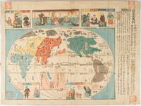
1850ref. 220779Japan. Circa1850. Colour woodblock map 37.1 x 50.5cm with inset colour woodblock illustrations a prior owner's chops at the corners light soiling and wear a little worming and a few small stains on the printed surface few small holes at folds map has been backed with washi painted with kakishibu persimmon on which Chinese characters are written and the title label of the map attached. Despite these signs of age and use this remains a charming map with considerable visual appeal and much intriguing detail. This intriguing map brings together factual and imagined information in its depiction of six continental areas: Asia Europe Libya Africa North America South America and Magellanica. Most likely published towards the end of the Edo period circa 1850 the central map distinguishes the six continents by colour and labels. Japan occupies the centre although Hokkaido is absent. Magellanica lies south of the equator with a note stating that red-haired people Europeans took the land and named it New Holland. Vertical lines mark longitude while horizontal lines resemble latitude and cold normal and warm zones are identified. Illustrations above the map and in insets depict people from places including Holland Ryukyu China and Korea. Imagined countries also appear among them the lands of Small and Big Peoples located in northern Europe and southern South America respectively. Text on the right describes the continents. . unknown
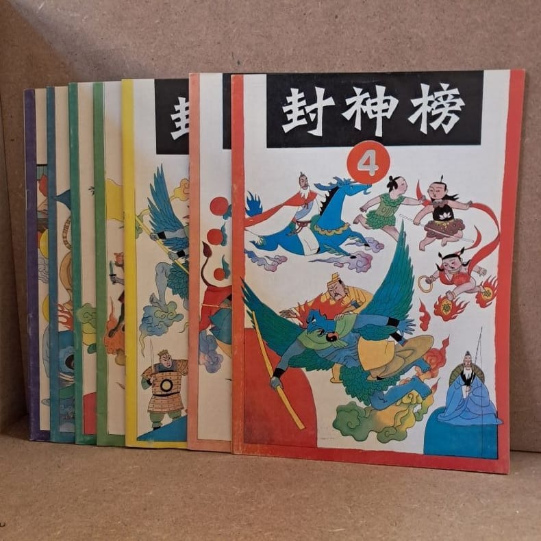
1990ref. 5981990 - agrafé - Shanghai People's Fine Arts Publishing House - Imprimé en Chine (Shanghai Printing Factory No. 10) - Premières éditions - 1990 - 7 volumes in-4 (26 x 18,5 cm) brochés par agrafage - 32 pages par numéro - Feng YINAN & Lu HUA (Illustration de couverture) - Wang MING, Lu CHENGHUA, Zeng MING, Gu BAOCHENG, Wang YUEQIANG & Chen AKANG (Illustrations) - Qian ZHIQING & Le MINGXIANG (Rédacteurs en chef) - Differents ISBNs : 7-5322-0783-8 / 7-5322-0784-6 / 7-5322-0785-4 / 7-5332-0786-2 / 7-5322-0787-0 / 7-5322-0788-9 / 7-5322-0789-7 - ENGLISH : Investiture of the Gods - Printed in China (Shanghai Printing Factory No. 10) - First editions - 1990 - 7 quarto volumes (26 × 18.5 cm), saddle-stitched - 32 pages per issue - Feng Yinan & Lu Hua (Cover illustrations) — Wang Ming, Lu Chenghua, Zeng Ming, Gu Baocheng, Wang Yueqiang & Chen Akang (Illustrations) — Qian Zhiqing & Le Mingxiang (Editors) - 中文:中国印刷(上海市印刷十厂)— 上海人民美术出版社出版 — 1990年7月第一版第一次印刷 — 7册四开本(26 × 18.5厘米),骑马钉装订 — 每册32页 — 封面绘画:冯忆南、陆华 — 插图:王明、鲁成华、曾明、谷宝成、汪跃强、陈阿康 — 责任编辑:钱志清、乐明祥。