FER, Nicolas deBiblio.com
2.182 Ergebnisse
Best.-Nr. 156417hardcover. Dediees a Monseigneur le Dauphin par Sontres Humble et tres Obeissant Serviteur et Geographe De Fer. Beautiful double-page engraved title page 4 38 2 60 28pp. This splendid atlas is illustrated with 32 engraved coastal charts including a folding wind chart and a general index chart of France. The double page maps have delicate outline hand coloring. An engraved divisional title page number 26 entitled "Les Costes de la Mer Mediterranee" is the 33rd plate. Short 4to 9.5 x 7.75 inches 17th Century calf well-worn; neatly rebacked; marbled endpapers red edges. Inscription in ink first fly leaf. Paris: Chez le Sr. de Fer dans l'Isle du Palais sur Quay de l'Orloge a la Sphere Royale. Avec Pri. du Roy 1690. Nicolas de Fer 1646-1720 was a prolific cartographer engraver and publisher who took over the family map business from his mother when she retired in 1687. The business flourished and he gained a great reputation in his lifetime and was appointed 'Geographer to the King' in 1690. This original edition the first atlas to bear his name was published in 1690 on the basis of an atlas published in 1634 by order of Cardinal Richelieu by the publisher Tassin who sold his plates in 1644 to Antoine de Fer Nicolas's father. Scarce. unknown
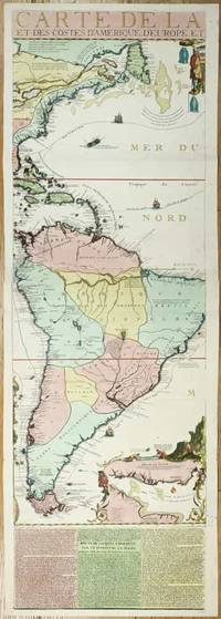
Best.-Nr. 11134Paris: 1713. No binding. Very Good. 1175 x 380 mm. full early wash colour with accompanying title page included a key map bookplate of the Duke of York on the verso in very good condition. Three sheets of an exceedingly rare fifteen-sheet wall map by Nicolas de Fer accompanied by the title with key map all in fabulous original colour. When published in 1713 it was the most extravagant map of America yet produced. It encompasses not just the American continent but the whole of the Pacific Ocean also. The map is made up of ten sheets in two rows of five and accompanied by 5 further smaller sheets of descriptive text which are not always present along the bottom. Here we offer the two sheets encompassing the east coast of North America and much of South America. The end of the War of Spanish Succession 1701-14 was near by 1711 and with a weakened Spain France began to eye North America. This renewed interest led to 'Louisiana' and the founding of New Orleans in 1718. Nicholas de Fer 1646-1720 was born the youngest of eight children to the map seller Antoine de Fer fl.1644-d.1673 and grew to be one of the most well-known mapmakers in France in the seventeenth century. He was apprenticed in 1659 to the engraver Louis Spirinx at the age of twelve. Following the death of his father in 1673 Nicholas worked with his mother to continue the family business. On her retirement in 1687 she passed the business to Nicolas in exchange for a crown a week unlimited bread and a pint of wine per day Pastoureau. His earliest known work is a map of the Canal of Languedoc in 1669. Arguably his most famous production is his wall map of America published in 1698. It is renowned for the beaver scene. In 1690 he became cartographer to the Dauphin of France and eventually to Louis XIV himself. From 1690 he began publishing his own books such as 'Les Forces de l'Europe' and the 'Petit et Nouveau Atlas' in 1697. His first wall map in 1694 was naturally of the world and this was followed by a set of four continents. The British possessions are hemmed into the coast of North America and include Acadia. In South America the mythical Lake Parime is excluded but the Orinoco and Amazon Rivers are still connected. Sea routes to and from the tip of South America are displayed and a fabulous inset of the Rio de la Plata is found lower right. The scene accompanying this is the mountain of Potosi the source of fabulous silver reserves with an image of panning for gold in the water nearby. The whole is wonderfully engraved by P. Starckman and dedicated to Monseigneur le Comte de Toulouse. The text beneath describes the voyage of Jacques le Hermite 1582-1624 in 1623-5 to present day Argentina and Tierra del Fuego. Le Hermite himself died on the voyage in Callao on the Peruvian coast. The map was a model for the later reduction by Henri Abraham Chatelain published in 1719 and Hermann Moll. An extremely rare map no examples are traced in the Library of Congress or the British Library. This example is from the magnificent collection of the Duke of York 1763-1827 unfortunately distributed at Sotheby's in May 1827. The second son of King George III he early on entered the military. His unfortune experiences can often be laid at the poor state of the military forces. It however led to the mocking rhyme 'The Grand Old Duke of York'. He is now credited with reshaping the armed forces to be more professional and merit based. He became Commander-in-Chief during the Napoleonic Wars. His collection when auctioned was described as being '88 folio double book cases' which contained 5500 maps each of which bore his distinctive bookplate with manuscript volume and map number below. Provenance: With bookplate of Frederick Augustus Duke of York 1763-1827; Sotheby's May 1827; collection of Hein Wenzel Berlin with stamp; Richard B. Arkway Inc. 2000; Juan and Peggy Rada Collection. Harley & Walters 1978; Howgego 2003 1713 unknown
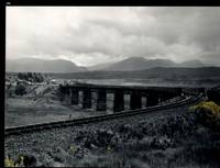
Best.-Nr. 32483AB1974. Scotland 1974-2002. Oblong-Folio 44 cm wide x 36 cm high. Hardcover / Original Full-Leather Folders with stong black cardboards and original tissue-guards. Excellent condition with only minor signs of wear. With hundreds of manuscript annotations on the photography the photography-technique film used and with extensive elaborations on each photograph in these albums. More images on request ! Album 1: Covers the years 1974 1977 and 1978. The West Highland Line is walked from Arrochar a 1977 driving and camping holiday and a 1978 seventeen day touring holiday with many nights sleeping in a car fill the leaves with c. 200 b/w original photographs. Album 2: Covers the years 1991 and 1992. It is noted that 1990 is the fourth year that returning locomotives from the Mallaig line will work south over the West Highland main line. Images of Corrour Summit Glasgow to Fort William trains and many many more bridges viaducts tunnels stations and signalling equipment fill the leaves. c.182 b/w original photographs. Album 3: Covers 1993. More colour photographs now fill the leaves and annotations cease to second half of album. c 270 b/w colour and tinted original photographs. Album 4: Covers 1999 and 2002. Many images from The Highlands Rail Festival in Sept 1999. c.250 b/w and colour original photographs. An extraordinary photographic record and passion project presented in 4 huge well-bound albums containing over 900 fine photographs taken curated and annotated by an unidentified railway enthusiast and talented photographer. The albums span 4 decades recording trips to some of the most scenic and famous rail locations in the UK. The West Highland Line is returned to again and again over the decades and our photographer captures Scotlands most dramatic landscapes and railways as the route passes on its way from Glasgow to Mallaig through sections including Corrour and Rannoch Moor. Albums and contents in fine condition. A tissue guard between every leaf protects the photographs within. A single photograph of a middle aged man among every other photograph which records a detail of the railway is the only clue to the albums previous ownership and perhaps authorship. Partial description by our colleague Dr.Christian White from Christian White Rare Books in Ilkley UK. __________________________________________________________________________________________________________ The West Highland Line Scottish Gaelic: Rathad Iarainn nan Eilean "Iron Road to the Isles" is a railway line linking the ports of Mallaig and Oban in the Scottish Highlands to Glasgow in Central Scotland. The line was voted the top rail journey in the world by readers of independent travel magazine Wanderlust in 2009 ahead of the notable Trans-Siberian line in Russia and the Cuzco to Machu Picchu line in Peru. The ScotRail website has since reported that the line has been voted the most scenic railway line in the world for the second year running. The West Highland Line is one of two railway lines that access the remote and mountainous west coast of Scotland the other being the Kyle of Lochalsh Line which connects Inverness with Kyle of Lochalsh. The line is the westernmost railway line in Great Britain. At least in part the West Highland Line is the same railway line as that referred to as the West Highland Railway. History: The route was built in several sections: Glasgow Queen Street to Cowlairs Junction - Edinburgh and Glasgow Railway Cowlairs Junction to Bowling - Glasgow Dumbarton and Helensburgh Railway later absorbed into the Edinburgh and Glasgow Railway Bowling to Dumbarton Central - Lanarkshire and Dumbartonshire Railway operated by the Caledonian Railway Dumbarton Central to Dalreoch - Caledonian and Dumbartonshire Junction Railway Dalreoch to Craigendoran - Glasgow Dumbarton and Helensburgh Railway Craigendoran to Fort William opened 11 August 1894 - West Highland Railway sponsored by the North British Railway Crianlarich to Oban - Callander and Oban Railway operated by the Caledonian Railway. There is an additional section from Fort William or a junction near Fort William to Mallaig built as the Mallaig Extension Railway. The West Highland Railway approved the construction of the line at their annual meeting in January 1895. The line faced potential closure as part of the Beeching cuts in 1963 and again in 1995 due to reduced revenues. Route description: Shortly after leaving Glasgow Queen Street station and beyond Queen Street Tunnel the line diverges from the main trunk route to Edinburgh Waverley and Perth at Cowlairs and follows a northwesterly course through the suburbs of Maryhill and Kelvindale. Between Westerton and Dumbarton the route is shared with the North Clyde Line to Helensburgh Central before branching northward at Craigendoran Junction towards Garelochhead the section where the West Highland Line itself is generally accepted to begin. It gives high-level views of the Gare Loch and Loch Long before emerging alongside the northwesterly shores of Loch Lomond then climbs Glen Falloch to Crianlarich. The branch to Oban diverges at Crianlarich an important Highland junction of both road and rail and runs through Glen Lochy to Dalmally and through the Pass of Brander to reach salt water at Taynuilt and Connel Ferry before a final climb over a hill to Oban. About three miles five kilometres from Crianlarich the Mallaig and Oban routes both pass through the village of Tyndrum but they are served by separate stations making it an unusually small settlement to be served by more than one railway station. After Bridge of Orchy the line to Mallaig climbs onto Rannoch Moor past the former crossing point at Gorton Crossing to Rannoch station. In winter the moor is often covered with snow and deer may be seen running from the approaching train. The station at Corrour on the moor is one of the most remote stations in Britain and is not accessible by any public road. This is the summit of the line at 1347 ft 410 m above sea level. Carrying on northwards the line descends above the shores of Loch Treig and through the narrow Monessie Gorge. The final stop before Fort William is Spean Bridge. The section between Fort William and Mallaig passes over the Glenfinnan Viaduct through Arisaig with its views of the Small Isles of Rùm Eigg Muck and Canna and the white sands of Morar before coming to Mallaig itself. With the exception of the route between Glasgow Queen Street and Helensburgh Upper and the short section between Fort William Junction and Fort William station the railway is signalled using the Radio Electronic Token Block controlled from the signal box at Banavie station. Notable railway-related features Glenfinnan Viaduct The Horse Shoe Curve between Upper Tyndrum and Bridge of Orchy The Cruach Rock snowshed between Rannoch and Corrour Glenfinnan Viaduct between Locheilside and Glenfinnan The Pass of Brander stone signals between Dalmally and Taynuilt Arisaig is the most westerly railway station in Great Britain West Highland Line in film: Train crossing bridge at Banavie The summit of the line just north of Corrour Glenfinnan Viaduct on the line between Fort William and Mallaig is a filming location for the Hogwarts Express in the Harry Potter series of films. Eddie McConnell's poetic documentary A Line for All Seasons 1970 showcases the line and its history set against the scenery of the western highlands as it changes through the seasons. Corrour features in Trainspotting 1996 directed by Danny Boyle. Source: Wikipedia hardcover
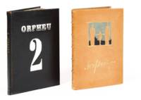
1915Best.-Nr. 2787Lisbon 1915. First editon. In bit later decorated bindings. In very good condition. First editon. In bit later decorated bindings. Complete collection of the famous Portuguese avant-garde magazine directed by Fernando Pessoa and Mario de Sá-Carneiro. The first Portuguese review entirely dedicated to Futurism. Financial difficulties prevented the publication of the third volume ready for printing. Despite its short-lived existence the magazine had a decisive influence on Portuguese literature. On the occasion of its centenary Gallimard Editions published a facsimile edition in French. The second issue reproduces four "resolutely futuristic" drawings by the painter Santa Rita as well as the famous phonetic poem Poemas sem suporte by Mario de Sá-Carneiro and Chuva obliqua poemes interseccionistas by Fernando Pessoa. Illustrations and texts by Pessoa Santa Rita Mario de Sa Carneiro Raul Leal Viloente de Cysneiros Armando Cortes Rodrigues and others Very rare. Collection of Jean-Paul Kahn. unknown
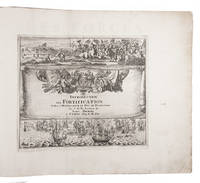
1702Best.-Nr. 23526Paris 1702. Oblong 1mo 30 x 37 cm. chez l'auteur" = Nicolas de Fer a false imprint Contemporary tanned sheepskin sewn on 5 cords gold-tooled spine with the title in the 2nd of 6 compartments. Ad 1 with 10 letterpress title pages in red and black for the 10 parts; 5 engraved titles for parts 1-5 that for part 5 repeating that for part 2; plus 234 beautifully engraved plates a few folding with 366 maps and views of fortified cities. Ad 2 with an engraved title page 2 letterpress title pages in red and black and 40 engraved plates including 2 folding labelled A-S in part 1 and T-Oo in part 2. 2 works in 12 parts or volumes bound as 1. Splendid atlas of fortifications of the cities of Europe plus Malta and some other Mediterranean sites combined with a maritime atlas of the French coasts published by Pieter Mortier 1661-1711. Both are based on the similar publications of Nicolas de Fer 1646-1720 and falsely indicate that they were published by him.Ad 1: The atlas of fortified cities of Europe. Many of the plans show the work of the greatest 17th-century masters of the art and science of fortification including Samuel Marolois Simon Stevin and Sébastien Le Prestre de Vauban. The last two parts contain primarily smaller maps printed 4 to the page. Ad 2: The maritime atlas of the coasts of France. It also shows the fortifications along the coasts so it complements the fortifications atlas and was clearly designed to match it in format and style. With the caption of one plate cut off and 2 plates and 1 letterpress title-page somewhat browned. Further in good condition. A couple plates are bound in the wrong volume. A splendid fortifications atlas.l Ad 1: Muller Historieplaten 3034a; cf. Pastoureau Atlas français IX A & H pp. 203-209 213: Paris Fer ed. 1690-1695 & Amsterdam Mortier ed. 1702 with different title; Phillips pp. 256-7 other ed.; Ad 2: Muller Historieplaten 3034a; Pastoureau Les atlas français XVIe-XVIIe siècles Fer VIII B p. 203 cf. pp. 201-203; for Mortier see: Koeman III pp. 4-10 and IV p. 423. CARTOGRAPHY GEOGRAPHY & TOPOGRAPHY EUROPE MARITIME HISTORY MILITARY HISTORY Atlases & Globes Charts & Maps City Plans Topography & Views Eastern Mediterranean & Cyprus Fortification & Military Architecture France Malta Military History 18th Century Navigation unknown
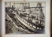
Best.-Nr. 8031London: 1863-69. No binding. Very Good. PHOTOGRAPHIC RECORD OF SHIPBUILDING IN THE 1860s. Oblong quarto 235 x 310 mm. full contemporary calf gilt and blind panelled boards with ornate gilt corner feature rebacked preserving original spine gilt ruled raised bands with ornate gilt pattern gilt edged. With 89 albumen photographic prints. A fascinating PHOTOGRAPHIC RECORD OF SHIPBUILDING IN THE 1860s at the Thames Ironworks and Shipbuilding Company. They cover the period 1863-69 and likely record all of the significant work undertaken in this period. The Thames Iron Works were the largest shipbuilder on the river Thames. Its shipyard was located at the mouth of Bow Creek in the east end of London. Although principally a shipbuilder it expanded into civil engineering supplying materials for Isambard Kingdom Brunel marine engines cranes electrical engineering and even later into motor cars. Founded in 1837 the company was struggling until in 1857 Peter Rolt MP for Greenwich merchant and descendant of the Pett shipbuilding family took control. At the time of the earliest photographs in this album the huge site had the capacity to build 25000 tons of warships and 10000 tons of mail steamers. It is most famous for constructing HMS 'Warrior' the world's first iron hulled armour-plated warship. Launched on 29 December 1860 it overnight rendered obsolete all existing warships worldwide. It was at the time the world's largest. Following the success of HMS 'Warrior' and HMS 'Minotaur' photographed orders arrived from navies all over the world. The Company also built the Prussian Navy's first iron-hulled warship the SMS 'König Wilhelm I' photographed in 1868. It is interesting to note also that the 1860s was the decade of considerable loss of shipping which opened a huge debate led by Samuel Plimsoll MP on load lines on vessels. Many of the vessels photographed already show load lines following the recommendations of Lloyd register known as 'Lloyd's Rule'. The majority of the photographs feature the construction of vessels but towards the end particularly there are images of the various buildings Yards and Docks. There are also four of ship models a cross section a lighthouse destined for the West Indies a model steam engine six of plant works and three of paintings. Below is a list of the vessels illustrated which can be readily identified: RUS 'Pervenetz' Imperial Russian Navy 1863 'Alexandra' HMS 'Minotaur' Royal Navy 1863. This was the longest single-screw warship ever built HMS 'Valiant' Royal Navy 1863 'Napoleon III' 1863 'Izzeddin' paddle steamer 1864 'Nyanza' Peninsular and Oriental Company's Paddle Wheel Steamer 1864 'Sultan Mahmoud' Turkish Frigate 1865 'Charkieh' 1865 'Tanjore' Peninsular and Oriental Company's 1865 SNS 'Vitoria' Spanish Navy 1865 'Earl de Grey and Ripon' 1866 HMS 'Waterwitch' 1866. She was one of only three armoured gunboats built for the Royal Navy. Uniquely she was powered by Ruthven's 'hydraulic propeller' making her the first ship to employ waterjets 'Henry Morton' 1866 'Ottawa' 1866 'Adia' 1866 'Vanguard' 1866 'Anglia' 1866. An iron paddle tug 'Wilhelm I' 1868. For a time the largest and most powerful warship in the German navy 'Golden City' 1866 'Haswell' 1866 HMS 'Serapis' 1866 Royal Navy troopship 'Mauritius' 1867 'Kronprinz' 1867 'John Penn' 1867 HMS 'Royal Sovereign' 'Champion of the Seas'. Held the record for the fastest day's run in 24 hours: 465 nautical miles. It was not broken until 1984! HMS 'Volage' 1869 1863-69 unknown
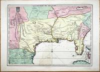
Best.-Nr. 9768Paris: A Paris dans l'!sle sur Ie Quay de l'Orloge a la Sphere Royale avec Prive. Du Roy 1715. 1715. No binding. Good. EXTREMELY RARE FIRST STATE OF NICOLAS DE FER'S LANDMARK MAP IN FULL CONTEMPORARY WASH COLOUR. 465 x 640 mm. in full early wash colour faint water stain lower centrefold otherwise in excellent condition. EXTREMELY RARE FIRST STATE OF NICOLAS DE FER'S LANDMARK MAP IN FULL CONTEMPORARY WASH COLOUR. This printed map is derived from the manuscript of Guillaume de L'Isle in 1701 a significant map in the history of the depiction of the Mississippi Valley. Considerable advances were made in the understanding of this region particularly along the Gulf of Mexico in the first two decades of the 1700s. Much of this new information came at the hands of French explorers. In Paris the key mapmakers processing this information were Claude de L'Isle 1644-1720 his son Guillaume de L'Isle 1675-1726 and Nicolas de Fer 1646-1720. The three significant printed maps of the time are De L'Isle's Carte du Mexique et de la Floride 1703 La Riviere de Missisipi et ses Environs 1718 and this de Fer 1715. The de Fer is an important link in the understanding of the region. The most prominent unknown at the beginning of this period was the location of the mouth of the Mississippi River. Whilst René-Robert Cavalier de La Salle 1643-87 had proved that the Mississippi River flowed into the Gulf of Mexico the position of its mouth was ill conceived and displayed too far west on contemporary maps. 'During the 1690s attempts had been made to encourage an expedition to follow on La Salle's claims to the Mississippi valley. All of them foundered until a government-sponsored one by Louis Phélypeux Comte de Pontchartrain Minister of the Navy. He ordered Pierre le Moyne d'Iberville to command the voyage. He was the third of fourteen children of Charles Le Moyne 1626-83 who had arrived in Canada in 1641. Pierre 1661-1706 was born at Ville-Marie Canada and by the age of fourteen had sailed to France returning in 1678. In 1686 he was present with some of his brothers fighting the English in Hudson Bay under Pierre de Troyes. On another voyage to the same region he was trapped in the ice along with the English and there spent the winter of 1689-90 until freed in the spring. Most of his experience was in Canada although he did take part in an attack on Schenectady in New York 1690. Pontchartrain's instructions to d'Iberville were to establish a colony at the mouth of the Mississippi River and therefore enable control of the huge waterway. He sailed from Brest on 24 October 1698 with three vessels and 200 colonists arriving at Ship Island off present day Biloxi Mississippi 25 January 1699. Having put ashore the colonists he embarked in four small boats up the Mississippi delta until he reached the Iberville River which he entered. Crossing Lakes Maurepas and Pontchartrain he returned to the coast. He then began construction of Fort Maurepas on Biloxi Bay before leaving for France on 4 May 1699' Burden. 'D'Iberville returned to Biloxi promptly arriving 7 December 1699. In the New Year he constructed Fort Iberville eighteen leagues upriver from the mouth of the Mississippi … The most detailed record cartographically of d'Iberville's voyages can be found in Nicolas de Fer's Les Costes aux Environs de la Riviere de Misisipi 1701' Burden. The results of these explorations were recorded on Guillaume De L'Isle's 1701 manuscript. It was one of the first to display the Mississippi delta and to illustrate the extent of the Missouri River. Cumming described it as 'notable for its early representation of the Carolina Trading Path' from Charleston Carolina to the Mississippi river. De L'Isle never published a printed version of the manuscript. The second state of Claude and Guillaume De L'Isle's L'Amerique Septentrionale in 1700 records a delta but is not directly derived from the manuscript. The only printed version was this map issued by De Fer in 1715 with additional information. Jackson notes 'the s A Paris dans l'!sle sur Ie Quay de l'Orloge a la Sphere Royale avec Prive. Du Roy 1715. 1715 unknown