de Fer, NicholasBiblio.com
2 176 résultats
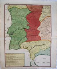
réf. 2539Europe: Paris de Fer. N 1705. Copper engraved map of Portugal and part of Spain by Nicholas de Fer from his "Atlas ou Recueil de Cartes Geographiques" Original old full wash colour; verso blank. The map shows the south western part of the Iberian peninsular: Portugal; the Algarve and parts of the kingdoms of Estramadura AndalusiaGrenada Leon and Castille extending down to the straits of Gibraltar. Good dark impression; colours bright; old ink number to upper blank margin; guard attached to upper margin; light diagonal creases towards centre fold other small printers creases/ wrinkles to centrefold; old ink title to verso. Nicholas de Fer 1646 - 1720 was the son of cartographer Antoine de Fer. Nicholas was established as an engraver cartographer and map publisher in Paris. De Fer was a prolific cartographer with over 600 maps and atlases to his credit. De Fer's work though replete with geographical errors earned a large following because of its considerable decorative appeal. In the late 17th century De Fer's fame culminated in his appointment as Geographe de le Dauphin a position that offered him unprecedented access to the most up to date new cartographic information. He would later be appointed Geographe de Roi to the kings of both France and Spain. Pastoureau FER II C 72. Europe Spain & Portugal Portugal Paris de Fer. N 1705 unknown