DE FER, NicolasABAA
121 résultats
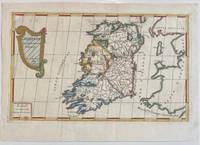
1689réf. 322292Paris: Nicolas De Fer 1689. unbound. Map. Engraving with original hand outline color. Sheet measures 13" x 9.5". Image measures 12.75" x 7.25". This is a lovely 1689 map of Ireland by Nicolas De Fer. Depicts the Emerald Isle in its entirety color coded and subdivided into its four provinces of Ulster Connacht Leinster and Munster. Parts of Scotland the Isle of Man and England and Wales are also visible. Major towns lakes rivers and islands are noted in Ireland and mountains beautifully rendered in profile. The title cartouche represents the Celtic Harp. The map is in good condition with minor toning along the original fold. Original platemark visible. Nicolas de Fer 1646-1720 was a prolific cartographer engraver and publisher who took over the family map business from his mother when she retired in 1687. The business flourished and he gained a great reputation in his lifetime and was appointed 'Geographer to the King' in 1690. This map demonstrates his skill and provides a curious yet alluring mixture of history and geography. Nicolas De Fer unknown books
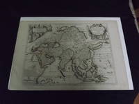
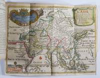
1722réf. biblio10Engraved double page map 28" x 20" wide margins hand colored in outline two uncolored pictorial cartouches. Expert and nearly invisible repairs along centerfold normal aging; about near fine. Impression is bright and clean. Nicholas De Fer 1646-1720 was a highly respected and prolific French cartographer whose maps were valued for their decorative appeal. Around 1690 he was made the geographer to the Dauphin and published his first atlas. He would become geographer to other high-ranking individuals in French and Spanish society. The present map is detailed and attractive map of Asia with a cartouche showing Chinese at the upper left and Indians in the upper right. The map covers a lot of territory showing Arabia and the Persian Empire in the West and Japan in the east but goes as far south as the Isle of Borneo and Java. Part of Eastern Europe is also visible. Library missouri website. books
1995réf. 143670Chicago IL: Museum of Contemporary Art 1995. First edition. Softcover. 96 pages. Exhibition catalog for a show that ran June 24 through August 20 1995 in Chicago and then traveled to Paris Helsinki and London for additional dates. Text in English and French by Jean-Francois Chevrier and Briony Fer. Includes numerous color images by Wall a list of previous exhibitions and selected bibliography. A tight near fine copy in French style wrappers with a small sticker abrasion to the bottom corner of the rear cover. Museum of Contemporary Art unknown books
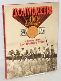
1996réf. 211540New York: International Association of Bridge Structural and Ornamental Iron Workers 1996. Hardcover. vii 297p. glossy pictorial boards profusely illus. very good condition. No dj. International Association of Bridge, Structural, and Ornamental Iron Workers hardcover books
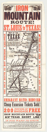
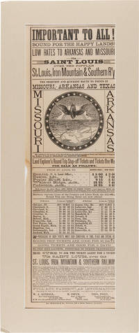
réf. 5718St. Louis: St. Louis Globe-Democrat Job Print; Woodward Tiernan & Hale Map Engr's 1878. Broadsheet with map 20.75" x 6.5" plus margins printed in black and red. Map size 11" x 5". Faded purple stamp of agent Henry H. Hannan. CONDITION: Very good upper-half of right margin rough cut. A scarce and attractive promotional broadsheet with map issued by the St. Louis Iron Mountain & Southern Railway advertising special railway offers to emigrants headed to Texas. This broadsheet announces cheap excursion tickets free baggage up to 200 lbs. and reduced emigrant rates for departures from St. Louis on the Short Line Route which runs through Arkansas into Texas. A table of rates on the verso lists first class and emigrant rates. The Texas Short Line extends from St. Louis Missouri to Galveston and Austin and cuts diagonally across the map with various spurs along the way including intersections the Texas & Pacific R'y and the International & Great Northern R'y. Interested parties seeking assistance information on Texas maps time-tables rates of fare etc. are encouraged to call upon or address the nearest of the railroad's Agents located in Missouri Chicago New York City and Ohio whose names are provided on both recto and verso. The St. Louis Iron Mountain & Southern Railway began selling off land holdings in Arkansas in the mid-1870s and continued to do so into the early twentieth century. OCLC records some twenty maps published by the railroad company promoting land it owned in Arkansas issued during this time period. These lands extended from the northernmost point of the state around Little Rock to the line's southern terminus in Texarkana. The company offered various inducements for settlers deep discounts for putting money down as well as reduced freight should homesteaders wish to transport their belongings via the railway. As demonstrated by the present broadsheet the railroad also capitalized on emigration to Texas. OCLC records only three copies at Yale Princeton and University of Texas at Arlington. St. Louis: St. Louis Globe-Democrat Job Print; Woodward, Tiernan & Hale, Map Engr's, 1878 unknown books
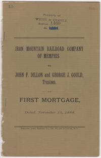
1888réf. 46016N.Y.: Burgoyne Quick Printing Co. 1888. First edition. Stapled paper wrappers. Removed from a larger volume rear wrapper lacking minor soiling and browning ownership stamps and page renumbering in red. 17 pp. Sm. 4to. The Iron Mountain Railroad Company of Memphis was part of Jay Gould's extensive network of Railroads later taken over by his son named in this document George Jay Gould 1864-1923 Stamped on front wrapper & first leaf: Property of White & Kemble who'd published "Atlas and Digest of Railroad Mortgages" at the turn of the 20th century. We could locate no copies of this document in OCLC nor in other online sources. Burgoyne Quick Printing Co. unknown books
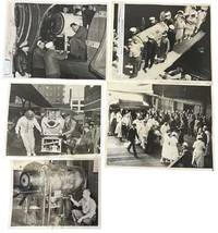
1937réf. 234531937. Iron lung transport press archive documenting the movement of respirator-dependent polio patients through rail terminals ships ramps aircraft hospitals and Coast Guard facilities during the years before the Salk vaccine changed American polio care in 1955. The iron lung developed in 1928 by Philip Drinker and Louis Agassiz Shaw kept patients breathing when polio paralyzed the muscles needed for respiration. Fred B. Snite Jr. appears in several views as the nationally followed Chicago patient who contracted polio in China in 1936 and returned to the United States after a highly publicized 9300-mile medical journey. The group is strongest as a record of medical transport itself: nurses in masks uniformed officers attendants ramps crowds and captioned press slips show how survival could depend on coordinated movement as much as bedside treatment. Photo archive of 5 large silver gelatin press photographs approx 8 x 10 inches Chicago Seattle Port Angeles and related transport locations 1937-1951. Snite's respirator is loaded at a Chicago railroad terminal with his head visible through the front window while men adjust the wheeled carriage; another scene places the iron lung at a ship or dockside ramp surrounded by masked nurses uniformed officers and hospital attendants. A Chicago caption dated February 8 1939 reads "Iron Lung Kid and Bride Entrain for South" identifying Snite and his bride leaving for Miami Florida after their winter vacation. Another verso caption dated June 22 1937 describes his return to Chicago after transport from China where he had been stricken. A January 14 1951 Coast Guard caption identifies an iron lung flown from Seattle to Port Angeles to aid Eldon Tetum a 36-year-old logger stricken with polio. Polio epidemics made the iron lung one of the most visible medical machines of the mid-twentieth century especially before vaccination reduced annual cases after 1955. These scenes connect celebrity medical news to emergency public health logistics showing how mechanical respiration required attendants vehicles terminals aircraft and institutional coordination outside the hospital room. Press stamps pasted captions adhesive staining and surface marks visible on versos; images remain strong and readable. Overall in good condition. unknown books
2004réf. UIROIRO00EFBerkley 2004. Very Good. Iron Chef. Iron Chef: The Official Book. Hoketsu translator Kaoru. New York: Berkley 2004. 312pp. Illustrated. 8vo. Paperback. Book condition: Very good with gently rubbed edges. Berkley paperback books
1717réf. 50277Paris: Guillaume Danet Son-in law of the author 1717. Second edition. Hardcover. Good- to very good condition. Octavo. 197 9pp. 5 folding maps. Original calf with gilt lettering tooling and ruling on spine; raised bands. Decorative endpapers. Title page with copperplate engravings of two hand-colored printed globes and black double-framing California depicted as an island in this and two other maps. Second edition augmented with longitudes and latitudes of major cities. Illustrated headpiece decorative initials and endpieces. All pages with double frames; marginalia. Introduction to geography by the French cartographer and engraver Nicolas de Fer 1646-1720 containing five folding copperplate engraved maps four of them hand-colored. The first showing a general map of the globe with America in one Europe Africa and Australia in the second globe both with North and South Poles. The margins are adorned with hand-colored portraits of significant explorers; Columbus Vespuci Shouten etc. The second map is the only one in black and white. It depicts "La Sphere Artificielle." The third map shows Europe the fourth Asia the Middle-East and Oceania with parts of Europe and Africa and finally North and South America depicted on the fifth. Contains list of cities and catalog of Fer publications at rear. At the age of twelve Fer became an apprentice of the Parisian engraver Louis Spirinx. After the death of Fer's father in 1673 he also was a cartographer Nicolas took over the business specializing in the production atlases geography and cartography-oriented publications. Well connected to the Royal Court Fer advanced to become the official geographer of the Philip V of Spain and Louis XIV of France. His numerous publications are considered artistic rather than accurate. Text in French. Binding rubbed along edges and boards with front joint mostly cracked but holding together. Small plate of previous owner glued to upper inside front cover. Inked and penciled notes on verso of decorative front endpaper. Starting at title page. Some creasing and small closed tears of maps. B/w map with two inch tear reinforced with tape on verso. Map of Europe with four inch closed tear. Map of America also reinforced with three and a half inch paper strip on verso. Page ninety-three with remnants of black glossy paper glued to gutter and part of text some loss of text. Binding in overall good- interior in good to very good condition. Guillaume Danet (Son-in law of the author) hardcover books
1988réf. UCODIND00acmfNaturegraph Publishers 1988. Very Good. Cody Iron Eyes. Indian Talk: Hand Signals of the American Indians. Happy Camp CA: Naturegraph Publishers 1988. 111pp. Illustrated. 12mo. Paperback. Book condition: Very good with rubbed edges. Naturegraph Publishers paperback books
1880réf. 55682St. Louis: Jno. McKittrick & Co. ca.1880. The Shortest and Quickest Route to Points in Missouri Arkansas and Texas An attractive broadside promotional for the St. Louis Iron Mountain & Southern Railway with a large engraving in the center depicting the route from St. Louis through Arkansas and into Texas beneath a train wheel bearing wings about which the motto "Bound for the happy lands" appears all in the center of a circle of stars. A schedule of ticket costs for various routes is included as well as a pitch directed at homesteaders regarding the purchase of government lands. The names of three land agents are listed at bottom - one in Missouri one in Illinois and one in Arkansas. The railway touts their "large grant of lands from the United States Government embracing all varieties of soil and timber adapted to Farming Fruit Growing and Grazing purposes.Immigrants can locate on railroad land in well improved neighborhoods having Roads Mills Churches and Schools and peopled by honest and industrious citizens who will give a cordial welcome to all good people coming among them." Only six copies in OCLC spread over four records located at Yale SMU Michigan the University of Texas at Arlington Truman State and the University of Missouri at St. Louis. Old center horizontal fold small chip to left edge slight wrinkling. Very good. Matted and shrinkwrapped. OCLC 22160865 166641127 702349761 761878887. unknown books
1875réf. 37686St. Louis: The railway Jno. McKittrick & Co. printers St. Louis 1875. Broadside 21 x 7 inches three paragraphs of promotional material ticket office addresses and fare rates set in many typefaces and sizes including display type and illustrated with a circular bird's-eye view map below the heads. Some old staining mostly in margin; "Henry Hannan Land Agent" stamp else very good. Advertising ticket fares and lands for sale to customers in Ohio Michigan Indiana Illinois and Kentucky. OCLC locates two copies Yale Truman State University. The railway (Jno. McKittrick & Co., printers, St. Louis) unknown books
1875réf. 20118New York: J L Mott Iron Works 1875 / 1877. First Editions. The catalog of 1875 is in its original printed limp black cloth gilt stamped publisher's binding; the Supplement is as issued - a printed title wrapper. Both contained within a custom made portfolio with cloth ties. Very good; neatly rebacked; occasional marginal tears; one endpaper with modest chipping at the fore-edge. Folio. 2 132 pp.; Supplement - 8 pp. The catalogs measure appx. 54 x 38 cm. Both are lavishly illustrated throughout; printed on glazed paper. A stunning large format catalog for all kinds of garden ornaments - for public and private use. There are also several pages for stable equipment lamps aquariums garden seating planters etc. Mott was a manufacturer of all kinds of metal goods and plumbing supplies. McKinstry citing only much later printings of smaller catalogs; Romaine p. 258 - citing a much later printing of this garden ornament catalog in the same large format as a "masterpiece". J L Mott Iron Works hardcover books
1970réf. 141943N.p.: N.p. 1970. Draft script for an unproduced film. Text in French. Green untitled wrappers. Title page present with credit for screenwriter Eric Ferro. Xerographic duplication rectos only. Pages Near Fine wrapper Near Fine bound with two silver binder clips. Pagination available upon request. N.p. unknown books
1932réf. 012382St. Louis: Wrought Iron Range Co 1932. Soft cover. Trade catalog 1932 version. Blind- ruled black heavy construction paper- like covers stamped in silver and pink measures approx 6" x 8.5" 223 pages. Detailed promotional catalog for the famous kitchen range and the company founded in 1864. Illustrated showing the evolution of the range from models from 1870 to its most current at the time 1933 and all its sectional parts. Text includes installation requirements chimney exhaust etc hundreds of kitchen recipes and lists of institutional installations of the wrought iron range across the US. Worldcat lists copies of trade catalogs for this company from 1881 through 1951; we could find 7 collections with this 1932 edition. We could find no original copies available anywhere only on-demand or new reprint copies. Covers soiled and the side edge of the rear cover has a short closed tear with some attendant loss. Wrought Iron Range Co unknown books
2016réf. 172042New York: David Zwirner Books 2016. Hardcover. New in shrinkwrap. Cream and color-illustrated boards with black lettering. 179 pp. Color and illustrations. Published to accompany the exhibition held at David Zwirmer New York 2015. David Zwirner Books hardcover books
1996réf. 74970Rome:: Istituto Poligrafico e Zecca Dello Stato. Near Fine. 1996. Hardcover. 8824037968 . Translated from the Italian by Hann Heck and Luciano F. Farina. Color illustrated fold-outs. First edition thus. Near fine in illustrated boards. No dust jacket as issued. . Istituto Poligrafico e Zecca Dello Stato, hardcover books
1831réf. 231927Albany 1831. First. hardcover. very good-. Reports of Committees. On the Product and Manufacture of Iron and Steel. 32pp. Bound with: Proceedings of a Convention of Iron Workers Held at Albany N. Y. on the 12th day of Dec. 1849. 58 2pp. 8vo modern red cloth light foxing a few pages slightly underlined in pencil. New York and Albany 1831 1849. First Editions. unknown books
2016réf. 172920London: Marian Goodman Gallery 2016. Hardcover. VG. Color-illustrated cloth boards with yellow lettering. 264 pp. Color illustrations. Catalog of an exhibition held at Marian Goodman Gallery London June 12 - August 7 2015. Marian Goodman Gallery hardcover books
réf. 218412Paris: Librairie Générale de L'Architecxture et des Travaux Publics Ducher et Cie nd. Missing 6 20 26 30 32 50 83 of 84 plates 2 of plate 22. 2 page of text. 1 vols. Folio. In portfolio. Some foxing to plates else near fine. Missing 6 20 26 30 32 50 83 of 84 plates 2 of plate 22. 2 page of text. 1 vols. Folio. Librairie Générale de L'Architecxture et des Travaux Publics Ducher et Cie unknown books
2015réf. 202075New York: Matthew Marks Gallery 2015. First edition. Hardcover. Exhibition catalog for a show that ran May 13 through June 20 2015. Features an essay by Briony Fer. Includes 12 figures and 21 color illustrations. A fine copy in cloth boards and in a fine dust jacket and with laid in compliments slip. Matthew Marks Gallery unknown books
1970réf. 160429N.p.: N.p. 1970. Vintage borderless oversize color reference photograph from the 1970 film showing actors Jim Brown and Marianna Hill. In 1860s Mexico two men lead a band of Apaches against a fortress said to contain the treasures of Austrian emperor Maximilian. Among the first films to be rated R. Shot on location in Almería Spain. 12 x 9.25 inches. Near Fine lightly curled at the edges. N.p. unknown books
1893réf. 28094London: T. Fisher Unwin 1893. Pseudonym Library edition narrow 12mo pp. 93; original yellow wrappers spine worn and chipped shaken still a good sound copy. Three short stories by the author of Dreams and The Story of an African Farm. T. Fisher Unwin unknown books
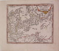
1725réf. 204942Paris: de Fer Nicolas 1725. unbound. very good. Map. Engraving with modern hand coloring. Image measures 5.25" x 6.25". Charming miniature map of Denmark with the Coat of Arms incorporated in the cartouche. Map includes both Schleswig and Holstein while today part of the former and all of the latter are northern Germany. Nicolas de Fer 1646-1720 was a French cartographer engraver and publisher. He became official geographer to the French Dauphin 1691 and to the Spanish King 1702. de Fer, Nicolas unknown books
1953réf. 243802San Francisco: the Brotherhood 1953. Pamphlet. 23p. staplebound booklet 3.5x5 inches very good condition. the Brotherhood unknown books