|
|
|
CROSBIE Jane E.M.
Strangford's Shores. Paintings by Alison Brown. Text by Jane E.M. Crosbie. [Second Impression]. FINE COPY
Oblong 4to., Second Impression, with coloured title-vignette, numerous full-page coloured illustrations and a full-page map in the text; pictorial boards, a fine copy. First published in 1996.

|
|
|
CROSBY Alan
Britain in Old Photographs. Preston.. [Second Edition]. NEAR FINE COPY
8vo., Second Edition, with very numerous photographs in the text; pictorial wrappers, a near fine copy. First published in 1995.

|
|
|
CROSS (Frances W.) & HALL (John R.)
Rambles Round Old Canterbury.
First edition, small 4to (220 x 170 mm), 148, 12pp., illustrs., orig. cloth, gilt.
|
|
|
Cross, M F and Daniel, P A
Lancashire and Cheshire
Ex-library book with minimal markings, limited to neat stamps on title page and reverse only. No other inscriptions or marks. Slight bump to bottom of spine, no other creasing to covers or to spine. A very clean crisp tight copy with unmarked boards. 64pp. This volume is in the British Regional Geographies series with topographical and industrial information on the two counties, along the following geographical chapters, the Coast - Resorts, the Coast - Ports, the Plains, the Pennines, the Lancashire Coalfield, the Mersey Valley and the Cheshire Saltfield and finally Manchester. There are a few exercises on understanding at the end of each chapter Well illustrated with maps, photographs and coloured diagrams and geographical sketches.

|
|
|
CROSSING William
Amid Devonia's Alps, or Wanderings and Adventures on Dartmoor. REMARKABLY BRIGHT, CRISP COPY OF THE ORIGINAL EDITION
8vo., First Edition, with frontispiece, 5 plates, decorative head-and tail-pieces, and patterned endpapers, neat contemporary inscription on front free endpaper verso, preliminaries very lightly spotted; original blue cloth, bevelled boards, upper board and backstrip lettered in gilt and blocked in black and blind, fore-edge lightly spotted, a remarkably bright, clean, fresh copy. With 10pp publisher's catalogue bound in at end. Includes list of tors. VERY SCARCE INDEED IN THIS CONDITION. Brockett 15660; Somers Cocks p.12.
|
|
|
CROSSING William
The Ancient Crosses of Dartmoor and its Borderland. Revised [Second] Edition. Illustrated by T.A. Falcon. 250 COPIES WERE PRINTED
8vo., Second and Best Edition, with frontispiece (original tissue guard present) and 21 plates on 19, wanting folding map, neat signature on half-title; original red ribbed cloth, gilt back, gilt top, uncut, covers mildly age-marked, hinges cracked (but binding still just sound), a good, clean working copy. EDITION LIMITED TO 250 COPIES. This edition of Crossing's definitive study (first edition 1887) contains a number of additional photographs by Falcon. SADLY THIS COPY LACKS THE FOLDING MAP. VERY SCARCE. Brockett 15690; Somers Cocks p.12 (recording the first edition).
|
|
|
CROSSLEY D.
The Fuller Letters. Guns, Slaves and Finance 1728-1755.
8vo., First Edition, with 10 plates; cloth, a fine copy in unclipped dustwrapper.
|
|
|
CROUZET, E.
Eléments de la topographie précédée de notions sur la construction des cartes à l’usage des candidats à l’école de Saint-Cyr. Troisième édition.
Paris, Nony 1894, II - 128pages, reliure demi-basane. Mouillures sur les tranches. Plats papier marbré, auteur et titre dorés au dos. Bon état.
Bookseller reference : 42388
|
|
|
CROYDON
Our Croydon. The Organisation and Activities of the Corporation of Croydon. [With a Foreword by H. Regan, Mayor of Croydon]. BRIGHT, CLEAN COPY
8vo., First Edition, with frontispiece and very numerous photographs (several full-page) in the text; original wrappers printed in blue, covers very lightly age-browned else a very good, bright, clean copy. With the printed errata slip, and two copies of a relevant coloured pamphlet (on Croydon's Water Supply) loosely inserted. Detailed, wide-ranging and well-illustrated account of Corporation activities, including physical setting, war damage, administration, health, education, housing, finance and justice. A fascinating survey of a major town rebuilding itself after the ravages of WWII. VERY SCARCE.
|
|
|
CRULS Ferdinand
Notice historique sur le mètre et la mesure de la terre
32pp., 23cm., br.orig., bon état, rare, W82129
|
|
|
CRULS Ferdinand
Notice historique sur le mètre et la mesure de la terre
Gand, C.Annoot-Braeckman 1889 32pp., 23cm., br.orig., bon état, rare, W82129
Bookseller reference : W82129
|
|
|
Crusius Eberhard (Hrsg.)
Oldenburger Jahrbuch 62. Band / 1963 - umfassend Teil 1 (Teil 2 erscheint als Band 63 für 1964)
Oldenburg (Oldenburger Landesverein für Geschichte, Natur- und Heimatkunde e.V.) 1963 (= Erste Ausgabe). 8°, Originalbroschur ( Paperback ) 319 S., 1 Abbildung, 6 Abbildungen und Karten in Lasche beigelegt 1
Bookseller reference : V39740
|
|
|
CRYSTAL PALACE
Coloured [Auction] Plan of the Crystal Palace 1911. THE CRYSTAL PALACE: A RARE SURVIVAL
Large and elaborate coloured engraved plan measuring approx. 1270mm x 1010mm (50.0 ins x 39.75 ins), folding in 20 panels to approx. 320mm x 210mm (12.5 ins x 8.0 ins); housed in original printed cartridge envelope with self-sealing flap (short tear in flap), A REMARKABLY CLEAN, NEAR FINE COPY. This is an engraved and coloured plan of the Crystal Palace prepared for the intended sale at auction of the buildings and grounds in 1911 (see below). The retaining envelope is printed 'PLAN OF THE CRYSTAL PALACE 1851-1911. Solicitors: Messrs Janson Cobb, Pearson & Company, 22 College Hill, E.C.; Receiver and Manager: Mr. Ernest I Husey (Messrs Jackson, Pixley & Co., Chartered Accountants, 58 Coleman Street, E.C; Auctioneers: Mr. Howard Frank (Messrs Knight, Frank & Rutley), 20 Hanover Sq, London W; and Mr. John Roy Lancaster (Messrs Horne & Co), 85 Gresham Street, E.C.' The plan in well executed and colour-coded to indicate the various leases and tenancies involved. It shows the scale and local context of the magnificent building, together with its world-famous gardens and grounds, including the tiered sculptural terraces, the patios, and the renowned lakes and fountains. Key features such as the Flying Machine, the Maze, Brunel's Polygonal Water Towers, the Lower Lake area housing Waterhouse Hawkins' recreations of dinosaurs (still present today) and the Sports Grounds are clearly highlighted. HISTORICAL CONTEXT. After the Great Exhibition of 1851, the Crystal Palace was re-erected in a considerably enlarged form in 1854 at Sydenham in South London. During the next half century it continued as a major metropolitan tourist attraction attracting visitors from all over the world to marvel at the building, its contents and gardens, and to witness a wide variety of entertainment including music, acrobatics, circuses and fireworks. By the turn of the century, however, the novelty was wearing thin and the number of visitors declined to the point where in 1911 the Palace was declared bankrupt and placed in the hands of a receiver. 'On 28 November it was to be sold by auction, to be offered in one lot as a going concern. This was a fateful period in its history. There was grave danger that it would pass into the hands of the developers. Every jerry builder within striking distance was eager for the moment when he might be in a position to swoop down on the beautiful grounds and reduce them to terms of bricks and mortar. But that ultimate indignity was not to be. The Earl of Plymouth produced £230,000 to buy the Palace as a going concern; at the same time the Lord Mayor of London opened a fund to purchase the Crystal Palace for the nation, and to reimburse Lord Plymouth. This was completed in 1913 and the Crystal Palace was saved.' [A.R. Warwick: The Phoenix Suburb (1972)]. During the Great War the revitalised Palace served as a Royal Naval base (HMS VICTORY VI). At the end of hostilities it became for a short time the home of the Imperial War Museum and then reverted to tourism with exhibitions of early flying, pioneer television, dirt-track racing, music festivals, dog and cat shows, dancing and fireworks. In this way it continued until completely destroyed by the tragic fire of 30 November 1936 - the end of a great era. IT IS UNCERTAIN HOW MANY OF THESE ELABORATE PLANS WERE PRODUCED, BUT THE NUMBER CANNOT HAVE BEEN GREAT. GIVEN THAT £230,000 (VERY APPROXIMATELY £7M BY TODAY'S STANDARDS) WAS REQUIRED TO OBVIATE THE NEED FOR SALE, THE NUMBER OF INTENDING BIDDERS MUST HAVE BEEN FEW INDEED. IN ANY CASE IT IS UNLIKELY THAT MANY COPIES SURVIVE, ESPECIALLY IN THIS VIRTUALLY UNOPENED STATE COMPLETE WITH ORIGINAL ENVELOPE. A DOCUMENT OF CONSIDERABLE SIGNIFICANCE IN THE HISTORY OF SOUTH LONDON, AND A VIVID REMINDER OF ONE OF LONDON'S GREATEST HISTORIC ATTRACTIONS.
|
|
|
création du Cadastre: Directives du ministre adressées au préfet NOMPERE DE CHAMPAGNY (Jean-Baptiste de).
CADASTRE DE LA FRANCE.Le préfet du département de l'Ardêche, vu la lettre de son Excellence le ministre de l'Intérieur, sous la date du 13 mars dernier, dont la teneur suit: [...] J'ai mis monsieur, sous les yeux de l'Empereur, des observations sur les principes que vous avez suivis jusqu'à présent pour la délimitation des communes, pour la confection du Cadastre. [...](suivi des arrétés de préfet de l'Ardèche): Les conseils municipaux des communes de Pradons et de Balazuc, de la Chapelle, de St-Maurice-d'Ardêche, de Rochecolombe, de Planzolles, de Faugères, de St Germain et de Vogüé, et toutes autres communes dont les limites auraient été modifiées [...] se runiront [...] à l'effet de délibérer sur les changemens à opérer[...] en l'absence du préfet, signé "Defrances"
A Privas, imp. Guiremand, 1806, 1 en cahiers. in-4 de 10 pp. ;
Bookseller reference : 14015
|
|
|
CUBBON (William) Compiler and Editor.
A Bibliographical Account of Works Relating to the Isle of Man. With Biographical Memoranda and Copious Literary References.
First Edition, 2 vols., [viii],747; [viii],[749]-1536pp., plates and facsimiles, orig. cloth. Some of the subjects covered include Manx language and literature, poetry and drama, prose fiction, periodicals and journalism etc.
|
|
|
CUDWORTH W.
Histories of Bolton and Bowling. (Townships of Bradford) historically and topographically treated. Published by Subscription.
8vo., First Edition, on laid paper, with an etched portrait frontispiece (original tissue guard present), 19 plates (all tissue guards present), 9 illustrations (a number full-page) in the text, 6 large folding pedigrees on India Paper and several full-page pedigrees in the text, some very minor spotting; original decorative half calf gilt, neatly rebacked in calf to style, original leather label laid down, gilt top, uncut, new endpapers to style, a very good, bright, clean copy. Uncommon.

|
|
|
CUDWORTH W.
Round about Bradford. A Series of Sketches (descriptive and semi-historical) of Forty-Two Places within Six Miles of Bradford.
8vo., First Edition, with folding geological section but wanting the map which is often missing, extensive and detailed contemporary annotation to blank leaf facing title, title, pp. 352-3 and elsewhere in text, and rear free endpaper, top lightly spotted; original red cloth, gilt back, green endpapers, backstrip mildly sunned, upper hinge cracked (but text block entirely sound) else a good, clean working copy. The extensive annotations relate primarily to the family of Yewdell of Eccleshill.

|
|
|
CUDWORTH W.
Round About Bradford. A Series of Sketches, Descriptive and Semi-Historical, of Forty-Two Places within Six Miles of Bradford.
8vo., First Edition, with a folding coloured plan and large folding map; original brown cloth, very neatly rebacked with old backstrip gilt laid down, a very good, bright, clean copy. Very scarce, especially in this condition
|
|
|
CUNCLIFFE Barry
The Roman Site at Fishbourne. An Interim Report on the 1962 Excavations. BRIGHT, CLEAN COPY
8vo., with 14 plates on 4; original printed wrappers, wire-stitched as issued, lower blank corner missing else a bright, clean copy. Sold from an institution with its neat stamp on first page of text. The Chichester Papers, No. 32.

|
|
|
CUNDALL H.M.
Bygone Richmond.
4to., First and Sole Edition, with a coloured frontispiece and 46 monochrome plates (one folding) on 39, some light occasional foxing (rather heavier on margins of two text leaves in the Introduction) as often; original paper boards, holland back gilt, uncut, a very good, crisp, firm copy. Uncommon, especially in this condition.
|
|
|
CUNLIFFE Barry
Excavations at Fishbourne 1961. First Interim Report. BRIGHT, CLEAN COPY
4to., with 8 plates on 4, plans and diagrams in the text and 2 large folding plans, small neat signature on front wrapper; original printed wrappers, wire-stitched as issued, a very good, clean copy. Reprinted from The Antiquaries Journal, Vol. XLII, Part I, 1962.

|
|
|
CUNLIFFE Bruce
Excavations at Fishbourne 1961-1969. Vol. I: The Site; Vol. II: The Finds. COMPLETE SET IN DUSTWRAPPERS
2 vols., 4to., First Edition, with plates; cloth, gilt backs, a very good, bright, clean set in price-clipped dustwrapper, the latter lightly chafed at edges.
|
|
|
CUNLIFFE Bruce
Excavations at Fishbourne, 1961. First Interim Report. NEAR FINE COPY
4to. with plates and three plans (2 folding); printed wrappers wire-stitched as issued a near fine copy. Offprinted from The Antiquaries Journal vol. XLII Part I.
|
|
|
Curioni Giovanni
Corso di topografia ad uso delle scuola d'applicazione e delle scuola universitarie per gl'ingegneri ... utile agli uffiziali dell'esercito, agli impirgati del genio civile e del catasto. Testo e Tavole
<p>25 cm, 2 volumi legati assieme, (testo e tavole), rilegatura in mezza pelle, titolo e fregi in oro al dorso; P. 372; (2), 36 tavole a piena pagina. Timbro privato al frontespizio, Un angolo del piatto contuso</p>
|
|
|
Curioni Giovanni
OPERAZIONI TOPOGRAFICHE(1874)
Due tomi in un unico volume, in 8 gr. leg. mz. pelle con filetti e tit. in oro al dorso e piatti marmorizzati, pp. 470, XXXII tav. f.t. +7 indice delle figure.Volume in ottimo stato, ordinari segni del tempo, fioriture, alcune carte brunite;Luogo di pubblicazione TorinoEditore NegroAnno pubblicazione 1874Collana L'Arte di fabbricare ossia Corso Completo di Istituzioni Teorico-PraticheMateria/Argomento Topografia, Architettura, Ingegneria

|
|
|
CURIONI, Giovanni
Corso di topografia.
In-8°, pp. 7, 470, XXXII tavv. f.t., legatura coeva in mezza tela, titolo e fregi in oro al dorso.

|
|
|
CURRADI Currado -
Annotazioni sul territorio Faventino acto Corneliensi.
Faenza, 1991, 8vo stralcio con copertina posticcia muta, pp. 15/42 con 2 cartine. - !! ATTENZIONE !!: Con il termine estratto (o stralcio) intendiamo riferirci ad un fascicolo contenente un articolo, completo in se, sia che esso sia stato stampato a parte utilizzando la stessa composizione sia che provenga direttamente da una rivista. Le pagine sono indicate come "da/a", ad esempio: 229/231 significa che il testo è composto da tre pagine. Quando la rivista di provenienza non viene indicata é perché ci è sconosciuta. - !! ATTENTION !!: : NOT A BOOK : “extract” or “excerpt” means simply a few pages, original nonetheless, printed in a magazine. Pages are indicated as in "from” “to", for example: 229/231 means the text comprises three pages (229, 230 and 231). If the magazine that contained the pages is not mentioned, it is because it is unknown to us.

|
|
|
CURRIE C.R.J.
A Guide to English County Histories.
4to., First Paperback Edition, with a frontispiece and 25 plates; original printed wrappers, a near fine copy. An important and extremely useful study which, in addition to its historial and bibliographical surveys of the counties, includes a moving tribute by Susan Reynolds to Christopher Elrington, general editor of the Victoria County History.

|
|
|
CURTIS (Rev. John)
A Topographical History of the County of Leicester, the Ancient part compiled from Parliamentary and other Documents, and the modern from Actual Survey: Being the first of a series of the Counties of England and Wales, on the same plan.
First edition, small 4to (260 x 160 mm), xliv, 227, [1]pp., LARGE PAPER COPY, Dr. W. G. Hoskins copy, double-page coloured map of Leicestershire before the title (linen-backed with extra large margin), original blue cloth, hinges frayed in places, printed paper label on spine, uncut, a firm clean copy.
|
|
|
CURTIS Peter
In Times Past. Wood Green and Tottenham with West Green and Harringay. An Illustrated Journey into more peaceful life styles. [Third Edition]. FINE COPY
8vo.,Third Edition, with numerous photographs in the text; original photographic wrappers, a fine copy. Augmented version of the editions of 1991 and 1992.

|
|
|
Curty, C & MEYER, J. H.:
Gryers (Gruyère) im Canton Freyburg, gegen Osten.
(1810), 13.5x8.7 cm Gravure sur cuivre originale. / Tirée de : - Helvetischer Almanach für das Jahr 1810. 1 feuille / Blatt / sous passepartout
Bookseller reference : 145.1aaf
|
|
|
CURTY, C & MEYER, J. H.:
Gryers (Gruyère) im Canton Freyburg, gegen Osten.
(1810), 13.5x8.7 cm Gravure sur cuivre originale. / Tirée de : - Helvetischer Almanach für das Jahr 1810. 1 feuille / Blatt / sous passepartout
Bookseller reference : 132003aaf
|
|
|
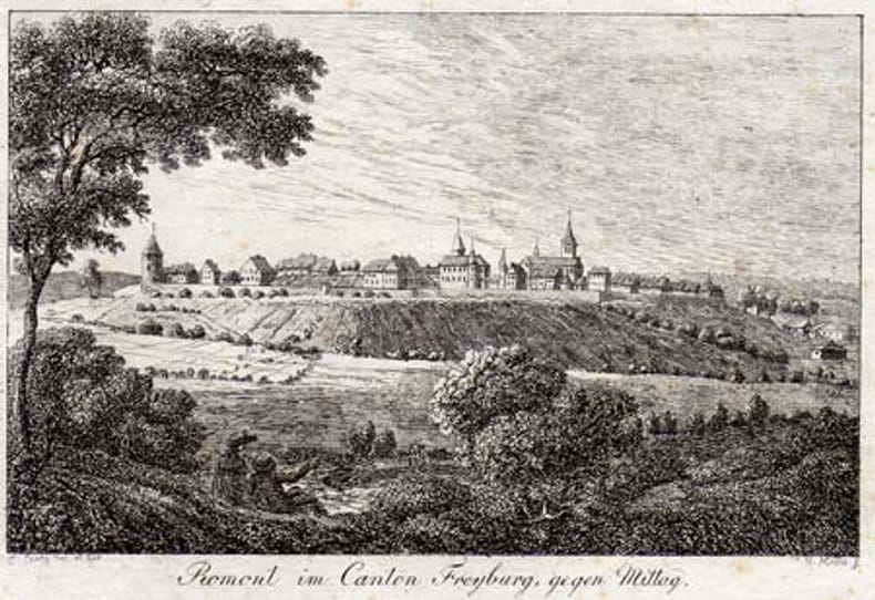
CURTY, C del. & MEYER, J.H. fec.:
Romont im Canton Freyburg, gegen Mittag.
vers 1810, 8.5x13.4 cm, Gravure sur cuivre originale légères rousseurs / Kupferstich aus Kuenlin: Helvetischer Almanach für das Jahr 1810, 1 feuille / Blatt (13.2x19.4 cm).
Bookseller reference : 100309aaf
|
|
|
CURTY, C del. & MEYER, J.H. fec.:
Romont im Canton Freyburg, gegen Mittag.
vers 1810, 8.5x13.4 cm, Gravure sur cuivre originale qqs rousseursK 1 feuille / Blatt (13.2x19.4 cm).
Bookseller reference : 105895aaf
|
|
|
CURWEN E. Cecil
The Archaeology of Sussex. [Second and Revised Edition.] NEAR FINE COPY OF THE REVISED AND BEST EDITION
8vo., Second Edition, with plates, and illustrations and maps in the text; blue cloth, gilt back, blue top, a near fine copy. Revised and expanded version of the original edition of 1937.
|
|
|
CYCLING & MOTORING MAP OF EXETER DISTRICT
Bacon's Cycling and Motoring Map of Exeter District[Cycling and Touring] Map of 60 Miles South of London, including Worthing, Brighton, Hastings, etc.. Scale Half an Inch to One Mile. NEAR FINE COPY
8vo., folding map on cloth, coloured in outline, measuring 15 x 20 inches (approx. 38 x 51 cms) folding in 18 panels to 5.25 x 3.5 inches (approx. 13 x 9 cms); red limp cloth wrappers lettered in black, radial corners, a near fine copy. With trade advertisements. SCARCE IN THIS CONDITION.
|
|
|
CYCLING & TOURING MAP 60 MILES SOUTH OF LONDON.
[Cycling and Touring] Map of 60 Miles South of London, including Worthing, Brighton, Hastings, etc.. Scale Half an Inch to a Mile. NEAR FINE COPY
8vo., folding map on paper, coloured in outline, measuring 30 x 25 inches (approx. 76 x 64 cms) folding in 48 panels to 6.5 x 3.5 inches (approx. 16 x 9 cms); green limp cloth wrappers lettered in red and black, radial corners, backstrip lettered in black, a near fine copy. With the small trade ticket of H.J. Ryman of Oxford Street on front inner wrapper. EXTREMELY SCARCE IN THIS CONDITION.
|
|
|
Czajka, Willi
Der Schlesische Landrücken. Eine Landeskunde Nordschlesiens. 2 Bde. Zweite, erweiterter Aufl.
Wiesbaden, Steiner Verlag 1964. OPp. VII, 156 S. 17 Bll. (Taf.); XVI, 422 S. 10 Bll. (Taf.) Gr.-8°. Mit zahlr. Abb. Softcover/Paperback, Einband bräunlich, sonst Exemplar in gutem Erhaltungszustand
Bookseller reference : 34085

|
|
|
Czeike, Felix
Historisches Lexikon Wien in 5 Bänden und Band 6 Ergänzungsband. Abweichender Titel des Ergänzungsbandes: Historisches Lexikon Wien in 6 Bänden.
Wien, Kremayr & Scheriau, 1992-1997, 2004 (Ergänzungsband). zahlreiche Textabbildungen, 623, 652, 700, 708, 764, 250 S., 6 Bände. Original-Leinenbände (weiß) mit schwarzgeprägtem Deckeltitel auf rotem Schild und geprägtem schwarz-rotem Rückentitelschildchen, Original-Schutzumschlag (OU/SU) (weiß-orange) mit schwarz-goldenem Deckel- und Rückentitelschildchen. ZUSTAND -1, Rücken der ersten 3 Bände NICHT wie immer farbbedingt ausgebleicht.
Bookseller reference : E0026
|
|
|
Czerny, Franz
Die Wirkungen der Winde auf die Gestaltung der Erde. Ein Streifzug im Gebiete der physikalischen Geographie. [Hrsg.:] Petermann, August. [Mittheilungen [Mitteilungen] aus Justus Perthes' Geographischer Anstalt über wichtige neue Erforschungen auf dem Gesammtgebiete [Gesamtgebiete] der Geographie. Ergänzungsheft. Nr. 48].
Gotha, Justus Perthes 1876. 4°. 53 pp., 1 kolorierte Karte in Folio [So komplett]. Neuere Interimsbroschur. Vom Schnitt her etwas angestaubt.
Bookseller reference : 6045965
|
|
|
D'Ambrosio, Antonio - Borriello, Mariarosaria
Baiae-Misenum.
cm. 24,5 x 34, 182 pp. con 391 ill. n.t., 10 tavv. f.t. di cui 6 ripiegate e 1 carta ripiegata a due colori. Forma Italiae - Serie I 1305 gr. 182 p.
|
|
|
D'Angelis Erasmo
La conquista dell'acqua. Dai laghi preistorici alla gestione del bene comune
ill., ril. Una guida corredata di immagini per entrare nel complesso e affascinante mondo dell'acqua, facendosi sorprendere dalla storia idrica del nostro territorio, in gran parte sconosciuta. Scritto in occasione del decimo anniversario della nascita di Publiacqua, l'azienda pubblica più grande della Toscana, il volume si muove su tre livelli, con l'obiettivo di raccontare il passato, descrivere il presente e far immaginare il futuro. Il lettore scoprirà che differenza c'è fra l'acqua dei laghi preistorici che coprivano la piana occupata oggi da Firenze, Prato e Pistoia e quella che esce dai rubinetti delle case o dai fontanelli nei parchi. Oppure cos'è cambiato da quando scorreva nei canali scavati dagli etruschi o lambiva i ponti romani, azionava i mulini medievali o zampillava nei giardini dei Medici. Leggerà infine la storia delle straordinarie trasformazioni ambientali e urbanistiche, culturali e sociali attraverso la chiave di lettura dell'acqua, i suoi usi per la vita e la sua potenza distruttiva, il faticoso passaggio dalle prime, rudimentali opere all'attuale moderna gestione integrata.

|
|
|
D'Angelis Erasmo
Tevere nostrum. Acqua, storia, natura, cultura
ill., cart. Il Tevere, laddove nasce, "è ancora poco più che un'idea" ma poi, con i suoi 405 km di corso, diventa il terzo fiume italiano per lunghezza e portata: partendo dal monte Fumaiolo, attraversa l'estremità orientale della Toscana, l'Umbria e il Lazio, bagna Roma per tuffarsi infine nel mar Tirreno. Arricchito da un florilegio di immagini suggestive, il volume narra la storia dei popoli che dall'alba dei tempi hanno condiviso le sorti e il territorio con il grande Tiber, e degli esseri viventi, animali e vegetali, che hanno animato e animano tutt'oggi le acque e le sponde del fiume. Si sofferma su aneddoti e verità dimenticate, traccia percorsi da sperimentare in prima persona, scova e rivela segreti nascosti in pagine di memorie lontane, e descrive le grandi opere di ingegneria - acquedotti, fognature, ponti, porti e fontane - di cui furono artefici prima gli Etruschi e poi i Romani. Nomi e numeri di una storia millenaria che, insieme al resoconto della continua lotta dei nostri antenati per la sopravvivenza tra piene, alluvioni e malaria, racconta l'indiscusso debito di Roma caput mundi nei confronti delle acque tiberine.

|
|
|
D'ANTONA Mario -
Un aereo militare americano che volava fra le nubi a 3000 metri sopra il vulcano di Mauna Loa nelle isole Haway, allo scopo di fare dei rilievi topografici, è stato investito dalla colonna centrale di fumo e, inghiottito dalla corrente calda, si incendiava.
Milano, 1949, 23 gennaio, copertina illustrata a colori in fascicolo originale completo di, pp. 16 de “Illustrazione del Popolo" .

|
|
|
D'Apostoli Roberto
Manuale di topografia
brossura Questo manuale di topografia è frutto di una lunga esperienza professionale ed editoriale dell'autore; esso si propone, pur nella sua sinteticità, come un valido riferimento per gli operatori del settore, esponendo gli argomenti più usuali come: il rilievo topografico, attraverso la descrizione delle sue fasi e delle strumentazioni di impiego, quali il teodolite ottico-meccanico e elettronico, la stazione totale, il livello ottico-meccanico e digitale, il sistema di posizionamento GPS, precisando le tecniche operative; il rilievo fotogrammetrico, con particolare riguardo all'aerofotogrammetria ed alle strumentazioni ad essa funzionali. Si fa cenno anche al Telerilevamento, nonché al Rilievo dei vicini e ai GIS. Le applicazioni topografiche, comprendenti l'Agrimensura e le Sistemazioni superficiali dei terreni (Spianamenti) sono trattate in maniera esauriente. Conclude il volume un breve Glossario di Topografia, per dare la possibilità di orientarsi nella "giungla" di parole e acronimi, ormai entrati nella normalità della comunicazione tecnica.

|
|
|
D'Apostoli Roberto; Giampaolo Francesco
Guida pratica al rilievo topografico con GPS e stazione totale
br. La necessità di proporre una guida deriva dall'improvvisazione che molte volte si rileva nell'ambito delle operazioni di rilievo topografico anche per estensioni di 200 m di raggio, in particolare da quando le apparecchiature sono alla portata economica di un pubblico numeroso. Il neofita, pur se provvisto di strumentazione all'avanguardia, tende a sottovalutare o addirittura a ignorare i concetti basilari che devono regolare il suo lavoro, concetti da cui non si può mai prescindere, pena la improponibilità del lavoro eseguito. La tecnologia infatti, anche se appare di facile impiego, non dà la minima certezza della bontà del risultato finale, che deve essere garantito da studiati e consolidati criteri; questi ultimi debbono essere l'indispensabile bagaglio di qualsiasi operatore. Il volume è articolato in due parti; nella prima parte si ricordano i concetti informatori della topografia, come: le superfici di riferimento e i riferimenti; le reti geodetiche e le reti GNSS; il rilievo topografico e le sue parti: ricognizione, misure di campagna con Stazione Totale e GPS (descrizione dei due strumenti e modo di operare), il calcolo, la restituzione (piano quotato, DTM, piano a curve di livello, lettura delle mappe), la post-ricognizione; nozioni di cartografia (Carta d'Italia IGMI, Cartografia Tecnica Regionale e cenni sulla Cartografia Catastale). Nella seconda parte si espongono dettagliatamente tre esempi professionali di rilievo, eseguiti con la Stazione Totale, con il GPS e con il GPS e Stazione Totale. Completa la trattazione un dizionarietto tecnico per un primo orientamento nella moltitudine di nomi e acronimi che interessano il rilievo.

|
|
|
D'ARRIGO Agatino -
Bocca d'Arno in un Codice Vinciano ritrovato alla Biblioteca Nazionale di Madrid.
Firenze, 1969, 8vo stralcio con copertina posticcia muta, pp. 558/562 con una tavola fotografica. - !! ATTENZIONE !!: Con il termine estratto (o stralcio) intendiamo riferirci ad un fascicolo contenente un articolo, completo in se, sia che esso sia stato stampato a parte utilizzando la stessa composizione sia che provenga direttamente da una rivista. Le pagine sono indicate come "da/a", ad esempio: 229/231 significa che il testo è composto da tre pagine. Quando la rivista di provenienza non viene indicata é perché ci è sconosciuta. - !! ATTENTION !!: : NOT A BOOK : “extract” or “excerpt” means simply a few pages, original nonetheless, printed in a magazine. Pages are indicated as in "from” “to", for example: 229/231 means the text comprises three pages (229, 230 and 231). If the magazine that contained the pages is not mentioned, it is because it is unknown to us.

|
|
|
D'Avezac
L'Univers. Histoire et Description de Tous les Peuples. Iles de l'Afrique par M. d'Avezac, avec la collaboration de MM. de Froberville, Frederic Lacroix, Fd. Hoefer, Mac Carthy, Victor Charlier. 4 parties en 1 volume.
Paris, Firmin Didot Freres, 1848. 2 Bl., 126 Seiten, 1 Bl., 8 gestochene Tafeln, 191 (1) Seiten, 41 gest. Tafeln, 300 Seiten, IV, 179 Seiten, 20 gest. Tafeln; zusammen 69 Tafeln (=compl.). Halbleinenband der Zeit., afrique >L'Univers. Histoire et Description de Tous les Peuples<
Bookseller reference : 11466BB

|
|
|
D. G.M.
James Cross. Vicar of the Peculiar of Sturminster Marshall, 1877-1931. A Sidelight by G.M.D. [Gerald Marchant Davis.] NEAR FINE COPY
8vo., First Edition, on laid paper, with portrait frontispiece and plates; black cloth, upper board blocked and lettered in gilt, gilt back, uncut, a near fine copy. VERY SCARCE.
|
|
|
Dacho, Manfred
Die Stadt Gmünd in der Zweiten Republik. 2., erweiterte Auflage.
Weitra, BdP 2008. quer-gr.-8°. 477 S., zahlr. s/w Abb., ill. OPappband, neuwertig.
Bookseller reference : AUST2006
|
|
|
 Receive by email
 Download as PDF document
 RSS feed


