|
Europa Medii Aevi. Europa im Mittelalter.
o. O. u. J. (um 1830). Kupferst.-Karte, 23 x 23 cm. Titel in Kartenmitte oben. Mit Meilenzeiger. Größere ausgeschnitt. Stelle (ca 3 x 9,5 cm) im li. w. Rand. Einige schwache Stockfl.
Bookseller reference : KART0033

|
|
|
Europäische Türkei: Rumelien, Bulgarien und Walachei 1850. Grenzkolor. Stahlstich-Karte des Bibliographischen Instituts, Hildburghausen u.a. (18,5 x 25 cm)
o.J.
Bookseller reference : 38543AB
|
|
|
Europäische Türkey. Randkolor. Kupferstichkarte. 40,3 x 29,3 cm. um 1810.
o.J. Einige Städtenamen mit Tusche unterstrichen.
Bookseller reference : 39170AB
|
|
|
Europäisches Russland. Randkolorierte Kupferstichkarte von 4 Platten. 57 x 78 cm. In der Platte mit Signatur "C.P.S.C.R.A.M." (Cum Privilegio Sacrae Caesareae Regiaeque Apostolicae Majestatis) u. "S.B.V. Adm. 15 Kr. W. W."
Wien um 1810. Braunfleck (10 x 4 cm) mit leichtem Abklatsch auf gegenüberlieg. Seite, sonst leichte Stockflecken. Gefaltet.
Bookseller reference : 39186AB
|
|
|
Europäisches Russland. Entw. u. gez. v. Hauptmann Radefeld. 1844. Gestochene, grenzkolorierte Karte 35,5 x 30 cm. (aus Meyer's Handatlas, Nr.43)
Hildburghausen, Amsterdam u.a. Bibliogr. Institut 1844.
Bookseller reference : 39135AB
|
|
|
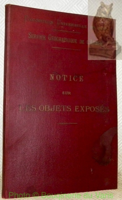
Exposition Universelle de 1900. Ministère de la Guerre. Service géographique de l’armée. Notice sur les objets exposés. (Instruments et cartes).
Paris, 1900, 260x160mm, 43pages, reliure d'éditeur. Plats supérieur taché.
Bookseller reference : 29366
|
|
|
Fahrplan der Lauenburger Dampfschiffe. Leporello gefaltet. Mit 1 farb. Plan von Hamburg bis Gorleben, gesäumt von 13 s/w. Ansichten.
(Lauenburg, 1927). Gefalzt zu 12 S. Verso Fahrplan u. Anzeigen in Braundruck (22 x 9,5 cm).
Bookseller reference : 71730

|
|
|
Falk-Plan Hamburg : Große Ausgabe [No. 105]. 40. Aufl.
Hamburg, Falk-Verlag, 1965. Farbiger Straßenplan mit Patentfaltung in Hyperboloid-Projektion mit Kilometernetz. Im gleitenden Maßstab 1:25.000-1:35.000. Mit 59 S. Straßenverzeichnis. (= Euro-Serie). Blattmaß 58,5 x 83 cm. Deckel 21 x 11,5 cm. OKart.
Bookseller reference : 87189

|
|
|
Falk-Plan Hamburg : Großraum Hamburg [No. 102]. 32. Aufl. (Ausgabe 1991/92). Mit Aktualitäts-Siegel.
Hamburg, Falk-Verlag, 1991. Farbiger Straßenplan mit Patentfaltung in Hyperboloid-Projektion mit Kilometernetz. Im gleit. Maßstab 1:17.000-1:40.000. Mit 82 S. Straßenverzeichnis u. Schnellbahnnetz. Blattmaß 82 x 116 cm. Deckel 23,5 x 13 cm. OKart.
Bookseller reference : 71281

|
|
|
Falk-Plan Hamburg : Großraum Hamburg [No. 489] Megaplan. [1. Aufl.]. (Ausgabe 1994/95). Mit Postleitzahlen.
Hamburg, Falk-Verlag, 1994. 5 Karten-DoppelS. (Hauptkarte: Hyperboloid-Projektion mit Kilometernetz, gleitender Maßstab 1:22.000-1:38.000. Mit 109 S. Straßenverzeichnis (mit Adressen u. Hinweisen). Blattgröße 95 x 108 cm. Deckel 24 x 11,5 cm. OKart.
Bookseller reference : 71279

|
|
|
Falk-Plan Hamburg : Großraum-Stadtplan [No. 102]. 31. Aufl. (Auflage 1991). Mit Aktualitäts-Siegel. Wedel, Schenefeld, Pinneberg, Ellerbek, Quickborn, Norderstadt, Ahrensburg, Grosshansdorf, Oststeinbek, Glinde, Reinbek, Wentorf, Meckelfeld, Neu-Wulmstorf, Seevetal.
Hamburg, Falk-Verlag, 1990. Farbiger Straßenplan mit Patentfaltung in Hyperboloid-Projektion mit Kilometernetz. Im gleit. Maßstab 1:17.000-1:40.000. Mit 75 S. Straßenverzeichnis u. Schnellbahnnetz. Blattmaß 82 x 116 cm. Deckel 23,5 x 13 cm. OKart.
Bookseller reference : 71280

|
|
|
Falkplan Megaplan Hamburg No. 489. Mit Postleitzahlen. 2. Aufl.
(Hamburg, Falk-Verlag, 1996). Mehrf. gefalt. farbiger Straßenplan in Hyperboloid-Projektion mit Kilometernetz im gleitenden Maßstab 1:22.000 - 1:38.000, 1 Übersichts-Kte., verso Innenstadtplan im Maßstab 1:12.500. Mit 96 S. Straßenverzeichnis, Adressen, Verkehrslinien. Blattmaß 95 x 108 cm, Deckelmaß 24 cm. OKart.
Bookseller reference : 69712

|
|
|
FINE ART VIEWS OF LONDON with descriptive notes
G (no dj, maroon mock snakeskin grained cloth with bright gilt illustration and titles front board, worn and rubbed spine edges and corners, few light surface cracks and abrasions, internally in very good condition with one tiny spot title page else pages clean and unmarked) large octavo extended landscape 48pp. No date of publication but includes photo of Bush House, Kingsway, erected 1922. 48pp of b/w photographs printed on glossy art paper.
|
|
|
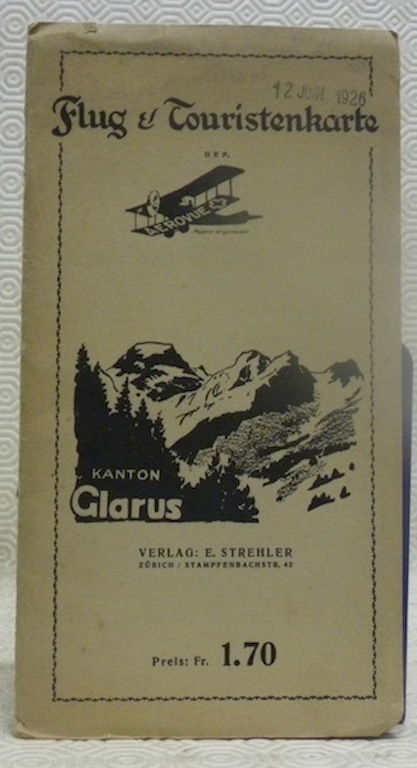
Flug & Touristenkarte DEP. Kanton Glarus.
Zürich, Verlag E. Strehler ohne Jahr, ca. 1930 205x125mm, 470x655mm,
Bookseller reference : 69487
|
|
|
Foopass 1:50 000 Carte topographique de la suisse. Ueberdruck.
Berne, Service topographique fédéral, 1908, in-8vo, 19x13 cm pliée, 18 segments, carte pliée blanche.
Bookseller reference : 107230aaf
|
|
|
Foopass. 1:50 000. Topographischer Atlas der Schweiz.
Bern, Eidg. Landestopographie, o.J. (um 1900), in-8vo, gefaltet, 1 gefaltete Karte, in 18 Segmenten auf Leinen aufgezogen, mit Stempel ‘Verkaufspreis Fr. 3,70.-’, Titelblatt vorne u. hinten in blau mit schematischer Darstellung.
Bookseller reference : 107195aaf
|
|
|
Foopass. 1:50 000. Topographischer Atlas der Schweiz.
Bern, Eidg. Landestopographie, o.J. (um 1900), in-8vo, gefaltet, 1 gefaltete Karte, in 18 Segmenten auf Leinen aufgezogen, mit Stempel ‘Verkaufspreis Fr. 5,40.-’, Titelblatt vorne u. hinten in blau mit schematischer Darstellung.
Bookseller reference : 107207aaf
|
|
|
Fotogrammetria. Impiego dello Stereoautografo Orel
Buono stato, bross. spillata, in-4, 34 pp e una tav. ripiegata, macchioline e ingialliture

|
|
|
France-West Coast the Channels beetween Ushant and the Mainland. from the Pilot Francais 1818 with corrections and additions to 1935. 1:46 400). London Published at the Admirality .Sheet70x103 cm. copyright 1970
1935 70x103 cm.
Bookseller reference : 2047.1aaf
|
|
|
Franckenland in Germania. Karte aus Sebastian Münster (um 1580). Holzschnitt. 9,5 x 13,6 cm. - Region von Nürnberg bis Frankfurt, Fulda bis Rothenburg.
o.J.
Bookseller reference : 27191AB
|
|
|
Franconia vulgo Franckenlandt. Altkolorierte Kupferstich-Karte v. Guilielmus Blaeu. Rückseitig Text (Niederländisch) (38 x 50 cm) ca. 1650.
o.J.
Bookseller reference : 38468AB
|
|
|
Franconia. Altkolor. Kupferstichkarte (42 x 51, Druck) Edinburgh, Lizars, um 1820.
o.J.
Bookseller reference : 46386AB
|
|
|
Franconia. Franciae Orientalis (vulgo franckenlant) descriptio auctore Sebast. a Rotenhan. Altkolor. Kupferstichkarte aus Taschenaltlas von Abraham Ortelius (1589) 7,6 x 10,5 ( Platte)
o.J.
Bookseller reference : 47629AB
|
|
|
Franconiae nova descriptio. Sumptibus Jansonio Waesbergiorum, Mosis Pitt et Stephani Swart. Kupferstich-Karte (41,5 x 53 cm) von Nicolaus Ritterhaus, Amsterdam bei Johannes Janssionnius. um 1650.
o.J.
Bookseller reference : 38466AB
|
|
|
Franconiae nova descriptio. Sumptibus Jansonio Waesbergiorum, Mosis Pitt et Stephani Swart. Altkolor. Kupferstich-Karte (41,5 x 53 cm) mit Titel- und Wappenkartusche, sowie Meilenzeiger von Nicolaus Ritterhaus, Amsterdam bei Johannes Janssionnius. um 1650.
o.J. - hinter Glas gerahmt!
Bookseller reference : 44101AB
|
|
|
Franconie Bohemiae pars. Kupferstich-Karte von Nicolas de Fer, 1697.18,3 x 25 cm
o.J.
Bookseller reference : 38722AB
|
|
|
Franken. - Teilstück der großen Schwaben-Karte von Homann bei J. A. Pfeffel. Nürnberg um 1750. Flächen- und randkoloriert. (48 x 78,5 cm.)
o.J. - Stempelung am unt. rechten Eck.
Bookseller reference : 41905AB
|
|
|
Frankfurt / M. - Stahlstich v. C. Lindemann. Ansicht mit belebtem Mainkai. 10,2 x 14,9 cm. um 1850. - etwas stockfleckig.
o.J.
Bookseller reference : 31051AB
|
|
|
Frauenfeld 1:100 000 Carte topographique de la suisse. Ueberdruck.
Berne, Service topographique fédéral, 1910, in-8vo, 19x13 cm pliée, 18 segments, carte pliée blanche.
Bookseller reference : 107225aaf
|
|
|
Freising. - "Die Bischoffliche Statt Freysingen im Beyerland zwischen Landshut und München gelegen" Holzschnitt aus Sebastian Münster. ca. 1580. 13 x 36 cm.
o.J.
Bookseller reference : 27096AB
|
|
|
Fremden-Führer durch die grüne Steiermark.
(Graz ?), J. Pacher & Co, 1929. 55 nn. Bll. (Text), 15 nn. Bll. (Anzeigen) mit zahlr. Textabb. 8°. OHLwd. (Gebrssprn.).
Bookseller reference : 18781

|
|
|
Fribourg autre aspect. Vue de la Ville de Fribourg (en Suisse) (Ansicht der Stadt Freiburg in der Schweiz).
s.d. ca. 1860, 16.3x24.3 cm l'image. Xylographie, 1 feuille 26.5x36.5cm.
Bookseller reference : 647.1aaf
|
|
|
Fribourg by night, Fotoposter 51.5x70 cm.
Bookseller reference : 1764.1aaf
|
|
|
Fribourg. Gravure sur acier finement coloriée à la main. Avec larges bords aux dentelles gauffrées et ajourées.
s.d., vers. 1860, 7x10.5 cm., gravure sur acier finement coloriée / kol. Stahlstich mit Spitzenrändern, 1 feuille
Bookseller reference : 83715aaf
|
|
|
Fribourg. Gravure sur bois colorié à la main. Texte en bas ‘Translation des reliques du bienheureux P. Canisius, de l’église Saint-Nicolas à l’église du Collège, A Fribourg (Suisse) D’après d’un croquis de M. Bonnet’.
s.d. (1865), 24x32.5 cm., cadre or Passepartout en 2 couleurs (43x54 cm.).
Bookseller reference : 82440aaf
|
|
|
Führer durch Hamburg. [1. Aufl.].
Hamburg, Frank Wagner, 1953. 63 S. Mit 4 Abb. u. 2 Verkehrsskizzen. Kl.-8vo. 16 cm. OKart.
Bookseller reference : 87051
|
|
|
Gegend von London 1849. Stahlstich. 22 x 28,6 cm. Hildburghausen, Bibl. Inst. 1849.
o.J. etwas gebräunt. etwas gebräunt.
Bookseller reference : 27023AB
|
|
|
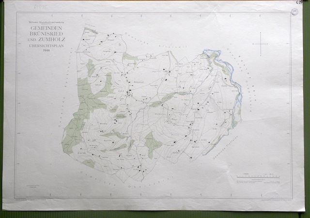
Gemeinde Brünisried und Zumholz. Übersichtsplan. Topographische Karte. von Arnold Gapany. 5:000 Format 70x100cm.
Bern, Photomec. E. Colloud 1944, Tirage limité, destiné à l’admistration fédérale, cantonale et aux communes, n’a pas été mis dans le commerce.
Bookseller reference : 32369
|
|
|
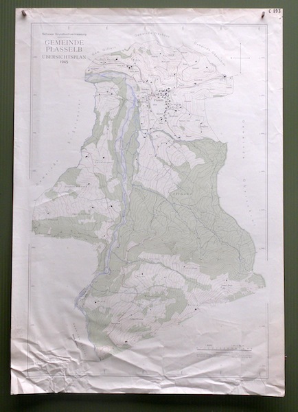
Gemeinde Plasselb. Übersichtsplan. Topographische Karte von L. Genoud. 5:000 Format 100x70cm.
Bern, Photomec. E. Colloud 1945, Tirage limité, destiné à l’admistration fédérale, cantonale et aux communes, n’a pas été mis dans le commerce.
Bookseller reference : 32358
|
|
|
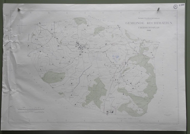
Gemeinde Rechthalten. Übersichtsplan. Topographische Karte von Arnold Gapany. 5:000 Format 100x70cm.
Bern, Photomec. E. Colloud 1944, Tirage limité, destiné à l’admistration fédérale, cantonale et aux communes, n’a pas été mis dans le commerce.
Bookseller reference : 32277
|
|
|
Gemeinde Ueberstorf. Übersichtsplan. Topographische Karte von M. Winkler. 5:000 Format 120x100cm.
Bern, 1927, Tirage limité, destiné à l’admistration fédérale, cantonale et aux communes, n’a pas été mis dans le commerce.
Bookseller reference : 32320

|
|
|
Gemeinde Alterswil. 2. Übersichtsplan. Topographische Karte von F. X. Müller. 5:000 Format 70x100cm.
Bern, sans date, vers 1925, Tirage limité, destiné à l’admistration fédérale, cantonale et aux communes, n’a pas été mis dans le commerce.
Bookseller reference : 32221
|
|
|
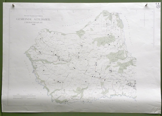
Gemeinde Alterswil. Übersichtsplan. Topographische Karte. 5:000 Format 100x70cm.
Bern, 1940, Tirage limité, destiné à l’admistration fédérale, cantonale et aux communes, n’a pas été mis dans le commerce.
Bookseller reference : 32363
|
|
|
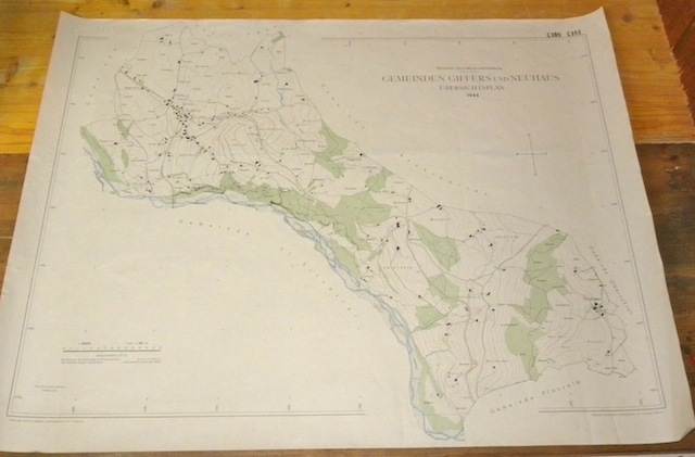
Gemeinde Giffers und Neuhaus. Übersichtsplan. Topographische Karte von Arnold Gapany. 5:000 Format 100x76cm.
Bern, Photomec. E. Colloud 1944, Tirage limité, destiné à l’admistration fédérale, cantonale et aux communes, n’a pas été mis dans le commerce.
Bookseller reference : 32233
|
|
|
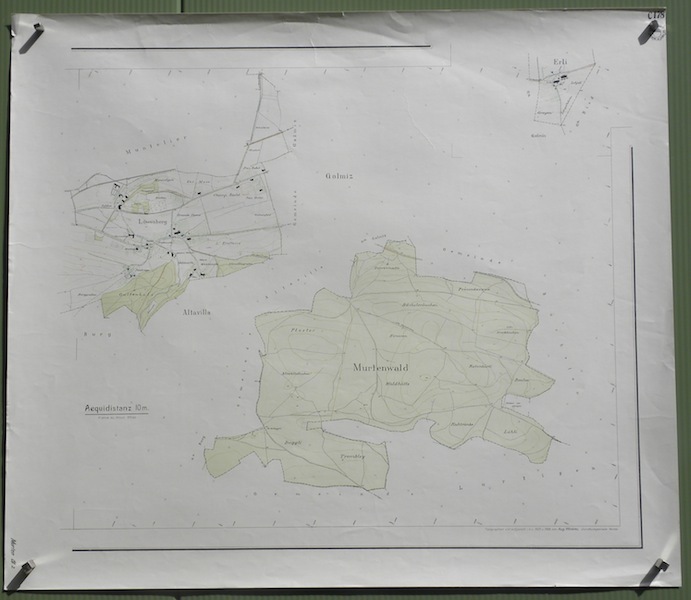
Gemeinde Murten Blatt 2: Murtenwald. Übersichtsplan. Topographische Karte 5:000 vonA. winkler. Format 92x80cm.
Bern, 1926, Tirage limité, destiné à l’admistration fédérale, cantonale et aux communes, n’a pas été mis dans le commerce.
Bookseller reference : 32123
|
|
|
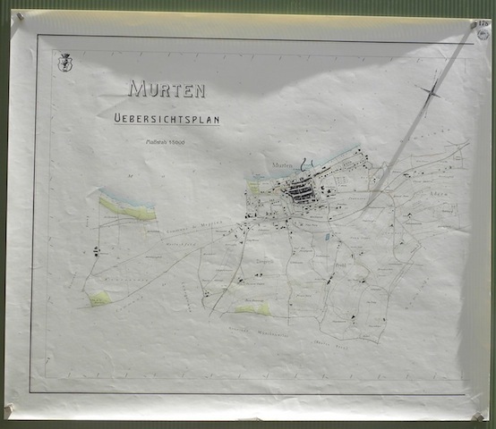
Gemeinde Murten Uebersichtsplan. Topographische Karte 5:000.
Bern, sans date, vers 1920, Tirage limité, destiné à l’admistration fédérale, cantonale et aux communes, n’a pas été mis dans le commerce.
Bookseller reference : 32003
|
|
|
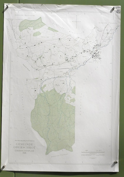
Gemeinde Oberschrot. Übersichtsplan. Topographische Karte 5:000 von L. Genoud. Format 70x100cm.
Berne, Photomec. E. Colloud 1945, Tirage limité, destiné à l’admistration fédérale, cantonale et aux communes, n’a pas été mis dans le commerce.
Bookseller reference : 32115
|
|
|
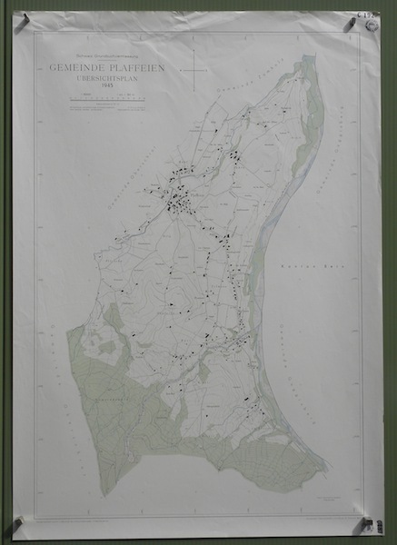
Gemeinde Plaffeien. Übersichtsplan. Topographische Karte von L. Genoud 5:000 Format 69.5x99cm.
Bern, Photomec. E. Colloud 1945, Tirage limité, destiné à l’admistration fédérale, cantonale et aux communes, n’a pas été mis dans le commerce.
Bookseller reference : 32177
|
|
|
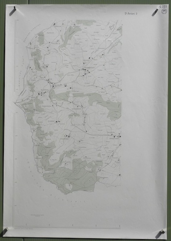
Gemeinde St. Antoni. Blatt 2. Übersichtsplan. Topographische Karte 5:000 Format 69x100cm.
Bern, sans date, vers 1945, Tirage limité, destiné à l’admistration fédérale, cantonale et aux communes, n’a pas été mis dans le commerce.
Bookseller reference : 32174
|
|
|
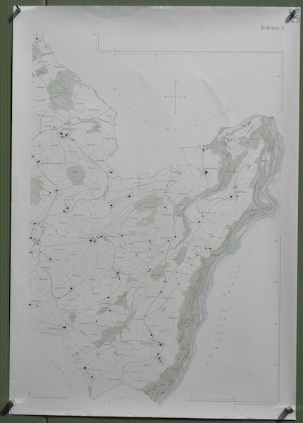
Gemeinde St. Antoni. Blatt 3. Übersichtsplan. Topographische Karte 5:000 Format 69x100cm.
Bern, Photomec. E. Colloud sans date, Tirage limité, destiné à l’admistration fédérale, cantonale et aux communes, n’a pas été mis dans le commerce.
Bookseller reference : 32176
|
|
 Receive by email
 Download as PDF document
 RSS feed


