|
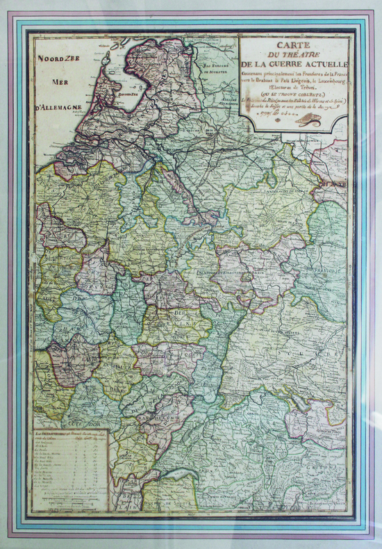
[ANONYME].
Carte du théâtre de la guerre actuelle.
1793. 65 x 46 cm ; encadrement de bois doré moderne.
书商的参考编号 : LBW-6575
|
|
|
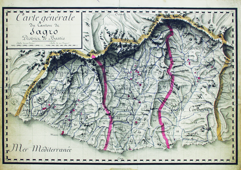
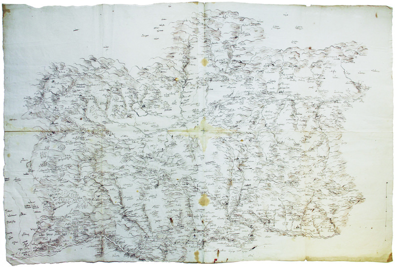
[ANONYME].
Carte générale du canton de Sagro, district de Bastia.
[début du XIXe siècle]. 46,6 x 68,4 cm, sur une feuille de 51 x 70,5 cm.
书商的参考编号 : LBW-6629
|
|
|
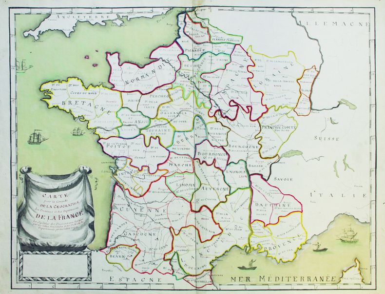
[ANONYME].
Carte pour la concorde de la géographie des provinces et des départements de la France.
[vers 1792-1793]. 48,5 x 61,5 cm, sur une feuille de 51,2 x 66,5 cm.
书商的参考编号 : LBW-6579
|
|
|
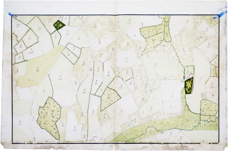
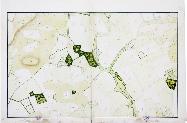
[ANONYME].
Champigni, Moulin Neuf, et terres de Gros Bois.
[fin du XVIIIe siècle]. En deux feuilles pouvant être jointes pour former une carte de 91 x 87,7 cm.
书商的参考编号 : LBW-6634
|
|
|
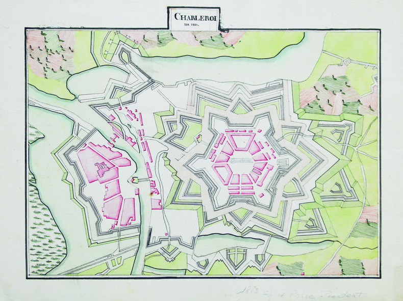
[ANONYME].
Charleroi.
An 1813. 23,5 x 30 cm, sur une feuille de 26,7 x 35 cm.
书商的参考编号 : LBW-6602
|
|
|
[ANONYME].
Dunkerque en Flandres.
[vers 1810]. 21 x 20 cm, sur une feuille de 24 x 23 cm.
书商的参考编号 : LBW-6596

|
|
|
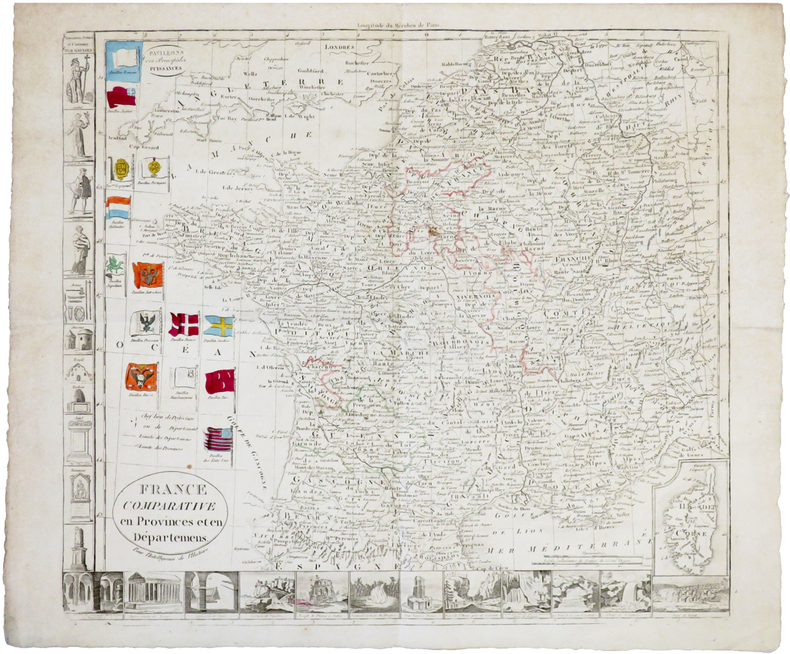
[ANONYME].
France comparative en provinces et en départemens. Pour l'intelligence de l'Histoire.
[circa 1790]. 372 x 411 mm.
书商的参考编号 : LBW-6775
|
|
|
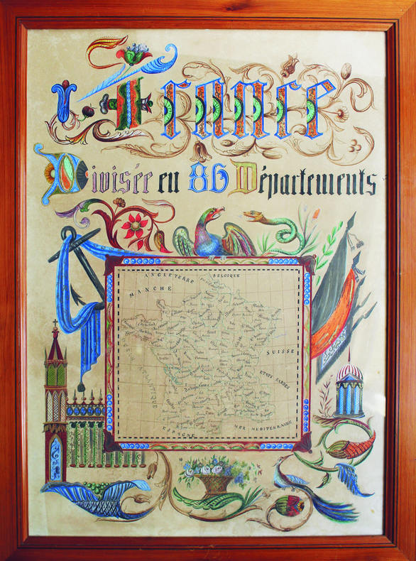
[ANONYME].
France divisée en 86 départements.
[vers 1840]. 59 x 42,5 cm environ ; encadrement sous verre en pitchpin.
书商的参考编号 : LBW-6581
|
|
|
[ANONYME].
La Conquête du Pôle.
[circa 1905]. Chromolithographie de 345 x 439 mm, montée sur toile.
书商的参考编号 : LBW-8027

|
|
|
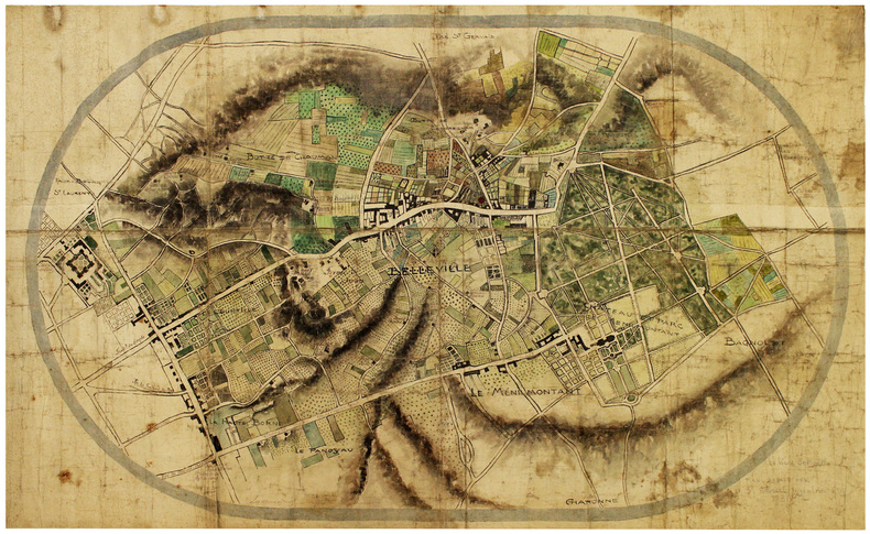
[ANONYME].
Le vieux Belleville.
[début du XXe siècle]. 76 x 125 cm, sur toile enduite.
书商的参考编号 : LBW-6598
|
|
|
[ANONYME].
Les Montaux et Doisne.
[fin du XVIIIe siècle]. 53,5 x 87 cm, sur une feuille de 62,5 x 95,5 cm.
书商的参考编号 : LBW-6568
|
|
|
[ANONYME].
Lionnois Forez.
[vers 1700]. 58 x 86 cm, sur 2 feuilles jointes.
书商的参考编号 : LBW-6582
|
|
|
[ANONYME].
Nouveau plan d'Orléans augmenté de ses faubourgs.
[vers 1810]. 20,5 x 27 cm, sur une feuille de 25 x 31 cm.
书商的参考编号 : LBW-6591

|
|
|
[ANONYME].
Nouvelle carte de la Russie d'Europe.
[1814]. 225 x 225 mm.
书商的参考编号 : LBW-2692

|
|
|
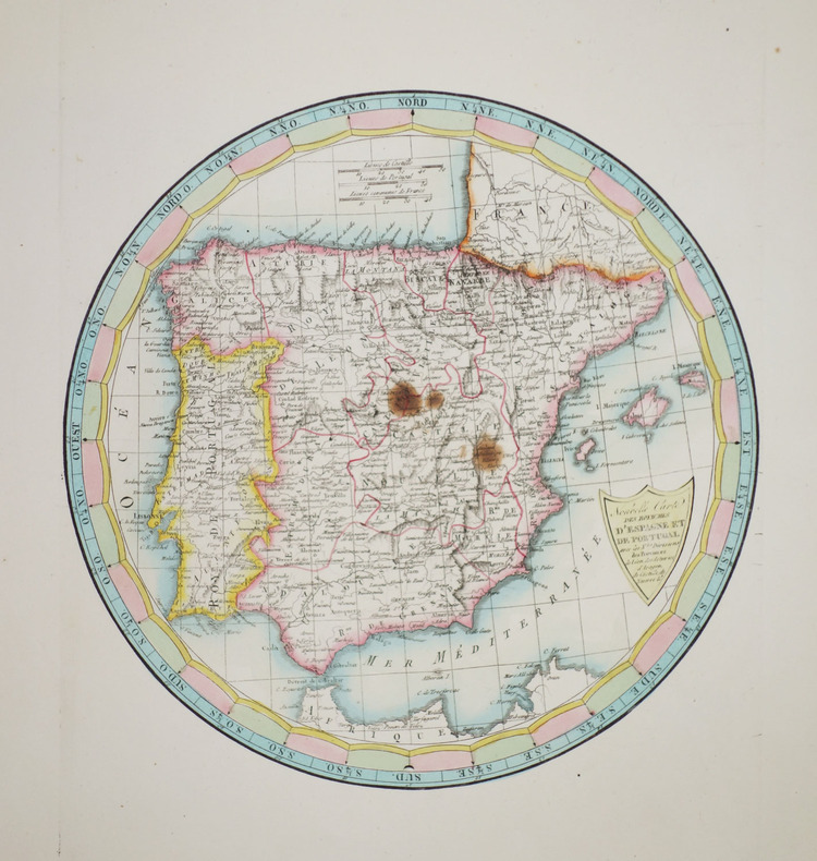
[ANONYME].
Nouvelle carte des royaumes d'Espagne et de Portugal avec les nles divisions des provinces de Léon, des Asturies, d'Aragon, de Castille, de Navarre &c.
[1814]. 239 x 239 mm.
书商的参考编号 : LBW-2697
|
|
|
[ANONYME].
Orléanais.
[milieu du XIXe siècle]. 45,3 x 60,5 cm ; monté sur carton et sous passe-partout.
书商的参考编号 : LBW-7428

|
|
|
[ANONYME].
Pareis vom Konig Navarro belegert, und entsatz durch den Princz von Parma. Anno domini 1590 19 Augusti.
1590?. 210 x 276 mm.
书商的参考编号 : LBW-6515

|
|
|
[ANONYME].
Plan d'aménagement d'un jardin en terrasse.
[fin du XIXe siècle]. 35,5 x 44 cm.
书商的参考编号 : LBW-7449

|
|
|
[ANONYME].
Plan d'une ville fortifiée dans le style de Vauban.
1764. 47 x 39 cm, encadré sous verre moderne.
书商的参考编号 : LBW-6577

|
|
|
[ANONYME].
Plan de Béthune.
[milieu du XVIIIe siècle]. 51 x 76,5 cm, sur une feuille de 53,5 x 79 cm.
书商的参考编号 : LBW-6595

|
|
|
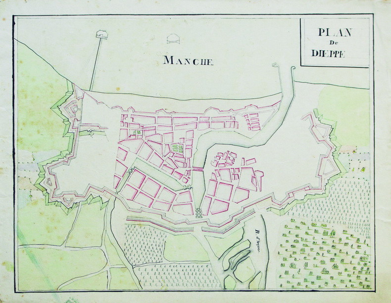
[ANONYME].
Plan de Dieppe.
[vers 1810]. 26,5 x 33,5 cm, sur une feuille de 30,5 x 37,8 cm.
书商的参考编号 : LBW-6599
|
|
|
[ANONYME].
Plan de la ferme de la Soupelière appartenant à M. le baron M.J.A. Pron.
[vers 1865]. En 18 sections montées sur toile et pliées, de 58 x 91 cm.
书商的参考编号 : LBW-6631

|
|
|
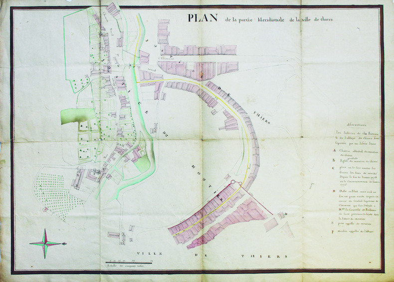
[ANONYME].
Plan de la partie méridionale de la ville de Thiers.
[vers 1780]. 53 x 70,5 cm.
书商的参考编号 : LBW-6561
|
|
|
[ANONYME].
Plan de la ville [d'Aigues-Mortes].
[vers 1880]. 39 x 56 cm.
书商的参考编号 : LBW-6566
|
|
|
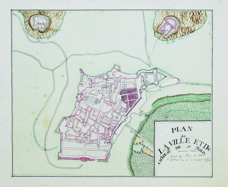
[ANONYME].
Plan de la ville et du château de St Malo.
1812. 24,5 x 29,5 cm, sur une feuille de 29,5 x 34,5 cm.
书商的参考编号 : LBW-6589
|
|
|
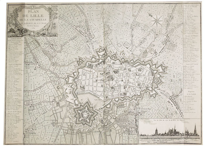
[ANONYME].
Plan de Lille de la citadelle et banlieue de la ville et de ses environs.
1784. 550 x 765 mm.
书商的参考编号 : LBW-766
|
|
|
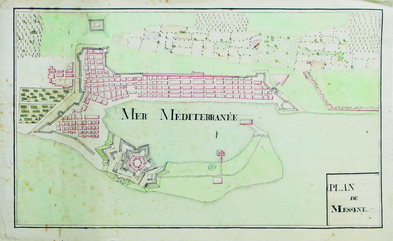
[ANONYME].
Plan de Messine.
[vers 1810]. 25 x 42 cm, sur une feuille de 27,4 x 45,7 cm.
书商的参考编号 : LBW-6604
|
|
|
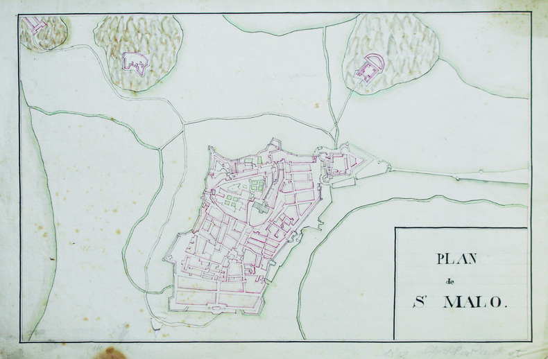
[ANONYME].
Plan de St Malo.
1813. 27 x 41 cm, sur une feuille de 30,5 x 46 cm.
书商的参考编号 : LBW-6590
|
|
|
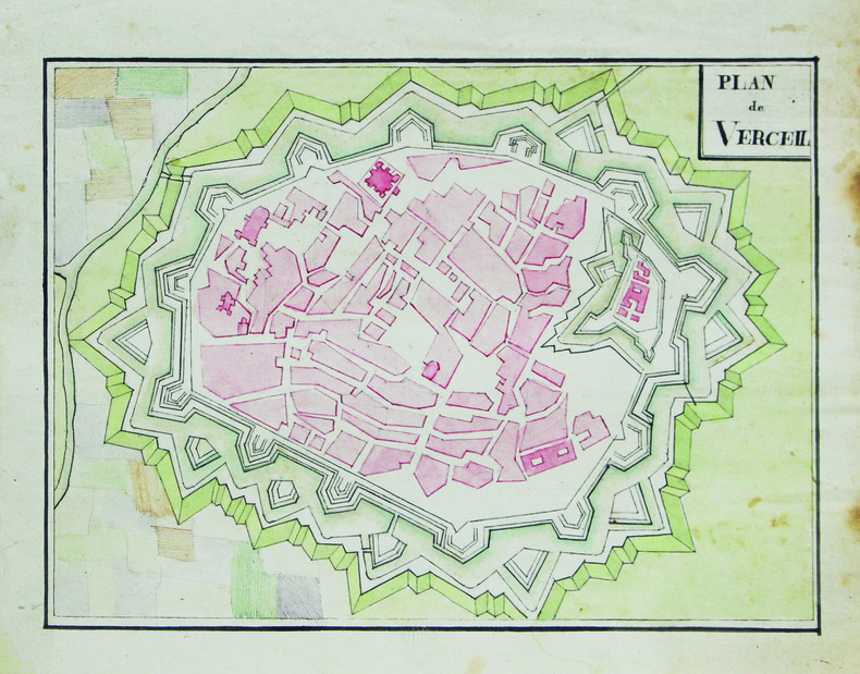
[ANONYME].
Plan de Verceil.
[vers 1810]. 16,5 x 22,5 cm, sur une feuille de 21,5 x 25,6 cm.
书商的参考编号 : LBW-6605
|
|
|
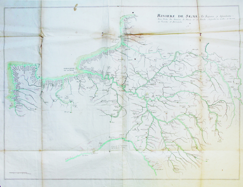
[ANONYME].
Rivière de Seine, et rivières y descendantes, avec partie des rivières de Meuse et de Moselle, ensemble les costes et rivières de Picardie et Normandie.
[fin du XVIIIe siècle]. 70 x 93 cm, sur six feuilles jointes de 80 x 97 cm.
书商的参考编号 : LBW-6597
|
|
|
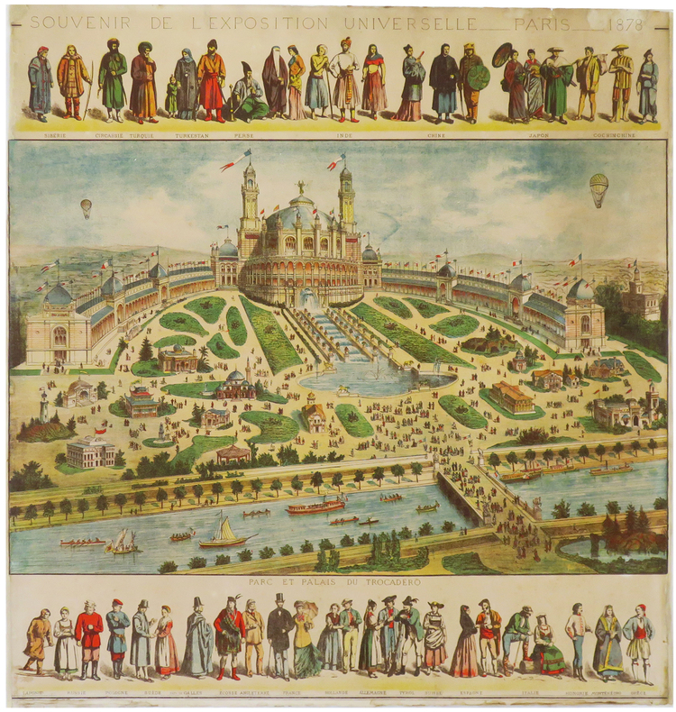
[ANONYME].
Souvenir de l'Exposition Universelle. Paris. 1878.
1878. 593 x 573 mm.
书商的参考编号 : LBW-6860
|
|
|
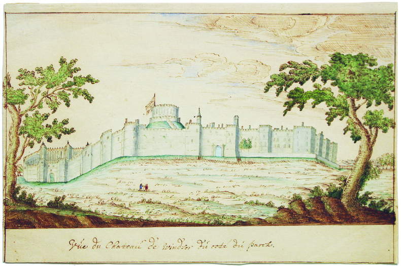
[ANONYME].
Vue du château de Windsor du côté du parck.
[XVIIIe siècle]. 14,5 x 22,5 cm, sur une feuille pliée en deux de 22,7 x 30,7 cm.
书商的参考编号 : LBW-6609
|
|
|
[Arabian Peninsula].
Omoumi Mamalik Mahrousi Shahani [General map of the protected countries. Ottoman Empire]. Istanbul, Matbaa-i Amire [Imperial Military Press], [1896 CE =] 1312 H.
150 x 130 cm. Scale: 1:3,000,000. Colour lithograph, dissected into 24 sections and mounted on original linen. Very rare, monumental wall map of the Ottoman Empire, featuring one of the largest and most detailed printed representations of the Arabian Peninsula produced in the Islamic World prior to World War I. Perhaps more than any other map, it reveals the immense logistic challenges faced by Hajj pilgrims just in advance of the construction of the Baghdad and Hejaz Railway systems. Printed for official use, the map appeared at a time when the Sublime Porte was going to great lengths to shore up its authority in the Red Sea region (Hejaz, Asir, and Yemen), while being pressured by Britain to retreat from the domains it claimed in the Arabian Gulf (Kuwait, Al-Qatif/Hofuf, and Qatar). - Indeed, the present map would have been of great value to Ottoman generals and cabinet officials for strategic planning, as Arabia was increasingly a focus of global attention and interference. It served as the ideal strategic aid to chart the future construction of the Hejaz Railway (built 1900-08) and the Baghdad Railway (extended from the Anatolian Railway, from 1903 onwards) and delineates some of the world's most strategically important railway lines before 1900. - The main map encompasses most of the Arabian Peninsula, from Qatar and the Hadramaut westwards (while far eastern Arabia, including Oman and what is today the United Arab Emirates is featured in an inset, lower left). The coastlines and rivers are crisply depicted; mountain ranges are expressed by delicate tan shading; all cities and towns of note are labelled; the names of regions and tribal areas are revealed, while all key roads and Hajj caravan routes are delineated. The map features stellar coverage of the western Gulf region, labelling Qatar (then an autonomous part of the Ottoman Empire), Bahrain (a British protectorate prized for its fine natural harbour), and Kuwait, an autonomous Sheikhdom within the Ottoman Empire that would shortly become a British protectorate. Inland, the map details the Saudi-Wahhabi domain Nejd, with its capital Riyadh, while to the northwest lies the territory of the rival Al-Rashid clan, with its capital Ha’il. - Minor soiling and waterstaining, occasional light edge wear. Tears in linen partly repaired. A rare survival. Osmanli cografya literatürü tarihi [History of geographical literature during the Ottoman period], pp. 756f. David Rumsey Map Collection 13186.000 (the single other copy known in the trade). Not in Al-Qasimi collection (1493-1931).
|
|
|
[Aramco - Map of Saudi Arabia and the Gulf].
Central Area. Scale 1:1,000,000. [Dhahran, Aramco / USGS, 1953 or shortly after].
763 x 763 mm. Scale 1:1,000,000. Key in English. Printed on cloth. Blueprint map of the Gulf, showing Qatar, Bahrain, and Kuwait, as well as parts of Saudi Arabia, Iran and Iraq. It pays particular attention to oil fields, naming them individually and illustrating oil pipelines and facilities, including the 435 kilometre Qatif-Qaisumah pipeline which connects to the Trans-Arabian pipeline, as well as the offshore terminal and refinery at Ras Tanura. The map records some of the problematic borders within the region, showing the Iraq-Saudi Neutral Zone, the Kuwaiti-Saudi Neutral Zone and Buraimi Oasis. Among the more notable oil fields are Greater Burgan, the world's largest sandstone oil field, consisting of the Burgan field itself along with the much smaller Magwa and Ahmadi fields, as well as the Wafra field discovered in 1953 by the American Independent Oil Company and Pacific Western Oil Company. Wafra was unique in being operated jointly under separate concessions from two countries, Kuwait and Saudi Arabia, granted to American Independent Oil Company and Getty Oil Company (formerly Pacific Western Oil Company) respectively. - Slightly toned along folding lines and lower left margin.
|
|
|
[Armenia].
Arménie Russe. Rossijskaja Armenija. Venice, [Imprimerie des Méchitaristes de] St. Lazare, 1828.
260 x 380 mm. Engraved map mounted on cloth. Matted. Early map of Russian Armenia, featuring the eight provinces annexed by Russia in 1828, with key in French and Russian. Following Qajar Iran's defeat in the Russo-Persian War (1826-28) and the 1828 Treaty of Turkmenchay, Eastern Armenia was, among other territories, ceded to Russia. It would remain part of the Russian Empire until its collapse in 1917. - Printed at the Mechitarists' press on the island of San Lazzaro, Venice, where the Armenian order had set up their colony in 1717. They began their editorial activities as early as the following year and set up a printing press, famed for its typographic capability in many languages and alphabets, in 1789. - Very rare; catalogues list a single specimen in the British Library. OCLC 556404373.
|
|
|
[Asia] - Gaebler, Eduard.
Asien. Leipzig, [1892].
254 x 201 mm. Lithographed map. Scale 1:50,000,000. Gilt wooden frame (290 x 357 mm). Political map of Asia prior to WWI, showing the Arabian Peninsula and the Gulf, the Ottoman Empire, Russia, China, India, Japan, and South East Asia, including the Philppines and Indonesia, as well as large parts of Europe and the westernmost part of Africa. With an inset map of Tokyo and its surroundings (1:500,000). - Early edition of Eduard Gaebler's map of Asia, published in "Neuester Hand-Atlas über alle Teile der Erde" (Leipzig, Gaebler's Geographisches Institut, 1892). The map saw numerous reissues; a slightly revised edition appeared in Gaebler's "Kleiner Handatlas" as late as 1933. - Slightly foxed. Frame with some traces of worming. An appealing map in an attractive wooden frame with a gilt border.
|
|
|
[AVIATION].-
Aeroplanes in six different positions.-
Oilettes after the Original Drawings by G.T. CLARKSON. Raphael Tuck & Sons. London. Paris & New York. s.d. (vers 1914). 6 belles cartes postales couleurs représentant chacune une position d'aéroplane en plein vol dans leur rare pochette d'origine (un peu passée). Cartes à l'état neuf.|Les mêmes sans la pochette: 250FF.
书商的参考编号 : ORD-638
|
|
|
[BAGDAD ARCHAEOLOGICAL CITY GUIDE and HUGE CITY MAP].
Baghdad [Archeological city guide with huge city map]. Foreword by Isa Salman (Director General of Antiquities).
Fine English Paperback. Roy. 8vo. (23 x 14 cm). In English. 29 p., color ills., a huge map (not opened). Baghdad [Archeological city guide with huge city map]. Foreword by Isa Salman (Director General of Antiquities). Very detailed modern guide including architectural works in Baghdad: Historical shrines, mausoleums and mosques, churches, monuments, etc.
|
|
|
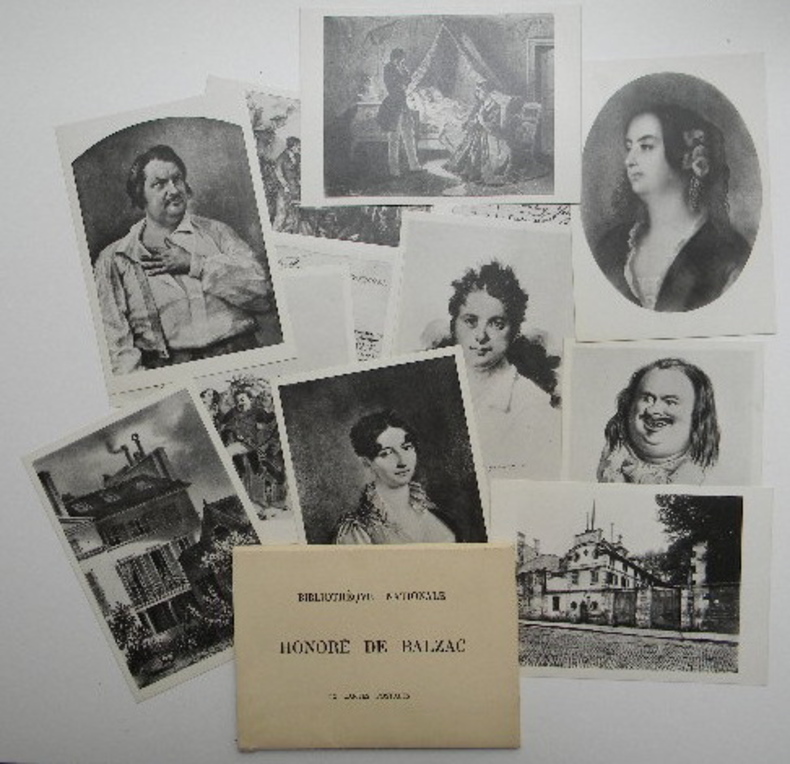
[BALZAC (Honoré de)]
HONORE DE BALZAC. 12 cartes postales.
Suite de 12 cartes postales sous chemise imprimée, sd (sans doute publiées à l'occasion du centenaire en 1950). Editions Calavas, Paris. Belle iconographie balzacienne. Rare suite complète.
书商的参考编号 : 6930
|
|
|
[BEARN].-
Carte du Ministère de l'Intérieur au 1/100.000e, feuille, XI-35 : PAU.
P., Hachette, 1924, feuille repliée sous une couverture cartonnée in 12 ; carte en couleurs.
书商的参考编号 : 63405
|
|
|
[Beauce ; Cartes à jouer ; Pays chartrain] GARNIER, Jacques-Marin
Histoire de l'imagerie populaire et des cartes à jouer à Chartres : suivie de recherches sur le commerce du colportage des complaintes, canards et chansons des rues / par J.-M. Garnier
Chartres, Imprimerie de Garnier 1869 In-8 20 x 13 cm. Broché, couverture grise, titre en noir sur le dos et le premier plat, VIII-450 pp., notes en bas de page, bandeau, lettrines, culs-de-lampe,50 gravures hors-texte, table des matières, catalogue éditeur in fine, 16 pp. Couverture poussiéreuse, intérieur frais.
书商的参考编号 : 105243
|
|
|
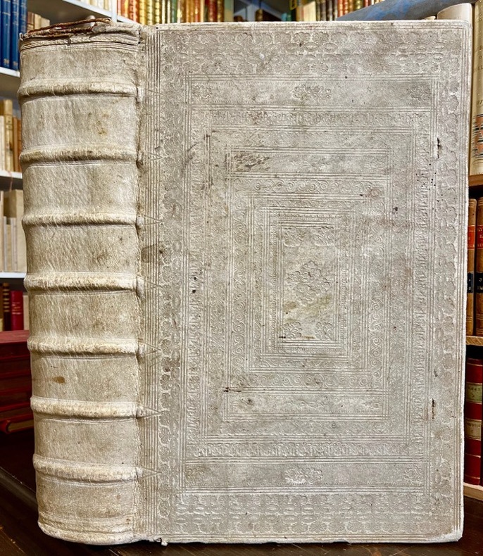
[BIBLE DE GENEVE]; DESMARETS Samuel:
La sainte Bible, qui contient le Vieux et le Nouveau Testament : édition nouvelle, faite sur la version de Genève, reveuë et corrigée, enrichie, outre les anciennes notes, de toutes celles de la Bible flamande, de la plus-part de celles de M. Diodati, et de beaucoup d'autres, de plusieurs cartes curieuses, et de tables fort amples, pour le soulagement de ceux qui lisent l'Escriture sainte. Le tout disposé en cet ordre, par les soins de Samuel des Marets […] et de Henry des Marest, son fils [...].
A Amsterdam, Chez Louys & Daniel Elsevier, 1669. 4 parties en 2 tomes reliés en un volume in-folio, plein vélin estampé à froid, sur ais de bois. Traces d'attaches. [42]-366 ; [2]-162 ; [2]-202 ; 70 feuillets imprimés sur deux colonnes. *4; a-e6 ; f8; A-Z6 ; Aa-Zz6 ; Aaa-Ppp6 [et] A-Z6 ; Aa-Cc6 ; Dd8 [et] *2 ; A-Z6 ; Aa-Kk6 ; Ll4 [et] A-L6 ; M4.
书商的参考编号 : 18982
|
|
|
[BILLANCOURT].-
Sortie des ouvriers des Usines Renault.-
Carte postale E.M. 1431. Vers 1905. Carte postale (140 x 91mm) timbrée sur le recto (timbre presque entièrement déchiré). Vue très anîmée des bâtiments avec une grande foule d'ouvriers. Bon exemplaire.
书商的参考编号 : ORD-1167
|
|
|
[BLOCQUEL (Simon)]
Les Tours de Cartes les plus amusans, rendus faciles par un grand nombre de figures gravées.
1840 cartonnage modeste. in-16, titre, p.15 à 100, 9 planches comprenant 49 figures plus une sur le titre comprises dans la pagination, gravées sur bois. P. Delarue Lille Castiaux (ca. 1840)
书商的参考编号 : 14296
|
|
|
[BOURDIN] [CARTES POSTALES ANCIENNES]
Le Riz d'Indo-Chine
Sans lieu, 1931. 1 ensemble de 6 cartes postales anciennes représentant les activités liées à la culture du riz en Indo-Chine.
书商的参考编号 : 12245
|
|
|
[BULLET (J.-B.)]
Recherches historiques sur les cartes à jouer,. Avec des Notes critiques & intéressantes, par l'Auteur des Mémoires sur la Langue Celtique.
Lyon, Deville, 1757. petit in-8, 4ff.n.ch.-163pp.-1f. Veau fauve granité, dos à nerfs orné de caissons aux filets dorés, fleurons et petits fers dorés, pièce de titre rouge, tranches rouges. (Reliure de l'époque).
书商的参考编号 : 20485
|
|
|
[CANAL DE SUEZ] Maclure & Macdonald Lithographers to the Queen London
LITHOGRAPHIE ORIGINALE : "A BIRD'S EYE VIEW OF THE SUEZ CANAL" , supplément gratuit du Journal "THE GRAFFIC" du 2 Septembre 1882, Maclure & Macdonald Lithographers to the Queen London,
London THE GRAFFIC 1882 broché une Vue lithographique en couleurs, Format : 26.7 x 10.25 inches ( 83 x 31 cm), supplément gratuit du Journal "THE GRAFFIC" du 2 Septembre 1882, Maclure & Macdonald Lithographers to the Queen London,
书商的参考编号 : 28302
|
|
|
[Carte BLONDEL]
Carte FRANCE POLITIQUE, EMPIRE FRANCAIS, ZONE d'OCCUPATION en ALLEMAGNE
Une belle carte en couleurs, format ouvert 910 x 695 mm, éditée en 1931, Blondel La Rougery Editeur, bon état
书商的参考编号 : LFA-126737235
|
|
|
[Carte d'Etat-Major]
CARTE d'ETAT-MAJOR : AUTUN
Carte géographique format ouvert 675 x 430 mm, éditée au début du XXe siècle, bon état
书商的参考编号 : LFA-126714583
|
|
|
[Carte d'Etat-Major]
CARTE d'ETAT-MAJOR : RODEZ
Carte géographique format ouvert 675 x 430 mm, éditée au début du XXe siècle, bon état
书商的参考编号 : LFA-126714593
|
|
 ?????????
 ?????PDF???
 RSS feed


