|
|
|
BRUSTOLON Giambattista (Venezia 1716 – 1796)
Vue de la Basilique Vaticane & du Chateau S. Ange, jadis Mausolée d’Adrien
Acquaforte e bulino, firmata in lastra in basso a destra. Da un disegno del Canaletto, oggi conservato al British Museum [1858,0626.221].Magnifica prova, impressa su carta vergata coeva, con ampli margini, in perfetto stato di conservazione. Il Museo Correr possiede una raccolta di quindici fogli raffiguranti vedute di Roma incise da Brustolon su disegno del Canaletto; il frontespizio, manoscritto, reca l’iscrizione Vari Prospetti di Roma Antica e Moderna. Il catalogo della tipografia Remondini del 1817 elenca sempre 15 soggetti “romani”. Tuttavia secondo il Moschini le vedute di Roma del Brustolon sarebbero addirittura venticinque. Il nostro esemplare differisce nel titolo - in francese - rispetto a quello pubblicato nel catalogo della mostra "Roma Veduta" (Roma, 2000).Rarissima. View of the Tiber and Rome from the Basilica of St Valentino on the Via FlaminiaEtching and engraving, signed on lower right plate. After a drawing of Canaletto, today at the British Museum [1858,0626.221].Magnificent work, printed on contemporary laid paper with wide margins, in perfect condition. The Correr Museum owns a collection of fifteen sheets depicting views of Rome engraved by Brustolon after drawings of Canaletto; the front page, handwritten, bears the inscription Vari Prospetti di Roma Antica e Moderna. The 1817 catalogue of the typography of Remondini lists 15 “Roman” subjects; nonetheless, according to Meschini, Brustolon’s views of Rome are not less than twenty five. Very rare. Succi, Da Carlevarijs ai Tiepolo, p. 82; Maria Catelli Isola, in "I ponti di Roma" (1975): p. 76, n. 120; Roma Veduta (2000): pp. 181-182, n. 37 (variante).

|
|
|
Bryant, Arthur; et al
The Illustrated London News (ILN), December (Dec.) 2, 1944 - The Fall of Geilenkirchen / Liberation of Metz
Pages 617-644. Features: Cover photos of the Mosquito Mark XVIII and its U-Boat strafing gun and six-pounder cannon; One-page Karsh photo-portrait of Sam Rayburn; Twelve excellent photos from Geilenkirchen, recently captured by British and French forces; Four photos at the Koenigsmacher Fort, which apparently made marine fittings; The Liberatioin of Metz - six photos in the city; Photos in the recently liberated cities of Belfort and Strasbourg; Photos of the advance on Venlo; Variety of photos of mine-clearing, destroyed German rolling stock, and humorous signs; Article entitled "Allied Advance to the Rhine" with maps; Photos of Field-Marshal Sir Harold Alexander, General Sir Henry Maitland-Wilson, and Lieut.-General Mark Clark; Two pages of illustrations of the launching of V-2 rocket bombs with explanation; Six photos of V-2 rocket parts found wrecked in Belgium; One page of illustrations explaining a simple system for castaways to make sea water drinkable; Photo of the U.S.S. "Missouri"; Interesting photos shows long contrail of V-2 rocket, four short contrails of fighters and flying fortress in foreground; Two photos of the burning U.S. light aircraft carrier "Princeton" which sunk in the battle of the Philippines; Aerial photos of the obliterated towns of Duren and Julich; Before and after aerial photos of V-2 factory at Weimar which was hammered by U.S. heavy bombers; Photos of personalities of the week include General Philippe Leclerc, Sir George Clausen, Daniel Sultan, Naik Yeshwant Chadge, V.C., John D. Baskeyfield, V.C., Col. C. Meyer, Maj.-Gen. Dunckern, Duncan Sandys, M. Mikolajczyk, David Vivian Currie, V.C., Sir Edward Grigg, M. Joseph Caillaux, C.W. Alfrey, Sir A.S. Eddington, Count Carandini, and Tulbahadur Pun, V.C.; Photos of damage to Florence - medieval sites destroyed by hun vandalism; and more. Unmarked with average wear. Coverfold taped. A sound vintage copy. Book

|
|
|
Bryant, Arthur; et al
The Illustrated London News (ILN), November (Nov.) 25, 1944 - Tirpitz is Sunk / With Patton's Third Army Near Metz / Recapture of Leyte
Pages 589-616. Features: Cover illustration of the capsized "Tirptz" in Tromso Fjord; One-page Karsh photo-portrait of Elmer H. Davis, U.S. Director of the Office of War Information; Two-page illustration of Captain David Jamieson winning a V.C. as he directs an action to save a bridgehead; Photo of Himmler reading Hitler's proclamation at delayed celebration of the Munich beer cellar putsch; Photo of Hitler awarding Belgian Rexist leader, Leon Degrelle; Photos of British Second Army tanks in action on the Western Front; Photo-illustrated article entitled "The Allied Offensive in the West; Five photos in the wrecked German town of Gressenich, captured by the U.S. First Army; Two pages of maps showing the Western Front; Six photos of the U.S. Sixth Army in action in Germany; Photos of personalities of the week include Sir Charles Craven, Rhoderick McGrigor, Sir Robert Kelly, General Koenig, Major-General Bedell Smith, Churchill visiting French troops at Besancon, Air Chief-Marshal Sir Trafford Leigh-Mallory and his wife, Marjorie Maxse, A.C. Maclaren, Dr. H. Colijn, A.G. Williams and J.B. Tait (the men who led the attack on the "Tirpitz"; Centrefold compilation of seven photos with General Patton's Third Army in and around Metz; Two pages of fascinating illustrations explain the "Hollow Charge" - the deadly explosive principle which uses blast to bore a hole through solid armour; Photo of American jet-propelled P-59A Airacomet; Photo of U-boat"U-570" renamed H.M. Submarine "Graph" on surface; Photos of "Buffalo" amphibious tank; Nostalgic ads; Two pages of photos of the U.S. Liberation of Leyte; and more. Unmarked with average wear. Coverfold taped. A sound vintage copy. Book

|
|
|
Bryant, Arthur; Falls, Cyril; et al
The Illustrated London News, March (Mar.) 21, 1964 - Funeral of King Paul of Greece / 60 Years of the Anglo-French Accord
Pages 413-468 plus 4 pages of ads. Features: Cover Photo portrait Of The new King of the Hellenes, Constantine II, with Queen Frederika, at the funeral of his father; Photo of Princess Margaret with Kenneth Corney; Page of photos of celebrations upon the birth of Prince Edward; Two pages of dramatic photos and text from Cyprus - fighting in Ktima, threats of Turkish invasion, and first arrivals of the UN peace force; Photo-illustrated article on Paul, King of the Hellenes; Photo of riots in Phnom Penh; Photo of Geneva motor show; Photo of unveiling of statue of Pope Pius XII; Photo of 84-year-old Gen. Douglas MacArthur after surgery, escorted by Army Surgeon General Lieut. Gen. Leonard Heaton; Photo of the new president of Venezuela, Dr. Raul Leoni, receiving the sash of office from his predecessor, Pres. Betancourt; Page of photos of flooding in five states touching on the Ohio River basin include scenes near Williamsport, PA, the town of Sugar Grove, OH, Albany, IN, Shepherdsville, KY, an Ohio amusement Park, and Marietta; Photo of the first submarine ever built, the Fenian Ram, on display in Paterson New Jersey; Photo of Pope Paul receiving group of nuns recently expelled from the Sudan; Photo of jubilant George Lodge in Concord, New Hampshire where he defeated Sen. Goldwater and Gov. Rockefeller in the presidential primary; Photo of Independence Day children's party in Accra, Ghana, held by Mrs. Fathia Nkrumah, wife of the president of Ghana (also shown); Photo of the Royal Shakespeare Company applauding Yugoslavian president Tito at Belgrade; Book review of "King Edward VII" by Philip Magnus; Major coverage of Sardis excavations - part two; A survey of the 60 years of Anglo-French accord; One-page compilation of maps, text and photos describe's areas affected by the Anglo-French agreement, and the signatories to the document of April 8, 1904; Centrefold (free from staples) colour photos show the changing landscape of France; Entente Cordiale - page of historic photos illustrates France and Great Britain in peace and war; Entente Cordiale - page of photos of Anglo-French friendship since 1940; Page of photos illustrates how the English Channel is crossed by aircraft, ship, and train ferry, with artist's impression of future hovercraft car and passenger ferry; Impressive page of five aerial photos of huge French automotive manufacturing works - Renault, Simca, Peugeot, and Citroen; Two pages of photos illustrate developments in the aircraft and shipping industries of France today; One-page illustration of novelist, poet, broadcaster and one of the most vivid personalities living, Sir Compton McKenzie; Two pages of photos of the funeral of King Paul in Athens; Drawings of colonial America by John White; Photos of personalities of the week include Sir Newman Flower, Sir Knox Helm, Mr. R. G. Routh, Sir Robert Clark-Hall, Gen. von Lettow-Vorbeck, Sir R. Robinson, J. Brian Neill, C. Robin Mayer, Col. Joan E. Henderson, Lord Newton C. Ron Jacobs, J. Michael Cowman, Gen. A. Jolly, Jack Ruby (sentended for death), Capt. David I. Holland, Lieut. Harold W. Welch, Capt. Melvin J. Kessler, and James (Jimmy) Hoffa (convicted of bribery); Photo of the teapot collection of Rev. C. J. Sharp; Photo of ticket barrier smashed by derailed car at Hammersmith underground station; Photo of funeral for 16-year-old cat named Peter, Whitehall's chief mice catcher; Photo of Cambridge University women's rowing crew after their victory over Oxford on March 14; One-page photo of polar bear cubs seeing the world for the first time at Whipsnade Zoo; Photo of Angus Ogilvy greeting the England women's hockey team before a match versus Scotland at Wembley; Photo of automatic ticket reading barrier introduced by London transport at Chiswick Park station; and more. Unmarked with average wear. A sound vintage copy. Magazine

|
|
|
Bryant, Arthur; Falls, Cyril; Pycraft, W.P.; Byles, Charles
The Illustrated London News (ILN), Saturday, June 22, 1940 - Cover Photo of Long Line of Bren Carriers
Pages 829-860. Features: Photo of Ernest Bevin appealing to radio listeners to financially support the war effort; Nice one page photo-portrait of the President of Turkey, General Ismet Inonu, with Dr. Refik Saydem and Kemal Gadeletch; Seven photos of the Britsh forces in Egypt opposing the Italians; Five photos of India's troops and equipment in Egypt; Two-page illustration of dozens of German planes airborne beneath the caption "The Enormous Number of Planes Needed to Land Even a Thousand Men in Britain By Air"; Photo-illustrated article on trees and their strange roots; Four action photos of R.A.F. bombing of German convoys in the Dunkirk area; The War with Nazi Germany - The French Tragedy (article with two maps showing stricken France and the widened sphere of the war since it was joined by Italy; Two-photos of French refugee carts and horses destroyed by the Nazis; Eight photos of American Lockheed "Hudson" planes of the R.A.F. over Heligoland; Four magnificent aeroal photos of Paris, spared by its capitulation; Chronology - from Sedan to the Debacle; Two sketches of Paris, now in the shadow of the swastika; Photos of thirteen personalities of the week include Lord Cromwell (reported missing), Italian Ambassador, Signor Bastianini, and family departing London, Mr. E. Stanley Hall, Viscount Fincastle (KIA), and Lieut.-Gen. Sir Clive Liddell; Six photos include the heroic Calais Garrison, British cruiser 'Calypso' which was lost, Polish submarine "Orzel", and more; Photo of Lockheed bomber being horse-drawn into Canada to conform with neutrality regulations; Photo of the King decorating Lieut.-Col. A. Cazenove, Coldstream Guards; photo of L.D.V. (Local Defence Volunteers) march in London; Several illustrations of the principal weapon inair-fighting - aircraft machine guns; Nice two-page spread of 11 photos illustrated the great drive to give teh empire swarms of iron cavalry - armoured fighting vehicles built at speed in Britain and Australia; Nice colour back cover ad for North British Golf Balls shows British fighters in flight; Many more nice vintage ads. Average wear. Minor nibble from top of coverfold. A quality copy of this dramatic wartime issue. Book

|
|
|
Bryant, Arthur; Falls, Cyril; Squire, Sir John;
The Illustrated London News (ILN), Saturday, April (Apr.) 4, 1942 - Cover Photo of Gaping Hole in U.S. Freighter, the "Absaroka"
Pages 397-424. Features: (Now) extremely politically incorrect "loose lips sink ships" poster with illustration of African with massively protruding lips is held by young lady as she stands in a gaping hole blasted in the side of U.S. freighter "Absaroka"; Photo of Rear-Admiral P.L. Vian; Photo of Italian battleship "Littorio"; Illustrations of brillian Mediterranean action - the Malta convoy gets through; Photos and maps of the daring attack on St. Nazaire's big dry dock; Four great aerial photos of R.A.F. daylight raids on Le Trait and Le Havre; Photos of numerous people in the news, including General Chiang Kai-Shek and his wife, Captain Guy Dollman, plus the H.M.S. "Trident" which torpedoed the "Prinz Eugen"; Three pages of illustrations of underground war factories where workers labour and live; Armoured Warfare Today - article with photo of British Mark IV.A cruiser tank and the tank transporter truck it can drive onto; One page of photos of specialied aircraft for warfare; Photo of Lord and Lady Elton and son Rodney with dogs at their home; Air photos of R.A.F. bomb damage evidence in Cologne; Elaborate centerfold illustration of a Japanese landing force, supported by warships and airplanes - typical of many since war opened in the Far East; H.M. Submarine "Talisman" flys her own Jolly Roger, as does submarine "Utmost"; Photos of mascots "Butch, M.C." and "Bacchus"; Photo of Russia's Maisky presenting 'Order of Lenin' to R.A.F. fighter pilots, including Wing Commander Ramsbottom Isherwood; Photos of human guinea pigs being used to find an antidote for mustard gas; One-page admiralty chart of Australia's Outer Bastion - Port Moresby and Environs; Photos of clothing and furniture provided to those who've been bombed out; Photos of British Soldiers "Toughening Up" at an "Assault School"; Two pages of great illustrations explaining the deadliest weapon in naval warfare, the torpedo, and its intricate mechanism and modus operandi of firing; Photos of Pigmy Aborigines of the Andaman Isles; Four nice photos of the Andaman Islands which have now been seized by Japan; Five photos of Malta, the most-bombed isle in the British Empire; vintage ads. This issue was never stapled. Contents clean and unmarked with moderate wear. A worthy copy of this great wartime issue. Book

|
|
|
Bryant, Arthur; Falls, Cyril; Squire, Sir John;
The Illustrated London News (ILN), Saturday, June 6, 1942 - The Making of a Halifax Bomber
Pages 645-662 and 667-672, lacking pages 663-666. Features: Cover illustrations of how enemy movements are watched in the desert; One page of illustrations explain anti-tank mines - "A Deadly Defensive Weapon in Mechanised Warfare"; Two-page illustration of 1,000 bombers, "A Panorama showing the bomber force which has smashed Rhineland and Western Germany"; Air photo of destroyed Gennevilliers Power Station in Paris; Photo of bomb damage in Canterbury; Air photo of bomb damage to B.F. Goodrich rubber tyre works in Paris; Three pages of very informative photos of key stages of production of the "Halifax" bomber; The Campaign in Russia and Libya - article with maps of Shanghai district, Kharkov area, and Tobruk area; Large photo-portrait of Air Marshal A.T. (Bomber) Harris, Commander-In-Chief, Bomber Command; The Aftermath of Battle - Scenes of Desolation in the Desert When the Fighting Has Ended - Four interesting photos over two pages; Centrefold illustration of the Eighth Army Salvaging an immobilised tank with a tank transporter; Six photos of salvaging tanks and enemy guns behind the front in Libya; Four photos of U.S. fighter-bombers - Curtiss "Kittyhawks" in the desert battle; Photos of ten personalities of the week include Mr. Arthur Merton, Mr. George W. Kettle, actor John Barrymore, Mexican President Avila Camacho, and Sir Archibald Sinclair; Two photos of scorched earth at Burma's Yenangyaung's oil fields; Photo of General MacArthur in Australian Parliament; Photo of midget Japanese submarine captured at Pearl Harbour; Nice colour back cover B.S.A. ad features illustration of tanks on parade with Big Ben in background. This copy was never stapled. Clean and unmarked with moderate wear. Aside from the four missing pages, a quality copy. Book

|
|
|
Bryant, Arthur; Falls, Cyril; Squire, Sir John;
The Illustrated London News (ILN), Saturday, May 23, 1942 - Cover Photo-Portrait of Marshal Semen Timoshenko, Russian Commissar of Defense
Pages 593-620. Features: Photo of Marshal Timoshenko's splendid reserves; One-page air-photo indicating bomb damage in Rostock after four-day "Blitz"; Two-pages of illustrations beneath caption "Madagascar daringly planned operations lead to the surrender of Port Diego Suarez in 48 hours; Photo of crew of the submarine "Thunderbolt" (formerly "Thetis") safely home after a year; Photo of French Aircraft-carrier "Bearn" in Martinique; Six photos from Martinique illustrated its plight of barnacled warships and derelict aircraft; Two pages with fourteen photos present "Facets of the War on the Russian Front where Spring Has Heralded New Offensives; The Russian Front Awakens - article with maps of Kharkov and the Kerch Peninsula; The Crete Battle Goes on - five photos; Two pages with twelve photos illustrating Free French Forces Fighting in the Desert Battle Zone; Centrefold illustration shows steel foundry which produced munitions in Napoleon's wars, now making steel for use against Hitler; One-page illustration of molten steel for armour-plating 'tapped' from a giant container; Photos of personalities of the week include Lieut.-Com. Hussey, Mr. Churchill before large crowd at Leeds, and racehorses Big Game and Sun Chariot; One-page illustration of lop-sided flying freak, the Luftwaffe's Blohm and Voss "141" reconnaissance monoplane; Two pages of clear photos showing British Soldiers training on obstacle course; Five photos of life in France under the Nazi heel; Five Barrage Balloon illustrations by Balloon Command artists; nice half-page ad for Tube Investments, Ltd.; Isabel Burton - A Remarkable Woman; Back cover colour ad for Johnnie Walker shows harbour view through window; more vintage ads. Minor nibble from foot of spine. This copy was never stapled. Clean and unmarked with moderate wear. A quality copy of this vintage issue. Book

|
|
|
Bryant, Arthur; Falls, Cyril; Squire, Sir John;
The Illustrated London News (ILN), Saturday, May 30, 1942 - Tokyo, The Most Inflammable Capital in the World
Pages 625-644. Features: Cover Photo Portrait of 60-ton M-1 Tank Crushing Heavy Truck; Photo of FDR presenting Congressional Medal of Honour to Brig.-Gen. James Doolittle, while Mrs. Doolittle looks on; Six great photos from Chunking show how the resilient populace is coping with the war; The Campaign in Burma (article); "Japan's Successes in Burma - by Infiltration and Light Equipment" - six photos; The Kharkov Battlefield - six action pictures from the Russian Front; Two-page illustration of Red Air Force using "Stormoviks" and other fast-flying tank-busters attacking panzer divisions; Amazing four-page centerfold presents illustrations of ships of the British Navy from Alfred the Great to the Present Day; Eight photos of bomb damage in Bath, Norwich and York after German "Baedeker" raids; Photos of personalities of the week include Commander R.E.D. Ryder, V.C., Able Seaman W.A. Savage, V.C., Lieut.-Commander S.H. Beattie, V.C., Marshal and Madame Chiang Kai-Shek with General Joseph Stilwell, and scapegoated Nazi Food Minister Walther Darre; Two-pages with three maps illustrate "Tokyo - the most inflammable capital in the world, vulnerable war industries in a bamboo-built city"; Six-photos of high-speed reconstruction in Chungking in response to Japanese bombing; Ten photos present 'Novel points in warship design and camouflage'; Two pages with 18 illustrations present 'Defence and Attack as used in Army Training To-Day, Demonstrated in the seventeenth century (reproductions courtesy of Bernard Quaritch); Six photos of Paris under the Nazi heel after two years of occupation; The Soong Sisters - two photos of them in bombed Chungking; Nice photo ad for Ferodo with photo of five men dragging large mine onto beach; more vintage ads. Minor nibble from foot of spine. This copy was never stapled. Clean and unmarked with moderate wear. A quality copy of this vintage issue. Book

|
|
|
Bryant, Arthur; Falls, Cyril; Squire, Sir John;
The Illustrated London News (ILN), Saturday, May 9, 1942 - Madagascar Occupied By British Forces to Forestall Japanese Plot
Pages 537-564. Features: Cover photo-portrait of the King with General Henri Giraud (in 1940); Burial of Lieut.-Commander E. Esmonde, V.C.; King welcomes fighter pilots back after daylight sweep over northern France; Photo of dozens of gas producer units to be fitted into lorries to save petrol; Photo of Australia's Dr. H.V. Evatt with Churchill; Photo of U.S. Admiral H.R. Stark in London; Photo of POW German Generals Von Ravenstein, Arthur Schmidt, and I.P. de Villiers at South African port; Photo of A.T.A. platoon marching; Seven photos of Madagascar plus one-page relief map indicating its strategic importance and why it has been occupied by British forces; Photos of bomb damage in York, Norwich, and Hazebrouck Railway Station; Photos of King and Queen surveying Bath bomb damage; The Spring Air Offensive - article with maps of Burma and Mandalay vicinity; Six interesting photos of Mandalay and Lashio; Fascinating two-page map illustrates "The Riddle of the Middle East as viewed from Berchtesgaden" - a map looking towards the oilfields; Wonderful photos of Marshal Chiang Kai-Shek and his wife meeting Gandhi and Nehru - scenes at Calcutta, including photo of Madame Chiang Kai-Shek wearing Sari presented to her by the Birla family; Air photos of Grim aftermath of R.A.F. attacks in Rostock and Augsburg; Dramatic centerfold action illustration of Beaufighter long-range fighter downing enemy aircraft; Polish troops march in Edinburgh; Photos of Royal Artillery Mountain Battery excercises in Wales; One page of illustrations of Luftwaffe Developments - Germany's new fighters and bombers; Nine great photos explain how $millions in gold was recovered from mine-infested waters - salvage ship 'Claymore' recovers booty from sunken liner 'Niagara'; Photos of thirteen personalities of the week include W.P. Pycraft, Rear-Admiral H.J. Ruser-Larsen, Mr. Patrick Munro, M.P., Third Officer Agnes McLennan Traynor, Mr. Thorvald Stauning, Brig.-Gen. H.H. George, Staff Sergeant J.L. Lockhard, and General MacArthur with Mr. Curtin in Canberra; Fascinating one page of illustrations introduce stereoscopic television pictures - a notable British achievement; Eight high-resolution photos illustrated the world's diamond trade, now centred in London as experts from the low countries help the Allies; Classy B.S.A. colour back cover ad shows Egyptian scene with caption "The ever-turning wheel", by F. Matania; more nice vintage ads. This copy was never stapled. Clean and unmarked with moderate wear. A quality copy of this vintage issue. Book

|
|
|
Bryant, Arthur; Falls, Cyril; Squire, Sir John; Pycraft, W.P.
The Illustrated London News (ILN), Saturday, February (Feb.) 7, 1942 - Cover Photo of U.S. Soldier Newly Arrived in Great Britain / The Caproni-Campini Jet-Powered Aeroplane
Pages 161-192. Features: Two pages of illustrations of dozens of U.S. Navy, Army and Air Force badges of rank; Photo of the H.M.S. "Barham", lost in the Mediterranean on November 25, 1941; Photo of crashed 'Sunderland' aircraft and her crew who were taken prisoner by Italy when they drifted to shore; Maps and photos of Burma and Amboina; Photo of Dutch submarine bringing U-boat prisoners to a British port; Photo of Capitan-Lieut. Gert Schreiber, of the sunken "U-95" coming ashore from the Dutch submarine; Pearl Harbor burial scene in Nuuanu Cemetery; Photo of "Norness" sunk 60 miles off Long Island; Photos of Damaged enemy vehicles outside Bardia, and dug-outs for Officers; Six photos in the Western desert (in Africa) - captured Panzer Commander General Von Ravenstein, captured U-boat crew, Axis naval prisoners under Sikh guard, German anti-tank mines removed by South African Engineers; The Debate and Its Results - article with maps of the Donets Basin and Benghazi; Photos of twelve personalities of the week include Major Barbara Stimson, Lieut. Achsa Bean, Sir Edward Meyerstein, Pan-American Conference at Rio, Mr. Curtin meeting defense chiefs, Vidkun Quisling, Sir Cecil Graves, Mr. R.W. Foot, Manuel Quezon and General Douglas MacArthur; Two photos of Japan's Imperial Household Guards; Five photos of American 'White' trucks used to haul British tanks; Photo of scorched earth at what was a Malayan rubber plantation; Photos from Singapore and the Malay Peninsula; Centerfold relief map entitled "Singapore Island Besieged by Japan - from Johore to our beleaguered fortress in the far east; Two-page illustration of an American Infantry Unit in an Irish village; Two pages with eleven dramatic illustrations of the Battle of Macassar Strait - Japan's greatest naval defeat of the war; One-page illustration shows how the main tank force is screened and supported by other mechanised units; One-page illustration of the formation of a battle fleet steaming into action; Two photos and cross-section diagram of the Jet-propelled Caproni-Campini Aeroplane; Photo of ladies shredding confidential documents; Five great photos of an Australian crew manning a British 25-pound Howitzer; Vintage ads; Classy back cover colour ad for BSA features Robert Havell illustration of The Oxford and Opposition Coaches. This issue was never stapled. Average wear. Unmarked. A sound copy of this great wartime issue. Book

|
|
|
Bryant, Arthur; Falls, Cyril; Squire, Sir John; Pycraft, W.P.
The Illustrated London News (ILN), Saturday, January (Jan.) 31, 1942 - Cover Photo of General Gregory Zhukov / The Northrop Flying Wing
Pages 129-160. Features: Eight-photo, two-page feature on the full-scale production of tanks in Britain; Archbishop fo Canterbury, Dr. Lang, announces his resignation; Fascinating photos of massive concrete U-boat shelters being built on the Atlantic coast; Map of Southern Malaya where the Japanese are able to easily land using flat-bottomed boats; Photos after the Japanese sinking of the 'Prince of Wales' and the 'Repulse', with heads bobbing in water - and Captain William Tennant of the 'Repulse' after his rescue; Map of the Western Pacific, indicating dates of Japanese landings on many islands; Five photos of the U.S. Vanguard arriving in Great Britain; Photos of twelve people of the week including Admiral Chan-Chak, Admiral Husband Kimmel, Lieut.-General Walter Short, painter Richard Sickert, Mrs. Yvonne Llewellyn Roberts, Edward Elliott, and Major-General De Villiers; Events in Russia (article with three maps); Four photos of new battleship "Duke of York" and its carriage of Mr. Churchill to U.S.A.; Large photo portrait of General Douglas MacArthur; One-page map of Batan (Bataan) Peninsula, Philippines, where Gen. MacArthur, the Americans and Filipinos have gallantly held the Japanese at bay for four weeks; Fascinating two-pages with fourteen illustrations of how Aerodromes are defended, above and under the ground; Two-pages of twelve vivid photos of scenes on the Russian front; Bardia Recaptured - two pages with eleven fascinating photos; The Eighth Army's Trail - six photos of Benghazi after its capture; Six photos of the Royal Air Force v. the Weather in the desert; Four amazing photos of the "Flying Wing" designed gy John K. Northrop, including three photos of it in flight; Theatre Royal, Bristol, to be saved for the nation? - six photos; Marvelous two-color OXO ad on back cover shows young lovely offering a tray of steaming drinks; Vintage ads. This issue was never stapled. Clean and unmarked with only moderate wear. A quality copy of this great wartime issue. Book

|
|
|
Bryant, Arthur; Falls, Cyril; Squire, Sir John; Pycraft, W.P.; Byles, Charles E.
The Illustrated London News (ILN), Saturday, May 31, 1941 - Cover Photo-Portrait of Major-General B.C. Freyberg, The Heroic Defender of Crete
Pages 693-724. Features: Photo of Major John Bagot Glubb Pasha, reportedly killed in action in Iraq; Four photos of British evacuation from Greece; Informative two-page, seven-illustration feature describes the winged invaders of Crete - troop-carrying gliders - and the JU '52' sky tug; Excellent two-page illustrated feature entitled 'War in the Stratosphere' explains some problems presented by the enigma of flight miles above the earth; Six photos beneath the caption 'Eagle Wings of the Royal Navy - The Victorious Fleet Air Arm; H.M.S. Hood lost May 24 - photo of the ship and photo of part of her crew on deck during firing practice; Photo and illustration of the "Bismarck," sunk on May 27; The Battle for Crete - article; Three maps showing the strategic importance of Crete and Cyprus; Centrefold illustration depict Germany's air invasion of Crete - the first major attack by air-borne troops, across over 200 miles of sea; Photos of the "Beaufighter" night-fighter-bomber and the famous U.S.A. "Catalina"; Photos of thirteen personalities of the week include Igor I. Sikorsky setting record in Connecticut, Vice-Admiral L.E. Holland, Captain R. Kerr, Lord Austin of the well-known automaker, General Smuts, Sir Horace Rumbold, Flight-Officer F.H. Hanbury - first member of the W.A.A.F. to receive the M.B.E.; Two pages with twelve photos from Libya illustrate "Where Panzer Units Become Junk" - The Gallant Defenders of Tobruk; Five photos illustrate fighting in the western desert of North Africa where British patrols harass Nazis; Air photos of the cities of Rakki, Palmyra and Falluja; Photo of the King inspecting paratroops; Photo of truck carrying the wreckage of the ME. 110 fighter which Rudolf Hess flew to Glasgow; New discoveries in Iran exemplify the superb art of Persian goldsmiths over a period of seventeen centuries. Nice vintage ads. Unmarked with moderate wear. A quality copy of this informative wartime issue. Book

|
|
|
Bryant, Arthur; Squire, Sir John; Falls, Cyril; et al
The Illustrated London News, August (Aug.) 17, 1946: Trouble in Palestine / Atomic Bom Photos from Bikini
Pages 170- 196. Features: Cover photo of huge illegal arms cache discovered in sealed cellars beneath a school in Tel Aviv; Two fascinating pages of photos of troubles in Palestine - curfew scenes, illegal arms, and illegal immigrants; A crime which shocked the world - photo of the King David Hotel explosion taken two seconds after the detonation of explosives laid in the basement by Jewish terrorists of the Irgun Zvai Leumi organization; Seven photos document the collision of the 'American Farmer' with the American steamer 'William J. Riddle', and the aftermath; Page of historic maps of Russia; Photos of personalities of the week include The King, the Princesses, Capt. Millers, chief officer J. E. Millers, M. Recep Peker, Lord Tedder, and Maj. Gen. H. E. Rance; Article entitled Norway and her Neighbours; Page of photos document H.M.S. Colossus being loaned to France; Two large aerial photos of Eastbourne - a target for Britain's postwar year holidaymakers; Amazing two page panoramic photo of the first Bikini atom bomb exploded in the air, showing many target warships blazing at their lagoon anchorage; Incredible centrefold photo of the underwater atomic bomb test at Bikini; Two pages of photos of Princess Elizabeth being invested as a Bard in Dufferin Park, Glamorgan; Photos of latest discoveries at the Low Ham Roman bath; Page of photos of personalities at the Paris peace conference; Two pages of Elizabethan silver gilt fruit dishes of unique beauty, acquired for the V. and A. Collection; Photo of Winston Churchill in his study at Chartwell; Fascinating and historic photo of wall map used by Gen. Eisenhower for the D-Day operations; Colour back cover add for the Lanchester 10 car. Unmarked with average wear. A sound vintage copy. Magazine

|
|
|
Bryant, Arthur; Squire, Sir John; Falls, Cyril; et al
The Illustrated London News, Saturday, January 17, 1948: Jerusalem under the Horror of Daily Bloodshed
Pages 57-84. Features: Front cover photo of model of the new House of Commons; Photos of personalities of the week include Richard Tauber, Lord Trefgarne, Dr. Groza, Mrs. Anna Pauker, Sir Arthur Fforde, Sir Miles Thomas, the crew of the Penlee lifeboat, the former ruler of Rumania in exile -ex-King Michael with his mother, Queen Helen, at Lausanne, Maj. Gen. N. Cantlie, Dame Anne Laughlin, Sir Donald Cameron, Salih Jabr; Two pages of photos with map illustrate the daily bloodshed visited upon Jerusalem, including the bombed-out Semiramis Hotel; Book review of "No Dishonourable Name", by D. C. Quilter; Six photos and a map illustrate troubled Greece - the Konitza Battle; Photos of the Surrey house chosen by the Princess and the Duke of Edinburgh as a weekend residence, Windlesham Moor; Two pages of photos of devastated Berlin; Centrefold illustration of construction of one of Britain's newest monster flying boats in the Cowes workshop where the S.R. 45 is now being built; Page of photos and maps illustrate the spread of communism in China, where Civil War seems unending; Page of photos of communist China's leaders and military scenes, including Mao, Lin Piao, Gen. Chu Teh, and General Liu Po-Cheng; Photo of massive crowd gathered to hear Gen. DeGaulle; Photo of crash scene of Vickers-Viking which killed the pilot at Ruislip Common; Photo of tornado devastation in Cotton Valley, Louisiana on January 1; Photo of Japanese payphone operated on the honour system (payment made with banknotes); Photo of "Schwere Gustav's" monster shell - this 7.5 ton shell is said to be the largest in the world - it was used against Sebastopol and Leningrad; Two pages of photos of recent Mayan discoveries at Xochicalco; Colour back cover Johnnie Walker ad compares antique trains to those of the modern day. Unmarked with average wear. A sound vintage copy. Magazine

|
|
|
Brüning, K., Dienemann, W., & Sickenberg, O. (editors).:
Karte der nutzbaren Lagerstätten und Gesteine Niedersachsens. Maßstab 100.000.
Oblong folio, 34.5x42cm. Pp. 12,[6] of title, introduction and general explanation to colors and signs, 68 full-page coloured maps, each with explanation on opposite page (partly fold.). Orig. cloth. Lettering on front cover partly faded, some dustmarking to covers, contents fine. - Scatce.
|
|
|
BT
Bibliothèque de travail N° 975 : Lire la carte : notre commune au 1 :10000.
Couverture souple. Brochure de 48 pages.
Bookseller reference : 89856
|
|
|
Buache Philippe Pugsley William H. William Howard donor WH. Pugsley Collection of Early Canadian Maps W. H.
Carte physique des terrains les plus eleves de la partie occidentale du Canada 1754 Leather Bound
2019. Leather Bound. New. Leather Binding on Spine and Corners with Golden Leaf Printing on round Spine extra customization on request like complete leather Golden Screen printing in Front Color Leather Colored book etc. Reprinted in 2019 with the help of original edition published long back 1754. This book is printed in black & white sewing binding for longer life Printed on high quality Paper re-sized as per Current standards professionally processed without changing its contents. As these are old books we processed each page manually and make them readable but in some cases some pages which are blur or missing or black spots. If it is multi volume set then it is only single volume if you wish to order a specific or all the volumes you may contact us. We expect that you will understand our compulsion in these books. We found this book important for the readers who want to know more about our old treasure so we brought it back to the shelves. Hope you will like it and give your comments and suggestions. Lang: - French. EXTRA 10 DAYS APART FROM THE NORMAL SHIPPING PERIOD WILL BE REQUIRED FOR LEATHER BOUND BOOKS. COMPLETE LEATHER WILL COST YOU EXTRA US$ 25 APART FROM THE LEATHER BOUND BOOKS. hardcover
Bookseller reference : LB1111007010921
|
|
|
Buache Philippe Pugsley William H. William Howard donor WH. Pugsley Collection of Early Canadian Maps W. H.
Carte physique des terrains les plus eleves de la partie occidentale du Canada 1754 FULL LEATHER BOUND
2019. SUPER DELUXE EDITION. New. Antique look with Golden Leaf Printing and embossing with round Spine completely handmade bindingextra customization on request like Color Leather Colored book special gold leaf printing etc. Reprinted in 2019 with the help of original edition published long back 1754. This book is printed in black & white sewing binding for longer life Printed on high quality Paper re-sized as per Current standards professionally processed without changing its contents. As these are old books we processed each page manually and make them readable but in some cases some pages which are blur or missing or black spots. If it is multi volume set then it is only single volume if you wish to order a specific or all the volumes you may contact us. We expect that you will understand our compulsion in these books. We found this book important for the readers who want to know more about our old treasure in old look so we brought it back to the shelves. Hope you will like it and give your comments and suggestions. Lang: - French. EXTRA 10 DAYS APART FROM THE NORMAL SHIPPING PERIOD WILL BE REQUIRED. Normal Hardbound Edition is also available on request. unknown
Bookseller reference : SD1111007010921
|
|
|
Buache Philippe Pugsley William H. William Howard donor WH. Pugsley Collection of Early Canadian Maps W. H.
Carte physique des terrains les plus eleves de la partie occidentale du Canada 1754
2019. Paperback. New. Lang: - French. Reprinted in 2019 with the help of original edition published long back 1754. This book is Printed in black & white sewing binding for longer life with Matt laminated multi-Colour Soft Cover HARDCOVER EDITION IS ALSO AVAILABLE Printed on high quality Paper re-sized as per Current standards professionally processed without changing its contents. As these are old books we processed each page manually and make them readable but in some cases some pages which are blur or missing or black spots. If it is multi volume set then it is only single volume if you wish to order a specific or all the volumes you may contact us. We expect that you will understand our compulsion in these books. We found this book important for the readers who want to know more about our old treasure so we brought it back to the shelves. Any type of Customisation is possible with extra charges. Hope you will like it and give your comments and suggestions. paperback
Bookseller reference : PB1111007010921
|
|
|
Buache Philippe Pugsley William H. William Howard donor WH. Pugsley Collection of Early Canadian Maps W. H.
Carte physique des terrains les plus eleves de la partie occidentale du Canada 1754 Hardcover
2019. Hardcover. New. Lang: - French. Reprinted in 2019 with the help of original edition published long back 1754. This book is Printed in black & white Hardcover sewing binding for longer life with Matt laminated multi-Colour Dust Cover Printed on high quality Paper re-sized as per Current standards professionally processed without changing its contents. As these are old books we processed each page manually and make them readable but in some cases some pages which are blur or missing or black spots. If it is multi volume set then it is only single volume if you wish to order a specific or all the volumes you may contact us. We expect that you will understand our compulsion in these books. We found this book important for the readers who want to know more about our old treasure so we brought it back to the shelves. Any type of Customisation is possible with extra charges. Hope you will like it and give your comments and suggestions. hardcover
Bookseller reference : 1111007010921
|
|
|
BUCHON (Jean Alexandre);
[ARGENTINE] Carte géographique, statistique et historique de Buénos-Ayres.
Paris 1825 443 x 610 mm.
Bookseller reference : LBW03957
|
|
|
BUCHON (Jean Alexandre);
[COLOMBIE] Carte géographique, statistique et historique de la République Colombienne.
Paris 1825 441 x 602 mm.
Bookseller reference : LBW0395a
|
|
|
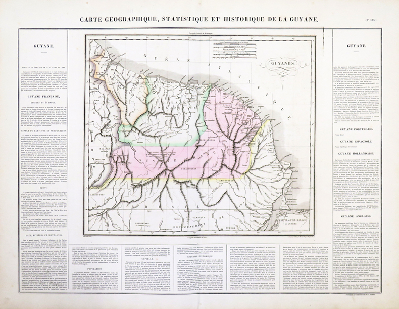
BUCHON (Jean Alexandre).
[GUYANE] Carte géographique, statistique et historique de la Guyane.
Paris, 1825. 473 x 616 mm.
Bookseller reference : LBW-4794
|
|
|
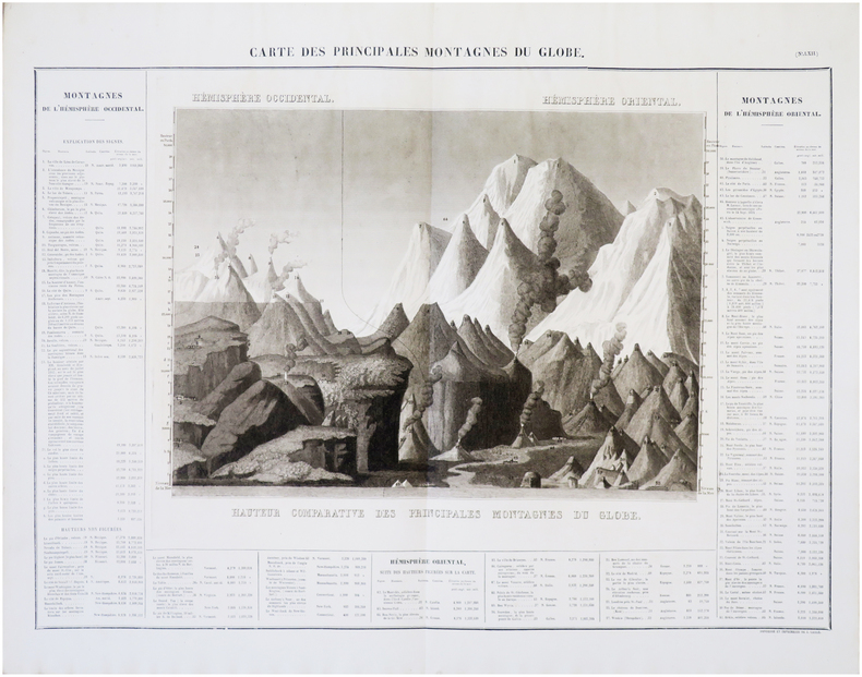
BUCHON (Jean Alexandre).
[MONTAGNES & RIVIÈRES] Carte des principales montagnes du globe [et] Carte des principales rivières du globe.
[Paris, 1825]. 460 x 648 mm et 468 x 635 mm.
Bookseller reference : LBW-7926
|
|
|
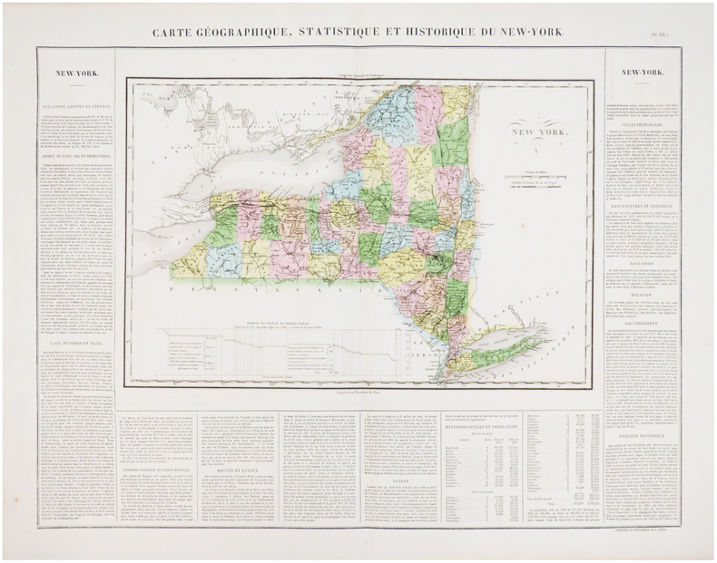
BUCHON (Jean Alexandre).
[NEW YORK] Carte géographique, statistique et historique du New-York.
[Paris, 1825]. 455 x 617 mm.
Bookseller reference : LBW03572
|
|
|
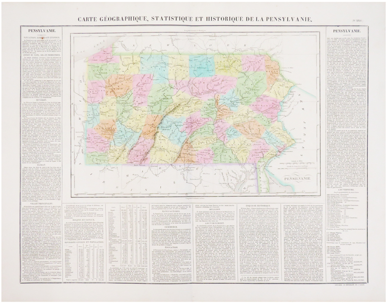
BUCHON (Jean Alexandre).
[PENNSYLVANIE] Carte géographique, statistique et historique de la Pensylvanie.
[Paris, 1825]. 456 x 612 mm.
Bookseller reference : LBW0358e
|
|
|
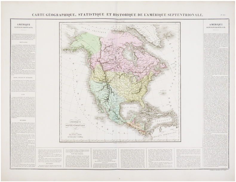
BUCHON (Jean Alexandre).
Carte géographique, statistique et historique de l'Amérique septentrionale.
[Paris, 1825]. 446 x 651 mm.
Bookseller reference : LBW0358d
|
|
|
BUCHON (Jean Alexandre);
Carte géographique, statistique et historique de l'Amérique méridionale.
Paris 1825 442 x 637 mm.
Bookseller reference : LBW03959
|
|
|
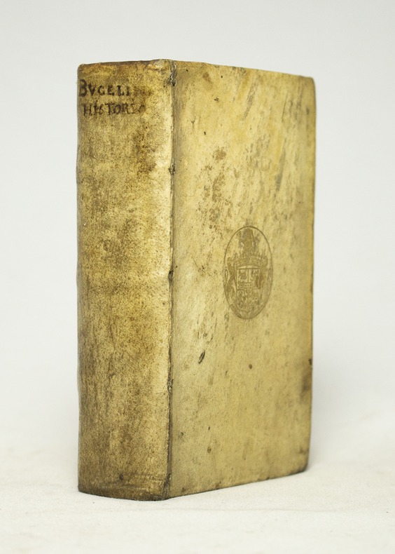
BUCELINO Gabriel:
Historiae universalis cum sacrae tum prophanae nucleus.
Ulmæ, Johannem Görlinum, 1652. In-12 de [542] pages non numérotées, plein vélin ivoire à rabats, titre manuscrit au dos et plats frappés des armes dorées de Louis-Henri de Loménie de Brienne.
Bookseller reference : 16628
|
|
|
BUCHOTTE
LES REGLES DU DESSIN ET DU LAVIS, POUR LES PLANS PARTICULIERS DES OUVRAGES ET DES BATIMENTS ET POUR LEURS COUPES, PROFILS, ELEVATIONS ET FACADES, TANT DE L'ARCHITECTURE MILITAIRE QUE CIVILE.
1754 1 volume, reliure de l'époque plein veau havane moucheté in-octavo (binding full calfskin in-octavo), dos à nerfs (spine with raised bands) décoré or (gilt decoration) filets et roulette or (fillets and gilt line) et filets à froid (blind-stamping line decoration) - entre-nerfs à fer spécial "Vase Antique" au fer plein (between the raised bands floweret with full blocking stamp) - titre frappé or (gilt title), pièce de titre sur fond bordeaux foncé (label of title) avec filet or (label of title with gilt line), coiffes manquantes (are missing the head and tail of the spine) Petit manque de cuir en coiffe et en queue sans gravité, plats légèrement épidermés (light scratches), charnière fendue (cracked joints) et coins écornés (corners dog-eared),tête lisse (top edge smooth), toutes tranches lisses (all smooth edges), orné de 24 planches dépliantes (folding plates) hors-texte (full page engraving) gravées sur bois (engraving wood) en noir, XV + 216 pages, 1754 Paris chez Charles Antoine Jombert Editeur,
Bookseller reference : 13722
|
|
|
Buchan, John.
THE LAST SECRETS. The Final Mysteries of Exploration.
303p. + Plus frontis, maps and photographs. 8vo. Original full cloth binding, somewhat soiled. The story of various explorations and discoveries with chapters on: Lhasa; the gorges of the Brahmaputra; the North Pole; the Mountains of the Moon; the South Pole, Mt. McKinley; the Holy Cities of Islam; the Exploration of New Guinea; and Mount Everest. **PRICE JUST REDUCED! POLAR 2
|
|
|
Buckham, A.F.
Nanaimo Coalfield (Coal Field) British Columbia (Map): Geological Survey Paper 47-22
38.5" x 26.75" map. Indicates sixty-seven coal mines and prospects. Extensive descriptive notes along right margin. Legend in left margin indicates the various formations shown on the map, including Gabriola, Northumberland, De Courcy, Cedar, Protection, Newcastle, Cranberry, Extension, Haslam and East Wellington, and Benson. Stored in original government-issued kraft envelope with some markings. Covers the area from Ladysmith Harbour north to Arbutus Point, south of Parksville. Includes most of Gabriola Island on the east and several miles inland from the coast on the west. Clean and unmarked with very light wear. A fascinating and highly-informative guide to the historic industry upon which Nanaimo was founded. An excellent vintage copy, most suitable for framing. Book

|
|
|
Buckheim E. S. Emma Sophia
HOLIDAYS AT SANDY BAY
London: Blackie 1911. No date but Copac gives 1911. 160 pages; 3 colour plates by A. E. Jackson. Publisher's decorative blue cloth blocked in red cream and black; a little rubbing slightly marked otherwise very good. Contents good and tight contemporary child's transfer to the front end paper stamped name a little spotting. A very good copy. Hardcover. Very Good. Illus. by Jackson A. E. 8vo. Blackie Hardcover
Bookseller reference : 025586

|
|
|
Buckley, J. A.
Geevor Mine
No marks or inscriptions. No creasing to covers. A very clean very tight copy with bright unmarked boards and no bumping to corners. 24pp. The story of Geevor Tin Mine in Cornwall. Glossary of mining terms at rear. Illustrated. We do not use stock photos, the picture displayed is of the actual book for sale. Every one of our books is in stock in the UK ready for immediate delivery.

|
|
|
BUFFON (Georges Louis Leclerc, comte de) & MARTINET (François-Nicolas).
1. Manakin à tête d'or. 2. Manakin à tête blanche. 3. Manakin rouge.
[Paris, 1771-1786]. 235 x 189 mm.
Bookseller reference : LBW-8246

|
|
|
BUFFON (Georges Louis Leclerc, comte de) & MARTINET (François-Nicolas).
1. Moineau franc, jeune. 2. Cardinal dominiquain.
[Paris, 1771-1786]. 230 x 187 mm.
Bookseller reference : LBW-8273

|
|
|
BUFFON (Georges Louis Leclerc, comte de) & MARTINET (François-Nicolas).
[AFRIQUE du SUD] 1. Hirondelle brune à collier, du Cap de Bonne-Espérance. 2. Hirondelle brune à tête rousse, du Cap de Bonne-Espérance.
[Paris, 1771-1786]. 220 x 173 mm.
Bookseller reference : LBW-8282

|
|
|
BUFFON (Georges Louis Leclerc, comte de) & MARTINET (François-Nicolas).
[CAROLINE] Tourterelle, de la Caroline.
[Paris, 1771-1786]. 230 x 178 mm.
Bookseller reference : LBW-8292

|
|
|
BUFFON (Georges Louis Leclerc, comte de) & MARTINET (François-Nicolas).
[GUYANE FRANÇAISE] 1. Tangara pourpré, de Cayenne. 2. Femelle du Tangara pourpré, de Cayenne.
[Paris, 1771-1786]. 235 x 181 mm.
Bookseller reference : LBW-8284

|
|
|
BUFFON (Georges Louis Leclerc, comte de) & MARTINET (François-Nicolas).
[GUYANE FRANÇAISE] Manakin, du Brésil. 2. Manakin orangé de Cayenne.
[Paris, 1771-1786]. 235 x 182 mm.
Bookseller reference : LBW-8277

|
|
|
BUFFON (Georges Louis Leclerc, comte de) & MARTINET (François-Nicolas).
[GUYANE FRANÇAISE] 1. Carouge, de Cayenne. 2. Carouge, du Cap de Bonne Espérance.
[Paris, 1771-1786]. 235 x 179 mm.
Bookseller reference : LBW-8280

|
|
|
BUFFON (Georges Louis Leclerc, comte de) & MARTINET (François-Nicolas).
[GUYANE FRANÇAISE] Manakin à tête noire, de Cayenne. 2. Manakin verd hupé, de Cayenne.
[Paris, 1771-1786]. 240 x 179 mm.
Bookseller reference : LBW-8278

|
|
|
BUFFON (Georges Louis Leclerc, comte de) & MARTINET (François-Nicolas).
[INDE] Perruche, de Gingi.
[Paris, 1771-1786]. 235 x 183 mm.
Bookseller reference : LBW-8286

|
|
|
BUFFON (Georges Louis Leclerc, comte de) & MARTINET (François-Nicolas).
[INDONÉSIE] Tourterelle à gorge pourprée, d'Amboine.
[Paris, 1771-1786]. 235 x 185 mm.
Bookseller reference : LBW-8287

|
|
|
BUFFON (Georges Louis Leclerc, comte de) & MARTINET (François-Nicolas).
[INDONÉSIE] Tourterelle, de Java.
[Paris, 1771-1786]. 235 x 178 mm.
Bookseller reference : LBW-8288

|
|
|
BUFFON (Georges Louis Leclerc, comte de) & MARTINET (François-Nicolas).
[INDONÉSIE/JAKARTA] Tourterelle, de Batavia.
[Paris, 1771-1786]. 225 x 175 mm.
Bookseller reference : LBW-8289

|
|
|
BUFFON (Georges Louis Leclerc, comte de) & MARTINET (François-Nicolas).
[INDE] 1. Le Bengali. 2. Le Bengali brun. 3. Le Bengali piqueté.
[Paris, 1771-1786]. 235 x 182 mm.
Bookseller reference : LBW-8291

|
|
|
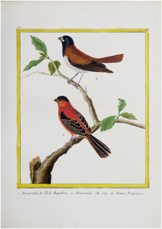
BUFFON (Georges Louis Leclerc, comte de) & MARTINET (François-Nicolas).
[LA RÉUNION] 1. Bouvreuil, de l'Isle Bourbon. 2. Bouvreuil, du Cap de Bonne Espérance.
[Paris, 1771-1786]. 235 x 185 mm.
Bookseller reference : LBW-8276
|
|
|
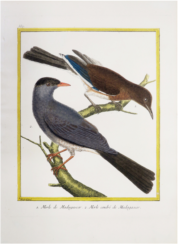
BUFFON (Georges Louis Leclerc, comte de) & MARTINET (François-Nicolas).
[MADAGASCAR] Merle de Madagascar. 2. Merle cendré de Madagascar.
[Paris, 1771-1786]. 232 x 179 mm.
Bookseller reference : LBW-8279
|
|
|
 Receive by email
 Download as PDF document
 RSS feed


