|
JEUX DE CARTES
Règle du je de Piquet - Piquet ordinaire - Piquet à écrire - Piquet normand - Piquet voleur - Lois et conventions.
Paris, Delarue, Paris, Delaruesd (v. 1890) ; in-12, broché, couverture jaune illustrée. 36 pp.Bel exemplaire.
Bookseller reference : 35503465
|
|
|
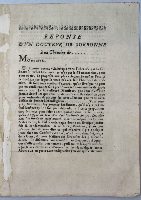
JEUX DE CARTES
Réponse d'un docteur de Sorbonnne à un chanoine de ...
(vers 1700).
Bookseller reference : 18195
|
|
|
JH. Parry; Illustrator Half tone illus diagrams prints Charts maps. B/W J. H.
The Age of Reconnaissance: Discovery Exploration and Settlement 1450 to 1650 Praeger History of Civilization Series
Praeger Publishers 1969. Hardcover. Good/edges are bent and nicked. Plast. Hardcover with dust jacket in good minus condition. spine is heavily stained. front and back cover have some light soiling. front and back inside cover's inner edge's are ripped. Binding is weak. Pages clean. Praeger Publishers hardcover
Bookseller reference : 043744
|
|
|
Jim Perry Blank Endpaper FORMER OWNER STAMP Illustrated By Photos Maps b/w
Stars Beyond The a Biographical Graveside Guide cemeteryS of Theda Bara Humphrey Bogart Bob Crane Marion Davies Sharon Tate Rudolph Valentino Peter Lorre Marilyn Monroe Bela Lugosi Errol Flynn Walt Disney Zazu Pitts Rosalind Russell ETC
Manhattan Beach CA Self-Published J. E. Perry 1978. Oblong Pictorial Paperback in B/W light creases Cover 1978 1st Edition Interior nice tight UNDERLINing Thruout VG/Good SOFTCOVER few notes in ink couple dog eared pgs . First Edition. Soft Cover. Manhattan Beach, CA Self-Published J. E. Perry paperback
Bookseller reference : 23100
|
|
|
JMD. Pringle Maps By Marthe Rajchman J. M.
China Struggles for Unity
Penguin 1939. 2nd Printing. Very Good book in a Fair dustjacket. Scarce paperback in dustjacket. Penguin unknown
Bookseller reference : 037805
|
|
|
Jo Sturges and Denise Laing (editors)
The Pub Guide 2004
No marks or inscriptions. No creasing to covers or to spine. A very clean very tight copy with bright unmarked boards, minor traces of storage to front cover and no bumping to corners. 704pp. The state of play with pubs which were open in 2004.

|
|
|
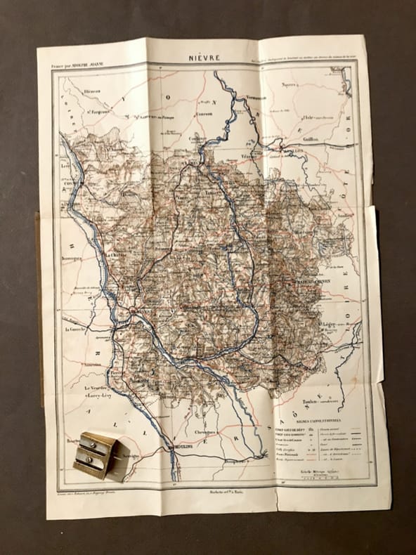
JOANNE (Adolphe)
Carte du département de la Nièvre.
Paris, Hachette, (circa 1900). 23,4 x 31,5 cm au cadre. Repliée sous une couverture petit in-12, toile beige de l'éditeur.
Bookseller reference : 21810
|
|
|
JOANNE (Adolphe)
Géographie de l'Allier
Paris, Librairie Hachette, 1908, 66 pp. in-12, rel. carto. édit, dos toilé bleu, ill. h.t 24 grav. et une carte coloriée h.t dépl.
Bookseller reference : 3807
|
|
|
JOANNE (Adolphe)
Géographie de l'Oise
Paris, Librairie Hachette, 1902, 60 pp. in-12, rel. carto. édit, dos toilé bleu, ill. h.t 13 grav. et une carte coloriée h.t dépl.
Bookseller reference : 3804
|
|
|
JOANNE (Adolphe)
Géographie de La Somme
Paris, Librairie Hachette, 1903, 68 pp. in-12, rel. carto. édit, dos toilé bleu, ill. h.t 11 grav. et une carte coloriée h.t dépl.
Bookseller reference : 3797
|
|
|
JOANNE (Adolphe)
Géographie des Hautes-Pyrénées
Paris, Librairie Hachette, 1897, 74 pp. in-12, rel. carto. édit, dos toilé bleu, ill. h.t 13 grav. et une carte coloriée h.t dépl.
Bookseller reference : 3811
|
|
|
JOANNE (Adolphe)
Géographie du Cantal
Paris, Librairie Hachette, 1895, 68 pp. in-12, rel. carto. édit, dos toilé bleu, ill. h.t 16 grav. et une carte coloriée h.t dépl.
Bookseller reference : 3814
|
|
|
JOANNE (Adolphe)
Géographie du département de l'Ariège
Paris, Librairie Hachette, 1896, 66pp. in-12, rel. carto. édit, dos toilé bleu, ill. h.t 12 grav. et une carte coloriée h.t dépl.
Bookseller reference : 3794
|
|
|
JOANNE (Adolphe)
Géographie du Loiret
Paris, Librairie Hachette, 1903, 68 pp. in-12, rel. carto. édit, dos toilé bleu, ill. h.t 27 grav. et une carte coloriée h.t dépl.
Bookseller reference : 3798
|
|
|
JOANNE (Adolphe)
Géographie du Lot
Paris, Librairie Hachette, 1879, 58 pp. in-12, rel. carto. édit, dos toilé bleu, ill. h.t 8 grav. et une carte coloriée h.t dépl.
Bookseller reference : 3796
|
|
|
JOANNE (Adolphe)
Géographie du Maine-et-Loire
Paris, Librairie Hachette, 1908, 70 pp. in-12, rel. carto. édit, dos toilé bleu, ill. h.t 17 grav. et une carte coloriée h.t dépl.
Bookseller reference : 3809
|
|
|
JOANNE (Adolphe)
Géographie du Nord
Paris, Librairie Hachette, 1904, 60 pp. in-12, rel. carto. édit, dos toilé bleu, ill. h.t 17 grav. et une carte coloriée h.t dépl.
Bookseller reference : 3805
|
|
|
JOANNE (Adolphe)
Géographie du Puy-de-Dôme
Paris, Librairie Hachette, 1911, 82 pp. in-12, rel. carto. édit, dos toilé bleu, ill. h.t 21 grav. et une carte coloriée h.t dépl.
Bookseller reference : 3813
|
|
|
JOANNE (Adolphe)
Géographie du Tarn-et-Garonne
Paris, Librairie Hachette, 1885, 60 pp. in-12, rel. carto. édit, dos toilé bleu, ill. h.t 8 grav. et une carte coloriée h.t dépl.
Bookseller reference : 3802
|
|
|
JOANNE Ad.
Carte du d?partement de la Manche au 1/440 000?. Sans date.
1 feuille sous couverture toil?e d?fra?chie. 25x35 cm.
|
|
|
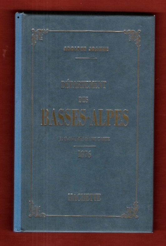
JOANNE Adolphe
Géographie Du Département Des Basses-Alpes . 11 Gravures & Une Carte Coloriée - 1876 . Complet De Sa Carte Dépliante En Couleurs
Paris Hachette 1993 In 12 Très belle iconographie reprenant les gravures des villages de l'époque . Guide Joanne . Cartes et plans . - 50 p. , 300 gr.
Bookseller reference : 009987
|
|
|
JOANNE Adolphe
Géographie Du Département Des Basses-Alpes . 11 Gravures & Une Carte Coloriée - 1876 . Complet De Sa Carte Dépliante En Couleurs
Très belle iconographie reprenant les gravures des villages de l'époque . Guide Joanne . Cartes et plans . - 50 p. , 300 gr.

|
|
|
JOANNE Adolphe
Nouveau plan de Paris
- Hachette, Paris 1867, 11x17,8cm, relié. - Collection des guides Joanne. Liste alphabétique des rues de Paris avec également la liste des omnibus et leurs trajets, les prix, les voitures mobiles et autres transports publics. Reliure d'éditeur en pleine percaline violette. Dos lisse muet. Titre et armes de Paris sur le premier plat. Grand plan dépliante de Paris en couleurs. Plusieurs petites déchirures. Bon exemplaire. Le Paris de Napoléon III et de Haussman. Ce plan de Paris a été édité pour l'exposition universelle de Paris de 1867. On lit à la fin du capitre sur les voitures publiques : "Un service spécial, de la place du Palais-Royal au pot d'Iena, aura lieu pendant toute la durée de l'exposition". [ENGLISH DESCRIPTION ON DEMAND]

|
|
|
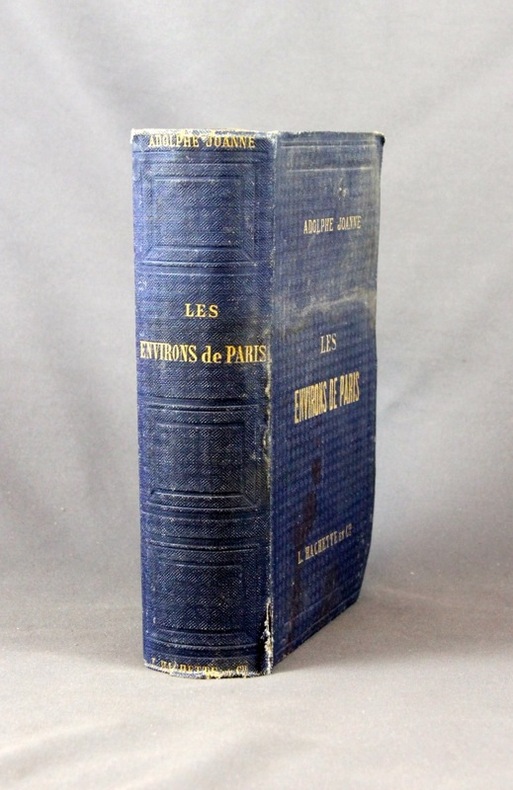
JOANNE Adolphe:
Les environs de Paris. Illustré. Itinéraire descriptif et historique.
Paris, Lib. de L. Hachette et Cie, [1856]. In-8 de XVI-847 pages, pleine percaline bleue d’éditeur, dos lisse orné de caissons à froid. Coiffes frottées, 1er plat taché, mors du 1er plat fendu en sa partie inférieure (3 cm), quelques rousseurs.
Bookseller reference : 2432
|
|
|
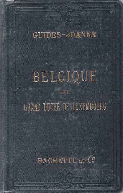
JOANNE Paul
Belgique et Grand-Duché De Luxembourg . Complet De Sa Carte Indépendante En Fin D'ouvrage
Paris Hachette & Cie 1894 In 16 Collection " Des Guides-Joanne " avec 15 plans et 7 cartes en couleurs dont certaines dépliantes . Nombreuses publicités , notamment d'hôtels mais aussi de Michelin , de chocolat Menier etc .- 312 p. + 118 p. , 550 gr.
Bookseller reference : 015242
|
|
|
JOANNE Paul
Belgique et Grand-Duché De Luxembourg . Complet De Sa Carte Indépendante En Fin D'ouvrage
Collection " Des Guides-Joanne " avec 15 plans et 7 cartes en couleurs dont certaines dépliantes . Nombreuses publicités , notamment d'hôtels mais aussi de Michelin , de chocolat Menier etc .- 312 p. + 118 p. , 550 gr.

|
|
|
Joanne Paul
Itinéraire général de la France - Bretagne
Hachette et Cie Toile d'éditeur In-12 (11x17.5 cm), reliure toile d'éditeur, auteur, titre et éditeur dorés sur le 1er plat et au dos, 30-(XXXII)-662 pages et 92 pages de publicités des Guides Joanne, cartes dépliantes en couleurs ; ors un peu passés au dos, coiffes un peu frottées, une pastille ronde au dos, certaines pages se détachent du dos, assez bon état. Livraison a domicile (La Poste) ou en Mondial Relay sur simple demande.
Bookseller reference : ys167
|
|
|
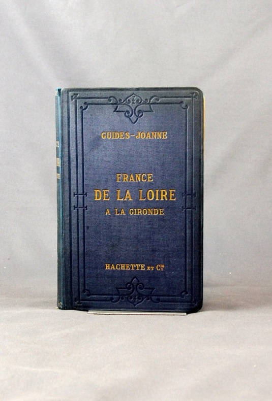
JOANNE Paul:
Itinéraire général de la France. (... ) De la Loire à la Gironde. Poitou et Saintonge.
Paris, Lib. Hachette et Cie, 1889. 1 vol. in-8 de 40, XXVI-259-126 pages, pleine percaline bleue d’éditeur, dos lisse orné à froid, plats encadrés à froid. Un mors fendu (1 cm), minuscules taches à la percaline, cahiers de publicité déboîtés mais solidaires.
Bookseller reference : 2433
|
|
|
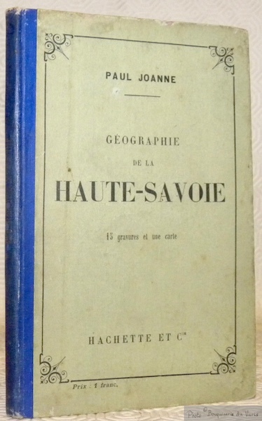
JOANNE, Adolphe.
Géographie du département de la Nièvre. Avec une carte coloriée et 15 gravures. Neuvième édition.
Paris, Librairie Hachette 1907 183x113mm, 65pages, cartonnage de l’éditeur. Bel exemplaire.
Bookseller reference : 63452
|
|
|
JOHANNE (Adolphe)
Géographie des Basses-Pyrénées
Paris, Librairie Hachette, 1894, 76 pp. in-12, rel. carto. édit, dos toilé bleu, ill. h.t 12 grav. et une carte coloriée h.t dépl.
Bookseller reference : 3799
|
|
|
John Anderson and Stearns Morse Illustrated by Black and White Photos maps
The Book of the White Mountians
New York: Minton Balch & Company 1930 1930 Green Cloth Gilt Titles. No Jacket. First. 300 pages. New York: Minton, Balch & Company, 1930 hardcover
Bookseller reference : 002520
|
|
|
John Anthony Caruso Francis J. Mitchell maps
The Great Lakes Frontier: A Epic of the Old Northwest
The Bobbs-Merrill Company Inc. Used - Good. Former Library book. Shows some signs of wear and may have some markings on the inside. The Bobbs-Merrill Company, Inc unknown
Bookseller reference : GRP79211165
|
|
|
John Bartholomew & Son Ltd Maps prepared by & printed by
Atlas of the World Franklin Library Special Edition prepared for The Royal Geographical Society of Times Atlas of the World
John Bartholomew & Son Ltd Maps prepared by & printed by Franklin Library nd c1987 Special Edition prepared for The Royal Geographical Society Times Atlas of the World Limited to 7500 copies full gilt decorated leather w/ribbed spine & gilt spine titles aeg silk end papers about fine no dj 228 pp w/index color map illus. folio $125.00 hardcover
Bookseller reference : 332189
|
|
|
John Bartholomew
Map of Spain and Portugal in Layer Colouring 1 : 1,600,000. (1943)
Clean map with two panes a little dusty, four inch tear along one fold and small holes to a few folding corners. 1pp. Linen-backed folded contour map dated 1943 opens up to 25 x 31 inches. Scale given on front cover of 1:6,000,000 is corrected inside as being 1:1,600.000. Date 1943 printed on lower map corner. Scarce.
|
|
|
John Betjeman
John Betjeman's Oxford
No marks or inscriptions. No creasing to covers or to spine. A very clean very tight copy with bright unmarked boards, slight sunning to spine, signs of storage and no bumping to corners. 192pp. Originally written in the 1930s, an unusual illustrated guide and history to the City of Oxford.

|
|
|
John Brick; Illustrator Maps on End Papers
Jubilee: A Novel About Sherman's Army
Doubleday & Co 1956-01-01. Hardcover. Very Good. Nice looking book has minor edge wear. Doubleday & Co hardcover
Bookseller reference : 1007300040
|
|
|
John Daly RN BA MEdHons BHScN PhD MACE AFACHSE FCN FRCNA; Sandra Speedy RN BAHons DipEd MURP EdN MAPS FANZCMHN; De
Contexts of Nursing: An Introduction
Churchill Livingstone 2005-10-18. Paperback. Good. Churchill Livingstone paperback
Bookseller reference : SONG0729537463 ISBN : 0729537463 9780729537469

|
|
|
John Daly RN BA MEdHons BHScN PhD MACE AFACHSE FCN FRCNA; Sandra Speedy RN BAHons DipEd MURP EdN MAPS FANZCMHN; De
Contexts of Nursing
Churchill Livingstone 2009-10-16. Paperback. Good. Churchill Livingstone paperback
Bookseller reference : SONG0729539253 ISBN : 0729539253 9780729539258
|
|
|
John Daly RN BA MEdHons BHScN PhD MACE AFACHSE FCN FRCNA Sandra Speedy RN BAHons DipEd MURP EdN MAPS FANZCMHN De
Nursing Leadership 1e
Churchill Livingstone 2003-11-15. Paperback. Used:Good. Churchill Livingstone paperback
Bookseller reference : DADAX0729537412 ISBN : 0729537412 9780729537414
|
|
|
John Daly RN BA MEdHons BHScN PhD MACE AFACHSE FCN FRCNA; Sandra Speedy RN BAHons DipEd MURP EdN MAPS FANZCMHN; De
Nursing Leadership
Churchill Livingstone 2003-11-01. Paperback. Good. Churchill Livingstone paperback
Bookseller reference : SONG0729537412 ISBN : 0729537412 9780729537414
|
|
|
John de Visser
Grand River Reflections
No marks or inscriptions. A lovely clean very tight copy with bright unmarked boards, very slight bumping to lower edge and no bumping to corners. Dust jacket not price clipped or marked or torn or creased. 155pp. A lavish photographic work giving some details of the history of the area from the Dundalk Highlands of Southern Ontario to Port Maitland on Lake Erie, beautifully enhanced by the superb colour images.. Very scarce in the UK.

|
|
|
John editor in chief; Bacheller Martin A. editor in chief for maps Denson
The Five Worlds of Our Lives: Ingredients and Results of War and Revolution
Newsweek Inc. and C.S. Hammond and Co. Inc. LEATHER BOUND. B0019W0M10 1961 Over sized leather bound volume. Text is clean binding is good covers have wear. . Good. Newsweek, Inc. and C.S. Hammond and Co., Inc. hardcover
Bookseller reference : SKU1004812
|
|
|
John Fraser Hart photos maps B&W illus Illustrator
Regions of the United States
Harper & RowPublishers 1972-01-01. Paperback. Used:Good. Harper & Row,Publishers paperback
Bookseller reference : DADAX0060426764 ISBN : 0060426764 9780060426767

|
|
|
John Fraser Hart; Illustrator photos maps B&W illus
REGIONS OF THE UNITED STATES
Harper & RowPublishers 1972. Paperback. Good. Harper & Row,Publishers paperback
Bookseller reference : SONG0060426764 ISBN : 0060426764 9780060426767
|
|
|
John J. Pershing; Illustrator Charts Many Fold Out Maps
Final Report of Gen. John J. Pershing Commander-in-Chief American Expeditionary Forces
Government Printing Office 1920. Paperback. Very Good. 8vo. Softcover. Good binding and cover. Chipping and loss to tail of spine. Minor wear to extremities. 95 p. 1l. : 16 pl. fold. maps diagrs. part fold. ; 24 cm. Contents: pt. 1. Period of organization; pt. 2. Operations; pt. 3. Supply coordination munitions and administration; pt. 4. Mscellaneous subjects. Clean unmarked pages with minimal toning. Foldout maps in crisp clean condition with no tears or excessive wear. Please feel free to view our photographs. Government Printing Office paperback
Bookseller reference : 1203080035
|
|
|
John Prebble
John Prebble's Scotland
No marks or inscriptions. A very clean very tight copy with bright unmarked unusual white card boards and no bumping to corners. Dust jacket not price clipped or marked or torn or creased with very slight traces of storage. 207pp. John Prebble's journey through the landscape of Scotland, through memory and history, spanning the Borders, the Highlands and the Isles. Illustrated in colour and in black & white.

|
|
|
John Speed
The Counties of Britain: A Tudor Atlas
No marks or inscriptions. Tiny crease to upper corner of rear covers and to lower part of spine. A very clean very tight copy with bright unmarked slightly indented boards and no bumping to corners. 288pp. Reproductions and discussion of the maps of every county of Britain done by John Speed, originally drawn and coloured just before and after the year 1600.

|
|
|
John Tauranac Tauranac Maps
Manhattan Block by Block: A Street Atlas
Map Link 2000-11-01. 1st. Mass Market Paperback. Used:Good. Map Link paperback
Bookseller reference : DADAX1878892126 ISBN : 1878892126 9781878892126
|
|
|
Johnsgard, Paul A.
Hummingbirds of North America
A clean, unmarked book with a tight binding. Full beige cloth boards. 7 1/8"h x 10 1/4"h. Small tears on dust jacket. 304 pages. Descriptions of 23 North American hummingbird species, 16 full-page color illustrations by James McClelland, distribution maps, glossary of technical terms, bibliography, identification keys, and more.

|
|
|
Johnson A. E.
Clarence and Corinne; or God's Way The Schomburg Library of Nineteenth-Century Black Women Writers
New York: Oxford University Press 1988. Very Good trade paperback. Trade Paper. Very Good. Oxford University Press paperback
Bookseller reference : 020502-C004 ISBN : 0195075773 9780195075779
|
|
 Receive by email
 Download as PDF document
 RSS feed


