|
|
|
Di Cocco,Ilaria. Pezzoli,Stefano (a cura di).
Il mazzo delle carte. L'informatizzazione dell'archivio cartografico e aerofotografico dell'IBC.
Un ricchissimo patrimonio di cartografia storica e fotografie aeree d'epoca, conservato nell'archivio dell'Istituto dei Beni Culturali, permette di ricostruire i principali cambiamenti del paesaggio e delle città dell'Emilia-Romagna negli ultimi tre secoli. Questo giacimento, raccolto in decenni di attività e da sempre consultabile nella sede dell'Istituto, è stato recentemente informatizzato per <br/> STATO: NUOVO.<br/> TITOLO: Il mazzo delle carte. L'informatizzazione dell'archivio cartografico e aerofotografico dell'IBC. <br/> AUTORE: Di Cocco,Ilaria. Pezzoli,Stefano (a cura di).<br/> CURATORE: Pubbl.dell'IStituto per i beni Artistici e Naturali della Regione Emilia Romagna.<br/> EDITORE: Editrice Compositori<br/> DATA ED.: 2012,<br/> COLLANA: Coll.IBC Immagini e Documenti.<br/> EAN: 97

|
|
|
Di Donna Valerio
Elementi di cartografia. Rappresentazioni della terra e dei suoi fenomeni
br.

|
|
|
Di Gregorio, A.
Technical Report on Land Cover Mapping of Lebanon.
<br/> STATO: USATO, MOLTO BUONO.<br/> NOTE: Lebanon land cover Maps<br/> TITOLO: Technical Report on Land Cover Mapping of Lebanon. <br/> AUTORE: Di Gregorio, A.<br/> CURATORE: FAO, Rome (Italy). Remote Sensing Centre.<br/> EDITORE: Food and Agriculture Organization of the United Nations.<br/> DATA ED.: 1991,<br/>
|
|
|
Di Macco Sergio, Mattera Pier Luigi.
L'INVENTARIO DEL TERRITORIO. Una nuova forma di catasto e di registrazione.
(Codice AC/3416) In 8° 287 pp. Brossura editoriale, stato di nuovo. ~~~ SPEDIZIONE IN ITALIA SEMPRE TRACCIATA

|
|
|
DIANE DORRANS SAEKS, ANGELIKA TASCHEN
Intérieurs de la cote .
Taschen sd 300 pages in 4 broché tres bon état ouvrage aux très nombreuses photos édité pour les 25 ans de la maison.
書籍販売業者の参照番号
: 9309
|
|
|
DIBENEDETTO, Giuseppe - TRISCIUZZI, Angelo Sante (a cura)
Dal casale alla città. Fasano nelle carte d'archivio dal XVII al XIX secolo. Guida alla mostra documentaria 1990
113 pagine con molte ill. nel testo, 24 cm. Brossura editoriale. Come nuovo. Timbro omaggio della Biblioteca
|
|
|
Dichter, B. / Grabois, A. [Preface]
The Maps of Acre: An Historical Cartography
Contains a map. 32.5x22.5 cm. 200 pages. Softcover. Cover slightly yellowing and slightly stained. Cover corners slightly wrinkled. Pages slightly yellowing and age stained. Else in good condition.
|
|
|
Diderot & D'Alembert.
GRAVURE EN LETTRES, EN GEOGRAPHIE ET EN MUSIQUE. Contenant deux planches. "Recueil de planches sur les sciences, les arts libéraux, et les arts mechaniques, avec leur explications".
(Codice AN/3406) Deux planches originales in folio (43x27 cm). Edition 1771, illustrée de nombreuses gravures par Bernard; avec 3 pags d'explication (très détaillées), texte sur deux colonnes. Sur papier pur chiffon à la cuve, grandes marges non rognés. Très bon état. Jointe photocopie de la page de titre du volume. ~~~ SPEDIZIONE IN ITALIA SEMPRE TRACCIATA

|
|
|
Diderot Denis
Viaggio in Olanda

|
|
|
DIDEROT et D'ALEMBERT
Recueil des planches sur les sciences, les arts libéraux, et les arts méchaniques, avec leur explication : Astronomie.
Paris, Inter-Livres, s.d. (ca 1980). 23 x 32, sans pagination, nombreuses planches et cartes, broché, bon état (couverture légèrement défraîchie).
書籍販売業者の参照番号
: 71236
|
|
|
DIGLIO Salvatore -
Cartografia minore e aree di confine nell'exclave pontificia di Benevento.
Firenze, 1997, 8vo stralcio con copertina posticcia muta, pp. 404/419 con illustrazioni fotografiche a colori. - !! ATTENZIONE !!: Con il termine estratto (o stralcio) intendiamo riferirci ad un fascicolo contenente un articolo, completo in se, sia che esso sia stato stampato a parte utilizzando la stessa composizione sia che provenga direttamente da una rivista. Le pagine sono indicate come "da/a", ad esempio: 229/231 significa che il testo è composto da tre pagine. Quando la rivista di provenienza non viene indicata é perché ci è sconosciuta. - !! ATTENTION !!: : NOT A BOOK : “extract” or “excerpt” means simply a few pages, original nonetheless, printed in a magazine. Pages are indicated as in "from” “to", for example: 229/231 means the text comprises three pages (229, 230 and 231). If the magazine that contained the pages is not mentioned, it is because it is unknown to us.

|
|
|
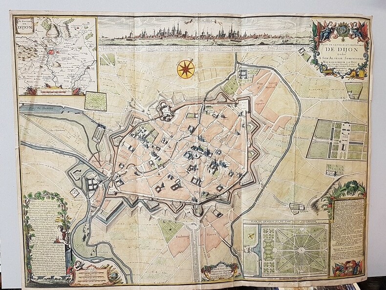
DIJON. GAMBU André
Plan de la Ville et des Environs de Dijon Dédié à Son Altesse Sérénissime Monseigneur le Duc par Son très humble et très Obbéissant Serviteur de Beaurain Géographe Ordinaire du Roy.-
Dessiné sur les lieux par André Gambu, arpenteur juré du Roy. Paris. Beaurain. Vers 1740. Grande carte (715 x 600 mm) richement coloriée à la main. Grand cartouche de titre historié, Description de Dijon, Grande vue en long de la ville avec noms des principaux lieux, Environs de Dijon, Plan du Château et du Parc de la Colombière présentés dans des cartouches diversement ornés. Réparation sans perte de 16 cm au dos d'un pli, sinon bon état. Photos sur demande.
書籍販売業者の参照番号
: ORD-18818
|
|
|
DIJOUD, J-C fécit.:
Nouvelle carte physique routière et administrative des Départements de la Savoie et Haute Savoie,
Chambéry, J. Perrin, libraire, éditeur et lithographe, 1865, 52x40 cm / 20x16 cm (plié), carte lithographiée n/b sur 9 feuilles papier montées sur toile, signé „J.-C. Dijoud Fecit“, échelle: 1:320’000, pièce de titre lithgraphiée originale „Savoie et Hte Savoie“ au verso, toile légèrement usée sur les coins, sinon bon état.
書籍販売業者の参照番号
: 111513aaf
|
|
|
DINOVO Girolamo (attivo a Roma fine XVI secolo)
Ferrara
In alto a destra, in un cartiglio, troviamo il titolo: FERRARA. Nell’angolo superiore sinistro è rappresentato lo stemma di Clemente VIII. In basso a sinistra, in un cartiglio a forma di basamento di colonna, la dedica: All’ill.mo e Rever mo Sig re e Pat ne Col mo il S r Cardi le S giorgio Grande e la virtu del disengno Poiche puo Rappresentarci Avanti a gli occhi anco le cose lo[n]tane con la forza sua mi trovo haver Ritratto La cita di Ferrara Ricuperata hoggi felicimente da N.S. Clemente Ottavo A.S. chiesa onde per segno de la devotion mia la Dedico A. V.S. ill ma scusandomi della Piccolezza del doNo e pregandolae Prosperita Conforme a suoi Nobilissimi pensieri in Roma a di 29 di Gennaro 1598 D.V.S, ill ma e Rever ma Devoti mo et humil mo servitore Gerolamo dinovo. A destra del basamento si legge: La ciTa di Ferrara è situata per latitudine G di 43 Per longitudine Gradi 33 Rivista dil S.Gioseppe Capocacia. Pianta prospettica della città incisa da Girolamo Dinovo e, come dichiarato nella tavola, “rivista” da Giuseppe Capocaccia. Si tratta della più antica rappresentazione prospettica di Ferrara dalla quale derivano tutte le successive fino al nuovo rilievo di Andrea Bolzoni (1647). La pianta fu realizzata in occasione della devoluzione del ducato di Ferrara alla S. Sede, nel gennaio del 1598; in alto a sinistra reca, infatti, lo stemma di papa Clemente VIII, al secolo Ippolito Aldobrandini, celebrato per aver recuperato il ducato allo Stato pontifico. In basso a destra, la dedica al cardinale Giovanni Francesco Blandrate di S. Giorgio.Il primo stato della lastra, avanti l’indirizzo dell’Orlandi e la data 1602, è sconosciuto a tutti i repertori consultati sulla città di Ferrara; ne consegue che la tavola successiva, di Matteo Florimi, che è una chiara e puntuale derivazione di questa, ne venga considerata il prototipo. Benevolo, nel descrivere la copia del Florimi, sottolinea che l’orientamento è scelto in modo tale che la città medievale, con l’asse est-ovest rettificato e disposto in orizzontale, serva da basamento alla città moderna, l’Addizione Erculea. La proiezione obliqua, aumentando la scala degli edifici più densi in primo piano e diminuendo quella degli edifici più radi nello sfondo, rende prospetticamente uniformi le due zone, e presenta l’immagine di una città unitaria, sebbene non riproduca fedelmente la realtà. Il fiume che corre nella parte inferiore, è solo uno dei bracci secondari del Po, che in questo punto si bifora per perdersi nelle valli costiere; ma nell’alto medioevo era uno dei bracci principali, e lungo il suo argine si è formato il primo nucleo della città. La lastra, stampata a Roma come enunciato nel cartiglio, non reca indicazioni editoriali. Probabilmente fu edita da Giacomo Gherardi, erede e successore della calcografia di Claudio Duchetti. Che la lastra fosse appartenuta al Gherardi è dimostrato dalla presenza dell’opera nel catalogo della vedova dell’editore, Quintilia Lucidi, del 17-19 ottobre 1598 (n. 424 descritta come “la Citta di Ferrara”). La matrice venne acquisita, nel 1602, da Giovanni Orlandi che la ristampò inalterata con la sola aggiunta del proprio imprint. Nel 1614, con il trasferimento di Orlandi a Napoli, la matrice fu ceduta a Hendrick van Schoel. Giuseppe Capocaccia è forse da identificarsi con il matematico e ingegnere militare di Senigallia che lavorò al servizio di Filippo IV. Girolamo Dinovo o Di Novo, cartografo attivo nel XVI secolo, conosciuto per la carta senza titolo raffigurante il territorio di Ferrara. Del Dinovo, Almagià (1922, p. 25) cita anche una pianta di Ferrara edita a Roma nel 1598. Giacomo Gherardi è stampatore, tipografo e editore originario di Carmagnola, in Piemonte. Attivo a Roma, lavorò per Lorenzo Vaccari e poi per Claudio Duchetti. Nel 1589 fu descritto come “dominus lacobus Gerardus venditor imaginum nella regione Parionis”. La sorella di Gherardi, Margherita, sposò Clau... At the top right, in a cartouche, we find the title: FERRARA. In the upper left corner is represented the coat of arms of Clement VIII. In the lower left corner, in a cartouche in the form of a column base, the dedication: All'ill.mo e Revermo Sig re e Pat ne Col mo il S r Cardi le S giorgio Grande e la virtu del disengno Poiche può Rappresentarci Avanti a gli occhi anco le cose lo[n]tane con la forza sua mi trova haver Ritratto La cita di Ferrara Ricuperata hoggimente felicimente da N. S Clemente Ottavo A.S. chiesa onde per segno de la segno di Ferrara. S. Clemente Ottavo A.S. church onde per segno de la devotion mia la Dedico A. V.S. ill ma scusandomi della Piccolezzazza del doNo e pregandolae Prosperita Conforme a suoi Nobilissimi pensieri in Roma a di 29 di Gennaro 1598 D.V.S, ill ma e Rever ma Devoti mo et humil mo servitore Gerolamo dinovo. To the right of the base we read: La ciTa di Ferrara è situata per latitudine G di 43 Per longitudine Gradi 33 Rivista dil S.Gioseppe Capocacia. Perspective plan of the city engraved by Girolamo Dinovo and, as stated in the table, "revised" by Giuseppe Capocaccia. This is the oldest representation of Ferrara from which all the subsequent ones derive until the new relief by Andrea Bolzoni (1647). The plan was made on the occasion of the devolution of the Duchy of Ferrara to the Santa Sede, in January 1598. At the top left is the coat of arms of Pope Clement VIII, born Ippolito Aldobrandini, celebrated for having recovered the Duchy to the Papal States. The first state of the plate, in front of the address of Orlandi and the date 1602, is unknown to all the repertories consulted on the city of Ferrara; it follows that the next plate, by Matteo Florimi, which is a clear and precise derivation of this one, is considered the prototype. Benevolo, in describing the copy by Florimi, underlines that the orientation was chosen so that the medieval city, with its east-west axis straightened and placed horizontally, would serve as a base for the modern city, the Addizione Erculea. The oblique projection, by increasing the scale of the denser buildings in the foreground and decreasing that of the sparser buildings in the background, makes the two areas uniform in perspective, and presents the image of a unitary city, although it does not faithfully reproduce reality. The river that runs in the lower part, is only one of the secondary arms of the Po, that in this point bifurcates to get lost in the coastal valleys; but in the high Middle Ages it was one of the main arms, and along its bank was formed the first nucleus of the city. The plate, printed in Rome as stated in the cartouche, does not bear editorial indications. It was probably edited by Giacomo Gherardi, heir and successor to the chalcography of Claudio Duchetti. That the plate belonged to Gherardi is demonstrated by the presence of the work in the catalog of the widow of the publisher, Quintilia Lucidi, dated October 17-19, 1598 (n. 424 described as “la Citta di Ferrara”). The plate was acquired, in 1602, by Giovanni Orlandi who reprinted it unchanged with the addition of his own imprint. In 1614, when Orlandi moved to Naples, the plate was bought by Hendrick van Schoel. Giuseppe Capocaccia is perhaps to be identified with the mathematician and military engineer of Senigallia who worked in the service of Philip IV. Girolamo Dinovo or Di Novo, cartographer active in the sixteenth century, known for the untitled map depicting the territory of Ferrara. Giacomo Gherardi was a printer, typographer and publisher from Carmagnola, in Piedmont. Active in Rome, he worked for Lorenzo Vaccari and then for Claudio Duchetti. In 1589 he was described as "dominus lacobus Gerardus venditor imaginum in the region Parionis". Gherardi's sister, Margherita, married Claudio Duchetti. After Claudio's death in 1585, Gherardi was supposed to run the print shop business until Duchetti's son turned 18; if the child died Gherardi would inherit it. Howev...

|
|
|
Diolé Philippe
L'avventura sottomarina
illustrazioni

|
|
|
Dionigi,Renzo.
Insubres et Insubria nella cartografia antica.
<br/> STATO: USATO, MOLTO BUONO.<br/> TITOLO: Insubres et Insubria nella cartografia antica. <br/> AUTORE: Dionigi,Renzo.<br/> EDITORE: Nicolini Ed.<br/> DATA ED.: 2000,<br/> EAN: 9788886623056
|
|
|
Dir. mostra: Ruaro Luseri Laura - Catalogo a cura: Caputo Fulvio.
Le Carte dell'Impero. La cartografia tra amministrazione e tecnica: Trieste nel Settecento. Trieste, 23 settembre/30 ottobre 1982.
Bross., cm 30x21, pp 120, ill. a col. e b/n.. - ISBN: 8876460047

|
|
|
Dirk Imhof,Iris Kockelbergh Co-auteur: Jan Parmentier Ad Meskens
Mercator: Exploring New Horizons
, BAI, 2012 softcover, 124 pag. 26x21cm, Illustrated. ISBN 9789085866299.
書籍販売業者の参照番号
: 57996
|
|
|
Dirk Imhof,Iris Kockelbergh Co-auteur: Jan Parmentier Ad Meskens
Mercator: Exploring New Horizons
softcover, 124 pag. 26x21cm, Illustrated. ISBN 9789085866299. The European perspective opened up markedly in the sixteenth and seventeenth centuries as a whole new world unfolded. Explorers, traders and diplomats committed their travelling experiences to paper in journals and reports. They sketched out their impressions of recently discovered territories, making it possible for us today to see how they viewed other cultures at that time. These travel narratives may have been embroidered with a certain degree of fantasy at times, nevertheless, they also frequently provided precise descriptions of exotic regions. They were important sources of information for cartography, which underwent an explosive evolution as a result. Navigational knowledge also grew considerably as a consequence of the traveller's urge to explore. After all, maritime expansion on a vast scale led to a need for new techniques and instruments in order to reach destinations quickly and safely. The development of cartography, in which Gerard Mercator played a pivotal role, was in turn responsible for expanding the mobility of Europeans as a whole. It was not uncommon for adventurous sixteenth-century travellers to embark on lengthy journeys as part of a trade mission or in connection with their education. One such young adventurer was Balthasar III Moretus. He made several journeys throughout Europe, including one to Italy, and kept journals of his observations on the way. Mercator: Exploring New Horizons maps out literally and figuratively this fascinating period of interplay between European travelling behaviour and the development of cartography.

|
|
|
Distributed by A. M. KARMI.
[CHROMOLITHOGRAPHED ATLAS BY GERMAN PUBLISHING HOUSE FOR THE OTTOMAN MARKET] Ilk ve orta mekteblere mahsûs cografya atlasi. Distributed by A. M. Karmi.
Very Good Turkish, Ottoman (1500-1928) Original bdg. 4to. (28 x 24 cm). In Ottoman script (Old Turkish with Arabic letters). 24 p. First and only edition of this scarce atlas printed in Leipzig for the Ottoman market before the proclamation of the Republic, distributed by Jewish agent A. M. Karmi of this atlas located in Dersaadet (Constantinople), including beautiful and attractive 34 chromo-lithographed maps of Africa, Australia, Americas, Europe, Turkey, Asia, and a celestial map. Özege 8803.; Only two copies in OCLC: 632952950, 949536147 (the Bogaziçi University of Turkey and Universitätsbibliothek Bamberg of Germany).
|
|
|
Diverse auteurs
Annalen van de Koninklijke Oudheidkundige Kring van het Land van Waas, deel 97 (1994): Speciaal Mercator-nummer ter gelegenheid van het Mercatorjaar
Sint-Niklaas, 1994 464pp. geïllustreerd met o.m. 68 kaarten in zw/w en 1 kaart in kleur, 24cm., goede staat, B82481
書籍販売業者の参照番号
: B82481
|
|
|
Diverse auteurs
Annalen van de Koninklijke Oudheidkundige Kring van het Land van Waas, deel 97 (1994): Speciaal Mercator-nummer ter gelegenheid van het Mercatorjaar
464pp. geïllustreerd met o.m. 68 kaarten in zw/w en 1 kaart in kleur, 24cm., goede staat, B82481
|
|
|
Diverse auteurs
Kaart van Gelderland - schaal 1 : 160 000
Bussum, J.A. Sleeswijk, oorspronkelijk gevouwen kaart intact/ compleet en in goede staat.
書籍販売業者の参照番号
: 61676
|
|
|
Diverse auteurs / collectif
Annalen van den oudheidskundigen kring van het Land van Waas 9e deel 2e afl. juni 1883 / Annales du cercle archéologique du pays de Waas 9e tome 2e livr. juin 1883
Sint-Nikolaas, J. Edom 1883 59pp., 28cm., br.orig., non-coupé, bilingue / tweetalig: Nederlands-français, [bevat / contient: J.V.R., La grande carte de Flandre par Gérard Mercator (1540), pp.173-208 & J.V.R., Het armmeesterschap te Sint-Nikolaas in vorige tijden, pp.209-217]
書籍販売業者の参照番号
: B67317
|
|
|
Diverse auteurs / collectif
Annalen van den oudheidskundigen kring van het Land van Waas 12e deel 3e afl. januari 1890 / Annales du cercle archéologique du pays de Waas 12e tome 3e livr. janvier 1890
Saint-Nicolas, J. Edom 1890 122pp. + 1 planche hors-texte, 28cm., brochure originale (dos restauré), bilingue / tweetalig: Nederlands-français, [bevat / contient: VAN NAEMEN Felix, L'épitaphier Wasien. Inscriptions de Melsele no.656-754, de Cruybeke no.755-794, de Calloo no.795-817, pp.219-296 & VAN RAEMDONCK, Gérard Mercator Rupelmondois et non Anversois, pp.297-310 & VAN RAEMDONCK, Découverte de deux premiers exemplaires connus de la grande carte d'Europe (1554) et de la carte des îles Britanniques (1564) de Gérard Mercator, pp.311-330], B67327
書籍販売業者の参照番号
: B67327
|
|
|
Diverse auteurs / collectif
Annalen van den oudheidskundigen kring van het Land van Waas 9e deel 2e afl. juni 1883 / Annales du cercle archéologique du pays de Waas 9e tome 2e livr. juin 1883
59pp., 28cm., br.orig., non-coupé, bilingue / tweetalig: Nederlands-français, [bevat / contient: J.V.R., La grande carte de Flandre par Gérard Mercator (1540), pp.173-208 & J.V.R., Het armmeesterschap te Sint-Nikolaas in vorige tijden, pp.209-217]
|
|
|
Diverse auteurs / collectif
Annalen van den oudheidskundigen kring van het Land van Waas 12e deel 3e afl. januari 1890 / Annales du cercle archéologique du pays de Waas 12e tome 3e livr. janvier 1890
122pp. + 1 planche hors-texte, 28cm., brochure originale (dos restauré), bilingue / tweetalig: Nederlands-français, [bevat / contient: VAN NAEMEN Felix, L'épitaphier Wasien. Inscriptions de Melsele no.656-754, de Cruybeke no.755-794, de Calloo no.795-817, pp.219-296 & VAN RAEMDONCK, Gérard Mercator Rupelmondois et non Anversois, pp.297-310 & VAN RAEMDONCK, Découverte de deux premiers exemplaires connus de la grande carte d'Europe (1554) et de la carte des îles Britanniques (1564) de Gérard Mercator, pp.311-330], B67327
|
|
|
DOINO Catarino (att. Prima metà del XVII sec.)
Descrizione della Valetelina et Chiavena con suoi confini
- 2 ESEMPLARI NOTI -Rarissima carta, che copre il territorio della Valtellina e parte dei territori limitrofi: Stato di Milano a ovest, Grigioni a nord, Contado del Tirolo a est e Signoria di Venezia a sud.Sulla mappa sono segnate la "Strada di S. Venetiani" che conduce da Morbegno al passo della Casa di San Marco e quella di "Ciapei de uriga/Stradon de Venetiani", che conduce al passo dell'Aprica, particolare di grande rilievo perché mostra con chiarezza gli itinerari degli eserciti e dei traffici commerciali dell'epoca.Orientata con il Nord in alto, non datata, la carta non è molto accurato sotto il profilo orografico e idrografico. Altro particolare interessante e utile ai fini della datazione della mappa, è il fatto che sulla mappa sia segnato il paese di Piuro, che fu colpito e cancellato da una frana il 4 settembre del 1618. Pertanto, si può ipotizzare che o la carta sia stata incisa prima del settembre 1618 o che, se anche incisa dopo, abbia seguito un modello cartografico in cui Piuro era ancora legittimamente riportato.La Bianchi ritiene verosimile che il modello sia la famosa carta di Klüver e Sprecher del febbraio 1618. Nel cartiglio in basso al centro, è contenuta la dedica a Giambattista Gambara, uomo di lettere e mecenate, condifente della Repubblica Veneta ma anche del Marchese di Bedmar, ambasciatore di Spagna.La carta è di estrema rarità: i soli esemplari censiti nelle raccolte pubbliche sono quelli conservati presso la Civica Raccolta delle Stampe "Achille Bertarelli", a Milano (mutilo della parte infeirore) e quello nella raccolta cinquecentesca della Biblioteca Universitaria Alessandrina di Roma, che ha una coloritura coeva molto simile a questo esemplare.Incisione su rame, coloritura coeva, restauro perfettamente eseguiot all'angolo inferiore sinistro, per il resto in ottimo stato di conservazione. - 2 ESEMPLARI NOTI -Rarissima carta, che copre il territorio della Valtellina e parte dei territori limitrofi: Stato di Milano a ovest, Grigioni a nord, Contado del Tirolo a est e Signoria di Venezia a sud.Sulla mappa sono segnate la "Strada di S. Venetiani" che conduce da Morbegno al passo della Casa di San Marco e quella di "Ciapei de uriga/Stradon de Venetiani", che conduce al passo dell'Aprica, particolare di grande rilievo perché mostra con chiarezza gli itinerari degli eserciti e dei traffici commerciali dell'epoca.Orientata con il Nord in alto, non datata, la carta non è molto accurato sotto il profilo orografico e idrografico. Altro particolare interessante e utile ai fini della datazione della mappa, è il fatto che sulla mappa sia segnato il paese di Piuro, che fu colpito e cancellato da una frana il 4 settembre del 1618. Pertanto, si può ipotizzare che o la carta sia stata incisa prima del settembre 1618 o che, se anche incisa dopo, abbia seguito un modello cartografico in cui Piuro era ancora legittimamente riportato.La Bianchi ritiene verosimile che il modello sia la famosa carta di Klüver e Sprecher del febbraio 1618. Nel cartiglio in basso al centro, è contenuta la dedica a Giambattista Gambara, uomo di lettere e mecenate, condifente della Repubblica Veneta ma anche del Marchese di Bedmar, ambasciatore di Spagna.La carta è di estrema rarità: i soli esemplari censiti nelle raccolte pubbliche sono quelli conservati presso la Civica Raccolta delle Stampe "Achille Bertarelli", a Milano (mutilo della parte infeirore) e quello nella raccolta cinquecentesca della Biblioteca Universitaria Alessandrina di Roma, che ha una coloritura coeva molto simile a questo esemplare.Incisione su rame, coloritura coeva, restauro perfettamente eseguiot all'angolo inferiore sinistro, per il resto in ottimo stato di conservazione. Almagià, p. 57; Perini, p. 71; S. Bianchi, Valtellina Valchiavenna e Grigioni sotto la lente , n. 38 p. 131. Sconosciuta allo Schaffer.

|
|
|
Doll, M
Vorlageblätter zum Planzeichnen bearbeitet für d. Unterricht an Technischen Lehranstalten.
Stuttgart, Metzler`sche Buchh. 1873. Fol. 11 (teils farb.) doppelblattgr. Taf. 14 S. Text. OHlwd. Einbd. angeschmutzt u. leicht angerissen sowie m. Sign. Vors. etwas stockfl., m. kl. Anriss an Bind. u. kl. Sign. Teils etwas randgebräunt. St. u. Sign. a. Tit.
書籍販売業者の参照番号
: 160611
|
|
|
Domenico Cogliandro
La rappresentazione della città. Carte tematiche e piani urbanistici
Autori: Domenico Cogliandro, Daniele Colistra.

|
|
|
DOMINI Giuseppe -
Dal terreno alla carta: un addestramento al disegno cartografico della roccia.
Firenze, IGM, 1977, 8vo stralcio con copertina posticcia muta, pp. 305/336 completamente illustrato da carte e fotografie, in nero e a colori. - !! ATTENZIONE !!: Con il termine estratto (o stralcio) intendiamo riferirci ad un fascicolo contenente un articolo, completo in se, sia che esso sia stato stampato a parte utilizzando la stessa composizione sia che provenga direttamente da una rivista. Le pagine sono indicate come "da/a", ad esempio: 229/231 significa che il testo è composto da tre pagine. Quando la rivista di provenienza non viene indicata é perché ci è sconosciuta. - !! ATTENTION !!: : NOT A BOOK : “extract” or “excerpt” means simply a few pages, original nonetheless, printed in a magazine. Pages are indicated as in "from” “to", for example: 229/231 means the text comprises three pages (229, 230 and 231). If the magazine that contained the pages is not mentioned, it is because it is unknown to us.

|
|
|
Dompé, Carlo
Guida del viaggiatore italiano in Francia all'Esposizione del 1900
16 cm, pp. 282, 4 tavole ripiegate fuori testo, alcune figure nel testo. Rilegatura editoriale in piena tela, titolo al dorso e incorniciato al piatto. Ex libris privato applicato al contropiatto, esemplare ottimo

|
|
|
DONKERSLOOT-DE VRIJ
KAARTEN VAN UTRECHT
Gebonden, 142pp. ISBN 9789061942078. Topografische En Thematische Kartografie Van de Stad Uit Vijf Eeuwen. Nieuw.
|
|
|
DONKERSLOOT-DE VRIJ
PLATTEGROND VAN UTRECHT
Paperback, 38pp. ISBN 9789061940647. ... verschenen bij N. van der Monde, 1839. Nieuw.
|
|
|
DONKERSLOOT-DE VRIJ,
KAARTEN VAN UTRECHT,
Antwerpen , De Vries - Brouwers, Gebonden, 142pp. ISBN 9789061942078.
書籍販売業者の参照番号
: 30051
|
|
|
DONKERSLOOT-DE VRIJ,
PLATTEGROND VAN UTRECHT,
Antwerpen , De Vries - Brouwers, Paperback, 38pp. ISBN 9789061940647.
書籍販売業者の参照番号
: 30052
|
|
|
DORE OGRIZEK
L'Afrique du nord.
Editions ODE, 1952, avants-propos de Pierre Mac Orlan, textes de Marcel Sauvage et Hubert Deschamps, 1952, 460 pages, in 12 reliure éditeur cartonnée et toilée, titres or, bon état, dos légèrement insolé.
書籍販売業者の参照番号
: 12730
|
|
|
DORE OGRIZEK
Paris, la France et les provinces.
Ode Paris, 1949, 461 pages, illustrations de Pilon, Firsca, Grau sala, Beuville, De Sainte Croix, gastronomie P.Andrieu, in 12 reliure éditeur cartonnée, bon état.
書籍販売業者の参照番号
: 10093
|
|
|
DORE OGRIZEK ROGER ROUMAGNAC PIERRE ANDRIEU
La France, Paris et L'Ile de France.
Odé Paris, sans date, 253 pages, in 12 reliure éditeur cartonnée, état moyen, rousseurs, coiffes abimées, mors et charnière fatigés, illustrations de Beuville, Fircsa, Pilon, Grau-Sala de Sainte Croix.
書籍販売業者の参照番号
: 10448
|
|
|
Dorpfeld, W. ; Wilberg, W.
[Plan of Ancient Troy] Plan of Troy ; Plan von Troja ; Plan de Troie ; Pianta Troia
23.5x12.5 cm. A folding map. Softcover. Pages slightly yellowing. Else in good condition.
|
|
|
Douglas William O.
Fermenti in Medio Oriente
illustrazioni

|
|
|
Dourado Fernao Vaz
Regni Terre Isole. Atlante nautico di F. V. D. 1580. Commento di Luisa Pranzetti
riproduzione in fac-simile dell'esemplare conservato alla Bayerische Staatsbibliothek di Monaco. Bellissima la riproduzione delle tavole dell'Amrica del Nord, Centrale e del Sud. Dell'Africa. dell'Asia frontespizio e 15 tavole a doppia pag. a colori f.t., bellissima la riproduz. delle tavole
|
|
|
DR FRED BLANCHOD
La randonnée africaine.
Librairie Payot, 1946, 277 pages + 32 illustrations et 1 carte, in 8 broché, bon état, exemplaire de bibliothèque.
書籍販売業者の参照番号
: 10188
|
|
|
DR. ANDRE MIGOT
Visages de la Chine éternelle.
1964 Connaissance de l'Asie, Société Continentale d'Editions Modernes Illustrées, Bibliophiles de l'Aventure,1964, 369 pages, 64 planches hors texte en héliogravure, 20 cartes et croquis, et 8 planches hors texte couleurs, grand in 8 reliure éditeur cartonnée et toilée bleue, motifs sur le 1er plat, titres or, bon état, quelques petites rousseurs sur tranches , tranches jaunies, avec rodhoïde.
書籍販売業者の参照番号
: 14561
|
|
|
DR. DE AZPILIKOETA
Le problème basque.
1938 Grasset, 1938, 244 pages, in 8 broché couverture semi-rigide, état d'usage, insolé, papier jauni (rousseurs), quelques usures et frottements sur les coiffes, les bords des plats et le dos, coins légèrement cornés.
書籍販売業者の参照番号
: 15198
|
|
|
DR. HÜSEYIN DAGTEKIN.
Bizde tarih haritaciligi ve kaynaklari üzerine bir arastirma. VIII. T.T.K. Kongresinde okunan bildiri.
Very Good Turkish Paperback. Roy. 8vo. (24 x 17 cm). In Turkish. 39 p. Bizde tarih haritaciligi ve kaynaklari üzerine bir arastirma. VIII. T.T.K. Kongresinde okunan bildiri. A fine source on Turkish / Islamic maps and mapmakers.
|
|
|
DR. KARL SOHR (Hrsg.; Ed.): VOLLSTÄNDIGER HAND-ATLAS DER NEUEREN ERDBESCHREIBUNG ÜBER ALLE THEILE DER ERDE IN 80 BLÄTTERN + SUPPLEMENT-BAND . .: Sonne
'VOLLSTÄNDIGER HAND-ATLAS DER NEUEREN ERDBESCHREIBUNG ÜBER ALLE THEILE DER ERDE IN 80 BLÄTTERN', herausgegeben von Dr. K. Sohr: - FORTSETZUNG der Karten / Continuation from below: Nordöstliches Frankreich; Nordwestliches -; Südöstliches -; Südwestliches -; Spanien und Portugal; Nordöstliches Spanien; Südöstliches -; Nordwestliches Spanien mit Portugal; Südwestl. Spanien mit Portugal; Grossbritannien und Irland; England; Schottland; Irland; Holland und Belgien; Dänemark; Schweden und Norwegen; Nördliches Schweden und Norwegen; Südliches Schweden; Europäisches Russland; Europäische Türkei; Griechenland; Asien; Asiatisches Russland (Sibirien); Westliches Hochasien; Vorderindien; Ostindische Inseln; Asiatische Türkei; China; Africa; Nordamerika; Nordamerik. Freistaaten; Mexiko; Westindien; Südamerika; Australien; Australland.* / 'SUPPLEMENTBAND ZUM HAND-ATLAS . . .'[32 KARTEN]: . . . (Fortsetzung weiter unten / see below: >) [Nordamerikanische Freistaaten, Texas, Nordamerika, Australia]
GLOGAU - LEIPZIG, DRUCK U. VERLAG VON C. FLEMMING, 1844/1847. --- FORTSETZUNG der Tafeln / Maps continued: . . . Christliches Staatensystem; Buddhaistisches Staatensystem; Mohammedanisches Staatensystem; Dalmatien; Europäisches Russland; Kaukasus; Pal SCHWERER HALBLEDEREINBAND DER ZEIT mit unbedruckten Vorsatzblättern (diese geknittert und angestaubt), die Karten auf unterschiedlich starken Papieren gedruckt; QUER-FOLIO (ca. 44 x 36 x 4,5 cm; ca. 3.65 kg.).
書籍販売業者の参照番号
: 2207260257xpkv
|
|
|
DR. R[EINHARD] STEWIG, (1929-2016); RUHI TURFAN.
Kartographische Beitrage zur darstellung der Kulturlandschaftsentwicklung in westanatolien.= Bati Anadolu bölgesinin kültürel gelismesini gösteren kartografik bilgiler.
Very Good German Paperback. 4tto. (29 x 22 cm). In German and Turkish. 144 p., 88 numerous maps. Kartographische Beitrage zur darstellung der Kulturlandschaftsentwicklung in westanatolien.= Bati Anadolu bölgesinin kültürel gelismesini gösteren kartografik bilgiler. First and Only Edition.
|
|
|
DR.ALB.VAN KAMPEN
Atlas Antiquus, Taschen atlas der alten welt.
Gotha Justus Perthes, 1897, 24 cartes couleurs, in 12 reliure éditeur cartonnée, état moyen, mors fendus, usures et frottements, coins cornés et abimés.
書籍販売業者の参照番号
: 8386
|
|
|
DR.JOHANNES RIEDEL
Knaurs welt atlas.
Knaur verlag, grand in 8 reliure cartonnée, 40 cartes couleurs + 90 tableaux statistiques et cartes, sans date, annotations en allemand à l'intérieur datées 1932.
書籍販売業者の参照番号
: 12731
|
|
|
 検索結果のメールを受信する
 PDFファイルの検索結果をダウンロード
 RSSフィード


