|
--
Planeta Tierra. Atlas Visual Del Mundo.
A veces se nos olvida que el lugar que habitamos y compartimos millones de personas, nuestro planeta, es una verdadera obra de arte. Un lugar maravilloso que vale la pena conocer, desde todas sus perspectivas y que, después de tantos años de existencia, sigue sorprendiendo por su belleza. Y este atlas visual es una prueba de ello. Esta nueva edición se ilustra con más de 250 imágenes de satélite <br/> STATO: USATO, COME NUOVO.<br/> TITOLO: Planeta Tierra. Atlas Visual Del Mundo. <br/> AUTORE: --<br/> CURATORE: Lengua Castellano.<br/> EDITORE: ANAYA Touring Club<br/> DATA ED.: 2009,<br/> EAN: 9788497767491
|
|
|
--
Programmazione geologica territoriale e salvaguardia ambientale.
<br/> STATO: NUOVO.<br/> TITOLO: Programmazione geologica territoriale e salvaguardia ambientale. <br/> AUTORE: --<br/> CURATORE: 3° Corso di aggiornamento professionale. A cura dell'Ordine Regionale dei Geologi della Toscana.Firenze,Maggio 1996.<br/> EDITORE: Edizioni Pegaso,<br/> DATA ED.: 1996,<br/>

|
|
|
--
Reader's Digest - Atlas Svijeta. 230 stanica velicanstvenih kar
<br/> STATO: USATO, COME NUOVO.<br/> TITOLO: Reader's Digest - Atlas Svijeta. 230 stanica velicanstvenih karata razlicitihmjerila sa zivopisnim prikazom reliefa.<br/> AUTORE: --<br/> DATA ED.: 2008,<br/> EAN: 9789531401913
|
|
|
--
Reader's Digest Világ - atlasz.
Naprakész térképek a világ minden tájáról. 230 oldal nagy méretu, gyönyöruen színezett domborzati térkép. Öt hatalmas kihajtható panorámatérkép, amelyeken madártávlatból csodálhatja meg a Föld leglátványosabb tájait: a földközi-tenger térségét, a Himaláját és a Jangce útját. 44 gazdagon illusztrált oldal bolygónk kialakulásáról, állat- és növényvilágáról, a természetes élohelyekrol és arról, hogy <br/> TITOLO: Reader's Digest Világ-atlasz. <br/> AUTORE: --<br/> EDITORE: TARSAGO Magyarország<br/> DATA ED.: 2006,<br/> EAN: 9799639562546
|
|
|
--
Studi geologici e idrogeologici sull'Italia Centrale. Vol. XXXVIII.
<br/> STATO: USATO, MOLTO BUONO.<br/> TITOLO: Studi geologici e idrogeologici sull'Italia Centrale. Vol.XXXVIII. <br/> AUTORE: --<br/> CURATORE: A cura di V.Manganelli, M.Valletta.<br/> EDITORE: Ist.Poligrafico e Zecca dello Stato-Archivi di Stato<br/> DATA ED.: 1990,<br/> COLLANA: Coll.Memorie Descrittive della Carta Geologica d'Italia.<br/>
|
|
|
--
Studi Illustrativi della Carta Geologica d'Italia. Formazioni geologiche. Fascicolo 4.
<br/> STATO: USATO, MOLTO BUONO.<br/> TITOLO: Studi Illustrativi della Carta Geologica d'Italia. Formazioni geologiche. Fascicolo 4. <br/> AUTORE: --<br/> EDITORE: Ist.Poligrafico e Zecca dello Stato- Archivi di Stato<br/> DATA ED.: 1970,<br/>

|
|
|
--
Tabula Peutingeriana. Le antiche vie del mondo.
La riproduzione di un documento eccezionale e unico nel suo genere: una 'carta stradale' del mondo antico (ca. IV sec. d.C.) disegnata in un rotolo di pergamena, che è attualmente conservato alla Biblioteca Nazionale di Vienna. La Tabula Peutingeriana è u The reproduction of the world’s oldest street map in existence: drawn by the Romans sometime in the 4th century, it marked out the vast territor <br/> STATO: USATO, COME NUOVO.<br/> TITOLO: Tabula Peutingeriana. Le antiche vie del mondo. <br/> AUTORE: --<br/> CURATORE: A cura di Francesco Prontera.<br/> EDITORE: Olschki<br/> DATA ED.: 2003,<br/> COLLANA: Coll.Biblioteca di Geographia Antiqua,3.<br/> EAN: 9788822252692 Con il contributo della Cassa di Risparmio.

|
|
|
--
Terre : Le grand atlas du monde.
Le livre essentiel d'une bibliothèque, c'est un bon atlas que toute la famille consultera. Celui-ci a été conçu par les spécialistes internationaux de la cartographie et de l'imagerie satellite qui ont exploité les méthodes de pointe et les ultimes connaissances en la matière. Principale innovation de ce grand atlas, les prises de vue satellites et aériennes sont systématiquement mises en parallèl <br/> STATO: USATO, COME NUOVO.<br/> NOTE: Timbro d'archivio alla prima carta bianca.<br/> TITOLO: Terre : Le grand atlas du monde. <br/> AUTORE: --<br/> EDITORE: Atlas Editions<br/> DATA ED.: 2009,<br/> EAN: 9782723466691
|
|
|
--
Valle ( La ) d'Aosta e l'Europa.
La Valle d’Aosta, uno dei luoghi più belli e più ricchi di cultura di tutta l’Europa – con il Monte Bianco, il chiostro medievale di Sant’Orso, il castello di Bard – è anche una delle regioni più sconosciute. Questo libro, attraverso la strada del raffronto e delle reciproche influenze con l’Europa, vuole testimoniare la ricchezza culturale valdostana. Sono affrontati temi di storia politica, arte <br/> TITOLO: Valle (La) d'Aosta e l'Europa. <br/> AUTORE: --<br/> CURATORE: A cura di Sergio Noto.<br/> EDITORE: Olschki Ed.<br/> DATA ED.: 2008,<br/> EAN: 9788822257789
|
|
|
--
Vie e luoghi dell’Etruria nella tabula Peutingeriana.
Tabula Peutingeriana. Le antiche vie del mondo:La riproduzione della più antica carta stradale del mondo pervenuta a noi: fu disegnata intorno al IV secolo dai Romani, che vi tracciarono i vasti confini dell’Impero, anche per seguirne l’espansione milita Tabula Peutingeriana. Le antiche vie del mondo:The reproduction of the world’s oldest street map in existence: drawn by the Romans sometime in th <br/> STATO: USATO, COME NUOVO.<br/> TITOLO: Vie e luoghi dell’Etruria nella tabula Peutingeriana. <br/> AUTORE: --<br/> CURATORE: A cura di Francesco Prontera.<br/> EDITORE: Olschki Ed.<br/> DATA ED.: 2003,<br/> EAN: 9788822252746

|
|
|
--
Websters Concise World Atlas.
<br/> STATO: USATO, MOLTO BUONO.<br/> TITOLO: Websters Concise World Atlas. <br/> AUTORE: --<br/> EDITORE: Barnes Noble<br/> DATA ED.: 1995,<br/> EAN: 9781566198745
|
|
|
--
Weltatlas von Reader's Digest.
<br/> STATO: USATO, MOLTO BUONO.<br/> TITOLO: Weltatlas von Reader's Digest. <br/> AUTORE: --<br/> EDITORE: Reader's Digest<br/> DATA ED.: 2009,<br/>
|
|
|
0
Bollano. Quadro d'unione della Gran Carta degli Stati sardi in terraferma divisa in fogli 91 alla scala di 1/50.000 pubblicata dal Corpo Reale di Stato Maggiore nell'anno 1852. N. 78
Cartina della zona di Bollano (cm 73 x 54 ca.) piu' volte rip. e contenuta entro cartella in piena tl. edit. con fregi a secco ai piatti. N. 78 di questo progetto editoriale che vide l'uscita di 91 cartine pubblicate fra il 1852 e il 1870. Fra le localita' compaiono: Cecina, Aulla, Barbarasco, Caprogliola, Giovagallo, Ponzano, ecc...
|
|
|
0
S. Maurizio di Pallanza. Quadro d'unione della Gran Carta degli Stati sardi in terraferma divisa in fogli 91 alla scala di 1/50.000 pubblicata dal Corpo Reale di Stato Maggiore nell'anno 1852. N. 25
Cartina della zona di S. Maurizio di Pallanza (cm 73 x 54 ca.) piu' volte rip. e contenuta entro cartella in piena tl. edit. con fregi a secco ai piatti. Gore diffuse al verso della carta. N. 25 di questo progetto editoriale che vide l'uscita di 91 cartine pubblicate fra il 1852 e il 1870. Fra le localita' compaiono: Laveno, Muceno, Musadino, Roggiano, Osmate, Cheglio, Mercallo, Ispra, Monvalle; ecc...
|
|
|
54 n.460
Elogio del Cardinale D. Placido Zurla...
In 8, cm 15 x 23, pp. (10) + 58. Cartonatura ottocentesca con qualche danno. Edizione su carta pesante. Biografia opera dell'Odescalchi, letterato legato al Monti, Perticari, Pindemonti ecc. dedicata alla vita di questo cardinale studioso di geografia antica e di cartografia. In particolare si ricorda il suo lavoro sul mappamondo di Fra Mauro

|
|
|
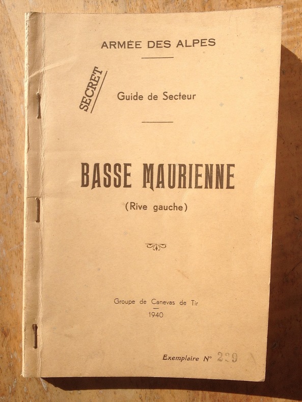
71ème B.A.F / 99ème R.I.A / Groupe de Canevas de Tir.
ARMEE DES ALPES / Guide de Secteur BASSE MAURIENNE ( Rive gauche ). ( Secret )
1940 1940 Edité par le Groupe de Canevas de Tir de l'Armée des Alpes. 1940. un guide de format in 8 de 144 pages avec une carte repliée. description de 56 passages ou cols des alpes de la Basse Maurienne. Exemplaire N° 229. Broché et agrafé. Nota: cette nouvelle édition présente quelques modifications, en regard de celle de 1939, dont la suppression des croquis et leur remplacement par une carte au 1/50.000 type 1922. tamponné " SECRET ". Rare. ref. col de la Croix-de-Fer, col de Fréjus, col de Fontaine Froide, col de Névache, col des Rochilles, passage du Pic du Thabor, etc.......
書籍販売業者の参照番号
: 2545
|
|
|
[ Barbieri, Giuseppe - Vergnano, Letizia ]
Commento al foglio primo, I. - Barbieri, G., La Venezia tridentina nella carta di Giovanni Antonio Magini. II. - Vergnano, L., Saggio di bibliografia cartografica nella regione tridentina.
cm. 17 x 24, 90 pp. con 2 tavv. f.t. Atlante Toponomastico della Venezia Tridentina 167 gr. 90 p.
|
|
|
[AFRIQUE].-
Carte Ecclésiastique de l'Afrique au 1/12000000e par le R. P. Meillorat de la Congrégation du St Esprit et du Sacré Coeur de Marie.-
Supplément du Journal des Missions Catholiques. Paris. Imp. Lemercier. 1892. Grande feuille de ca 740 x 900 mm, pliée en 16, carte de ca 690 x 720 mm. Carte de l'Evêché de San Iago dans un tout petit cartouche (120 x 50 mm). A gauche de la carte, tableau des Archevêchés, Evêchés, Vicariats et Préfectures Apostoliques, au dessus de ce tableau Etat du Catholicisme en Afrique d'après l'ouvrage Orbis Terrarum Catholicus de R.P. Werner S. J. Réparations au dos aux croisements des pliures mais bon exemplaire, tiré en noir et souligné de rouge et d'orangé.
書籍販売業者の参照番号
: ORD-14350
|
|
|
[AFRIQUE].-
Nouvelle carte de l'Afrique.-
Echelle 1/8 000 000°, format 110 x 120cm. Tirage en 6 couleurs. Taride. s.d. Grande carte dressée par PELTIER, plusieurs fois repliée (mal) dans sa couverture d'origine (salie et un peu déchirée). Petites déchirures aux coins de pliage sans manques.
書籍販売業者の参照番号
: ORD-59
|
|
|
[AGEN].
Carte d'Etat Major
au 1/80000 levée par les Officiers du Corps d'Etat-Major et publiée par le Dépôt de la Guerre en 1859. Imp.Lemercier. Gde carte en 4 pièces collées sur toile (580x845mm)
書籍販売業者の参照番号
: ORD-73
|
|
|
[AHMET] MUHITTIN [ERGÜVEN], (1883-1969); MIRLIVA ALI SEREF PASHA, (Author and mapmaker of 'Umûmî Cografya Atlasi' published in 1894 - Active between 1885-1905).
[EARLY OTTOMAN MAP OF SUDAN] Sudan. Sâye-i Türkiye Hazret Gazi Sultan Abdülhamid Hân-i Sâni'de Maarif Umûmiye Nezâret-i Celîlesi ruhsatiyle meshur Haset tarafindan Fransa Cemiyet-i Cografya âzâlarindan mütesekkil komisyona mahsûs tanzîm edilmis oldugu son defaki atlasinin tercümesi olarak bu def'a Erkân-i Umûmiyye Dairesi Besinci Fen Subesi'ne me'mûr piyade mirlivâlarindan saâdetlü Ali Seref Pasa ve rifatlu binbasi fütûvvetlü Muhyiddin Efendi maarifetleriyle tertib ettirilmistir.
Very Good Turkish, Ottoman (1500-1928) Original color lithograph map. Folded. Oblong folio. (35 x 52 cm). In Ottoman script (Old Turkish with Arabic letters). It shows Sudan and West Africa, Atlas Ocean shores, Sahra Desert, and other parts of Africa. Scale: 1:15.000.000. A very detailed and attractive map. Slightly fading. Otherwise a very good copy. Dated Hegira: 1310 = [Gregorian 1894]. Taken from his attractive atlas titled "Yeni cografya atlasi. [i.e. New Geographical Atlas]". The cartographer, Ali Seref, or Hafiz Ali Seref (or Esref) Pasha (1840-1907) was an Ottoman soldier and mapmaker who was schooled in Paris as a cartographer around 1862. While in Paris he published his first atlas with 22 maps, called the Yeni atlas. Upon his return to Istanbul, he became the chief cartographer at the Matbaa-i Amire Printing Press in Beyazit. Chipping on extremities. Slight foxing. Overall a good copy. Not in OCLC.; Not in TBMM Map Collection.
|
|
|
[AHMET] MUHITTIN [ERGÜVEN], (1883-1969); MIRLIVA ALI SEREF PASHA, (Author and mapmaker of 'Umûmî Cografya Atlasi' published in 1894 - Active between 1885-1905).
[OTTOMAN MAP of BRITISH ISLES] Ingiltere. Sâye-i Türkiye Hazret Gazi Sultan Abdülhamid Hân-i Sâni'de Maarif Umûmiye Nezâret-i Celîlesi ruhsatiyle Haset tarafindan Fransa Cemiyet-i Cografya âzâlarindan mütesekkil komisyona mahsûs tanzîm edilmis oldugu son atlasinin tercümesi olarak bu def'a Erkân-i Umûmiyye Dairesi Besinci Fen Subesi'ne me'mûr piyade mirlivâlarindan saâdetlü Ali Seref Pasa ve topçu yüzbasilarindan fütûvvetlü Mehmed Nis'et Efendi maarifetleriyle tertib ettirilmistir.
Very Good Turkish, Ottoman (1500-1928) Original color map. Folded. Oblong folio. (35 x 52 cm). In Ottoman script. Color lithograph. It shows Sudan and West Africa, Atlas Ocean shores, Sahra Desert, and other parts of Africa. Scale: 1:15.000.000. A very detailed and attractive map. Slightly fading. Otherwise a very good copy. Dated Hegira: 1310 = [Gregorian 1894]. [EARLY OTTOMAN MAP of SUDAN] Sudan. Sâye-i Türkiye Hazret Gazi Sultan Abdülhamid Hân-i Sâni'de Maarif Umûmiye Nezâret-i Celîlesi ruhsatiyle meshur Haset tarafindan Fransa Cemiyet-i Cografya âzâlarindan mütesekkil komisyona mahsûs tanzîm edilmis oldugu son defaki atlasinin tercümesi olarak bu def'a Erkân-i Umûmiyye Dairesi Besinci Fen Subesi'ne me'mûr piyade mirlivâlarindan saâdetlü Ali Seref Pasa ve rifatlubinbasi fütûvvetlü Muhyiddin Efendi maarifetleriyle tertib ettirilmistir. Ali Seref Pasa or Hafix Ali Esref. He was a soldier, who was schooled in Paris as a cartographer around 1862. Already in Paris he published his first atlas with 22 maps, called 'Yeni atlas'. Upon his return to Istanbul he became a chief cartographer at the Maatbaa-i amire Printing Press in Beyazit, which was the successor of the Muteferrika press from 1727. Among others he translated the large Kiepert map of Anatolia to Ottoman. He died in 1907, leaving his large project of a gigantic map of Anatolia in 100 sheets unfinished. Ali's name is often misunderstood or even listed as two different people: Ali Seref Pasa and Hafiz Ali Esref. Until the surname law adopted on June 21, 1934, Turks did not have surnames. They were born with one first name and were until the adulthood described only as sons or daughters of their parent's names. Later they were given titles such as Effendi (Sir), Bey (Chief) or Hanim (Madam) for higher classes, or they were given names according to their work or class. The names were not inherited by children until 1934, when the surname law was enforced. The map maker Ali received names Seref, the honourable, and Pasa, the dignitary. He was also known as Hafiz, the memorizer of Qur'an and Esref, Proud. So Ali Seref Pasa would have a meaning 'Honourable Dignitary Ali, and Hafiz Ali Esref, Memorizer of Qur'an, Proud Ali. Daruttibaa - Matbaa-I Amire Printing Press: The first press in the Muslim world, called Daruttibaa, was founded in Istanbul by Ibrahim Muteferrika in 1727, with a permission of Sultan Ahmeet III. It was located in Muteferrika's house. The first book was published in 1729 and until 1742 sixteen other works followed. After Muteferrika's death, the press was supressed for printing, as printed books were considered dangerous. In 1796 the press was purchased by the government and moved to Uskudar in Istanbul, and in 1831 finally to Beyazit, where it was renamed to Matbaa-i Amire in 1866. The press was closed in 1901 and was reopened in 1908 under the name 'Âmire' In 1927 the name changed to State Printing House. The press still exists and is known for publishing school and educational books. Extremely rare. Not in OCLC.; Not in TBMM Map Collection.
|
|
|
[AMSTERDAM. ROTTERDAM].-
Plan des Ports d'Amsterdam et de Rotterdam. 1886.-
Tiré de l'Atlas des Ports étrangers. Paris. Imprimerie Nationale. 1886. Grand plan de 54 x 33 cm plié en 3 volets, gravé par A. Simon, publié par le Ministère des Travaux Publics. Impression en noir et bleu. Bords de feuille lgt poussiéreux sinon bon état.
書籍販売業者の参照番号
: ORD-16540
|
|
|
[Anonimo]
Survey of Israel. MAP OF TEL-AVIV. Scale 1:10.000.
Carta topografica di Tel Aviv alla scala 1:10.000, cm 77x86, a colori, entro due faccette in brossura cm 21x13. In copertina datata 1949, ma con indicazione Compiled, printed and drawn by The Survey of Israel, Ministry of Labour and Social Security, January 1950. Revised from Air Photos (Air Force) dated 1949.

|
|
|
[ANONYMOUS].
[EGYPT, HABESH [ETHIOPIA], SUDAN AND THE RED SEA] Manuscript map on a tissue paper of Egypt, Ethiopia, Sudan, Red Sea, circa 1890.
Very Good Arabic Original hand-colored map on tissue paper. 23x19 cm. In Ottoman script and Arabic. No scale. Manuscript notes of toponyms. The manuscript shows Egypt, Ethiopia, Sudan, the Red Sea along the line of Red Sea shores. Manuscript notes show that the map was used for military purposes in the last Ottoman Imperial period. Habesh Eyalet, Ethiopia in northeast Africa was conquered by Özdemir Pasha in 1557. His son, Osman Pasha, transformed the region into an eyalet, which remained under Ottoman suzerainty until the early 19th century when Egypt assumed its administration. (Source: Pashas, Begs, Effendis: A historical dictionary of titles and terms in the Ottoman Empire, Bayerle, Gustav.).
|
|
|
[ANONYMOUS].
[Manuscript map of Alexandria Port and its immediate hinterland].
Very Good Turkish Original manuscript map of Alexandria Port and its immediate hinterland. Folio. (33 x 41 cm). In Turkish (Modern). Folded. No scale. The manuscript shows Alexandria Port and the Palace of the King Farouk of Egypt, customs shores, ports and harbors, locations of the British ships, radio station, location of SS Ramlah, strait, Great Pass (?), waterfront for the lumber ships, sea current zones and probably entrance and exit routes etc. A very detailed map, decorated with ships. Some repairs with tape, tears, foxing and stains. Overall a good copy.
|
|
|
[ANVERS]
PLAN MONUMENTAL DE LA VILLE D"ANVERS (Guide et indicateur "BRABO")
in-16°, non pagine (42 pages), carte depliante en couleurs + pubs, cartonnage illustre. Bon etat (traces de mouillures aux pages de texte et aux plats). [BU-1]
|
|
|
[ANVERS] Institut Cartographique Militaire
Carte de Belgique au 100.000e : II. ANVERS.
Bruxelles, Imprimerie litho de l'Institut Cartographique Militaire, 1933. Carte dépliante lithographique en couleurs (85 x 67 cm)
書籍販売業者の参照番号
: 77828
|
|
|
[ANVERS] Institut Cartographique Militaire
Carte de Belgique au 100.000e : II. ANVERS.
Carte dépliante lithographique en couleurs (85 x 67 cm) Bon état. [ARCH]
|
|
|
[ARLES et CAMARGUE].-
Carte d'Etat Major.-
Révisée en 1906, tirage de 1925. Grande carte (635 x 397 mm) hors marge, dimensions complètes (750 x 540 mm) en noir et blanc, montrant le delta du Rhône au nord de l'étang de Vaccarès. Limites à titre indicatif: à l'ouest le Mas Rabot, à l'est le Marais des Chanoines, au nord le Mas d'Assouan, au sud Silvéréal. Bords de marges un peu abîmées sinon bon état.
書籍販売業者の参照番号
: ORD-11699
|
|
|
[ARLON] Institut Cartographique Militaire
Carte de Belgique au 100.000e : XI. ARLON.
Bruxelles, Imprimerie litho de l'Institut Cartographique Militaire, 1933. Carte dépliante lithographique en couleurs (85 x 67 cm)
書籍販売業者の参照番号
: 77824
|
|
|
[ARLON] Institut Cartographique Militaire
Carte de Belgique au 100.000e : XI. ARLON.
Carte dépliante lithographique en couleurs (85 x 67 cm) Très bon état. [ARCH]
|
|
|
[ATLAS MIGEON]
La France et ses Colonies. Atlas illustré. Cent huit cartes... par Vuillemin, Thuillier, Lacoste sous la direction de J. Migeon. Texte rédigé par A. Martineau et H. Stein.
Paris, J. Migeon, 1886. In-folio, demi-chagrin noir, dos à nerfs orné avec titre doré. 108 cartes en couleurs des départements français et des colonies (y compris le planisphère des colonies françaises). Plats et coupes frottés, coins émoussés.
書籍販売業者の参照番号
: 4363
|
|
|
[AUVERGNE].
Carte officielle du Service Géographique de l'Armée 1/200.000.-
France Tourisme. EPOC. Tirage de Juillet 1929. Très grande carte couleurs de 972 x 648 mm repliée en 18 volets de 162 x 216 mm. Publicités et légendes au dos de la carte. Carte sous étui imprimé et un peu insolé. Petite fente sans perte à un pli sinon bon exemplaire.
書籍販売業者の参照番号
: ORD-16399
|
|
|
[BARROW].-
Plan du Port de Barrow 1884.-
Tiré de l'Atlas des Ports étrangers. Paris. Imprimerie Nationale. 1886. Grand plan de 64,5 x 33 cm plié en 3 volets, gravé par A. Simon, publié par le Ministère des Travaux Publics. Impression en noir et bleu. Bords de feuille lgt poussiéreux sinon bon état.
書籍販売業者の参照番号
: ORD-16560
|
|
|
[BES & DUBREUIL].-
La France routière et ses colonies. 1871.-
Carte indiquant les routes nationales et départementales, les chemins de fer, les fleuves, rivières et canaux, les itinéraires des paquebots à vapeur et les phares, l'histoire et la statistique des colonies, dessinée par Charles, revue par Vuillemin. Publiée à Paris par Bès & Dubreuil. (1871). Grande carte dépliante couleurs (600 x 890mm) sous cartonnage in-12 (101 x 158mm) rouge, étiquette de titre, lettres dorées sur le 1°plat. Cartonnage assez usé, 2 petits trous sans perte à des angles de plis sinon bon exemplaire.
書籍販売業者の参照番号
: ORD-1102
|
|
|
[BONNE Rigobert], [CARTE ANCIENNE]
Guinée IIe feuille
Carte (42 x 31,5 cm hors marges) des côtes du golfe de Guinée (c. 1780) gravée sur cuivre. Frontières, côtes et encadrement réhaussés. Dimensions totales : 510 mm x 360 mm. Dimensions hors marges : 420 mm x 315 mm.Bel état. Papier légèrement jauni,quelques très légères rousseurs au dos et menus défauts.Tirage de l'époque.Rare.
書籍販売業者の参照番号
: 4773
|
|
|
[BORDEAUX].-
Plan du Port de Bordeaux 1886.-
Tiré de l'Atlas des Ports étrangers. Paris. Imprimerie Nationale. 1886. Grand plan de 63 x 33 cm plié en 3 volets, gravé par A. Simon, publié par le Ministère des Travaux Publics. Impression en noir et bleu. Bande de 32mm insolée sur le bord gauche de la feuille sinon bon état.
書籍販売業者の参照番号
: ORD-16596
|
|
|
[BOSTON].-
New Map of Boston with squares and numbers after the Baedeker plan, copyright 1880 by M. F. Sweetser.-
Boston. Sweetser. 1880. Grand plan de ca 684 X 500 mm, replié au format in-12 (ca 127 x 172 mm) et placé dans un pochette portant au recto une publicité illustrée pour Rever House et au verso pour Stoning Line et Shore Line. Pochette un peu tachée et poussiéreuse, plan et pochette perc&s de trous d'aiguille minuscules, à peine visibles lorsque le plan est déployé.
書籍販売業者の参照番号
: ORD-15099
|
|
|
[BOULOGNE].-
Plan du Port de Boulogne 1884.-
Tiré de l'Atlas des Ports étrangers. Paris. Imprimerie Nationale. 1886. Grand plan de 68 x 33 cm plié en 3 volets, gravé par A. Simon, publié par le Ministère des Travaux Publics. Impression en noir et bleu. Bords de feuille lgt poussiéreux sinon bon état.
書籍販売業者の参照番号
: ORD-16598
|
|
|
[BRETAGNE].-
La Bretagne. Plan touristique et monumental.-
Paris. Arts Photomécaniques. S.d. Très grand plan de 645 x 990mm très coloré, signé Jean Flornay ou Flornoy, plusieurs fois replié sous couverture illustrée couleurs (105 x 170mm). Menus défauts mais carte très décorative.
書籍販売業者の参照番号
: ORD-1539
|
|
|
[BRUGES] Institut Cartographique Militaire
Carte de Belgique au 100.000e : I. BRUGES.
Bruxelles, Imprimerie litho de l'Institut Cartographique Militaire, 1933. Carte dépliante lithographique en couleurs (85 x 67 cm)
書籍販売業者の参照番号
: 77829
|
|
|
[BRUGES] Institut Cartographique Militaire
Carte de Belgique au 100.000e : I. BRUGES.
Carte dépliante lithographique en couleurs (85 x 67 cm) Bon état. [ARCH]
|
|
|
[BRUXELLES] EXPOSITION UNIVERSELLE
Bruxelles : Souvenir de l'Exposition de 1897.- Plans comparatifs de Bruxelles 1830- 1897.
Bruxelles, Syndicat Commercial des Exposants Etrangers, 1897. Plan polychrome de Bruxelles en 1830 et en 1897 (date de l'Exposition universelle), avec de belles annonces publicitaires. (mesures : 100cm x 70 cm).
書籍販売業者の参照番号
: 77798
|
|
|
[BRUXELLES] EXPOSITION UNIVERSELLE
Bruxelles : Souvenir de l'Exposition de 1897.- Plans comparatifs de Bruxelles 1830- 1897.
Plan polychrome de Bruxelles en 1830 et en 1897 (date de l'Exposition universelle), avec de belles annonces publicitaires. (mesures : 100cm x 70 cm). Bon etat (petites à l'endroit des plis). [ARCH]
|
|
|
[BRUXELLES] Institut Cartographique Militaire
Carte de Belgique au 100.000e : V. BRUXELLES.
Bruxelles, Imprimerie litho de l'Institut Cartographique Militaire, 1933. Carte dépliante lithographique en couleurs (85 x 67 cm)
書籍販売業者の参照番号
: 77825
|
|
|
[BRUXELLES] Institut Cartographique Militaire
Carte de Belgique au 100.000e : V. BRUXELLES.
Carte dépliante lithographique en couleurs (85 x 67 cm) Très bon état. [ARCH]
|
|
|
[BRUXELLES] TRAMWAYS
"Les Tramways Bruxellois".- Exposition 1935.- Plan du réseau des Tramways Bruxellois édité à l'occasion de l'Exposition universelle de 1935.
Exemplaire complet avec la carte mobile du réseau, le plan de l'Exposition, les tarifs et l'index des rues et des lignes.- Format : fermé 13 x 24cm / ouvert 51 cm, illustrée. Tres bon etat. [ARCH]
|
|
|
[CALAIS].-
Plan du Port de Calais 1886.-
Tiré de l'Atlas des Ports étrangers. Paris. Imprimerie Nationale. 1886. Grand plan de 49 x 33 cm plié en 2 volets, gravé par A. Simon, publié par le Ministère des Travaux Publics. Impression en noir et bleu. Bon état.
書籍販売業者の参照番号
: ORD-16606
|
|
|
[CARTE ANCIENNE PERSE] [PERSIA, PERSIAN GULF BAHRAIN OLD MAP]
A New Map of the Empire of Persia from Monsieur d'Anville First Geographer to the most Christian King ; with several Additions and Emendations
1794 London, Laurie & Whittle, 1794 Carte gravée sur cuivre (50,5 x 57 cm hors marges, 54 x 73 cm toutes marges comprises). Tirage de l'époque. Quelques traces d'une autre carte en surimpression. Map on copperplate (50,5 x 57 cm without the margins, 54 x 73 cm with the margins). Contemporary printing. Several light printed marks of another map.
書籍販売業者の参照番号
: 4619
|
|
 検索結果のメールを受信する
 PDFファイルの検索結果をダウンロード
 RSSフィード


