|
Service HYDROGRAPHIQUE de la Marine
De PORTO-VECCHIO au CAP PERTUSATO, Bouches de Bonifacio. [CARTA NAUTICA] Echelle 1:35.680. Con le isole CERBICALE, LAVEZZI, CAVALLO, Razzoli, La Presa ecc.
Carta nautica di cm. 105,2x74 su forte carta, ripiegata. Include le isole CERBICALE, LAVEZZI, CAVALLO, Razzoli, La Presa ecc. Carte levée en 1884 et 1890, 1894, sondes en mètres. Tracce di gualcitura e di polvere, ma integra e robusta. Gravé: le trait par Francoz, la topographie par DELAUNE, la lettre par Er. Dumas Vorzet.
|
|
|
Sestini Aldo
L'opera scientifica del socio straniero Carl Troll
|
|
|
SESTINI ALDO
La lettura delle carte geografiche (Con cenni sugli esercizi cartografici e sulla storia della cartografia)
16° bross. edit. pp. 156, (8 di tabelle) Con 78 figure nt. e 2 tavole f.t. "Manualetti". Poche sottolin. a lapis.

|
|
|
Sestini, Aldo
La Lettura delle Carte Geografiche Con Cenni Sugli Esercizi Czrtografici e Sulla Storia Della Cartografia
Mm 130x190 Brossura editoriale di pagine 162 (8) con illustrazioni in nero nel testo e due tavole fuori testo di cui una a colori, diffuse sottolineature a matita, fioriture ai piatti. Spedizione in 24 ore dalla conferma dell'ordine.

|
|
|
Sestini,Aldo. Nice,Bruno. Mori,Alberto ed altri.
L'Italia fisica.
<br/> STATO: USATO, MOLTO BUONO.<br/> TITOLO: L'Italia fisica. <br/> AUTORE: Sestini,Aldo. Nice,Bruno. Mori,Alberto ed altri.<br/> EDITORE: Touring Club Italiano<br/> DATA ED.: 1957,<br/> COLLANA: Coll.Conosci l'Italia,1.<br/>
|
|
|
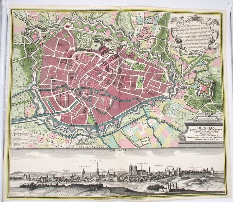
SEUTTER (Matthäus)
Bruxeliae Belgii Cathol. Ornamentum et Ducatus Brabantiae Metropolis accuratissima aeri incia a Matthaeo Seuttero (Bruxelles, Brussel).
Augsburg (Allemagne), Seutter Matthäus, circa 1740. 59 x 51 cm (pliure centrale, déchirure restaurée au bas de la planche).
書籍販売業者の参照番号
: 15866
|
|
|
SEUTTER MATTEUS
Insula et Regnum Sardiniae
Augsburg 1730 Incisione originale su rame, mm 500 x 580 e margini, abilmente colorata da mano coeva. Bella e raffinata carta geografica della Sardegna tratta dall'Atlas Novus del Seutter pubblicato ad Augsburg nel 1730 ca. In alto a sinistra il titolo entro importante cartiglio animato da personaggi, flora e fauna di carattere allegorico. In basso altri due cartigli con le scale metriche e lo stemma di Vittorio Amedeo II di Savoia, nel quale è inserito anche lo stemma sardo. La mappa è basata sulla medesima rappresentazione dell'isola disegnata dal Coronelli nel 1680.
書籍販売業者の参照番号
: 21072
|
|
|
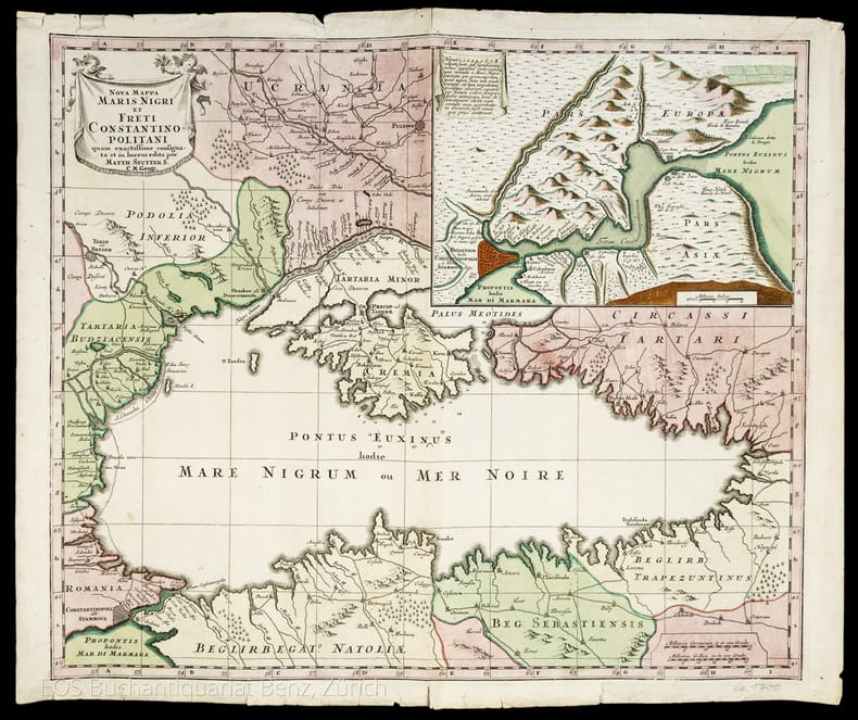
Seutter, Matthias (1678–1757):
Nova Mappa Maris Nigri et Freti Constantinopolitani.
Augsburg, 1741. Altkolorierter Kupferstich. Blattgrösse: 49.4 x 57.8 cm
書籍販売業者の参照番号
: 986DG
|
|
|
SEUTTER MATTHAUS
DUCATUS CARNIOLAE VINDORUM MARCHIA ET HISTRIA
SEUTTER MATTHAUS DUCATUS CARNIOLAE VINDORUM MARCHIA ET HISTRIA. , 1730, La carta è uno dei rifaciamenti della tavola "Tabula Ducatus Carniola, Vindorum Marchiae et Histriae" di Johann Baptiste Homann realizzata dopo il 1716. Buono (Good) Buon es. - piccoli strappi nel margine superiore. acquaforte acquerellata in epoca <br> cm. 58 x 49.5 <br> <br> <br>

|
|
|
Seutter Matthaus
Quattro continenti: Europa, Africa, Asia, Novus Orbis sive America
Proveniente da : "Atlas novus sive tabulae geographicae totius orbis faciem, partes, imperia, regna et provincias exhibentes, exactissima cura juxta recentissimas observation. aeri incisae et venum expositae a Matthaeo Seutter chalcogr". Prima edizione.

|
|
|
SEUTTER MATTHAUS.
Dominium Venetum cum adjacentibus Mediolan. Mant. Mutinensi, Mirandol., Parmen., Placent. Ducat.
Carta di mm 198x260, ripiegata tre volte e inserita in busta editoriale (mm 108x73) con unghiatura e bel cartiglio allegorico che ne ripete il titolo. La carta geografica, conforme a quella impressa nell’Atlas minor (Augsburg, Lotter, 1750), reca nell’angolo superiore sinistro, su cartiglio allegorico, il titolo, e nell’inferiore destro le scale geografiche; stampata su carta forte e finemente acquerellata a più colori da mano coeva; stato di conservazione molto buono LIB - (B - V)
|
|
|
SEUTTER MATTHAUS.
Ducatus Sabaudiae Princip. cum adjacentibus Mediolan. Mant. Mutinensi, Mirandol., Parmen., Placent. Ducat.
Carta di mm 199x262, ripiegata tre volte e inserita in busta editoriale (mm 108x73) con unghiatura e bel cartiglio allegorico che ne ripete il titolo. La carta geografica, conforme a quella impressa nell’Atlas minor (Augsburg, Lotter, 1750), reca nell’angolo superiore destro, su cartiglio allegorico, il titolo, e nell’inferiore destro le scale geografiche; stampata su carta forte e finemente acquerellata a più colori da mano coeva, è in ottimo stato di conservazione LIB - (B - V)
|
|
|
SEUTTER, GEORG. MATTHAUS (SEUTTER, MATTH.).
Reipublicae Genuensis Dominium.
Augusta, 1740 circa. Incisione in rame, colore d’epoca, cm 50 x 58 (alla lastra). Se le carte del Seutter in molto assomigliano a quelle dell’Homann, tanto da non essere talvolta subito distinguibili, ciò che maggiormente le differenzia riguarda il cartiglio, spesso enormemente accresciuto con figure che si rifanno al mito, piuttosto che a qualche potente cui sia dedicata la stampa. Inoltre, non di rado, nella parte inferiore dl foglio, trovano spazio degli scorci di città, cosa che costituisce una su caratteristica peculiare rispetto ad altri editori, anche del passato. Esemplare con un’impressione un po’ stanca e un leggero foxing al margine bianco, nell’insieme discreto stato.

|
|
|
SEUTTER, GEORG. MATTHAUS (SEUTTER, MATTH.).
Republicae Genuensis Dominium.
Augusta, 1740 ca. Incisione in rame, colore d’epoca, cm 50 x 58 (alla lastra). Se le carte del Seutter in molto assomigliano a quelle dell’Homann, tanto da non essere talvolta subito distinguibili, ciò che maggiormente le differenzia riguarda il cartiglio, spesso enormemente accresciuto con figure che si rifanno al mito, piuttosto che a qualche potente cui sia dedicata la stampa. Inoltre, non di rado, nella parte inferiore dl foglio, trovano spazio degli scorci di città, cosa che costituisce una su caratteristica peculiare rispetto ad altri editori, anche del passato. Bell’esemplare, in margini, in bella coloritura e in bella impressione.

|
|
|
SEUTTER, GEORG. MATTHAUS (SEUTTERI, MATTHAEI).
Principali dignitate gaudens comitat. Tirolis Episcopat. Tridentinum et Brixiensem.
Augusta, 1740 circa. Tratta dall “Atlas novus indicibus instructus”, incisione in rame, colore d’epoca, cm 50 x 58 (alla lastra). Carta raffigurante il territorio tirolese, l'impostazione è molto simile alla carta di J.B. Homann edita nel 1716. Anche le decorazioni che accompagnano il titolo ricordano quella dell' Homann, con la fortezza di Covelo sullo sfondo e diverse figure allegoriche nel primo piano. (Bibl. “Il territorio trentino - tirolese nell’antica cartografia” di Gino Tomasi, scheda n. 56). Ingiallimento della brachetta centrale, peraltro a pieni margini e in buono stato di conservazione.

|
|
|
SEUTTER, GEORGE MATTHAUS IL VECCHIO.
Neapolis Regnum quo continentur Aprutium Ulterius et Citer.
Augsburg, 1730 circa. Tratta da "Atlas Minor", 1750 circa. Incisione in rame all'acquaforte, coloritura coeva, cm 21 x 27,2 (alla lastra). Carta geografica della parte meridionale della penisola, con bel cartiglio decorato nella parte superiore, vascelli in mare e piccola scenetta col crateri fumanti in basso a destra. Bella la coloritura, buono lo stato di conservazione.

|
|
|
SEUTTER, MATTHEO – LOTTER, CONRAD - KAEMPFERO, ENGELBERTO.
Regni Japoniae. Nova mappa geographica, ex indigenarum observationibus delineata.
Augusta Vindelicrum, Norimberga, 1730 circa. Da "Atlas Novus", edito tra il 1728 e il 1730. Incisione in rame all'acquaforte, coeva coloritura a mano, cm 50 x 59 circa (il foglio) più margini. Grande e ricco cartiglio in alto a sinistra, con figure di studiosi orientali, una rosa dei venti al centro, in basso alcuni schemi riportano simboli della cultura e della civiltà giapponese, margine graduato su tutto il perimetro. Esemplare in tenue coloritura, sparse e piccole fioriture, due piccoli strappi al margine inferiore, in margini e in buono stato di conservazione. .

|
|
|
SEUTTER, MATTHEUS (SEUTTERO, MATTEO).
Gli Stati del Sommo Pontefice chiamati il Patrimonio di San Pietro con insieme il Latio Vecchio et Campagna di Sabina. Carta Geografica esattamente delineata.
Augusta, 1740 circa. Incisione in rame all’acquaforte, colore d’epoca, cm 48,5 x 56,5 (la parte figurata) 49,5 x 58,5 (alla lastra) più margini bianchi. Delineata dal Seutter (il nome nel cartiglio) e incisa dal Tob. Conr. Lotter (il nome n lastra in basso a destra), splendida mappa della zona di Roma, con le regioni circostanti chiaramente delineate e indicate. Magnifico il cartiglio con titolo e Autore circondato da decori, e, in un paesaggio boschivo, una tenda regale che contiene una corona d'oro custodita da cherubini. Esistono della stampa due diverse versioni, con due diversi cartigli, questa la meno comune e con il cartiglio più bello. Leggermente rifilato il margine superiore bianco, peraltro in bella impressione e in bellissima coloritura, molto buono lo stato di conservazione.

|
|
|
SEUTTER, MATTHEUS.
Cursus Padi per Longobardiam a Fonte usque a ostia cum fluminibus que in illum se exonerant et adjacentibus Ducatibus ac Principatibus quos interluit et qui confinis sunt, Tribus Combinandis tabellis.
Augusta, 1740 circa. Incisione in rame all’acquaforte, incisa su tre fogli, colore d’epoca, cm 58,5 x 133,5 (alla lastra). Cartouche in alto al centro, circondata da figure allegoriche e con gli stemmi della Savoia, Piemonte, Monferrato, Milano, Parma, Modena, Mantova, Ferrara, Bologna e Venezia; cartiglio altrettanto riccamente decorato e allegorizzato in basso a sinistra. Opera tra le più importanti di Matthaeus Seutter, questa carta rappresenta la descrizione geografica del corso del fiume Po, con i territori interessati e quelli adiacenti, dalle sorgenti alla foce, comprendendo praticamente tutta l’Italia del Nord, con la designazione dei vari Ducati, Repubbliche e Legazioni. Matthaus Seutter (1678 -1756), dopo un apprendistato presso gli Homann a Norimberga, si trasferì ad Augsburg verso il 1720, e qui aprì la propria attività superando il maestro sotto il profilo della bellezza: le sue carte hanno sempre colori brillanti e cartigli elaborati. Minimamente rifilato il margine laterale sinistro in prossimità della battuta, stretti i margini sugli altri lati ma trattasi di ottimo esemplare in bella coloritura e in magnifico stato di conservazione.

|
|
|
SEUTTER, MATTHEUS.
Ducatus Mantuani quam castigatissima delineatio.
Augusta, 1730 circa. Incisione in rame all’acquaforte, colore d’epoca, cm 50,5 x 58,5 (alla lastra) più stretti margini, ricco cartiglio con figure in alto a sinistra. Una piccola mancanza dell’inciso su una delle figure al cartiglio, èperaltro in bella coloritura e in ottimo stato di conservazione.

|
|
|
Seutter, Matthias (1678?1757)
Nova Mappa Maris Nigri et Freti Constantinopolitani.
Augsburg, 1741. Altkolorierter Kupferstich. Blattgrösse: 49.4 x 57.8 cm + Wichtig: Für unsere Kunden in der EU erfolgt der Versand alle 14 Tage verzollt ab Deutschland / Postbank-Konto in Deutschland vorhanden +, 986DG
書籍販売業者の参照番号
: 986DG

|
|
|
Seutter, Matthäus
Mappa Geographica in qua Ducatus Lotharingiae et Barr ut et Episcopatuum Metens. Tullens. Verdunens. [Um 1730]. [altkolorierter Kupferstich, gerahmt / handcolored copper engraving, framed].
o.J. Matthäus Seutter (Matthias Seutter), geboren 1678 in Augsburg; gestorben 1757 ebenda. [3 Warenabbildungen]
書籍販売業者の参照番号
: 59009BB

|
|
|
Seutter, Matthäus
Peloponnesus Hodie Morea. [Um 1730]. [altkolorierter Kupferstich, gerahmt / handcolored copper engraving, framed].
o.J. Matthäus Seutter (Matthias Seutter), geboren 1678 in Augsburg; gestorben 1757 ebenda. [3 Warenabbildungen]
書籍販売業者の参照番号
: 59008BB

|
|
|
Seutter, Matthäus
XVII. Provinciae Belgii sive Germaniae Inferioris priscis temporib...[Um 1730]. [altkolorierter Kupferstich, gerahmt / handcolored copper engraving, framed].
o.J. Matthäus Seutter (Matthias Seutter), geboren 1678 in Augsburg; gestorben 1757 ebenda. [3 Warenabbildungen]
書籍販売業者の参照番号
: 59007BB

|
|
|
SEYMOUR H. / ROSE William and Fanny.
A TOUR to GREAT ST BERNARD'S and round MONT BLANC. with Descriptions copied from a Journal kept by the Author; and drawings taken from Nature. intended for young persons from ten to fourteen Years of Age.
1827 1827 London. printed for Harvey and Darton, Gracechurch - street. 1827 . Un volume petit in 8. percaline éditeur bleue en trés bon état , les coins et plats en parfait état , dos légèrement insolé comme souvent. toutes tranches dorées. Ex libris sur pages de gardes. carte repliée en regard de la page de titre. " A Map of the country round Great St Bernard and Mount Blanc with the route of the Tourists ". Titre + iv pp + 144 pp. avec 8 Planches hors texte comprenant chacune 2 illustrations. Soit 16 jolies gravures sur acier textées. EDITION ORIGINALE. COMPLET.BEL EXEMPLAIRE en très bon état intérieur et extérieur et en cartonnage éditeur époque.
書籍販売業者の参照番号
: 2678
|
|
|
SHERRER C.
Niederlande - Belgien und Luxembourg. Carte N° 40, extraite de Stielers Hand-Atlas.
- Carte 40 x 50 cm, pliée en 2.
書籍販売業者の参照番号
: 70145
|
|
|
SHERRER C. - HABENICHT H.
Ostalpen. (Alpenländer : Westlisches Blatt.) Carte N° 15, extraite de Stielers Hand-Atlas.
- Carte 40 x 50 cm, pliée en 2.
書籍販売業者の参照番号
: 70139
|
|
|
SHERRER C. - HABENICHT H.
Schweiz. (Alpenländer : Westlisches Blatt) Carte N° 14, extraite de Stielers Hand-Atlas.
- Carte 40 x 50 cm, pliée en 2.
書籍販売業者の参照番号
: 70138
|
|
|
SHERRER C. - KOFFMAHN O.
Thüringishe Staaten. Carte N° 13, extraite de Stielers Hand-Atlas.
- Carte 40 x 50 cm, pliée en 2.
書籍販売業者の参照番号
: 70137
|
|
|
Shirley Rodney W
Early Printed Maps of the British Isles : A Bibliography 1477-1650 Revised Edition
London: Holland Press 1980. Brand New in perfect condition. NO rubbing. NO fading. Bright clean square and tight. Sharp corners. NO owner's name or bookplate. NO remainder mark. Fresh and crisp -- obviously never read. Revised Edition. 1980. 88 plates. In 1973 a preliminary version of this work appeared in 5 issues of the periodical MAP COLLECTORS' CIRCLE. For this 1980 revision an index has been added as well as 97 new or corrected entries. Described and commented on are over 700 maps of the period. A final chronological listing identifies the cartographer date of publication and gives an estimate of rarity for each map's principal edition or first state. Volume #5 in The Holland Press Cartographica series. Bound in the original gilt-stamped dark green boards. 7.5" wide by 10" tall. 1980 Revised Edition. Hardcover. New/No jacket. xxv 188pp. Great Packaging Fast Shipping. Holland Press Hardcover
書籍販売業者の参照番号
: 017928 ISBN : 0900470976 9780900470974
|
|
|
Shirley Rodney W
Early Printed Maps of the British Isles : A Bibliography 1477-1650 Revised Edition
London: Holland Press 1980. Near Fine condition. Bright clean square and tight. Sharp corners. NO owner's name or bookplate. NO remainder mark. Fresh and crisp -- probably never read. Revised Edition. 1980. 88 plates. In 1973 a preliminary version of this work appeared in 5 issues of the periodical MAP COLLECTORS' CIRCLE. For this 1980 revision an index has been added as well as 97 new or corrected entries. Described and commented on are over 700 maps of the period. A final chronological listing identifies the cartographer date of publication and gives an estimate of rarity for each map's principal edition or first state. Volume #5 in The Holland Press Cartographica series. Bound in the original gilt-stamped dark green boards. 7.5" wide by 10" tall. 1980 Revised Edition. Hardcover. Near Fine condition/No jacket. xxv 188pp. Great Packaging Fast Shipping. Holland Press Hardcover
書籍販売業者の参照番号
: 018076 ISBN : 0900470976 9780900470974
|
|
|
SHIRLEY RODNEY W
THE MAPPING OF THE WORLD EARLY PRINTED WORLD MAPS 1472 - 1700.
IN 4° gr.( cm.26 X 35 ), pp.669. LEGATURA EDITORIALE TELATA RIGIDA + SOVRACOPERTINA ILLUSTRATA A COLORI CON TITOLO. SGUARDIE FIGURATE. 440 ILLUSTRAZIONI in b/n/col. DI PLANISFERI DELLE VARIE EPOCHE. OPERA FONDAMENTALE PER LA CATALOGAZIONE DEI PLANISFERI E DEI LORO AUTORI, DAL 1472 AL 1700. NUOVA EDIZIONE AGGIORNATA.<BR>OTTIMA CONSERVAZIONE. RARO. ID, 6767

|
|
|
Shirley Rodney W.
The Mapping of the World. Early Printed World Maps 1472 - 1700. Volune nine.
Ril. in tela con sovr.ill. a col., cm 34,5x24,5, pp 669, moltissime ill. a col. e b/n.. Come nuovo. - ISBN: o946323038

|
|
|
SHIRLEY Rodney W. -
Early Printed Maps of the British Isles 1477-1650.
England, Antique Atlas Publications, 1991, 4to (cm. 30,5 x 21,5) legatura tutta tela con titoli dorati al piatto anteriore e al dorso e sovraccopertina illustrata a colori, pp. XX-233 con 160 carte nel testo.

|
|
|
Shmith et Burly
Département des Basses-Alpes
Planche de l'Atlas National Illustré. Dressé par Levasseur. Pas de couverture Très bon Paris Pelissier Vers 1850 35 x 50 cm
書籍販売業者の参照番号
: 11398
|
|
|
SIDER (Sandra) ANDREASIAN (Anita) & CODDING (Mitchell)
Maps, Charts, Globes: Five Centuries of Exploration. A New Edition of E. L. Stevenson's Portolan Charts and Catalogue of the 1992 Exhibition.
First Edition, 4to, 73 plates (some coloured), orig. cloth, d.w. Catalogue of the Society's manuscript portolan charts covering material from the fifteenth through the seventeenth century.
|
|
|
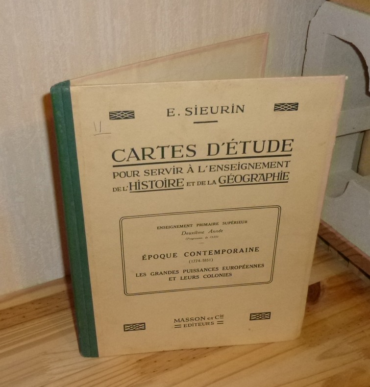
SIEURIN, E.
Cartes D'Étude pour servir à l'enseignement de l'histoire et de la géographie. Enseignement primaire supérieur deuxième année (programmes de 1920). Époque Contemporaine (1774-1851). Les grandes puissances européennes et leurs colonies. Paris, Masson et Cie. 1923.
1 volume in-4° relié toile verte, 36 cartes. Très bon état infime état d'usage.
書籍販売業者の参照番号
: 14396
|
|
|
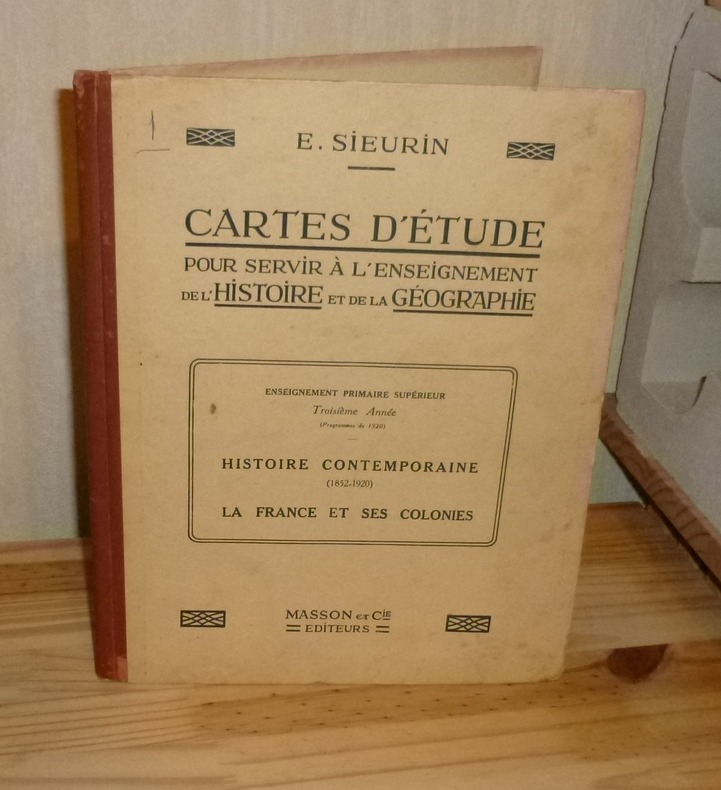
SIEURIN, E.
Cartes D'Étude pour servir à l'enseignement de l'histoire et de la géographie. Enseignement primaire supérieur troisième année (programmes de 1920). Histoire Contemporaine (1852-1920). La France et ses colonies. Paris, Masson et Cie. 1923.
1 vol. in-4° rel. toile verte, 32 cartes. Couverture un peu salie avec léger état d'usage sinon bel état.
書籍販売業者の参照番号
: 14397
|
|
|
SILVESTRE Marguerite, FINCOEUR Michel-Benoit
"Inventaire raisonné des collections cartographiques Vandermaelen, conservées à la Bibliothèque Royale de Belgique (4 volumes); tome 1 : Cartes de Belgique; tome 2 : Carte topographique de la Belgique au 1 : 20 000; tome 3 : Villes et communes de Belgique (hors Bruxelles); tome 4 : Bruxelles."
Bruxelles, Bibliothèque Royale Albert 1er, 1994-2000. 21 x 28, 4 volumes, xxviii-563 + 335 + xxx-466 + xxx-546 pages, très nombreux figures, plans et cartes en N/B et en couleurs, reliure d'édition pleine toile bleue, très bon état (1 cachet d'ex-propriétaire au bas de la page de garde dans chaque volume).
書籍販売業者の参照番号
: 91651
|
|
|
SILVESTRE M., M.B. FINCOEUR C., CHANTERENNE Bart, VANDERMAELEN
Inventaire raisonné des collections cartographiques Vandermaelen. Vols I+II+III+IV (complet!)
Bruxelles Bibliothèque Royale Albert I 1994-2000 4 Volumes = complete! Vol.I: Cartes de Belgique. Vol.II: Carte topographique de la Belgique au 1:20000. Vol. III: Villes et communes de Belgique (hors Bruxelles). Vol IV: Bruxelles. Hardcover, linnen/cloth, gold on cover and spine. In-4, xiii + 563 pp., vii + 333 pp., xxx + 466 pp., xxx + 546 pp., BW & colour illustrations. Bibliography & indexes. Text in French. Philippe Vandermaelen (1795-1869).
書籍販売業者の参照番号
: 19940057

|
|
|
SILVESTRE, M. - FINCOEUR, M.B. - CHANTERENNE, C. - OP DE BEECK, B. - ELKHADEM, H.
INVENTAIRE RAISONNE DES COLLECTIONS CARTOGRAPHIQUES VANDERMAELEN. Conservees a la Bibliotheque Royale de Belgique.- Vols I+II+III+IV+V (complet !).
Bruxelles, Bibliothèque Royale Albert I, 1994-2011. 5 volumes Hardcover in-4° (22x28 cm), + de 2500 pages, BW & colour illustrations. Bibliography & indexes. Text in French.
書籍販売業者の参照番号
: 80200
|
|
|
SILVANO GHIRONI - ANTONIO MANNO
PALMANOVA
IN 8° CARRE' ( cm.22 X 24,5 ), pp.273, COPERTINA EDITORIALE PATINATA ILLUSTRATA A COLORI CON TITOLO. 95 ILLUSTRAZIONI DI PIANTE E PARTICOLARI DELLA' CITTA' DI PALMANOVA CON RELATIVE SCHEDE. SEGUE BIBLIOGRAFIA. IL VOLUME HA IL PREGIO DI RACCOGLIERE I CONTRIBUTI DI DUE SPECIALISTI, UNO IN CARTOGRAFIA URBANA E L'ALTRO IN ARCHITETTURA MILITARE VENEZIANA SULLA STORIA DELLA CITTA' - FORTEZZA DI PALMANOVA. PERFETTA CONSERVAZIONE. ID 5023

|
|
|
SILVESTRE, M. - FINCOEUR, M.B. - CHANTERENNE, C. - OP DE BEECK, B. - ELKHADEM, H.
INVENTAIRE RAISONNE DES COLLECTIONS CARTOGRAPHIQUES VANDERMAELEN. Conservees a la Bibliotheque Royale de Belgique.- Vols I+II+III+IV+V (complet !).
5 volumes Hardcover in-4° (22x28 cm), + de 2500 pages, BW & colour illustrations. Bibliography & indexes. Text in French. Très bel ensemble, état proche du NEUF ! DEDICACE des auteurs et collaborateurs. [P-48] Vol.I: Cartes de Belgique. Vol.II: Carte topographique de la Belgique au 1:20000. Vol. III: Villes et communes de Belgique (hors Bruxelles). Vol IV: Bruxelles. Vol. V: L'Atlas universel (1825-1827)
|
|
|
Silvestri, F- Stecchi De Bellis, Maria A.- Silvestri Baffi, Rosetta- Manzionna, Rosa M.G.
LA PUGLIA NELLE ANTICHE STAMPE
In 4', br. ed. con sovrac., pp. nn., CXXX tavv. in n. molte ripiegate; opera pubblicata in occasione del XVI Congresso Nazionale dei Distretti Lions 108 Italia, copia fuori commercio numerata 401/2400, premessa di Giuseppe Pittorino, presentazione di Adriano Prandi.Segni d'uso e di sporco alla sovrac. e dorso brunito, cop. e interni in ottimo stato.

|
|
|
Silvestri, Roberto
Bastia Umbra Storia Di Terremoti estratto dalla tesi di laurea di Roberto Silvestri "Tutela del patrimonio architettonico e monumentale e rischio sismico. Il caso di Bastia" Pagine selezionate, raccolte ed integrate, da Edda Vetturini
Mm 170x240 Volume nella sua brossura originale, 144 pagine con numerose illustrazioni in nero e a colori nel testo e fuori testo, Copia in ottime condizioni. Spedizione in 24 ore dalla conferma dell'ordine.
|
|
|
SIMAAN Arkan et FONTAINE Joëlle
L'image du monde, des Babyloniens à Newton.
Paris, ADAPT Editions, 1999. 16 x 24, 235 pp., quelques illustrations en N/B, broché, très bon état (cachet d'ex-propriétaire).
書籍販売業者の参照番号
: 91895
|
|
|
SIMAR Th.
LA GEOGRAPHIE DE L'AFRIQUE CENTRALE.
Dans l'antiquit et au Moyen Age. Vromant & C., Bruxelles, 1912. In-8 gr., brossura, pp. 131,(3), con carte e figure nel testo e 9 tavole in b.n. fuori testo. Phniciens et Grecs - Les Romains - Les Arabes - Thories, cartes du XIII au XV sicle. Timbro di appartenenza al piatto anteriore, ma testo ben conservato.
書籍販売業者の参照番号
: 55197
|
|
|
SIMONE ET ROGER WAISBARD
Mirages et indiens de la selva.
1958 Julliard collection Sciences et Voyages, 1958, 292 pages + 2 cartes + 19 illustrations, in 8 broché, état moyen, insolé et jauni, couverture illustrée , usures et frottements, jaquette collée à la couverture, bords des plats abîmés, dos fatigué.
書籍販売業者の参照番号
: 14089
|
|
|
Simon Garfield
OP DE KAART hoe de wereld in kaart werd gebracht.
, Luster uitgeverij, 2014 Ingenaaid boek, 494 pp met illustraties, nieuw staat !!. ISBN 9789460581120.
書籍販売業者の参照番号
: 46500
|
|
|
SIMAR Th.
LA GEOGRAPHIE DE L’AFRIQUE CENTRALE. Dans l’antiquité et au Moyen Age.
In-8 gr., brossura, pp. 131,(3), con carte e figure nel testo e 9 tavole in b.n. fuori testo. “Phéniciens et Grecs - Les Romains - Les Arabes - Théories, cartes du XIII au XV siècle”. Timbro di appartenenza al piatto anteriore, ma testo ben conservato.
|
|
 検索結果のメールを受信する
 PDFファイルの検索結果をダウンロード
 RSSフィード


