|
Rand McNally New Indexed Atlas of the World
Map of Upper Nubia & Habesh or Abyssinia
Map colors are blue yellow light orange black and white black decorated borders. Map is 1888. All very good. Map measures 14" x 10.25". Very good condition. unknown
Bookseller reference : 001957
|
|
|
Rand McNally New Indexed Atlas of the World
Map of Utah
14" x 19.75". Map is colored in green yellow pink and coral. Locations displayed are railroad lines Uintah Indian Reservation mine locations Ute Indian Village ranches stage stations Indian R eservation agencies. This is a double page map taped in the center with archival tape and in good condition. Map is 1887-1888. unknown
Bookseller reference : 002000
|
|
|
Rand McNally New Indexed Atlas of the World
Map of Vermont
14" x 20". Map is colored in pink yellow and green. Locations displayed are railroad lines stations depots etc. This is a double page map taped in the center with archival tape and in good condition. Map is 1887-1888. unknown
Bookseller reference : 002001
|
|
|
Rand McNally New Indexed Atlas of the World
Map of Virginia
20.50" x 14". This map is colored in pink green yellow and coral. Railroad lines stores mines and mills are displayed. This is a double page map taped in the center with archival tape and in g ood condition. Map is 1887-1888. unknown
Bookseller reference : 002012
|
|
|
Rand McNally New Indexed Atlas of the World
Map of Washington Territory
20.25" x 14". Map is colored in yellow green and pink. Indian reservations displayed are Colville Chief Moses Yakima Quinaiult and Spokane. Also railroad lines are shown. This is a double page map taped in the center with archival tape sand in good condition. Map is 1887-1888. unknown
Bookseller reference : 002002
|
|
|
Rand McNally New Indexed Atlas of the World
Map of Wisconsin
Map is colored in pink green yellow and coral. This is a double page map measuring 14" x 19.50" taped down the center on the back with archival tape. Then it is placed on acid-free whiteboard an d shrink wrapped. All very good condition. Map is 1887-1888. unknown
Bookseller reference : 002099
|
|
|
Rand McNally New Indexed Atlas of the World
Map of Wyoming 1888-89
Map measures 14" x 10.75" black and white with green county lines. Shows Railroad lines for Union Pacific and the Gold Region. One small piece is missing at top of map not affecting map just the plain edging. Decorative borders. All good condition. unknown
Bookseller reference : 001972
|
|
|
Rand McNally New Indexed Atlas of the World
New County and Railroad Map of Tennessee
The map is colored in green yellow pink and coral. This is a double page map measuring 20.50" x 14" taped down the center on the back with archival tape.Then the map is placed on acid-free white board and shrink wrapped. All very good condition. Map is 1887-1888. unknown
Bookseller reference : 002100
|
|
|
Rand McNally New Indexed Atlas of the World
New Map of West Virginia
20" x 14". Map is colored in pink green yellow and coral. Color inset of Northern Portion of West Virginia. Also displayed are mills iron plants ferrys railroad lines and stations. This is a doub le page map taped in center with archival tape and in good condition. Map is 1887-1888. unknown
Bookseller reference : 002010
|
|
|
Rand McNally New Indexed Atlas of the World
New Map of North Carolina
This map is colored in pink green and yellow. This is a double page map measuring 14" x 20.50" taped down the center on the back with archival tape. Then the map is placed on acid-free whiteboard and shrink wrapped. All very good condition. Map is 1887-1888. unknown
Bookseller reference : 002101
|
|
|
Rand McNally New Indexed Atlas of the World
New Map of South Carolina
19.25" x 14". Map is colored in pink green yellow and coral. Shows railroad lines and depots ferrys post office stations. This is a double page map taped in the center with archival tape and is in good condition. Map is 1887-1888. unknown
Bookseller reference : 002011
|
|
|
Rand McNally New Indexed Atlas of the World
New Township Map of Iowa
Map is colored in pink green yellow and coral. This is a double page map taped down the center on the back with archival tape then placed on acid-free whiteboard and shrink wrapped. Map measures 20.50" x 14" in very good condition. Map is 1887-1888. unknown
Bookseller reference : 002093
|
|
|
Rand McNally New Indexed Atlas of the World
Railroad and County Map of Texas
30" x 26.50". Compiled from latest and most accurate surveys in a new and enlarged scale. Dated 1888. Colors of pink green yellow and orange are bright and clear. Has insets of: Northwest Corner and Pan-Handle in color Inset of El Paso in yellow and black and white and a black and white inset of Counties. Shows forts railroad lines and stations ranches military sub-posts ferrys etc. There is a slight crinkle in the map which is easily smoothed out. Very good condition. unknown
Bookseller reference : 001977
|
|
|
Rand McNally Oklahoma City Streetfinder Atlas Rand McNally and Company Company
Rand McNally Oklahoma City Streetfinder Atlas Rand McNally and
Very Good. Great copy with only minor edge wear. Maps are clean colorful and unmarked. unknown
Bookseller reference : G5-FN0I-TRFV ISBN : 0528911228 9780528911224
|
|
|
Rand McNally Readers World Atlas
Rand McNally Readers World Atlas
Rand McNally & Company 1961. Hardcover. Good. Disclaimer:A copy that has been read but remains in clean condition. All pages are intact and the cover is intact. The spine may show signs of wear. Pages can include limited notes and highlighting and the copy can include previous owner inscriptions. At ThriftBooks our motto is: Read More Spend Less.Dust jacket quality is not guaranteed. Rand McNally & Company hardcover
Bookseller reference : GB000K0OMB8I3N00

|
|
|
Rand McNally New Indexed Atlas of the World
Street Map of Chicago
With railroads showing Jefferson Ciero Lyons Worth Park Lake Hyde Lake View. Enlarged map of Central Portion of Chicago. Black and white. Shows streets railroads passenger depots and freight depots railroad connections Union Stockyards etc. Map measures 10.50" x 14". Map is 1887. Very good condition. unknown
Bookseller reference : 001962
|
|
|
Rand McNally New Indexed Atlas of the World
Street Map of Philadelphia
Black and white with blue for waters. Lists Steamboat Piers Freight Depots and Elevators Passenger Depots Canals City Hall Hospitals etc. Inset of Part of Delaware River in enlarged scale. Map m easures 10.50" x 14" Map is 1887. All very good condition. unknown
Bookseller reference : 001970
|
|
|
Randall I. Atlas
21st Century Security and CPTED: Designing for Critical Infrastructure Protection and Crime Prevention
2008-03-04. New. Ships with Tracking Number! INTERNATIONAL WORLDWIDE Shipping available. May be re-issue. Buy with confidence excellent customer service! unknown
Bookseller reference : 1420068075n ISBN : 1420068075 9781420068078

|
|
|
Randall I. Atlas
21st Century Security and CPTED : Designing for Critical Infrastructure Protection and Crime Prevention
Auerbach Publishers Incorporated 2008. Hardcover. Very Good. Disclaimer:A copy that has been read but remains in excellent condition. Pages are intact and are not marred by notes or highlighting but may contain a neat previous owner name. The spine remains undamaged. At ThriftBooks our motto is: Read More Spend Less.Dust jacket quality is not guaranteed. Auerbach Publishers, Incorporated hardcover
Bookseller reference : G1420068075I4N00 ISBN : 1420068075 9781420068078

|
|
|
Randall I. Atlas
21st Century Security and CPTED: Designing for Critical Infrastructure Protection and Crime Prevention Second Edition
2013-07-07. New. Ships with Tracking Number! INTERNATIONAL WORLDWIDE Shipping available. May be re-issue. Buy with confidence excellent customer service! unknown
Bookseller reference : 1439880212n ISBN : 1439880212 9781439880210

|
|
|
Randall I. Atlas
21st Century Security and CPTED: Designing for Critical Infrastructure Protection and Crime Prevention Second Edition
CRC Press 2013-06-27. 2. Hardcover. Good. CRC Press hardcover
Bookseller reference : SONG1439880212 ISBN : 1439880212 9781439880210

|
|
|
Randall I. Atlas
21st Century Security and CPTED: Designing for Critical Infrastructure Protection and Crime Prevention
Auerbach Publications 2008-05-28. Hardcover. Used:Good. Auerbach Publications hardcover
Bookseller reference : DADAX1420068075 ISBN : 1420068075 9781420068078
|
|
|
Randall I. Atlas
21st Century Security and CPTED: Designing for Critical Infrastructure Protection and Crime Prevention
Auerbach Publications 2008-05-28. Hardcover. Good. Auerbach Publications hardcover
Bookseller reference : SONG1420068075 ISBN : 1420068075 9781420068078
|
|
|
RAOUL PIERRE
CARTE - LA FRANCE DE BORDEAUX ET DU SUD-OUEST - 30 EDITIONS PAR JOUR.
J. G. PONS. NON DATE. In-Plano. Broché. Etat d'usage, Couv. convenable, Dos satisfaisant, Intérieur frais. carte en couleurs - dimension de la carte: 111 x 75 environs, échelle 1 / 1.500.000. - nombreuses photos en noir et blanc autour de la carte.. . . . Classification Dewey : 912-Atlas, cartes et plans
Bookseller reference : RO20160842
|
|
|
Raoul Bravard et De La Brugere
Nouvelle France pittoresque - Histoire, geographie, statistique de la France, de l'Algerie & des colonies - Suivi d'un dictionnaire des nouvelles lois, nouveaux impots, decrets, etc promulgues depuis le 10 septembre ..
Paris, Artheme Fayard, 1873. Format 15x23 cm, demi-reliure cuir, 544 pages et in-fine un atlas de 100 cartes. Deux defauts, des rousseurs eparses, et des marges un peu trop raccourcies lors de la reliure. Etat correct.
Bookseller reference : 38563

|
|
|
Rassner, Gernot
Dermatologie - Lehrbuch und Atlas [Buch & CD-ROM]. 6., aktualisierte Aufl.
München : Urban und Fischer, 2000. XII, 480 S., Ill., CD-ROM. OPp., gebundene Ausgabe.
Bookseller reference : 155072

|
|
|
RATP
AUTOBUS PARIS (PLAN DU RESEAU)
"RATP. 1974. In-8. Broché. Bon état, Couv. convenable, Dos satisfaisant, Intérieur frais. 1 dépliant d""environ 60 x 48 cm.. . . . Classification Dewey : 912-Atlas, cartes et plans"
Bookseller reference : R200067786
|
|
|
RAUFER (Xavier)(prés. par).
Atlas mondial de l’Islam activiste.
La Table Ronde, 1991, pt in-4°, 297 pp, texte sur 2 colonnes, 9 cartes, glossaire, orientation bibliographique, index, broché, couv. à rabats, bon état, envoi a.s. de Xavier Raufer
Bookseller reference : 109744
|
|
|
Raveret-Wattel c.
ATLAS DE POCHE DES POISSONS D'EAU DOUCE
Klincksieck.1900.In-12,percaline éditeur orange.64 pls.coloriées.8,noires.TBE.intérieur.Léger frottement sur la percaline.
Bookseller reference : 49349
|
|
|
Raveret/Wattel
ATLAS DE POCHE DES POISSONS DE MER DE LA FRANCE
Klincksieck.1909.In-12,cartonnage éditeur.Planches en couleurs.Etat satisfaisant.
Bookseller reference : 49527
|
|
|
RAVIGNAN (François de) & ROUX (Pierre)
L'Atlas de la France verte.
S.l., J.-P. de Monza, 1990. In-4, pleine toile ocre d’éditeur sous jaq. ill. en couleurs, 220 pp., nbr. ill. la plupart en couleurs. Index.
Bookseller reference : 541923
|
|
|
Ravenstein, Ludwig
Atlas des Deutschen Reiches. - Zehn Blätter Maßstab 1:850. 00, Register aller enthaltenen Namen, nebst 3 statistischen Karten: der Bevölkerungsdichtigkeit, Konfessionen und Gewerbthätigkeit in Deutschland, und 16 Produktionskärtchen über Bodenkultur, Tierzucht, Nutzpflanzen und nutzbare Mineralien; mit ausführlichen statistischen Übersichtstabellen.
Leizig, Bibliographisches Institut o.J., circa, 1883. OLwd, XXXV S., 2° [4 Warenabbildungen]
Bookseller reference : 7504

|
|
|
Ravenstein, Ludwig
Atlas des Deutschen Reichs. Nachdruck der Ausgabe 1883.
Wolfenbüttel: Melchior 2012. 96 S., 10 Sektionskarten im Maßstab 1: 850.000, 3 statistische Karten und 16 Produktionskarten. 2° Ln. *neuwertig*
Bookseller reference : 194286
|
|
|
Ravenstein, Ludwig (Bearb.)
Spezialkarte des Deutschen Reichs. 1:850000.
Leipzig, Bibliographisches Institut 1883. OHln. (Rücken fehlt, Eckfehlstellen, Bindung gelockert). 15 Bl. Namensregister, 3 Blatt Statistische Übersicht, 14 Doppelblätter mit zahlreichen, z. T. kolorierten Kartendarstellungen. 2°. Letzte Karte mit Stauchung und Randeinrissen, die anderen Karten vereinzelt mit leichten Randbeschädigungen. Bis auf die Einbandmängel von guter Erhaltung.
Bookseller reference : 19137
|
|
|
RAYNAL G.T.
"Histoire philosophique et politique des établissemens et du commerce des Européens dans les deux Indes; tome 10."
Paris, Amable Costes, 1820 12 x 21, 459 pp., reliure dos toilé, bon état.
Bookseller reference : 40037
|
|
|
RAYMOND J.B.S. (voir notice).
Carte du Comté de Nice.
LANEE. 1860. In-Plano. En feuillets. Bon état, Couv. convenable, Dos satisfaisant, Intérieur frais. Carte dépliante en couleurs, de 66 / 100 cm, hors-texte. Carte collée sur tissu. Carte rangée dans une pochete souple, et dans un emboitage.. . Sous Emboitage. . Classification Dewey : 912-Atlas, cartes et plans
Bookseller reference : RO80039454

|
|
|
RAYMOND, Jean Baptiste S. (1766-1830) / F.P. MICHEL Sculpt:
Carte topographique militaire des Alpes comprenant le Piémont, la Savoye, le Comté de Nice, le Vallais, le Duché de Gênes, le Milanais et partie des Etats limitrophes.
Paris, (chez l’auteur), 1820, gr. in-folio. Grande carte alpine détaillée dressée au 1/200 000. Contient 1 feuille simple n.ch.: Tableau pour servir à l’assemblage (aux frontières coloriées) + 12 feuilles doubles plano de cartes gravées dont une avec le titre: Genève / le Simplon / Valteline / Chambert / Turin / Milan / Briançon / Alexandrie / Gênes / Antibes (avec le titre général) / Nice / La Spezia, reliure d’origine en d.-veau vert, roulettes dorées sur les plats, dos lisse avec titre et filets dorés. Bel exemplaire.
Bookseller reference : 108439aaf
|
|
|
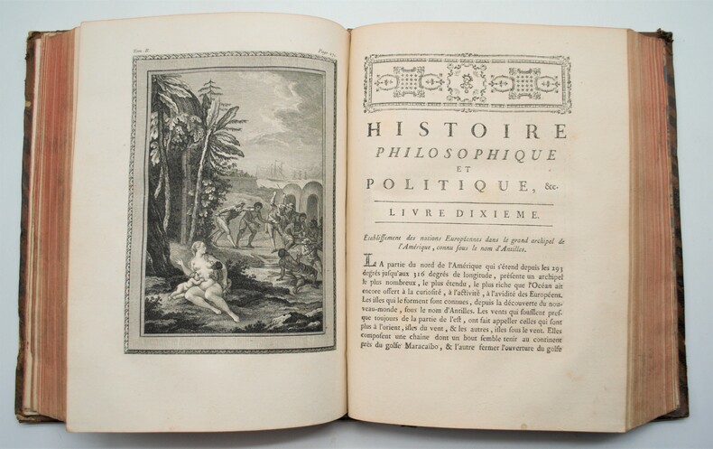
RAYNAL , (Guillaume-Thomas)
Histoire philosophique et politique des établissements et du commerce des européens dans les deux Indes.
Genève, Libraires associés, 1775. 2 volumes in-4 (sur 3) relié plein veau marbré époque , dos à nerfs orné avec pièce de titre rouge et tomaison verte ,tranches rouge , IV- VIII- 719pp- VIII- 662 pp- Portrait de l'auteur dessiné par Cochin , 4 figures gravées hors-texte, 2 vignettes d'en-tête par Marillier et 3 cartes dépliantes (golfe du Mexique, Amérique méridionale, Océan Indien et mer du Sud avec les Philippines et la Nouvelle Hollande).Manque le 3eme tome , coiffes usées ,manque aux dos, qlqs feuillets légèrement brunis , tome 2 mouillure marginale sur les 20 premières pages , traces de vieille humidité en fin d’ouvrage.
Bookseller reference : PHO-1037
|
|
|
RAYNAL (Guillaume-Thomas). DIDEROT (Denis). HOLBACH (Baron d').
Histoire philosophique et politique des établissements et du commerce des européens dans les deux Indes.
A Genève, chez les libraires associés, 1775 3 tome in-4 (26 x 20 cm) de (4) -IV-III-VIII-719, (4) -VIII-662 et (4) -VIII-658 pages. L'illustration comprend un portrait de l'Auteur gravé par Legrand d'après Cochin, 7 planches hors texte non signées, 4 cartes repliées aux contours colorés époque et 3 vignettes en-tête de Marillier. , relié plein veau blond, dos à nerfs ornés avec titre, tomaison et « rel. par Langlois à Lyon »en pied, filets sur les plats, tranches marbrées, coins usés, coiffes T1 et 3 un peu usés Première édition publiée au format in-4 établie sur la deuxième édition originale.
Bookseller reference : PHO-1053
|
|
|
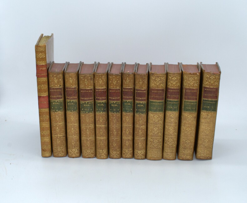
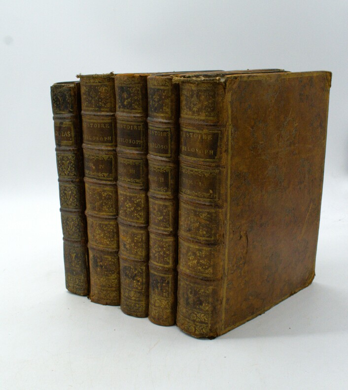
RAYNAL, Guillaume Thomas.
Histoire philosophique et politique des établissements et du commerce des européens dans les deux Indes, suivi du supplément à l’histoire philosophique...& Tableaux pour l’intelligence et vérification des résultats du commerce...
La Haye, Gosse et s.e., 1774-1781,11 volumes in 8°et 1 Atlas in-4, texte; XII-585, XII-386, XIII-586, XII-508, XII-407, VI-375 (1), XI-430 pages ,chaque volume comporte une gravure en frontispice d'après Eisen et une grande carte dépliante, et pour le supplément; XVI-604pp.,XV-574pp.,XV-492pp.,VIII-434pp.,avec un titre séparé Tableaux pour l’intelligence … 2ff. Et 23 tableaux dépliants ,reliure d'époque en plein veau ,dos lisse ornés,filets aux plats et roulettes à l’intérieur, tranches rouges , quelques coiffes usées, petits trous de ver,un tableau déchiré et son Atlas in-4 , 23pp. Et 50 cartes , relié pleine basane racinée époque, dos lisse avec pièce de titre et tomaison, petits frottements , coins usés
Bookseller reference : PHO-1474
|
|
|
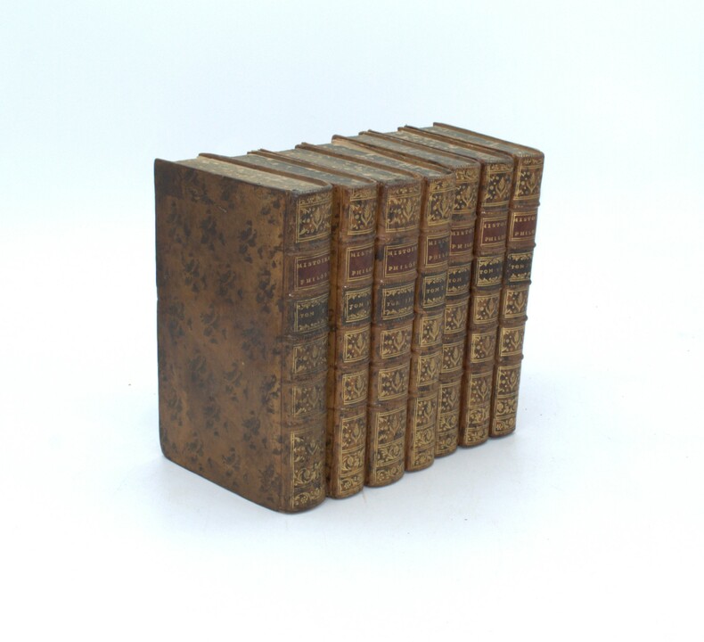
RAYNAL, Guillaume Thomas.
Histoire philosophique et politique des établissements et du commerce des européens dans les deux Indes
La Haye, Gosse, 1774, 7 volumes in 8°, XII-585, XII-386, XIII-586, XII-508, XII-407, VI-375 (1), XI-430 pages, chaque volume comporte une gravure en frontispice d'après Eisen et une grande carte dépliante, relié plein veau tacheté époque, dos à nerfs ornés avec pièce de titre rouge et tomaison noire, tranches tachetées bleues, exlibris manuscrit aux titres, quelques coins usés, petits accrocs, reliure en bel état, texte seul.
Bookseller reference : PHO-1489
|
|
|
RAYNAL (Guillaume-Thomas).
Histoire philosophique et politique des établissements et du commerce des Européens dans les deux Indes.
Genève, Jean-Léonard Pellet, 1780. 5 volumes in-4, 4 volumes et 1 Atlas, relié plein veau époque, dos à nerfs avec pièces de d’auteur et titre rouge et tomaison verte, tranches mouchetées, portrait, XVI, 741 pp., 1 pl.; front., (2 ff.), VIII, 485 pp.; front., XV, 629 pp.; front., (2 ff.), VIII, 770 pp., (1 f.); 22 pp., (1 f. bl.), 50 cartes (49+17bis) colorisées sur papier fort et bleuté et 23 tableaux dépliants. Reliure très frottée avec importantes épidermures et petits manques, manques la pièce de titre tome 1, portrait détaché.
Bookseller reference : PHO-1649
|
|
|
RAYNAL (Guillaume Thomas François), abbé - BONNE (Rigobert)
Histoire philosophique et politique des établissements et du commerce des Européens dans les deux Indes & Atlas de toutes les parties connues du globe terrestre, dressé pour l'histoire Philosophique et Politique des Établissements et du Commerce des Européens dans les deux Indes.
Genève, Pellet, 1780, 5 volumes in-4, 4 de texte et un atlas in-4, Texte ; portrait, XVI, 741 pp., 1 pl.; front., (2 ff.), VIII, 485 pp.; front., XV, 629 pp.; front., (2 ff.), VIII, 770 pp., (1 f.), Atlas ; 2f., 28pp. ; illustré complet des 50 cartes (chiffrées 1-49 et 17 bis) ; quelques cartes mal chiffrées et 23 tableaux de statistiques in fine, la plupart dépliants. Rousseurs éparses, feuillets légèrement brunis par places. Tampons humides "Bibliothèque populaire de Bordeaux". Reliure Texte ; Basane fauve marbrée de l'époque, dos à nerfs ornés, triple filet doré encadrant les plats, Atlas ; veau brun marbré de l'époque, dos à nerfs orné, fleurons tulipes entre caissons, tranches marbrées, filet à froid encadrant les plats, double filet doré sur coupes 2 coiffes arasées, une arrachée, petits chocs à 2 autres, frottements et épidermures, coins très émoussés, mors fendillés aux entrées, coins émoussés, tranches marbrées (atlas).
Bookseller reference : PHO-1926
|
|
|
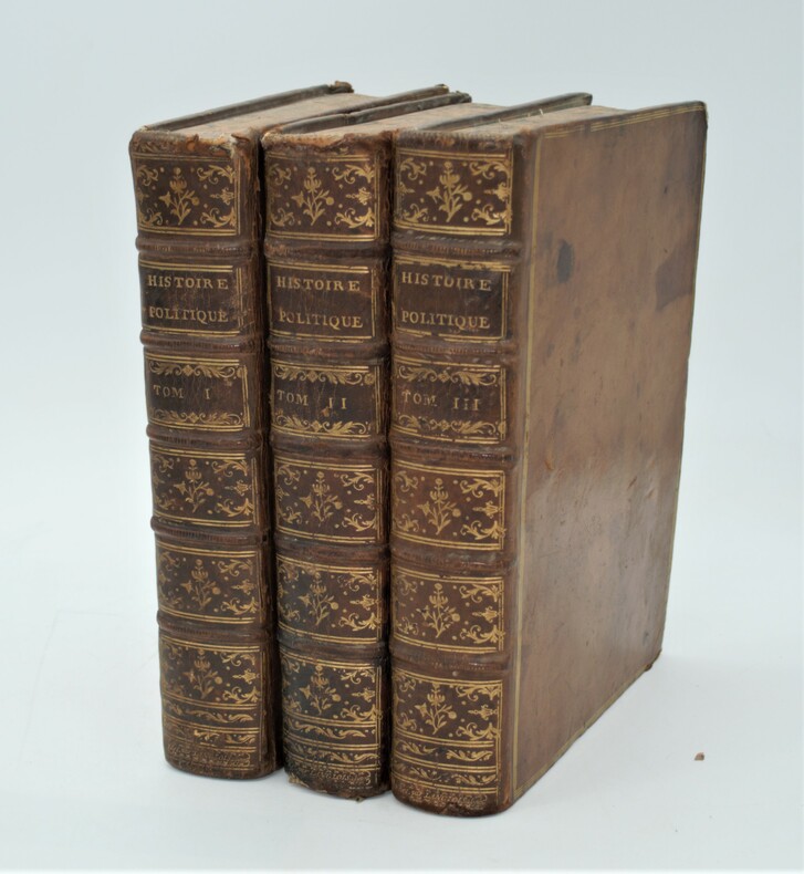
RAYNAL (Guillaume-Thomas)
Histoire philosophique et politique des établissemens et du commerce des Européens dans les deux Indes. 10 vol. et ATLAS de toutes les parties connues du globe terrestre, dressé pour l'Histoire philosophique...
Genève, Pellet, 1781. 10 volumes in-8, plein veau brun lisse, triple filet d'encadrement aux coins étoilés sur les plats, dos orné, pdt et de tomaison, tranches marbrées, frontispices et tableaux. ATLAS : in-4, demi-veau, dos orné, pdt, tr. jaspées, 50 cartes et 23 tableaux.
Bookseller reference : 6572
|
|
|
REBILLON ARMAND
ATLAS HISTORIQUE TOME III - LES TEMPS MODERNES - Les grandes découvertes de la fin du XVe à la fin du XVIIIe siècle - La , l' Allemagne au XVIe et XVIIIe siècle France jusqu'en 1660 - La monarchie Autrichienne - La bohême - La confédération Suisse - La Ru
PRESSES UNIVERSITAIRE DE FRANCE. 1937. In-8. Broché. Bon état, Couv. convenable, Dos satisfaisant, Intérieur frais. 19 pages augmentées de nombreuses cartes des pays du Monde. . . . Classification Dewey : 912-Atlas, cartes et plans
Bookseller reference : RO80192480
|
|
|
REBILLON ARMAND
ATLAS HISTORIQUE - III - LES TEMPS MODERNES.
LES PRESSES UNIVERSITAIRES DE FRANCE. 1937. In-8 Carré. Broché. Etat d'usage. Tâchée. Dos frotté. Intérieur frais. 23 pages augmentées de XXIV planches depliantes en noir et blanc (cartes). AVEC LA COLLABORATION DE VICTOR-L. TAPIE.

|
|
|
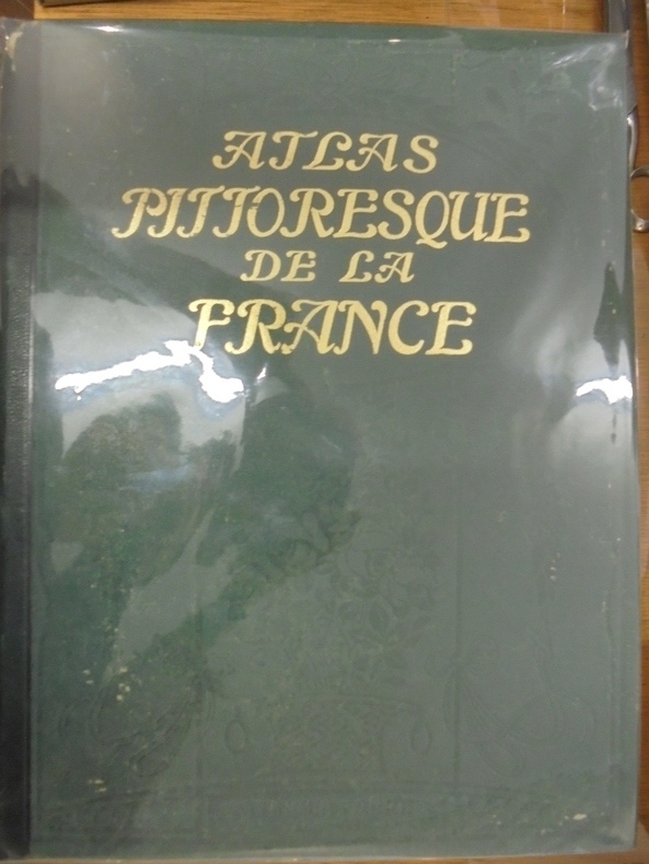
Reclus, Onesime
ATLAS PITTORESQUE DE LA FRANCE - RECEUIL de vues geographiques et pittoresques de tous les Departements, accompagnees de notices geographiques et de legendes explicatives. 3 Tomes
Paris, Societe des Atlas Pittoresques (Editions Attinger), 1909/1910. 600pp. environ pour chaque exemplaire. Grand In-4°, avec reliure de l'éditeur en chagrin vert. Illustré avec abondants photos et illustrations en NB.
Bookseller reference : ATLAS7M
|
|
|
RECLUS Onésime.
Atlas Pittoresque de la France. Fascicule XXIX : Puy-de-Dôme, Basse-Pyrénées, Hautes-Pyrénées.
ATTINGER FRERES. Non daté. In-Folio. Broché. Etat passable, 1er plat abîmé, Dos satisfaisant, Intérieur acceptable. Paginé de 97 à 144. Nombreuses photos et quelques cartes en noir et blanc, dans le texte. Déchirures sur le 1er plat, avec pliures.. . . . Classification Dewey : 912-Atlas, cartes et plans
Bookseller reference : RO80050374
|
|
|
RECLUS Onésime
Atlas Pittoresque de la France. TOMES 1, 2, 3 et 4
LES EDITIONS PITTORESQUES. 2ème édition. Non daté. In-4. Cartonnage d'éditeurs. Bon état, Couv. convenable, Dos satisfaisant, Intérieur frais. 399 + 399 + 399 + 399 pages. Nombreuses photos, illustrations et cartes en noir et blanc, dans le texte et hors-texte.. . . . Classification Dewey : 912-Atlas, cartes et plans
Bookseller reference : RO80118089
|
|
|
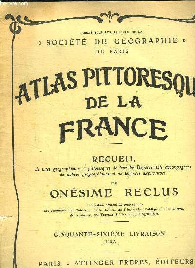
RECLUS ONESIME.
ATLAS PITTORESQUE DE LA FRANCE 65e LIVRAISON : JURA.
ATTINGER.. Non daté. In-4. Broché. Bon état, Couv. remarquable, Dos satisfaisant, Intérieur acceptable. De la page 257 à la page 272. Nombreuses photos en noir et blanc dans le texte.. . . . Classification Dewey : 912-Atlas, cartes et plans
Bookseller reference : R150166044
|
|
 Receive by email
 Download as PDF document
 RSS feed


