|
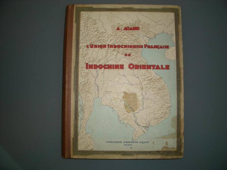
AGARD (A.)
l'Union Indochinoise ou Indochine Orientale - Régions Naturelles et Géographie Economique
Hanoï, Imprimerie d'Extrême-Orient, 1935. 1 volume in-4, 370 pp., couverture cartonnée illustrée d'éditeur, dos restauré en cuir. Richement illustré de XIV cartes en couleurs hors texte, de 48 cartes, plans et figures in texte et de 30 planches hors texte représentant plusieurs centaines de clichés photographiques. Très bon état. Un autre exemplaire, relié plein cuir moderne, est disponible à 320 uros.
Ссылка продавца : 10045
|
|
|
AGARD, A.
L'Union Indochinoise Française ou Indochine Orientale. Régions Naturelles et Géographie Economique .
Livre édité(e) à Hanoï par les Editions Imprimerie d'Extreme Orient en 1935, imprimé(e) en Français. En 1 Vol. au format Petit In-folio (30/33 cm) de 370 pp. Reliure Moderne, Plats Cartonnés Forts Titres Illustrés. Reliure d'Editeur.
Ссылка продавца : LRMO1122
|
|
|
AGNUS AINE
PLAN-OMNIBUS DE PARIS
CHEZ L'AUTEUR. NON DATE. In-12. Broché. Etat passable, Couv. convenable, Dos satisfaisant, Intérieur frais. Carte dépliante en couleurs de 28 panneaux format In-12. Déchirures de la carte. Aucun manque. Ruben adhésif. Recto : plan, verso : exposition universelle. . . . Classification Dewey : 912-Atlas, cartes et plans
Ссылка продавца : RO30115502
|
|
|
agriculture. atlas
Planches du cours complet d'agriculture, atlas de 356 planches d'agriculture, r
sd (debut XIXe, fort volume in8,, reliure demi basane bleue,, dos a nerfs, fleurons dorés, titre doré
Ссылка продавца : 14536
|
|
|
Aharoni, Yohanan and Michael Avi-Yonah
The Modern Bible Atlas. [By Yohanan Aharoni and Michael Avi-Yonah]. Foreword by Magnus Magnusson. Revised edition.
London, Boston & Sydney: Allen & Unwin 1979. Unpaginiert. 4° (25-35 cm). Orig.-Leinenband mit Orig.-Schutzumschlag. [Hardcover / fest gebunden].
Ссылка продавца : 154751

|
|
|
Aharoni, Yohanan and Michael Avi-Yonah
The Modern Bible Atlas. Foreword by Magnus Magnusson. Revised edition.
London, Boston & Sydney: Allen & Unwin 1979. Unpaginiert. 4° (25-35 cm). Orig.-Leinenband mit Orig.-Schutzumschlag. [Hardcover / fest gebunden].
Ссылка продавца : 99370

|
|
|
Ahlmann, Hans W:son. Huvudredaktör
Norden i text och kartor.
Stockholm., Generalstabens Litografiska Anstalts Förlag., 1976. 116S. mit zahlreichen farbigen Karten (und Statistiken). Zustand: Aus einer Institusbibliothek ausgeschieden, Einbandkanten minimal berieben, Titelblatt und letzte Seite mit Bibliotheksstempel. 4°. OPappband.
Ссылка продавца : 043017
|
|
|
Aimond (Charles)
La France et ses colonies.
français In-12 de 442 pp. + cartes in fine ; demi-toile de l'éditeur, plats cartonnés. Cours de géographie, classe de première.
|
|
|
Air France
Itinéraire long courriers (Long-distance flights) : Europe, Amérique du Sud, Afrique
Service Publicité d'Air France. 1973. In-4. Broché. Bon état, Couv. convenable, Dos satisfaisant, Intérieur frais. 9 pages augmentées de quelques cartes en couleurs,dans et hors texte. Relié par 2 agraffes. Texte en français et anglais.. . . A l'italienne. Classification Dewey : 912-Atlas, cartes et plans
Ссылка продавца : R200103168

|
|
|
Akademie für Raumforschung und Landesplanung
Deutscher Planungsatlas - Band 1 Nordrhein Westfalen
Hannover, Curt R. Vincentz Verlag, 1982. gr.Folio(56x39cm), 7 Bll.(Inhalt), 101 Karten(komplett), gebundene Leinenmappe
Ссылка продавца : 7-0-645

|
|
|
AKISATO RITO. [SHUNCHÔSAI NOBUSHIGE (Takhera) - Dessinateur/draughtsman].
[Miyako Meisho Zue]. Miyako-mei-sho. Dzu-yé. Ecrit par un noble Sugahara Tame-toshi-Kiyo. Dessiné par Takihara Shunchosai.
Kyoto, 1780 (1786). 1780 5 vol. in-8° (260 x 184 mm.) de : [60] ff.; [51] ff.; [52] ff.; [58] ff.; [76] ff.; plus de 250 gravures sur bois dont une grande partie sur double-page; texte gravé sur bois. Brochage éditeur dépoque, cartonnage bleu, pièces de titre en japonais, titre manuscrit en français sur les couvertures.
Ссылка продавца : 4225

|
|
|
AKRELL C.
RES-KARTA ÖFVER SVERIGE, SÖDRA DELEN
Adolf Bonnier, Stockholm. 1860. In-Plano. En feuillets. Etat du neuf, 1er plat abîmé, Dos abîmé, Intérieur acceptable. Carte dépliable entoilée en couleur, d'env. 73/53 cm. Petits manques en surface de la couverture.. . . . Classification Dewey : 912-Atlas, cartes et plans
Ссылка продавца : RO40200163
|
|
|
AKRELL C.
RES-KARTA ÖFVER SVERIGE, SÖDRA DELEN
Adolf Bonnier, Stockholm. 1860. In-Plano Carré. En feuillets. Etat du neuf. 1er plat abîmé. Dos abîmé. Intérieur acceptable. Carte dépliable entoilée en couleur, d'env. 73/53 cm. Petits manques en surface de la couverture. (Très rare) Avec Table des distances entre les villes au Sud de Gefle.

|
|
|
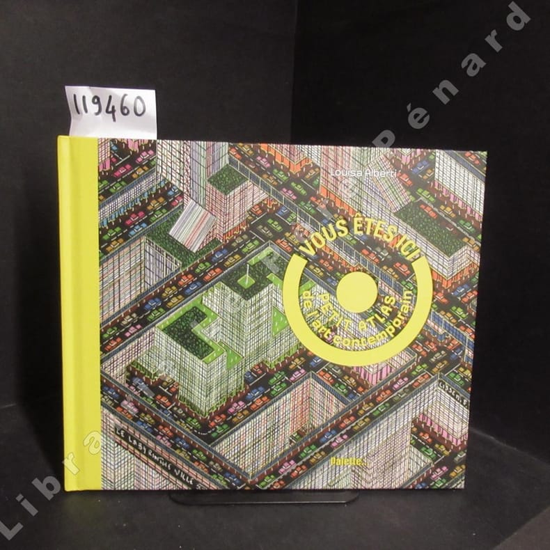
ALBERTI, Louisa
Vous êtes ici. Petit atlas de l'art contemporain.
2017 Editions Palette... - 2017 - In-4, format à l'italienne, cartonnage illustré de l'éditeur - 60 pages - Nombreuses reproductions photographiques en couleurs in et hoors-texte
Ссылка продавца : 119460
|
|
|
Albrecht, H. u.a
Diercke Heimatatlas für Berliner Grundschulen. Im Auftrage des Berliner Lehrervereins. UND: C. Diercke Karten zur Heimatkunde der Provinz Brandenburg. Eine Ergänzung zu den Schulatlanten des Verfassers.
Georg Westermann, Braunschweig ca. 1920. ca. 12 / VIII S. mit farbigen Karten, 4°, privat in einfachen Pappband eingebunden,
Ссылка продавца : 208586

|
|
|
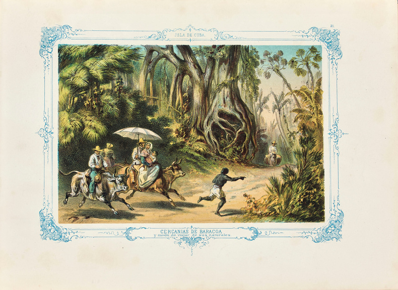
Album pintoresco de la isla de Cuba.
Album pintoresco de la isla de Cuba. L’un des rares témoignages sur la vie quotidienne à Cuba au XIXè siècle, illustré de 27 lithographies en couleurs.
Rare et bel album sur la vie cubaine des années 1850, entièrement lithographié en couleurs, conservé dans sa très décorative reliure en velours vert orné de fers rocailles dorés. [Berlin ou Hambourg], Storch & Kramer pour May y Cia, s.d. [c. 1851]. Petit in-folio oblong contenant 1 titre en chromolithographie, 27 chromolithographies, une carte dépliante de l’île et un plan dépliant de La Havane (infime déchirure ds. la marge bl.). Relié en velours vert de l’éditeur, large encadrement rocaillé en or autour des plats avec titre en lettres dorées au centre, tranches dorées. Reliure de l’époque. 242 x 342 mm.
Ссылка продавца : LCS-17530
|
|
|
ALES
CARTE DU DEPARTEMENT DE COTE D'OR EXTRAITE DU PETIT ATLAS NATIONAL N°20
BLAISOT. XIXe SIECLE. In-Folio. En feuillets. Bon état, Couv. convenable, Dos satisfaisant, Mouillures. Une carte gravée sur acier en noir et blanc accompagnée d'une gravure en noir et blanc. 35 x 26 cm.. . . A l'italienne. Classification Dewey : 912-Atlas, cartes et plans
Ссылка продавца : R160112989

|
|
|
ALES
CARTE DU DEPARTEMENT DE L'AIN EXTRAITE DU PETIT ATLAS NATIONAL N°1
BLAISOT. XIXe SIECLE. In-Folio. En feuillets. Etat d'usage, Livré sans Couverture, Dos satisfaisant, Mouillures. Une carte gravée sur acier en noir et blanc accompagnée d'une gravure en noir et blanc. 26 x 35 cm.. . . A l'italienne. Classification Dewey : 912-Atlas, cartes et plans
Ссылка продавца : R160112982

|
|
|
ALES
CARTE DU DEPARTEMENT DE L'ALLIER EXTRAITE DU PETIT ATLAS NATIONAL N°3
BLAISOT. XIXe SIECLE. In-Folio. En feuillets. Etat d'usage, Livré sans Couverture, Dos satisfaisant, Mouillures. Une carte gravée sur acier en noir et blanc accompagnée d'une gravure en noir et blanc. 26 x 35 cm.. . . A l'italienne. Classification Dewey : 912-Atlas, cartes et plans
Ссылка продавца : R160112983

|
|
|
ALES
CARTE DU DEPARTEMENT DE L'ARDECHE EXTRAITE DU PETIT ATLAS NATIONAL N°6
BLAISOT. XIXe SIECLE. In-Folio. En feuillets. Bon état, Couv. convenable, Dos satisfaisant, Intérieur frais. Une carte gravée sur acier en noir et blanc accompagnée d'une gravure en noir et blanc. 26 x 35 cm.. . . . Classification Dewey : 912-Atlas, cartes et plans
Ссылка продавца : R160112985

|
|
|
ALES
CARTE DU DEPARTEMENT DE L'AUBE EXTRAITE DU PETIT ATLAS NATIONAL N°9
BLAISOT. XIXe SIECLE. In-Folio. En feuillets. Bon état, Couv. convenable, Dos satisfaisant, Intérieur frais. Une carte gravée sur acier en noir et blanc accompagnée d'une gravure en noir et blanc. 26 x 35 cm.. . . A l'italienne. Classification Dewey : 912-Atlas, cartes et plans
Ссылка продавца : R160112986

|
|
|
ALES
CARTE DU DEPARTEMENT DE L'AVEYRON EXTRAITE DU PETIT ATLAS NATIONAL N°11
BLAISOT. XIXe SIECLE. In-Folio. En feuillets. Bon état, Couv. convenable, Dos satisfaisant, Intérieur frais. Une carte gravée sur acier en noir et blanc accompagnée d'une gravure en noir et blanc. 35 x 26 cm.. . . . Classification Dewey : 912-Atlas, cartes et plans
Ссылка продавца : R160112987

|
|
|
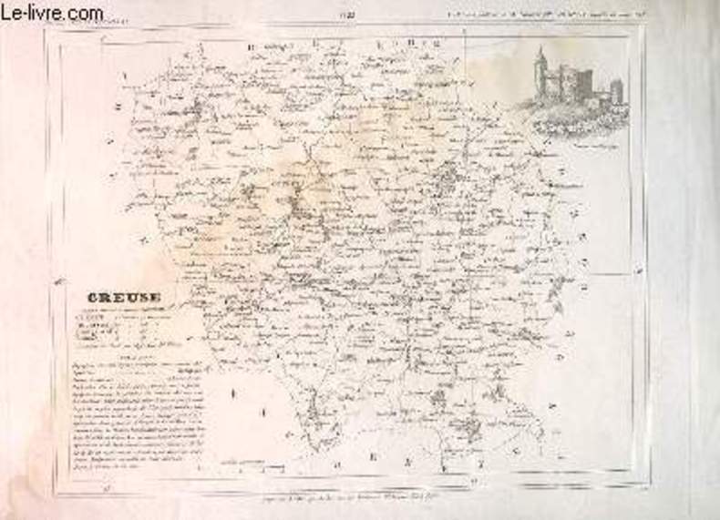
ALES
CARTE DU DEPARTEMENT DE LA CREUSE EXTRAITE DU PETIT ATLAS NATIONAL N°22
BLAISOT. XIXe SIECLE. In-Folio. En feuillets. Bon état, Couv. convenable, Dos satisfaisant, Intérieur frais. Une carte gravée sur acier en noir et blanc accompagnée d'une gravure en noir et blanc. 35 x 26 cm.. . . . Classification Dewey : 912-Atlas, cartes et plans
Ссылка продавца : R160112990
|
|
|
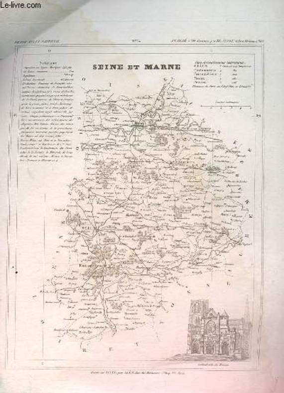
ALES
CARTE DU DEPARTEMENT DE LA SEINE ET MARNE EXTRAITE DU PETIT ATLAS NATIONAL N°74
BLAISOT. XIXe SIECLE. In-12. Broché. Bon état, Couv. convenable, Dos satisfaisant, Mouillures. Une carte gravée sur acier en noir et blanc accompagnée d'une gravure en noir et blanc. 35 x 26 cm.. . . . Classification Dewey : 912-Atlas, cartes et plans
Ссылка продавца : R160112991
|
|
|
ALES
CARTE DU DEPARTEMENT DES BASSES ALPES EXTRAITE DU PETIT ATLAS NATIONAL N°4
BLAISOT. XIXe SIECLE. In-Folio. En feuillets. Bon état, Couv. convenable, Dos satisfaisant, Mouillures. Une carte gravée sur acier en noir et blanc accompagnée d'une gravure en noir et blanc. 26 x 35 cm.. . . A l'italienne. Classification Dewey : 912-Atlas, cartes et plans
Ссылка продавца : R160112984
|
|
|
ALES
CARTE DU DEPARTEMENT DU CANTAL EXTRAITE DU PETIT ATLAS NATIONAL N°14
BLAISOT. XIXe SIECLE. In-Folio. En feuillets. Bon état, Couv. convenable, Dos satisfaisant, Intérieur frais. Une carte gravée sur acier en noir et blanc accompagnée d'une gravure en noir et blanc. 26 x 35 cm.. . . A l'italienne. Classification Dewey : 912-Atlas, cartes et plans
Ссылка продавца : R160112988

|
|
|
Alexander Weltatlas
Deutschland und die Welt. Hier: Kurzausgabe für Bayern. Mit eingebundenem Länderteil Mit 17 und 72 mehrfarbigen Kartenseiten.
Stuttgart, Klett., 1989. 4°. [24,4 : 33,8 cm]. 23, 80 Seiten. Mit einem Namenregister für Bayern und einem Arbeitsregister. Farbig illustrierter Originalkunststoffband. (Verlagsschildchen auf Deckel). - Ein sehr gut erhaltenes, makelloses Exemplar; druckfrisch. 1. Auflage.
Ссылка продавца : 57210AB

|
|
|
Alexander Weltatlas
Grundausgabe. Mit 104 mehrfarbigen Kartenseiten und einem Anhang mit Himmelskunde.
Stuttgart, Klett., 1978. 4°. [24,4 : 33,8 cm]. XVI/138 Seiten. Mit einem Namenregister. Farbig illustrierter Originalkunststoffband. (Stempel/Besitzvermerk auf Titel). - Ansonsten ein sehr gut erhaltenes, annähernd neuwertiges Exemplar ohne weitere Eintragungen. 1. Auflage.
Ссылка продавца : 57211AB

|
|
|
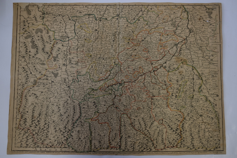
Alexis-Hubert Jaillot
Les élections de comenge, d’Esterac, partie de celles de rivière Verdun & d’Armagnac, le Pays des quatre Vallées, le Nébouzan et le Comté de Foix
1695, à Paris chez l'Auteur. 65x47cm (marges à ras). Carte réalisée par Jaillot. Épreuve originale de 1695 tirée de l'Atas François. Colorisation des limites datant de l'époque. Deux restaurations au coin gauche de la marge supérieure. Pliure verticale au milieu de la feuille. Brunissure normale. Charmant exemplaire
Ссылка продавца : CARTE2T10
|
|
|
ALEXIS-M.G.
La Belgique pittoresque. Geographie descriptive, physique, politique, economique et historique. Ouvrage illustre de nombreuses cartes et gravures.
Liege, H. Dessain, sans date (ca.1900). 1 vol. in 4 broche de 384 pages.
Ссылка продавца : 31411
|
|
|
ALEXIS-M.G.
La Belgique pittoresque. Geographie descriptive, physique, politique, economique et historique. Ouvrage illustre de nombreuses cartes et gravures.
1 vol. in 4 broche de 384 pages. Bon etat. [P-44]
|
|
|
ALGERIE - PELET ( Lieutenant Général )
Ensemble de 3 cartes gravées ORAN - CONSTANTINE - ALGER. 1844.
S.N. S.L. 1844 Ensemble de 3 cartes gravées entoilées réunies sous chemise et étui cartonnage de papier maroquiné acajou ornés de roulette et filets "en dents de rats" d'encadrement dorés, titrés "Cartes d'Afrique" en lettres d'or ( Présentation de l'époque ). Très bel exemplaire dans son élégant étui orné de l'époque, les cartes sont très fraîches.- 1/ Carte de la province d'Oran. 90.5 x 116.5 cm. - 2/ Carte de la province de Constantine. 57.5 x 90 cm. - 3/ Carte de la province d'Alger. 57.5 x 90 cm.[ALGÉRIE]. PELET ( Lieutenant général ). ENSEMBLE DE 4 CARTES entoilées et pliées, regroupées dans une chemise à rabats sous étui carton à dos de basane décoré de 2 fers Rocaille dorés, titre doré ( Étui de lépoque ).-CARTE DE LA PROVINCE DE CONSTANTINE. Paris, 1844. ( 91 X 81 cm environ ).-CARTE DE LALGÉRIE. Paris, 1846. ( 102 X 67 cm environ ).-CARTE DE LA PROVINCE DORAN. Paris, 1846. ( 137 X 90 cm environ ).-CARTE DE DE LA PROVINCE DALGER. Paris, 1846. ( 110 X 91 cm environ ).
Ссылка продавца : 561776

|
|
|
ALI SEREF PASHA, (1840-1907).
[MAP of AUSTRIA-HUNGARY] Avusturya-Macaristan.; Sair Türkiya tevâir-i hazret Abdülhamid Han-i Sânî'den Maarif-i Umumiye-i Nezâreti Celilesi'nin ruhsatiyle Fransa tâb' meshurlarindan Haset'in Fransa cografya-yi encümen âzâsindan mütesekkil heyet mârifetiyle tanzim olunan Mükemmel Cografya Atlasi'nin tercümesi olunarak bu def'â Erkân-i Harbiye-i Umumiye Dairesi Besinci Fen Subesine mâmur piyade miralaylarindan saadetlû Ali Seref Pasa'ya tersim ettirilmistir.
Very Good Turkish, Ottoman (1500-1928) Original color map. Folded. Oblong folio. (36 x 52 cm). In Ottoman script. Scale: 1/3500000. Good and clean copy. Litho. Ali Seref Pasha was born in 1840 in Istanbul. At the same time his nickname is Hafiz. In 1862 he was sent to Paris by the order of the Turkish (Ottoman) Military Academy for the study of cartography. In Paris (1868) he prepared an atlas containing 22 maps called Yeni Atlas (New Atlas) on the rank of Mülâzimevvel (Captain). In 1896, while he was working for the General Staff in the rank of Lieutenant General, he translated Kiepert's map of Anatolia into Turkish. He prepared a map of Rumelia consisting of 73 sheets and prepared a large wall map for the schools. (Source: Türk haritacilig tarihi, (1895-1995).; SERBETÇI, Muzaffer.).
|
|
|
ALI SEREF PASHA, (1840-1907).
[MAP of GERMANY] Sair Türkiya tevair-i cenâb-i cihanbasi ve bî der tavsih saltanat-i Osmanî el-Gazi Abdülhamid Han-i Sâni'de meshur Haset tarafindan bastirilip Fransa Encümen-i Cografya âzâlarindan mütesekkil komisyonu mahsusasina atid-i rems oldugu son def'â Atlas-i Maarif-i Umumiye-i Nezâreti Celilesi ruhsatiyle Erkân-i Harbiye-i Umumiye Dairesi Besinci Fen Subesine mâmur piyade miralaylarindan Ali Seref Pasa marifetiyle tersim ve tercüme edilerek tâb edilmistir.
Very Good Turkish, Ottoman (1500-1928) Original color map. Folded. Oblong folio. (37 x 52 cm). In Ottoman script. Scale: 1/3500000. Good and clean copy. Color lithograph. Ali Seref Pasha was born in 1840 in Istanbul. At the same time his nickname is Hafiz. In 1862 he was sent to Paris by the order of the Turkish (Ottoman) Military Academy for the study of cartography. In Paris (1868) he prepared an atlas containing 22 maps called Yeni Atlas (New Atlas) on the rank of Mülâzimevvel (Captain). In 1896, while he was working for the General Staff in the rank of Lieutenant General, he translated Kiepert's map of Anatolia into Turkish. He prepared a map of Rumelia consisting of 73 sheets and prepared a large wall map for the schools. (Source: Türk haritacilig tarihi, (1895-1995).; SERBETÇI, Muzaffer.).
|
|
|
Ali Tanoglu. Sirri Erinc. Erol Tümertekin. Hazirliyanlar - Prepared by
Türkiye Atlasi. Atlas of Turkey.
Istanbul., Milli Egitim Basimevi., 1961. 87 meist farbige Karten auf ca. 100S. Enthält Karten zur Topographie, Klima, Vegetation, Hydrologie, Bevölkerung, Landwirtschaft, Industrie Handel und Kommunikation, Verwaltung. Zustand: Ausgeschiedenes Bibliotheksexemplar (Seminarbibliothek), unterer Rücken mit Resten eines Aufklebers, Titelblatt gestempelt. Gross-Folio. OLeinen.
Ссылка продавца : 041077
|
|
|
ALIMEN (H.)
Atlas de la préhistoire vol. I
Paris, Boubée, 1950. In-8 (185x135mm) broché ; 205 p. Nombreuses ill. et cartes dépliantes. Très bon état général.
Ссылка продавца : 23708
|
|
|
ALIMEN H
ATLAS DE PREHISTOIRE. 1
Paris, Boubée et Cie 1950. In-12 carré broché de 205 pages. Cartes, 86 figures dans le texte, 1 tableau et 20 planches en noir et en couleurs. Très bon état
|
|
|
Alison Archibald ; Johnston Alex Keith Atlas
History of Europe from the commencement of The French Revolution to the Restoration of the Bourbons in MDCCCXV - 14 volumes plus atlas
William Blackwood and Sons Edinburgh and London 1849. 5th or later Edition. Hardcover. Very Good/No Jacket. 14 volumes plus atlas complete. All fully bound in leather with gilt decoration - to fascias spines and edges - and titling. All have marbled papertrims and frontis and end papers. This is a FABULOUS set of this popular loquacious history of Europe with the first major account of the French Revolution. It is smart handsome gentlemanly and very clubbable. Some of the books have wear from shelving and are scuffed but this only adds a genial dignity and character. All have binder labels T. Sowler Manchester - the very model of a Victorian businessman on the front pastedowns. Spines have five ridges and six panels. The Atlas 108 pages - published 1850 contains maps of countries and towns and plans of 'battles and sieges &c.' The covers are worn and scuffed. Within there are some small storage marks about. The pages are clean startlingly bright and clear finely detailed and the colours for various regiments fresh. Volume 1 633 pgs; 1849: wear to edges and spine but dignified and secure. The contents are tight and clean. Covers 1774-1789. Vol 2 693 pgs; 1849. In very good handsome condition. Light wear bright gilt. Inside the contents are clean and fresh. There is a silk bookmark. 1789 - 1793. Vol 3 635 pgs; 1749. The stamped decoration as with all other volumes is neat and unworn. The spine has some wear but is benign and kindly. The pages are clean and comfortable. Covers 1795. Vol. 4 654 pages; 1849. A lovely atmospheric copy. At last the story moves on beyond France. The pages are fresh. 1795-1799. Vol V 658 pgs. Neat contented bright. 1799 -1801. Vol 6 670 pgs. Nelson Pitt Napoleon! The odd storage stain. Otherwise very clean. 1801-05. Vol 7 690 pgs. Some age related marks. Tidy and handsome. Fox Prussia Clive of India! 1805-07. Vol 8 696 pgs. Tight confident clean. Some cover wear. Wellesley Napoleon Peninsula Wars. 1807-09. Vol 9. A happy book. Some wear. Spain George III! Pages exceptional. Vol. 10 630 pgs. Some scuffing and wear. Wellington the Emperor South America Turks Russians! Pages very clean. 1810-12. Vol 11 637 pgs. Some wear to the covers. Contents are smart. Moscow Germany Generals! 1812-13. Vol 12 640 pgs. Confident benign copy with some spine wear. Pages very secure and certain. Wellington in France Blucher Napoleon on the run. 1813-14. Vol 13 664 pgs. Edge and spine wear. Pages vigorous and healthy. Come-uppances America Vienna decides! 1814-1815 1814 is the date when Alison had the idea of this history. Vol 14 644 pgs. Some aged wear to the covers. The pages are startlingly healthy. Waterloo St Helena The First Reform Bill contemporary judgements. 1815 and index. Oh happy person who owns this THRILLING story as told in these wonderful and REMARKABLE volumes. fk. Our orders are shipped using tracked courier delivery services. William Blackwood and Sons, Edinburgh and London hardcover
Ссылка продавца : azgs

|
|
|
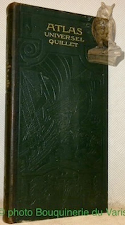
ALLAIN M. MAURICE
ATLAS UNIVERSEL QUILLET, PHYSIQUE, ECONOMIQUE, POLITIQUE, 2 VOLUMES: I. LE MONDE FRANCAIS (FRANCE ET COLONIES), II. L'EUROPE, L'ASIE, L'AFRIQUE, L'AMERIQUE, L'OCEANIE
Librairie Aristide Quillet. 1923-1925. In-Folio Carré. Relié demi-cuir. Etat d'usage. Coins frottés. Dos très frotté. Quelques rousseurs. 42 cartes en couleur sur doubles-pages + 199 pages d'Index pour le vol. I, et 57 cartes en couleur sur doubles-pages + 59 pages d'Index pour le vol. II. Reliures d'éditeur avec titres dorés sur le dos et le 1er plat; motifs décoratifs en relief sur le dos et les plats. Le Monde français: Planisphère physique. Planisphère politique. France physique. France hypsométrique. Massif central. France de l'Est. France économique, etc. L'Europe, L'Asie, L'Afrique, L'Amérique, L'Océanie: Europe géologique. Europe physique. Europe politique. Iles britanniques. Scandinavie. Allemagne. Etats balkaniques. Europe, cartes economiques. Pôle Nord. Asie géologique. Asie physique...

|
|
|
ALLAIN MAURICE
ATLAS UNIVERSEL QUILLET - LE MONDE FRANCAIS (FRANCE ET COLONIES)
LIBRAIRIE ARISTIDE QUILLET. non daté. In-Plano. Relié. Bon état, 2ème plat abîmé, Dos satisfaisant, Intérieur frais. 42 doubles pages de cartes dépliantes en couleurs + 19 pages.Reliure d'editeur avec titres dores sur le dos et le 1er plat; motifs decoratifs en relief sur le dos et les plats.. . . . Classification Dewey : 912-Atlas, cartes et plans
Ссылка продавца : RO30067293
|
|
|
ALLAIN MAURICE
ATLAS UNIVERSEL QUILLET - LE MONDE FRANCAIS (FRANCE et COLONIES).
LIBRAIRIE ARISTIDE QUILLET. 1923. In-Folio Carré. Relié. Bon état. Couv. convenable. Dos satisfaisant. Intérieur frais. 42 pages de cartes en couleur + 19 pages - Contre-plats jaspés - 32 PHOTOS DISPONIBLES - COPYRIGHT 1923.
|
|
|
ALLAIN Maurice
Atlas Universel Quillet, physique - économique - politique. France et Union Française.
LIBRAIRIE QUILLET Aristide. 1952. In-Folio. Cartonnage d'éditeurs. Bon état, Couv. convenable, Dos satisfaisant, Intérieur frais. 89 pages + une cinquantaine de doubles-planches (dont certaines dépliantes) illustrées de cartes en couleurs et de photos en héliogravure. Coiffes légèrement frottées.. . . . Classification Dewey : 912-Atlas, cartes et plans
Ссылка продавца : RO80159856
|
|
|
ALLAIN MAURICE
ATLAS UNIVERSEL QUILLET, PHYSIQUE, ECONOMIQUE, POLITIQUE, LE MONDE FRANCAIS (FRANCE ET COLONIES)
Librairie Aristide Quillet. 1923. In-Folio. Relié demi-cuir. Bon état, Couv. convenable, Dos satisfaisant, Quelques rousseurs. 199 pages. Illustré de nombreuses cartes en couleur, dont certaines sur planches dépliables. Reliure d'éditeur avec titres dorés sur le dos et le 1er plat; motifs décoratifs en relief sur le dos et les plats.. . . . Classification Dewey : 912-Atlas, cartes et plans
Ссылка продавца : RO40103346

|
|
|
ALLAIN MAURICE
ATLAS UNIVERSEL QUILLET, PHYSIQUE, ECONOMIQUE, POLITIQUE, LE MONDE FRANCAIS (FRANCE ET COLONIES)
Librairie Aristide Quillet. 1923. In-Folio Carré. Relié demi-cuir. Bon état. Couv. convenable. Dos satisfaisant. Quelques rousseurs. 199 pages. Illustré de nombreuses cartes en couleur, dont certaines sur planches dépliables. Reliure d'éditeur avec titres dorés sur le dos et le 1er plat; motifs décoratifs en relief sur le dos et les plats. Planisphère physique. Planisphère politique. France physique. France hypsométrique. Massif central. France de l'Est. France économique...

|
|
|
ALLAIN Maurice
Carte des Etats Balkaniques.
QUILLET Aristide. Non daté. In-Plano. En feuillets. Bon état, Livré sans Couverture, Dos satisfaisant, Intérieur frais. Carte dépliante en couleurs de 44 / 44 cm.. . . . Classification Dewey : 912-Atlas, cartes et plans
Ссылка продавца : RO80032900
|
|
|
Allain, Maurice
Atlas Universel Quillet. Physique - Économique - Politique.
Paris, Strasbourg, Bruxelles Librairie Aristide Quillet 1923. 2 Bde. 2° 57 Kart./59 S. Index, 42 Kart./19 (199)S. Index Ldr., vergold. Rück.-u. Deck.-Tit, Blindpräg. Kanten v. 1. Bd. leicht berieben, bestossen, hint. Gelenk gelockert, ober. u. unt. Kapitale v. 2. Bd. berieben sowie unt. Rück.-Gelenk etwas eingerissen, vord. Deck. leicht berieben, bestossen. Beide Bde. innen sauber erhalten.
Ссылка продавца : 55056AB
|
|
|
Allain, Maurice
Atlas Universel Quillet. Physique - Économique - Politique. 2 Bände: Band 1: Le Monde Français (France et Colonies); Band 2: L`Europe - L`Asie - L`Afrique - L`Amérique - L`Océanie.
Paris Strasbourg Bruxelles: Librairie Aristide Quillet, 1929. 42 farbige doppelbattgroße Karten, 200 S.; 57 farbige doppelbattgroße Karten, 59 S.; 2°; gebunden, Orig.-Halbleder, goldgeprägte Rückentitel;
Ссылка продавца : 139229

|
|
|
Allain, Maurice.
Atlas Universel Quillet. Physique - Economique - Politique. Deuxième partie: L’Europe - L’Asie - L’Afrique - L’Amérique - L’Océanie.
Paris, Librairie Aristide Quillet 1933, 59pages, reliure d'éditeur.
Ссылка продавца : 110190
|
|
|
Allan Atlas
Anthology of Renaissance Music:
New. unknown
Ссылка продавца : BNT1166 ISBN : 0393971708 9780393971705

|
|
|
Allan Atlas
Renaissance Music: Music in Western Europe 1400-1600
New. unknown
Ссылка продавца : BNT0457 ISBN : 0393971694 9780393971699

|
|
 Получить результаты поиска по электронной почте
 Загрузить результаты в формате PDF
  RSS-канал


