|
Daniel A. Atlas
Gardening with SPROUTS: A How-To Guide to Understanding Organic Gardening and Design
AuthorHouse 2009-03-06. Paperback. Used:Good. AuthorHouse paperback
Bookseller reference : DADAX1438930917 ISBN : 1438930917 9781438930916
|
|
|
Daniel A. Atlas
Gardening with SPROUTS: A How-To Guide to Understanding Organic Gardening and Design
AuthorHouse 2009-03-06. Paperback. Good. AuthorHouse paperback
Bookseller reference : SONG1438930917 ISBN : 1438930917 9781438930916
|
|
|
DARESSY (Georges)
Atlas Archéologique de l'Egypte.
Paris, Garnier, 2002. In-folio oblong, rel. pleine toile marine, titre doré au plat sup., sous jaquette d'édition illustrée en couleurs, 127 pp., 52 pl. en couleurs, index. Un cédérom inclus.
Bookseller reference : 591681
|
|
|
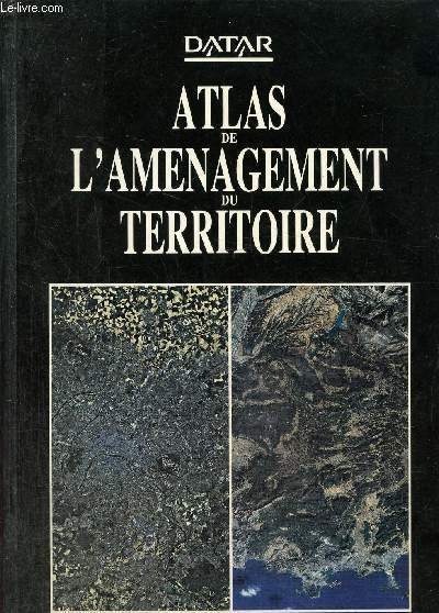
Datar
Atlas de l'amenegement du territoire
La documentation française. 1988. In-8. Relié. Bon état, Couv. convenable, Dos satisfaisant, Intérieur frais. 368 pages augmentées de nombreuses cartes en couleurs dans et hors texte.. . . . Classification Dewey : 912-Atlas, cartes et plans
Bookseller reference : RO80234341 ISBN : 2110020504
|
|
|
DAUPHINE
LES CARTES DU DAUPHINE - MASSIFS DU HAUT DAUPHINE : PELVOUX, ECRINS, OLAN, MIEJE - ECHELLE 1/50000. DIMENSION : 100 x 112 cm environ.
DIDIER ET RICHARD. NON DATE. In-Plano. Broché. Etat d'usage, Coins frottés, Dos satisfaisant, Intérieur acceptable. Carte en couleurs (recto uniquement) dépliante de DIMENSION : 100 x 112 cm environ.. . . . Classification Dewey : 912-Atlas, cartes et plans
Bookseller reference : ROD0108011
|
|
|
DAUDY Philippe
NAPLES.
reliure éditeur - 17,5x27 - 208 pp - 1964 - éditions RENCONTRE, Lausanne.Collection " ATLAS DES VOYAGES, RENCONTRE" dirigée par Charles-Henri FAVROD.Nombreuses illustrations dans et hors texte.
Bookseller reference : 4962
|
|
|
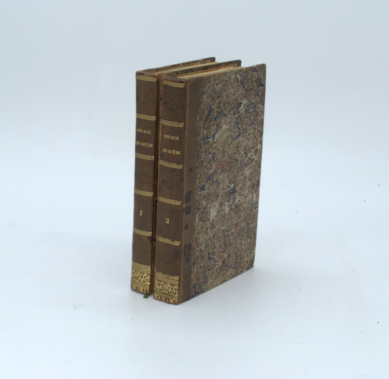
DAUMONT , Alexandre
Voyage en Suède, contenant des notions étendues sur le commerce, l'industrie, l'agriculture, les mines, les sciences, les arts et la littérature de ce royaume
Paris, Arthus Bertrand, 1834. 2 volumes in-8, (4)pp., 399pp.; ( 4), 416pp. , demi-veau havane, dos lisse avec titre, tranches jaunes ,complet des 10 planches qui ont été reliées en fin de tome II, second plat du tome II détachée , sinon bon état.
Bookseller reference : PHO-1353
|
|
|
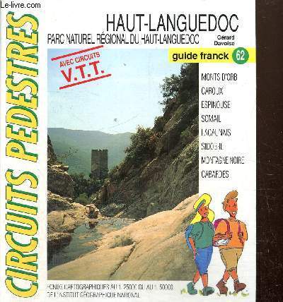
Davoise Gérard
"Haut-Languedoc - Parc naturel régional du Haut-Languedoc - Avec circuits VTT (Collection ""Circuits pédestres, Guides Francks"" n°62)"
Franck Mercier. 19996. In-8. En feuillets. Bon état, Couv. convenable, Dos satisfaisant, Intérieur frais. Environ 50 feuillets réunis dans un classeur. Nombreuses cartes en couleurs hors texte.. . . . Classification Dewey : 912-Atlas, cartes et plans
Bookseller reference : RO80239596
|
|
|
DAVIES & COMPANY
Carte maritime des abords de Marseille. Côte Sud Française.
ADMIRALTY. Oct 1913. In-Plano. En feuillets. Bon état, Couv. convenable, Dos satisfaisant, Intérieur bon état. Carte, noir et blanc, en double-planches de 102 /69 cm. Légendes en anglais.. . . . Classification Dewey : 912-Atlas, cartes et plans
Bookseller reference : RO20039473
|
|
|
DAVIES & COMPANY
Carte maritime de Toulon.
ADMIRALTY. 1916. In-Plano. En feuillets. Bon état, Couv. convenable, Dos satisfaisant, Intérieur frais. Carte, noir et blanc, en double-planches de 102 /69 cm. Légendes en anglais.. . . . Classification Dewey : 912-Atlas, cartes et plans
Bookseller reference : RO20039475
|
|
|
DAVIES & COMPANY
Carte maritime de la Côte Ouest Méditérranéenne.
ADMIRALTY. 1919. In-Plano. En feuillets. Etat d'usage, Couv. convenable, Dos satisfaisant, Intérieur bon état. Carte, noir et blanc, en double-planches de 102 /69 cm. Légendes en anglais.. . . . Classification Dewey : 912-Atlas, cartes et plans
Bookseller reference : RO20039476
|
|
|
DAVIES & COMPANY
Carte Maritime du Port de Malaga
ADMIRALTY. Non daté. In-Plano. En feuillets. Bon état, Couv. convenable, Dos satisfaisant, Intérieur bon état. Carte, noir et blanc, en double-planches de 70/50 cm. Légendes en anglais.. . . A l'italienne. Classification Dewey : 912-Atlas, cartes et plans
Bookseller reference : RO20039484
|
|
|
DAVIES & COMPANY
Carte Maritime de la Mer du Nord.
ADMIRALTY. 1922. In-Plano. En feuillets. Bon état, Couv. convenable, Dos satisfaisant, Quelques rousseurs. Carte, noir et blanc, en double-planches de 102 /69 cm. Légendes en anglais. Quelques marques rouges.. . . . Classification Dewey : 912-Atlas, cartes et plans
Bookseller reference : RO20039488
|
|
|
DAVIES / BRYER & Co
Carte Maritime Méditerranéenne.
ADMIRALTY. 1880. In-Plano. En feuillets. Bon état, Couv. convenable, Dos satisfaisant, Intérieur bon état. Carte, noir et blanc, en double-planches de 102 /69 cm. Légendes en anglais.. . . A l'italienne. Classification Dewey : 912-Atlas, cartes et plans
Bookseller reference : RO20039489
|
|
|
DAVIES & COMPANY
Carte Maritime du Canal de Bristol.
ADMIRALTY. 1920. In-Plano. En feuillets. Bon état, Couv. convenable, Dos satisfaisant, Intérieur bon état. Carte, noir et blanc, en double-planches de 102 /71 cm. Légendes en anglais.. Quelques marques au feutre rouge.. . . . Classification Dewey : 912-Atlas, cartes et plans
Bookseller reference : RO20039491
|
|
|
DAVIES & COMPANY
Carte Maritime de la Sardaigne à Malte, incluant la Sicile.
ADMIRALTY. 1910. In-Plano. En feuillets. Bon état, Couv. convenable, Dos satisfaisant, Intérieur bon état. Carte, noir et blanc, en double-planches de 102 /69 cm. Légendes en anglais. Quelques marques au feutre orange.. . . A l'italienne. Classification Dewey : 912-Atlas, cartes et plans
Bookseller reference : RO20039503
|
|
|
DAVIES & COMPANY
Carte Maritime de la Partie Est de la Mer Meditérranée.
ADMIRALTY. 1917. In-Plano. En feuillets. Bon état, Couv. convenable, Dos satisfaisant, Intérieur bon état. Carte, noir et blanc, en double-planches de 102 /69 cm. Légendes en anglais. Nombreux points au feutre orange.. . . A l'italienne. Classification Dewey : 912-Atlas, cartes et plans
Bookseller reference : RO20039513
|
|
|
David and Ruth Whitehouse
Archaeological atlas of the world. With 103 maps drawn by John Woodcock and Shalom Schotten.
London, Thames and Hudson, 1975. origi.Broschur, kl.4°, 272 Seiten.
Bookseller reference : 42546 ISBN : 500790051
|
|
|
David Atlas
Reflections: A Memoir Historical Monographs
Excellent. No Hassle 30 Day Returns Ships Daily Underlining/Highlighting: NONE Writing: None unknown
Bookseller reference : 5760376 ISBN : 1878220462 9781878220462
|
|
|
David Atlas
Reflections: A Memoir American Meteorological Society - Historical Monographs
American Meteorological Society 2001-01-01. Hardcover. Used:Good. American Meteorological Society hardcover
Bookseller reference : DADAX1878220462 ISBN : 1878220462 9781878220462
|
|
|
David Atlas
Reflections: A Memoir American Meteorological Society - Historical Monographs
American Meteorological Society 2001-01-01. Hardcover. Good. American Meteorological Society hardcover
Bookseller reference : SONG1878220462 ISBN : 1878220462 9781878220462
|
|
|
David Atlas Editor F. C. Bates Contributor
Severe Local Storms: Meteorological Monographs V5 No. 5 September 1963
Literary Licensing LLC 2012-04-28. Paperback. Good. Literary Licensing, LLC paperback
Bookseller reference : SONG1258316722 ISBN : 1258316722 9781258316723
|
|
|
David Atlas
The Wizard's Pocket Guide To Crystal Elixirs
CreateSpace Independent Publishing Platform 2011-08-05. Paperback. Good. CreateSpace Independent Publishing Platform paperback
Bookseller reference : SONG144043090X ISBN : 144043090X 9781440430909
|
|
|
Davies, Gill (Hrsg.)
Zeittafel der Medizingeschichte - [von den Anfängen bis zur Mikrochirurgie], aus dem Englischen von Heinz Freundl,
Köln, Könemann Verlag, 2000. 4°, 72 S. (davon 8 Faltseiten) mit zahlreichen Farbabbildungen, farbig illustr. original Pappband (Hardcover) mit original Schutzumschlag, deutsche Erstausgabe Schutzumschlag am Buchrücken oben mit ca. 0,5cm Anriss, Schutzumschlag mittig an der vorderen Falz leicht bestoßen, sonst sehr schönes, sauberes Exemplar,
Bookseller reference : 7945CB

|
|
|
Davis, Major George B.; Perry, Leslie J.; Kirkley, Jospeh W.
The Official Military Atlas of the Civil War (Original Title: Atlas to Accompany the Official Records of the Union and Confederate Armies
397 pages. "After the Civil War, the U.S. Government and the Army embarked on a landmark endeavor, compiling a military history of all the official military documents from both sides of the war, entitled War of the Rebellion: A Compilation of the Official Records of the Union and Confederate Armies, and referred to as the Official Records, or O.R. The Army then collected the official military maps to supplement the O.R." - from dust jacket. This book is a modern reprint of that original supplement. "The most detailed collection of maps ever published on the subject... contains 821 maps, 106 engravings, and 209 drawings (including detailed uniform and flag illustrations) almost all in full color. Compiled during the post-Civil War years from the best cartographic material created during the epic struggle, this atlas is invaluable for anyone interested in the landscape over which was fought the greatest internal conflict in U.S. history." - from dust jacket. Price-clipped with remainder dot to bottom edge of textblock and small nick to cloth on top of front board, otherwise unread and as new. A beautiful copy of this massive compilation. Book

|
|
|
Dawson R.K.
Northamptonshire- Barnstaple-Sheffield-Rutland-Newport-Monmonth from the ordnance Survey
6 lotto di 6 carte mappe di citt?, di vario formato, 35x30 cm., a colori, in inglese, ben conservate
|
|
|
DE L'ISLE Guillaume, premier géographe du Roy
"Carte originale de ""LA TERRE FERME DU PEROU, DU BRESIL ET DU PAYS DES AMAZONES"
Chez Dezauche. 1782. In-Plano. Broché. Bon état, Couv. convenable, Dos satisfaisant, Intérieur frais. Carte originale sur papier à la forme, délimitations des régiosnen couleurs, (80/56 cm), .Carte dressée par les descriptions de Herrera, PD d'Acuna, Rodriguez, chez Dezauche, graveur, sculpteur, à Paris.Carte revue et augmentée en 1782.. . . . Classification Dewey : 912-Atlas, cartes et plans
Bookseller reference : RO20020305
|
|
|
DE L'ISLE Guillaume, premier géographe du Roy
"Carte ""DU PARAGUAY DU CHILI, DU DETROIT DE MAGELLAN"
"Chez Dezauche. 1780. In-Plano. Broché. Bon état, Couv. convenable, Dos satisfaisant, Intérieur frais. Carte originale, sur papier à la forme, contour couleurs des provinces, (80/56 cm), échelle:"" Lieues marines d'Espagne"" et"" Lieues communes d'Espagne d'une heure de chemin"".Carte dressé sur les descriptions de Alfonse d'Ovalle et Nicolas Techo, sur les ralations et mémoires de Brouwer, Narbouroug, Mgr de Beauchesne.Réalisée par Guillaume de l'Isle chez Dezauche, avec privilège du Roy pour 20 ans, gravée par Liebaux.. . . . Classification Dewey : 912-Atlas, cartes et plans"
Bookseller reference : RO20020304
|
|
|
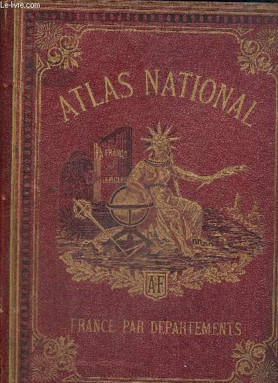
DE LA BRUGERE F.
Atlas National. 1ère livraison : Département de la Seine.
FAYARD & FILS. Non daté. In-Folio. Broché. Etat passable, 2ème plat abîmé, Dos satisfaisant, Intérieur acceptable. 4 pages. Quelques illustrations en noir et blanc, dans le texte. Déchirures sur le 2nd plat de couverture. Sans le plan.. . . . Classification Dewey : 912-Atlas, cartes et plans
Bookseller reference : RO80055204
|
|
|
DE LA MALENE PAULINE
ATLAS DE LA FRANCE ROMANE.
ZODIAQUE. 1995. In-4. Relié. Très bon état, Couv. convenable, Dos satisfaisant, Intérieur frais. 327 pages - jaquette en bon état - signet conservé - quelques photographies en couleurs hors texte - nombreux dessins en noir et blanc dans le texte - nombreuses cartes en couleurs hors texte - 2 photos disponibles.. Avec Jaquette. . . Classification Dewey : 912-Atlas, cartes et plans
Bookseller reference : R240083136
|
|
|
De Lange Nicholas
Atlas du monde juif.
Editions du Fanal. 1987. In-4. Relié. Bon état, Couv. convenable, Dos satisfaisant, Intérieur frais. 240 pages - jaquette en bon état - nombreuses photos et cartes en couleurs dans et hors texte.. Avec Jaquette. . . Classification Dewey : 912-Atlas, cartes et plans
Bookseller reference : R320144573

|
|
|
de la Brugère F., Trousset Jules
Atlas National contenant la Géographie physique, politique, historique, théorique, économique, militaire, agricole, industrielle et commerciale de la France et de ses colonies
Librairie historique et scientifique Arthême Fayard. 1877. In-4. Cartonnage d'éditeurs. Etat d'usage, Couv. légèrement passée, Dos satisfaisant, Quelques rousseurs. 500 pages. Texte sur trois colonnes. 115 cartes en couleurs hors texte. Gardes dominotées. Trois photos disponibles.. . . . Classification Dewey : 912-Atlas, cartes et plans
Bookseller reference : RO80250013
|
|
|
de la Brugère F.
Atlas universel contenant la géographie physique, politique, historique, économique, militaire, agricole, industrielle et commerciale des cinq parties du monde
Fayard Frères. Non daté. In-4. Relié demi-cuir. Etat d'usage, Coins frottés, Dos à nerfs, Papier jauni. 623 pages. Nombreuses illustrations monochromes dans le texte. Texte sur trois colonnes. Gardes marbrées. Ne contient pas de cartes. Trois photos disponibles.. . . . Classification Dewey : 912-Atlas, cartes et plans
Bookseller reference : RO80259392

|
|
|
de la Brugère F.
Atlas national contenant la géographie physique, politique, historique, économique, militaire, agricole, industrielle et commerciale de la France & des ses colonies
Fayard Frères. 1896. In-4. Relié demi-cuir. Etat d'usage, Coins frottés, Dos frotté, Papier jauni. 560 pages. Nombreuses illustrations monochromes dans le texte. Texte sur trois colonnes. 130 cartes en couleurs tirées à part, dont certaines dépliantes. Gardes marbrées. Titre et fleurons dorés au dos. Trois photos disponibles.. . . . Classification Dewey : 912-Atlas, cartes et plans
Bookseller reference : RO80259393

|
|
|
DE ROO PRISCILLA- LABORIE JEAN PAUL- COLLECTIF
Atlas de l'amenegement du territoire p
La documentation française / DATAR. 1988. In-4. Relié. Bon état, Couv. convenable, Dos satisfaisant, Intérieur frais. 367 pages illustrées de nombreuses cartes en couleur. . . . Classification Dewey : 912-Atlas, cartes et plans
Bookseller reference : RO20255595 ISBN : 2110020504

|
|
|
DE LANGE Nicholas
Atlas van de joodse wereld
Amsterdam, Elsevier 1986 240pp.rijkelijk geïll., gecart.band met stofwikkel, in-4, mooie staat
Bookseller reference : R43701
|
|
|
DE SAINT-SYLVESTRE H.
Atlas Zoologique à l'Usage de la Jeunesse.
Paris. Magnin et Fils. S.D. In-4. pleine toile rouge. Titre et ills. dorés. Composé de 24 planches en Chromo-Lithographie qui comprend 263 figs avec 44 p. de texte explicatif. BE.
Bookseller reference : 34643
|
|
|
DE LANGE Nicholas
Atlas du Monde Juif
Editions du Fanal 1987 240 pages in-4. 1987. Cartonné/Jaquette. 240 pages. Nombreuses illustrations en noir et en couleurs
Bookseller reference : 16964
|
|
|
De La Brugère F.
Carte de Paris Monumental : Un vrai guide du promeneur
Fayard Frères. 1896. In-Folio. En feuillets. Bon état, Livré sans Couverture, Dos satisfaisant, Intérieur frais. Une carte de Paris monumental sur double planche en couleurs. Dimensions de la planche : Environ 43 x 31 cm.. . . A l'italienne. Classification Dewey : 912-Atlas, cartes et plans
Bookseller reference : RO20228558

|
|
|
De La Brugère F.
Carte : Environs de Paris avec les nouveaux forts et le chemin de fer de grande ceinture
Fayard Frères. 1896. In-Folio. En feuillets. Etat d'usage, Livré sans Couverture, Dos satisfaisant, Intérieur frais. Une carte en couleurs des Environs de Paris avec les nouveaux forts et le chemin de fer de grande ceinture. Carte en couleurs sur double-planche. Déchirure au niveau de la pliure. Dimensions de la planche : Environ 46 x 31 cm. . . . Classification Dewey : 912-Atlas, cartes et plans
Bookseller reference : RO20228559

|
|
|
De La Brugère F.
Carte du département du Rhône
Fayard Frères. 1896. In-4. En feuillets. Bon état, Livré sans Couverture, Dos satisfaisant, Intérieur frais. Une carte en couleurs. Dimensions de la planche : Environ 23x 31 cm. Quelques pages de texte sur trois colonnes.. . . A l'italienne. Classification Dewey : 912-Atlas, cartes et plans
Bookseller reference : RO20228560

|
|
|
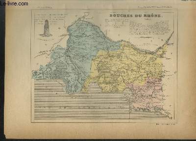
De La Brugère F.
Carte du département des Bouches du Rhône et Plan de Marseille
Fayard Frères. 1896. In-4. En feuillets. Bon état, Livré sans Couverture, Dos satisfaisant, Intérieur frais. Deux cartes en couleurs. Dimensions des planches : Envrion 23 x 31 cm. Quelques pages de texte sur trois colonnes.. . . A l'italienne. Classification Dewey : 912-Atlas, cartes et plans
Bookseller reference : RO20228565
|
|
|
De La Brugère F.
Carte de la Seine-Inférieure
Fayard Frères. 1896. In-4. En feuillets. Bon état, Livré sans Couverture, Dos satisfaisant, Intérieur frais. Une carte en couleurs. Dimensions de la planche : Envrion 23 x 31 cm. Quelques pages de texte sur trois colonnes.. . . A l'italienne. Classification Dewey : 912-Atlas, cartes et plans
Bookseller reference : RO20228566

|
|
|
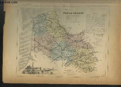
De La Brugère F.
Carte du département du Pas de Calais
Fayard Frères. 1896. In-Plano. En feuillets. Bon état, Livré sans Couverture, Dos satisfaisant, Intérieur frais. Une carte en couleurs. Dimensions de la planche : Envrion 23 x 31 cm. Quelques pages de texte sur trois colonnes.. . . A l'italienne. Classification Dewey : 912-Atlas, cartes et plans
Bookseller reference : RO20228568
|
|
|
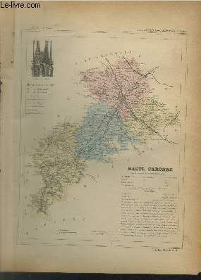
De La Brugère F.
Carte du département de la Haute Garonne et un plan de Toulouse
Fayard Frères. 1896. In-Plano. En feuillets. Bon état, Livré sans Couverture, Dos satisfaisant, Intérieur frais. Une carte en couleurs d'environ 23x31cm. Plan de Toulouse sur double-planche à l'italienne d'envrion 46 x 31 cm. Quelques pages de texte sur trois colonnes.. . . . Classification Dewey : 912-Atlas, cartes et plans
Bookseller reference : RO20228569
|
|
|
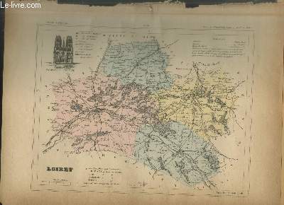
De La Brugère F.
Carte du département du Loiret
Fayard Frères. 1896. In-Plano. En feuillets. Bon état, Livré sans Couverture, Dos satisfaisant, Intérieur frais. Une carte en couleurs. Dimensions de la planche : Envrion 23 x 31 cm. Quelques pages de texte sur trois colonnes augmentées de quelques illustrations en noir et blanc.. . . A l'italienne. Classification Dewey : 912-Atlas, cartes et plans
Bookseller reference : RO20228570
|
|
|
De La Brugère F.
Carte du département de la Marne
Fayard Frères. 1896. In-4. En feuillets. Bon état, Livré sans Couverture, Dos satisfaisant, Intérieur frais. Une carte en couleurs. Dimensions de la planche : Envrion 23 x 31 cm. Quelques pages de texte sur trois colonnes augmentées de quelques illustrations en noir et blanc.. . . A l'italienne. Classification Dewey : 912-Atlas, cartes et plans
Bookseller reference : RO20228572

|
|
|
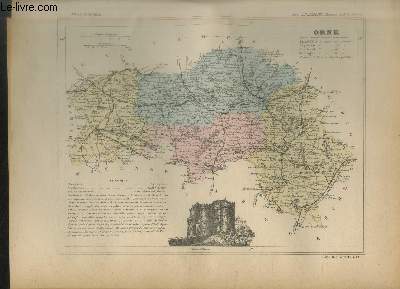
De La Brugère F.
Carte du département de l'Orne
Fayard Frères. 1896. In-Plano. En feuillets. Bon état, Livré sans Couverture, Dos satisfaisant, Intérieur frais. Une carte en couleurs. Dimensions de la planche : Envrion 23 x 31 cm. Quelques pages de texte sur trois colonnes augmentées de quelques illustrations en noir et blanc.. . . A l'italienne. Classification Dewey : 912-Atlas, cartes et plans
Bookseller reference : RO20228573
|
|
|
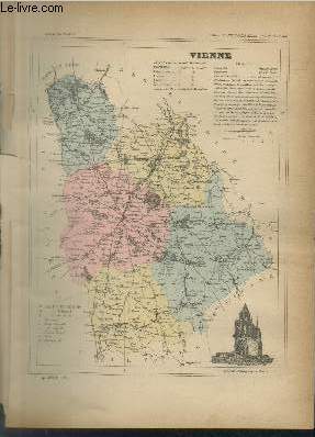
De La Brugère F.
Carte du département de la Vienne
Fayard Frères. 1896. In-4. En feuillets. Bon état, Livré sans Couverture, Dos satisfaisant, Intérieur frais. Une carte en couleurs. Dimensions de la planche : Envrion 23 x 31 cm. Quelques pages de texte sur trois colonnes augmentées de quelques illustrations en noir et blanc. Une petite déchirure en bordure.. . . . Classification Dewey : 912-Atlas, cartes et plans
Bookseller reference : RO20228574
|
|
|
De La Brugère F.
Carte du département de la Manche
Fayard Frères. 1896. In-4. En feuillets. Bon état, Livré sans Couverture, Dos satisfaisant, Intérieur frais. Une carte en couleurs. Dimensions de la planche : Envrion 23 x 31 cm. Quelques pages de texte sur trois colonnes augmentées de quelques illustrations en noir et blanc. Une déchirure en bordure.. . . . Classification Dewey : 912-Atlas, cartes et plans
Bookseller reference : RO20228575

|
|
 Receive by email
 Download as PDF document
 RSS feed


